


Winter Weather update Sunday 3pm.
Winter Weather update Sunday 3pm.


Joined:
X days ago
# Posts:
X,XXX
Contributor Points:
X


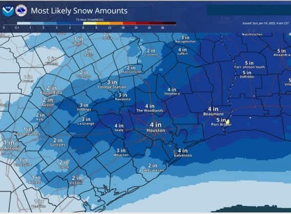
Winter Weather update Sunday 3pm. Damn. ❄️ 1-19-25 PM Potentially historic winter storm event for the area late Monday into Tuesday Heavy snow is becoming likely over much of the area. Travel WILL become impossible Tuesday into Wednesday. Motorists on area roadways may become stranded. Be in a safe location by 600pm Monday for the duration of this event. Trends today have indicated more snow and less sleet/freezing rain which has increased accumulation amounts over the area Widespread snow totals of 2-4 inches with isolated higher amounts in bands of up to 6+inches will be possible. Would not be surprised to see higher than 6 inch totals from Houston east along I-10 toward Lake Charles. Realistic worst case amounts (10%) chance of happening are in the 7-10 inch range over a large part of the area. I cannot stress enough that travel will become impossible with this type of snow in this area including all surface streets. Conditions will only slowly improve with very cold temperatures into Wednesday…better improvement should occur on Thursday. 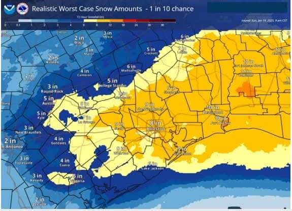


Discussion Summary:
"Severe Winter Storm Warning: Heavy Snow Expected Late Monday to Wednesday, Impassable Travel Conditions Likely"
"Severe Winter Storm Warning: Heavy Snow Expected Late Monday to Wednesday, Impassable Travel Conditions Likely"
Discussion Insights:
Ask a question about this discussion and an AI bot will try to give an answer.
Ask a question about this discussion and an AI bot will try to give an answer.
Replies:
Does anyone know if the area golf courses de-ice the fairways?
Winter Weather update Sunday 3pm. Damn. ❄️ 1-19-25 PM Potentially historic winter storm event for the area late Monday into Tuesday Heavy snow is becoming likely over much of the area. Travel WILL become impossible Tuesday into Wednesday. Motorists on area roadways may become stranded. Be in a safe location by 600pm Monday for the duration of this event. Trends today have indicated more snow and less sleet/freezing rain which has increased accumulation amounts over the area Widespread snow totals of 2-4 inches with isolated higher amounts in bands of up to 6+inches will be possible. Would not be surprised to see higher than 6 inch totals from Houston east along I-10 toward Lake Charles. Realistic worst case amounts (10%) chance of happening are in the 7-10 inch range over a large part of the area. I cannot stress enough that travel will become impossible with this type of snow in this area including all surface streets. Conditions will only slowly improve with very cold temperatures into Wednesday…better improvement should occur on Thursday.
StormChaser : What time tomorrow is it expected to sleet? People driving home at five ok?

|
Winter Storm Warnings are now posted for Monday night and Tuesday as model trends today continue to support a bonafide snowstorm in the Houston area. Matt explains what's new, the risks to the snow forecast, where this may end up historically, and whether we could experience BLIZZARD conditions in Galveston. Read up here: spacecityweather.com /a-winter-storm-warn ing-is-now-in-effect -for-the-entire
 StormChaser :
 Now the storm begins Monday at midnight; it is getting progressively later. Was 2pm, then yesterday, they said 6pm, now the mayor is quoting radar that says it will come in about midnight. But Wed-Fri are freezes at night, warm ups in the day, so it will be an interesting week. Stay warm and safe!
|
|
StormChaser : What time tomorrow is it expected to sleet? People driving home at five ok?
HappyDay2016 : After 6pm « Back to Chat
Views: 938
# Replies: 14