


This week's stormy forecast
This week's stormy forecast


Joined:
X days ago
# Posts:
X,XXX
Contributor Points:
X


This week's stormy forecast ❇️ Another round of stormy weather starts tomorrow morning (Tuesday) through late Wednesday morning.
❇️ We could see a few typical May sea breeze thunderstorms pop up later this afternoon but those are forecasted to stay west of us. Still, the chance is there area wide today.
❇️ Showers (mostly just rain) is possible this evening & thru the overnight hours.
❇️ Tomorrow (Tuesday), I expect a flood watch to be issued for much of our area as well as a severe thunderstorm and/or tornado watch. 🌪⚡️ 🚨 Late tomorrow morning - Wednesday, the potential is there for all forms of severe weather, including: 💧 Flooding,
🧊 Hail
🌬 Damaging winds
⚡️Frequent lightning & thunder
🌪 and even tornadoes. From Space City Weather: After a gorgeous weekend, storms return to the forecast for Houston. Eric Berger · Monday, May 5, 2025 7:31 AM In brief: *Monday will be calm but you should anticipate the potential for showers, thunderstorms, and heavy rainfall on Tuesday and Wednesday.
*We don't have high confidence in the timing yet, but with the current atmosphere in place, we can be pretty confident in disruptions.
*We have issued a Stage 1 flood alert in place through Wednesday. Things calm down after that. MONDAY: *Humidity is already on the rise this morning, and we'll see southeasterly winds gusting up to 25 mph that will set the stage for more moisture in the air.
*We'll start out with partly sunny skies this morning, but by some point this afternoon, we should see mostly cloudy skies.
*High temperatures will reach the vicinity of 80 degrees.
*By this afternoon and evening, we will see some scattered showers, mainly located to the west of Interstate 45.
*A chance of light rain will spread into the entire region during the overnight hours as lows fall to around 70 degrees. 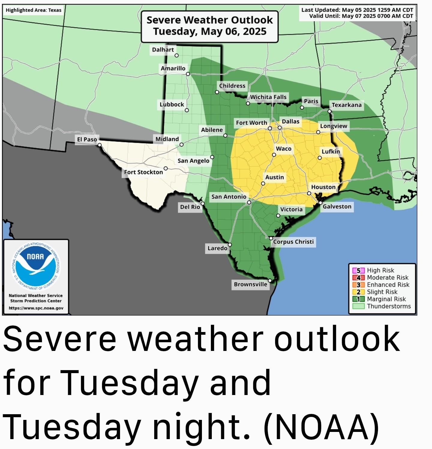 TUESDAY AND WEDNESDAY: *The moisture that moved inland on Monday was a "warm" front, and it will set the stage for the possibility of heavy rainfall and storms on Tuesday and Wednesday in the Houston metro area.
*Our various high resolution models still have some discrepancies, but right now I would predict that the greatest potential for inclement weather will occur from late Tuesday morning through Wednesday morning across the region. 🚨 There will be the usual threats: ➡️ Damaging winds, hail, and possibly a tornado or 2. ➡️ We are also concerned about the potential for heavy rainfall. *Most areas are likely to pick up 1 to 3 inches of rain through Wednesday but we could see some higher bullseyes of 5+ inches or more.
*For this reason we are going to institute a Stage 1 flood alert from Tuesday at noon through Wednesday.
*In terms of temperatures, Houston should reach the lower 80s on both days with plenty of humidity. We'll have more on this later today and plenty of coverage the rest of the week. (I'll post that update when they do) 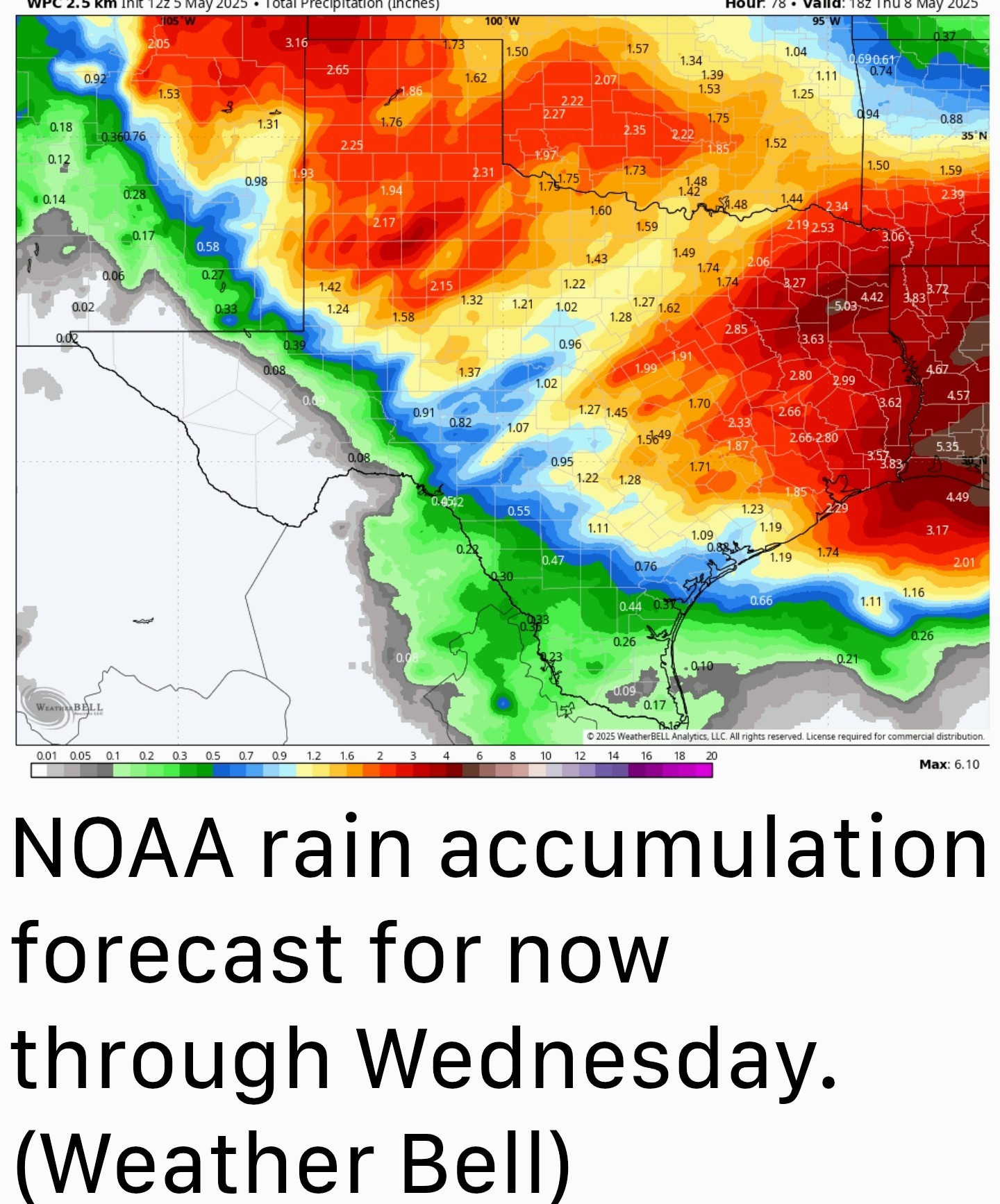 THURSDAY: *Rain chances should diminish by Thursday, but will perhaps not go away entirely until the afternoon.
*Expect partly sunny skies and high temperatures in the low to mid 80s.
*Lows on Thursday night should drop into the upper 60s. FRIDAY, SATURDAY AND SUNDAY: *As a weak front drifts into the area, we should see another nice weekend.
*I don't know if we're going to run it back, and have things as nice as we just experienced, but as of now I anticipate mostly sunny skies with highs in the low 80s, overnight lows in the 60s, and modestly drier air.
*So if it's not cool as this past weekend, it will hopefully at least be somewhat pleasant.


❇️ We could see a few typical May sea breeze thunderstorms pop up later this afternoon but those are forecasted to stay west of us. Still, the chance is there area wide today.
❇️ Showers (mostly just rain) is possible this evening & thru the overnight hours.
❇️ Tomorrow (Tuesday), I expect a flood watch to be issued for much of our area as well as a severe thunderstorm and/or tornado watch. 🌪⚡️
🧊 Hail
🌬 Damaging winds
⚡️Frequent lightning & thunder
🌪 and even tornadoes.
******************
*We don't have high confidence in the timing yet, but with the current atmosphere in place, we can be pretty confident in disruptions.
*We have issued a Stage 1 flood alert in place through Wednesday.
*We'll start out with partly sunny skies this morning, but by some point this afternoon, we should see mostly cloudy skies.
*High temperatures will reach the vicinity of 80 degrees.
*By this afternoon and evening, we will see some scattered showers, mainly located to the west of Interstate 45.
*A chance of light rain will spread into the entire region during the overnight hours as lows fall to around 70 degrees.
*Our various high resolution models still have some discrepancies, but right now I would predict that the greatest potential for inclement weather will occur from late Tuesday morning through Wednesday morning across the region.
*For this reason we are going to institute a Stage 1 flood alert from Tuesday at noon through Wednesday.
*In terms of temperatures, Houston should reach the lower 80s on both days with plenty of humidity.
*Expect partly sunny skies and high temperatures in the low to mid 80s.
*Lows on Thursday night should drop into the upper 60s.
*I don't know if we're going to run it back, and have things as nice as we just experienced, but as of now I anticipate mostly sunny skies with highs in the low 80s, overnight lows in the 60s, and modestly drier air.
*So if it's not cool as this past weekend, it will hopefully at least be somewhat pleasant.
Replies:

|
StormChaser : Thanks for the forecast. I wish we could just get rain without the threat of tornadoes, hail and high winds.
|
|
I should have taken pics on Friday. The clouds were rotating in Atascocita. It was creepy!
SummerSneeze : Also it was really dark here at 2. Looked like about 9 outside.
|
|
peppermintstick : It really did look like night time. I got the Midwest tornado tingles lol.
SummerSneeze : I was picking up my kiddo from KPark and it looked like 9pm outside, not 3pm! Sheets of rain were being blown across the road at least 40mph.
|
|
1:30pm update Looking at models for this afternoon, the HRRR (High Resolution Rapid Refresh model) shows storms firing up here in Houston after 4pm. This particular model absolutely nailed the timing of last week's storms - down to the hour - so I'm curious to see if that will repeat with this week's system. The link below is to that HRRR Model. weather.us/model-cha rts/rapid-us/texas/r adar-reflectivity/20 250505-1800z.ht If you click on the black arrow (seen in the pic below), it will show the radar forecast hour by hour, based on current conditions. 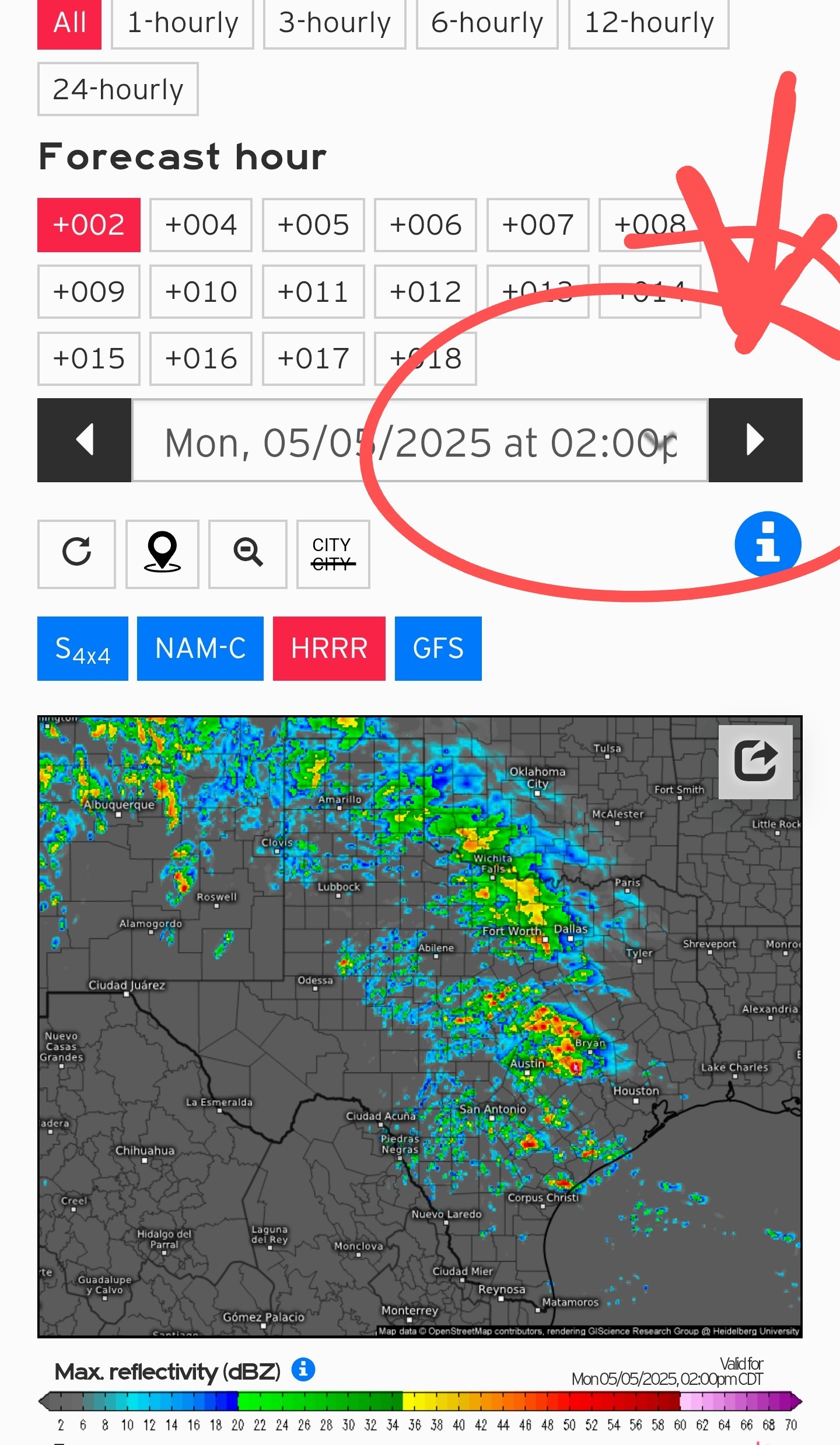 Here is a screenshot of what 5pm could look like here in Htown.
 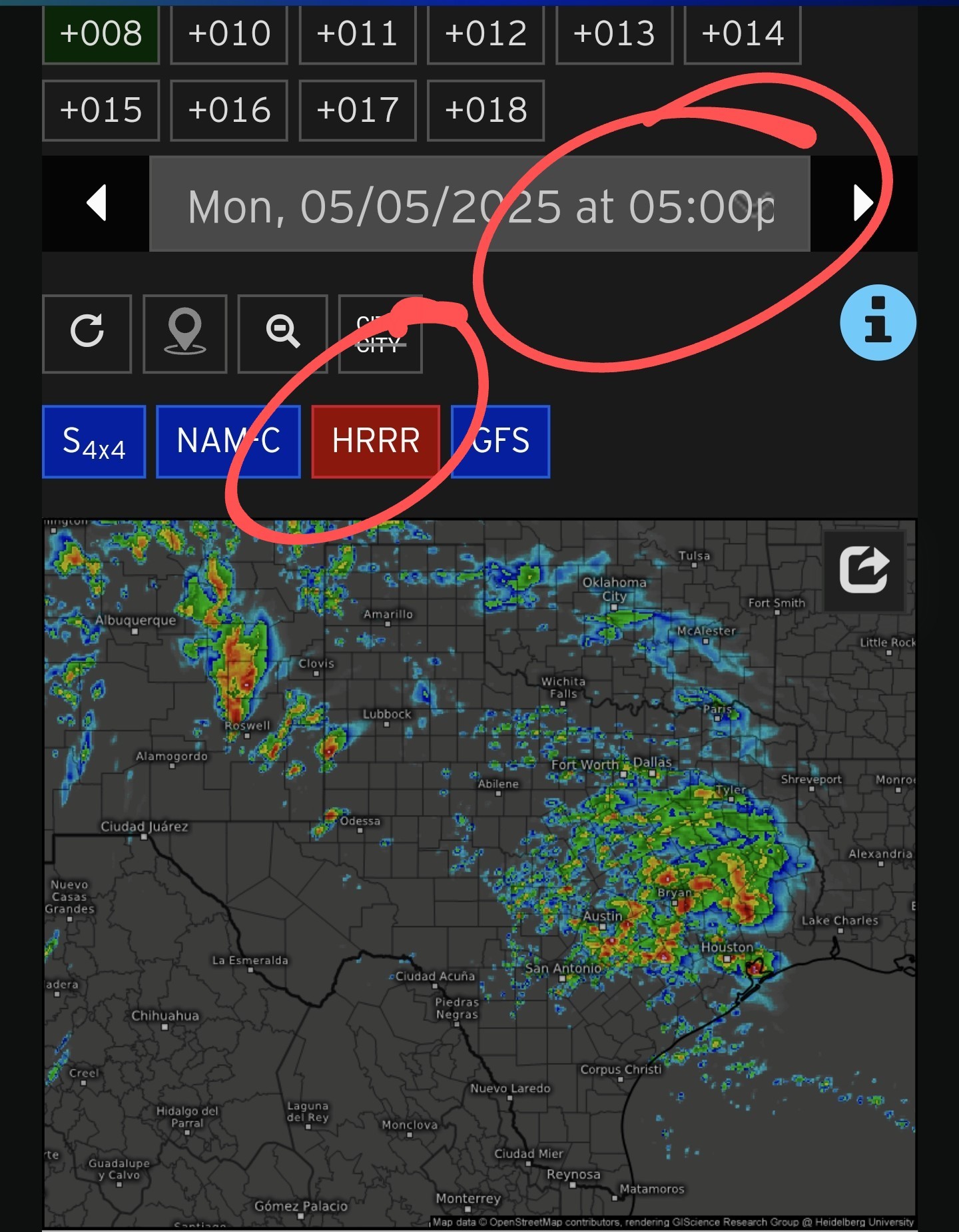 We'll see if this pans out but I wanted to give y'all the heads up. This model has consistently been one of the best but I'll update if needed. 👍 *Here is the current radar a 1:30pm and showers & storms have formed off to our west, as expected.
*As of this AM, they were forecasted to stay to our west until much later this evening, but it looks like they might push into Harris county by rush hour or so. Again, we'll see. I'll update y'all a bit later. ⚡️ 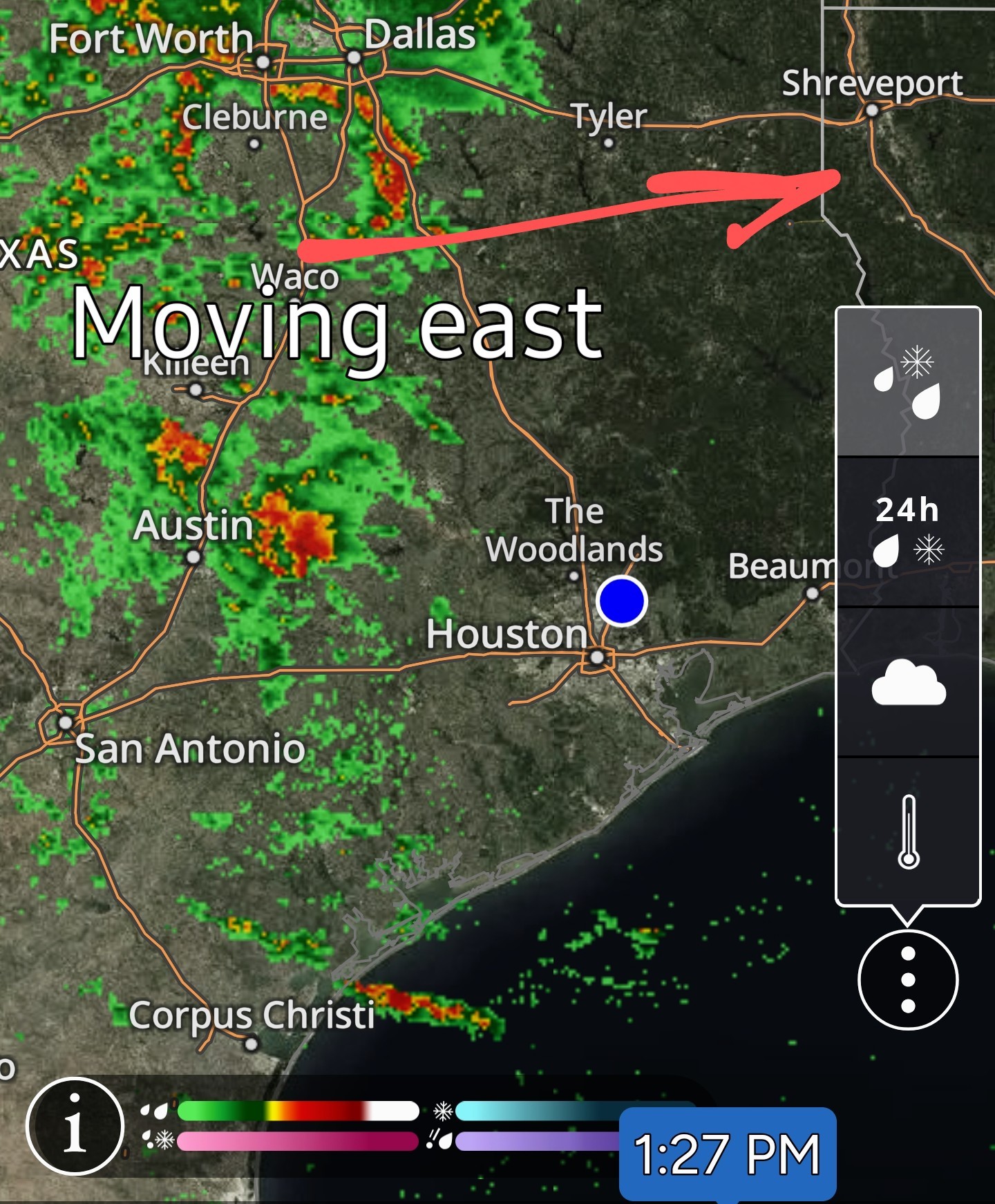
*As of this AM, they were forecasted to stay to our west until much later this evening, but it looks like they might push into Harris county by rush hour or so.
|
|
And it looks like the HRRR was right! Severe Thunderstorm watch until 8pm for Harris county. www.kingwood.com/mes sage_board/view_mess age.php?parent_messa ge_id=5586800&l
« Back to Chat
Views: 1,005
# Replies: 10