


This week's forecast
This week's forecast


Joined:
X days ago
# Posts:
X,XXX
Contributor Points:
X


This week's forecast This week's forecast From Space City Weather: In brief: *In today's post we look at windy conditions over night, in which large chunks of the region saw gusts of 45 to 55 mph.
*This wind is leading to very chilly conditions this morning, and we'll only warm up a little bit today.
*Temperatures tonight will get into the 30s for much of the area, but should remain above freezing. MONDAY - *Although cold temperatures trailed the wind, much colder air did begin to make serious progress into the region after midnight.
*Air temperatures this morning range from the low 40s north of Houston to upper 40s in the city, with slightly warmer conditions near the coast.
*When you tack winds on, temperatures feel like they're in the 30s across the area, so very chilly out there.
*Highs won't climb much today despite the sunny skies.
*Most of us won't get higher than the mid-50s this afternoon.
*So far the winds have had a negligible impact on power outages. Houston rodeo weather - *Although winds will fall off this afternoon and early evening, they're not going away.
*We should still see some gusts in the 20 to 25 mph range before tonight's show.
*Air temperatures before the show will be about 50 degrees, falling to the upper 40s afterward.
*So with the wind chill it will be quite brisk outside.
*Winds should finally die off by or before midnight tonight.
*Lows in Houston will bottom out at about 40 degrees in the urban core of Houston, with much of the outlying area falling into the mid- to upper-30s tonight. 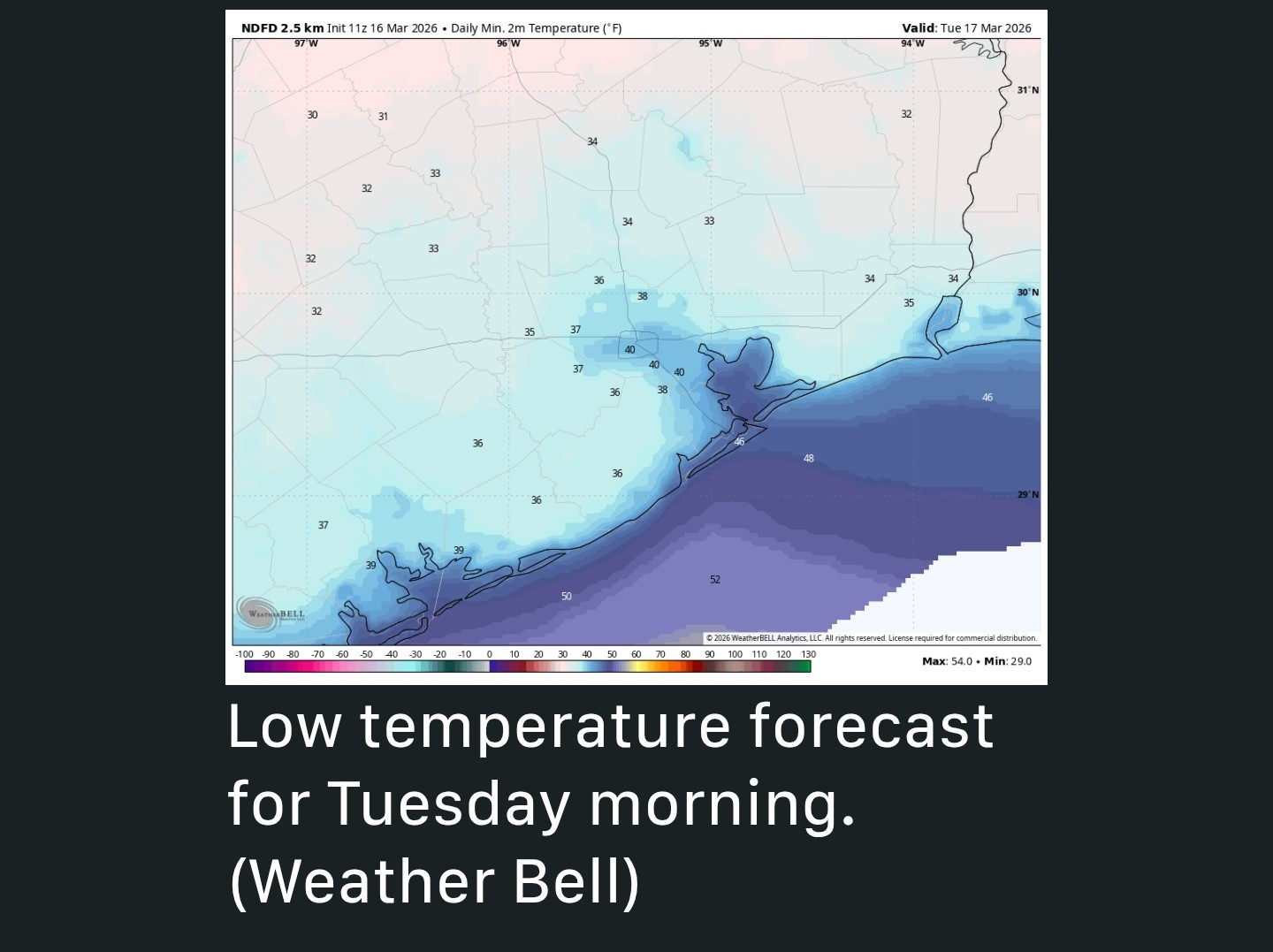 TUESDAY - *This will be a sunny day with high temperatures in the low 60s.
*I feel pretty confident in saying this is likely to be Houston's coldest daytime temperature until at least October, or possibly even November.
*Monday and Tuesday are probably our last "winter-like" days in Houston until next winter.
*Winds will be almost entirely gone, but importantly they will subtly shift from the northeast to southeast, which will eventually bring us much warmer weather.
*Lows on Tuesday night should fall into the upper 40s in Houston. WEDNESDAY, THURSDAY, and FRIDAY - *Sunshine will prevail for the rest of the week as we see a warming trend from highs in the mid-70s on Wednesday to the mid-80s on Friday.
*Overnight lows will be in the 50s and 60s.
*Humidity comes back but it should not be oppressive. SATURDAY and SUNDAY - *The weekend looks sunny and hot, with highs in the mid to upper 80s.
*Some inland locations might even flirt with 90 degrees-quite the turnaround from this morning.
*Rain chances are nil. NEXT WEEK - *The first half of next week should see continued, rather hot weather for March.
*The pattern may change by the middle of next week (or not!) with an increase in rain chances and possibly a front.
*Although I must say this is far enough into the future that my overall confidence is rather low.
*By then we'll definitely be back in the "We could sure use some rain" camp. ........ WINDY CONDITIONS - *In the wake of Sunday evening's cold front a river of winds in the atmosphere has, essentially, dipped down to ground level. 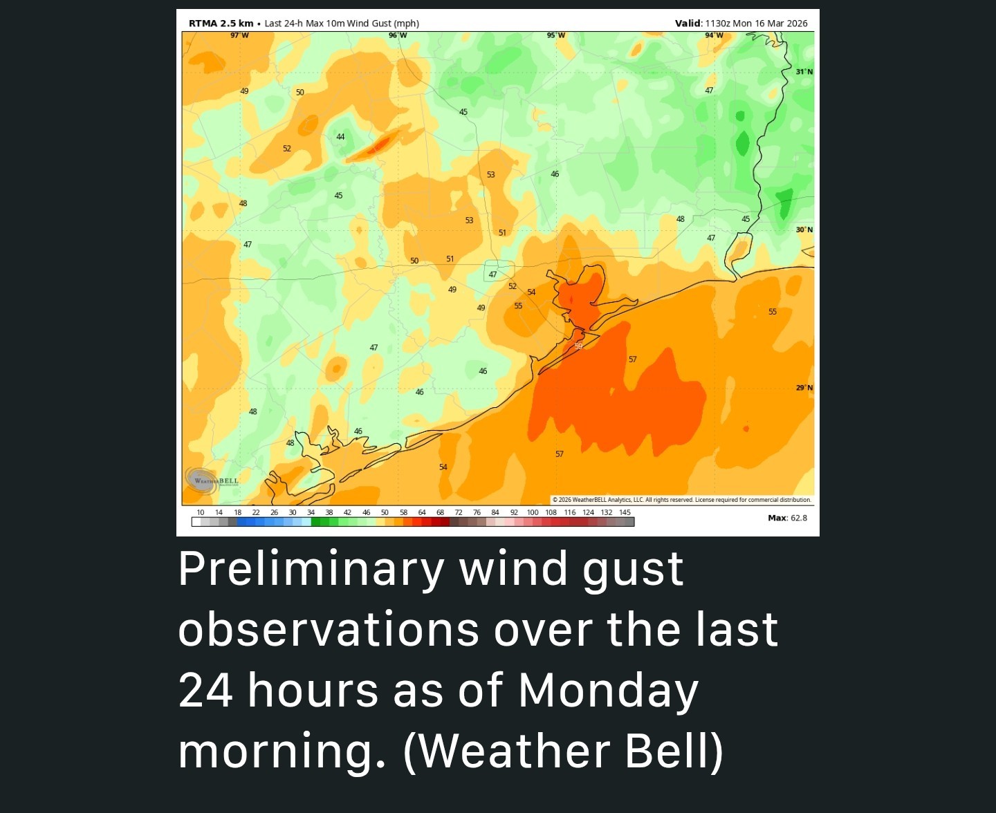 *This has brought very windy conditions across the region overnight.
*Much of the area has experienced gusts of 45 to 55 mph, with even higher ones along the coast.
*At 3:52 am this morning, for example, Galveston recorded sustained winds of 43 mph, and a gust of 58 mph; Those are tropical-storm force winds.
*Winds will die down slightly over the next few hours.
*We will continue to see a very blustery day, with gusts of 30 to 35 mph possible until later this afternoon when things finally settle down for awhile.


CatalinaKitKat, cbear and malpalface reacted *This wind is leading to very chilly conditions this morning, and we'll only warm up a little bit today.
*Temperatures tonight will get into the 30s for much of the area, but should remain above freezing.
*Air temperatures this morning range from the low 40s north of Houston to upper 40s in the city, with slightly warmer conditions near the coast.
*When you tack winds on, temperatures feel like they're in the 30s across the area, so very chilly out there.
*Highs won't climb much today despite the sunny skies.
*Most of us won't get higher than the mid-50s this afternoon.
*So far the winds have had a negligible impact on power outages.
*We should still see some gusts in the 20 to 25 mph range before tonight's show.
*Air temperatures before the show will be about 50 degrees, falling to the upper 40s afterward.
*So with the wind chill it will be quite brisk outside.
*Winds should finally die off by or before midnight tonight.
*Lows in Houston will bottom out at about 40 degrees in the urban core of Houston, with much of the outlying area falling into the mid- to upper-30s tonight.
*I feel pretty confident in saying this is likely to be Houston's coldest daytime temperature until at least October, or possibly even November.
*Monday and Tuesday are probably our last "winter-like" days in Houston until next winter.
*Winds will be almost entirely gone, but importantly they will subtly shift from the northeast to southeast, which will eventually bring us much warmer weather.
*Lows on Tuesday night should fall into the upper 40s in Houston.
*Overnight lows will be in the 50s and 60s.
*Humidity comes back but it should not be oppressive.
*Some inland locations might even flirt with 90 degrees-quite the turnaround from this morning.
*Rain chances are nil.
*The pattern may change by the middle of next week (or not!) with an increase in rain chances and possibly a front.
*Although I must say this is far enough into the future that my overall confidence is rather low.
*By then we'll definitely be back in the "We could sure use some rain" camp.
*Much of the area has experienced gusts of 45 to 55 mph, with even higher ones along the coast.
*At 3:52 am this morning, for example, Galveston recorded sustained winds of 43 mph, and a gust of 58 mph; Those are tropical-storm force winds.
*Winds will die down slightly over the next few hours.
*We will continue to see a very blustery day, with gusts of 30 to 35 mph possible until later this afternoon when things finally settle down for awhile.
Replies:
StormChaser : I'm pretty confident that we won't see these temps till December so I'm going to keep windows open and bask in the crisp coldness.

|

This week's forecast This week's forecast From Space City Weather: In brief: *In today's post we look at windy conditions over night, in which large chunks of the region saw gusts of 45 to 55 mph. *This wind is leading to very chilly conditions this morning, and we'll only warm up a little bit today. *Temperatures tonight will get into the 30s for much of the area, but should remain above freezing. MONDAY - *Although cold temperatures trailed the wind, much colder air did begin to make serious progress into the region after midnight. *Air temperatures this morning range from the low 40s north of Houston to upper 40s in the city, with slightly warmer conditions near the coast. *When you tack winds on, temperatures feel like they're in the 30s across the area, so very chilly out there. *Highs won't climb much today despite the sunny skies. *Most of us won't get higher than the mid-50s this afternoon. *So far the winds have had a negligible impact on power outages. Houston rodeo weather - *Although winds will fall off this afternoon and early evening, they're not going away. *We should still see some gusts in the 20 to 25 mph range before tonight's show. *Air temperatures before the show will be about 50 degrees, falling to the upper 40s afterward. *So with the wind chill it will be quite brisk outside. *Winds should finally die off by or before midnight tonight. *Lows in Houston will bottom out at about 40 degrees in the urban core of Houston, with much of the outlying area falling into the mid- to upper-30s tonight. TUESDAY - *This will be a sunny day with high temperatures in the low 60s. *I feel pretty confident in saying this is likely to be Houston's coldest daytime temperature until at least October, or possibly even November. *Monday and Tuesday are probably our last "winter-like" days in Houston until next winter. *Winds will be almost entirely gone, but importantly they will subtly shift from the northeast to southeast, which will eventually bring us much warmer weather. *Lows on Tuesday night should fall into the upper 40s in Houston. WEDNESDAY, THURSDAY, and FRIDAY - *Sunshine will prevail for the rest of the week as we see a warming trend from highs in the mid-70s on Wednesday to the mid-80s on Friday. *Overnight lows will be in the 50s and 60s. *Humidity comes back but it should not be oppressive. SATURDAY and SUNDAY - *The weekend looks sunny and hot, with highs in the mid to upper 80s. *Some inland locations might even flirt with 90 degrees-quite the turnaround from this morning. *Rain chances are nil. NEXT WEEK - *The first half of next week should see continued, rather hot weather for March. *The pattern may change by the middle of next week (or not!) with an increase in rain chances and possibly a front. *Although I must say this is far enough into the future that my overall confidence is rather low. *By then we'll definitely be back in the "We could sure use some rain" camp. ........ WINDY CONDITIONS - *In the wake of Sunday evening's cold front a river of winds in the atmosphere has, essentially, dipped down to ground level. *This has brought very windy conditions across the region overnight. *Much of the area has experienced gusts of 45 to 55 mph, with even higher ones along the coast. *At 3:52 am this morning, for example, Galveston recorded sustained winds of 43 mph, and a gust of 58 mph; Those are tropical-storm force winds. *Winds will die down slightly over the next few hours. *We will continue to see a very blustery day, with gusts of 30 to 35 mph possible until later this afternoon when things finally settle down for awhile.
StormChaser : Orangeapple : All the wind and just in the air. I was disappointed that we didn't get any rain. I put weed N feed down on Saturday thinking it would rain last night. Looks like I am going to run the sprinkler today.
Winter and summer, all in one week, in the spring.
Gotta love the Houston area
malpalface and GiggleMugs reacted Gotta love the Houston area
« Back to Chat
Views: 195
# Replies: 4