


This week's forecast
This week's forecast


Joined:
X days ago
# Posts:
X,XXX
Contributor Points:
X


This week's forecast *Much needed rain chances are back in the forecast.
*We'll have daily chances of 20-30% after today.
*Those percentages drastically increase this weekend.
*Temps will remain unseasonably warm until the middle of next week. Also, time change is next Sunday! 🌞 .......... From Space City Weather: Saddle up Houston as we ride into a warm week with a good soaking at the end Eric Berger · Monday, March 2, 2026 6:57 AM In brief: *In today's post we discuss our unseasonably warm weather this week, which will persist into the weekend.
*The big thing we're watching for is rain chances this weekend, which will be pretty high, although exact accumulations are impossible to forecast right now. MONDAY - *Conditions are fairly warm for early March out there with temperatures in the low to mid 60s this morning.
*We are going to see warm-ish weather all week as a southerly flow dominates our weather.
*High temperatures today will reach the lower 80s with mostly sunny skies and modest winds from the southeast. RODEO DAY 1 FORECAST MONDAY NIGHT - If you're headed out to the Houston Livestock Show and Rodeo this evening we really have no weather concerns for you. *Expect partly sunny skies before sunset with mild temps in the mid 70s before the show.
*Winds will be from the south at 10 to 15 mph.
*Afterward there will be increasing clouds with temperatures in the upper 60s.
*Overnight lows will not drop much further, only reaching the mid-60s for most of the region. TUESDAY, WEDNESDAY, THURSDAY, and FRIDAY - Our forecast won't change much this week. *A front will approach the area, but should stall out before moving into the Houston region.
*As a result each of these days should see high temperatures in the low to mid 80s, with somewhat humid air.
*Overnight lows will fall only into the upper 60s.
*As a persistent southerly flow remains in place we can expect skies to be cloudy most of the time and our nights to be warm.
*Daily rain chances will, overall, be on the order of 20 to 30 percent.
*Areas well to the northwest of Houston, such as College Station, have a better chance of seeing rain this week.
*Anyway, this will be our warmest and muggiest week of the year so far. SATURDAY, SUNDAY, and MONDAY - *The weekend looks rainy for much of the state of Texas as a series of disturbances push through.
*We still don't have high confidence in rain accumulations for the Houston area, but there is the potential for 1 to 3 inches from Saturday through Monday, with higher isolated amounts.
*Rain totals area likely to be even greater for central and northern Texas, where locations could see 3 to 5 inches, and there is the potential for some flooding. (Matt will have more on the broader Texas implications on The Eyewall later this morning).
*For Houston, I don't expect wall to wall rain, but rather we should see cloudy skies this weekend with muggy temperatures and on-and-off showers.
*If you have outdoor plans we'll be able to better refine the forecast the closer we get. 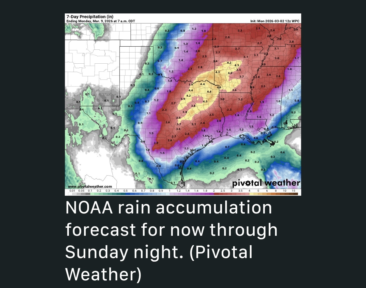 LATER NEXT WEEK - *After unseasonably warm weather for the next week or so, by Tuesday or Wednesday of next week a cold front should push into the area.
*It's a long ways off, but this should bring cooler nights back into Houston, with lows in the vicinity of 50 degrees or so.
*As always, at 10 days out, the details are pretty fuzzy.


peppermintstick, golfshot and CatalinaKitKat + 3 more reacted *We'll have daily chances of 20-30% after today.
*Those percentages drastically increase this weekend.
*Temps will remain unseasonably warm until the middle of next week.
*The big thing we're watching for is rain chances this weekend, which will be pretty high, although exact accumulations are impossible to forecast right now.
*We are going to see warm-ish weather all week as a southerly flow dominates our weather.
*High temperatures today will reach the lower 80s with mostly sunny skies and modest winds from the southeast.
*Winds will be from the south at 10 to 15 mph.
*Afterward there will be increasing clouds with temperatures in the upper 60s.
*Overnight lows will not drop much further, only reaching the mid-60s for most of the region.
*As a result each of these days should see high temperatures in the low to mid 80s, with somewhat humid air.
*Overnight lows will fall only into the upper 60s.
*As a persistent southerly flow remains in place we can expect skies to be cloudy most of the time and our nights to be warm.
*Daily rain chances will, overall, be on the order of 20 to 30 percent.
*Areas well to the northwest of Houston, such as College Station, have a better chance of seeing rain this week.
*Anyway, this will be our warmest and muggiest week of the year so far.
*We still don't have high confidence in rain accumulations for the Houston area, but there is the potential for 1 to 3 inches from Saturday through Monday, with higher isolated amounts.
*Rain totals area likely to be even greater for central and northern Texas, where locations could see 3 to 5 inches, and there is the potential for some flooding. (Matt will have more on the broader Texas implications on The Eyewall later this morning).
*For Houston, I don't expect wall to wall rain, but rather we should see cloudy skies this weekend with muggy temperatures and on-and-off showers.
*If you have outdoor plans we'll be able to better refine the forecast the closer we get.
*It's a long ways off, but this should bring cooler nights back into Houston, with lows in the vicinity of 50 degrees or so.
*As always, at 10 days out, the details are pretty fuzzy.
Replies:

|


This week's forecast *Much needed rain chances are back in the forecast. *We'll have daily chances of 20-30% after today. *Those percentages drastically increase this weekend. *Temps will remain unseasonably warm until the middle of next week. Also, time change is next Sunday! 🌞 .......... From Space City Weather: Saddle up Houston as we ride into a warm week with a good soaking at the end Eric Berger · Monday, March 2, 2026 6:57 AM In brief: *In today's post we discuss our unseasonably warm weather this week, which will persist into the weekend. *The big thing we're watching for is rain chances this weekend, which will be pretty high, although exact accumulations are impossible to forecast right now. MONDAY - *Conditions are fairly warm for early March out there with temperatures in the low to mid 60s this morning. *We are going to see warm-ish weather all week as a southerly flow dominates our weather. *High temperatures today will reach the lower 80s with mostly sunny skies and modest winds from the southeast. RODEO DAY 1 FORECAST MONDAY NIGHT - If you're headed out to the Houston Livestock Show and Rodeo this evening we really have no weather concerns for you. *Expect partly sunny skies before sunset with mild temps in the mid 70s before the show. *Winds will be from the south at 10 to 15 mph. *Afterward there will be increasing clouds with temperatures in the upper 60s. *Overnight lows will not drop much further, only reaching the mid-60s for most of the region. TUESDAY, WEDNESDAY, THURSDAY, and FRIDAY - Our forecast won't change much this week. *A front will approach the area, but should stall out before moving into the Houston region. *As a result each of these days should see high temperatures in the low to mid 80s, with somewhat humid air. *Overnight lows will fall only into the upper 60s. *As a persistent southerly flow remains in place we can expect skies to be cloudy most of the time and our nights to be warm. *Daily rain chances will, overall, be on the order of 20 to 30 percent. *Areas well to the northwest of Houston, such as College Station, have a better chance of seeing rain this week. *Anyway, this will be our warmest and muggiest week of the year so far. SATURDAY, SUNDAY, and MONDAY - *The weekend looks rainy for much of the state of Texas as a series of disturbances push through. *We still don't have high confidence in rain accumulations for the Houston area, but there is the potential for 1 to 3 inches from Saturday through Monday, with higher isolated amounts. *Rain totals area likely to be even greater for central and northern Texas, where locations could see 3 to 5 inches, and there is the potential for some flooding. (Matt will have more on the broader Texas implications on The Eyewall later this morning). *For Houston, I don't expect wall to wall rain, but rather we should see cloudy skies this weekend with muggy temperatures and on-and-off showers. *If you have outdoor plans we'll be able to better refine the forecast the closer we get. LATER NEXT WEEK - *After unseasonably warm weather for the next week or so, by Tuesday or Wednesday of next week a cold front should push into the area. *It's a long ways off, but this should bring cooler nights back into Houston, with lows in the vicinity of 50 degrees or so. *As always, at 10 days out, the details are pretty fuzzy.
StormChaser : Rain IS so desperately needed. I don't care if it is on the weekend. My birthday is Sunday along with the time change which seems early this year.
|
|
This week's forecast *Much needed rain chances are back in the forecast. *We'll have daily chances of 20-30% after today. *Those percentages drastically increase this weekend. *Temps will remain unseasonably warm until the middle of next week. Also, time change is next Sunday! 🌞 .......... From Space City Weather: Saddle up Houston as we ride into a warm week with a good soaking at the end Eric Berger · Monday, March 2, 2026 6:57 AM In brief: *In today's post we discuss our unseasonably warm weather this week, which will persist into the weekend. *The big thing we're watching for is rain chances this weekend, which will be pretty high, although exact accumulations are impossible to forecast right now. MONDAY - *Conditions are fairly warm for early March out there with temperatures in the low to mid 60s this morning. *We are going to see warm-ish weather all week as a southerly flow dominates our weather. *High temperatures today will reach the lower 80s with mostly sunny skies and modest winds from the southeast. RODEO DAY 1 FORECAST MONDAY NIGHT - If you're headed out to the Houston Livestock Show and Rodeo this evening we really have no weather concerns for you. *Expect partly sunny skies before sunset with mild temps in the mid 70s before the show. *Winds will be from the south at 10 to 15 mph. *Afterward there will be increasing clouds with temperatures in the upper 60s. *Overnight lows will not drop much further, only reaching the mid-60s for most of the region. TUESDAY, WEDNESDAY, THURSDAY, and FRIDAY - Our forecast won't change much this week. *A front will approach the area, but should stall out before moving into the Houston region. *As a result each of these days should see high temperatures in the low to mid 80s, with somewhat humid air. *Overnight lows will fall only into the upper 60s. *As a persistent southerly flow remains in place we can expect skies to be cloudy most of the time and our nights to be warm. *Daily rain chances will, overall, be on the order of 20 to 30 percent. *Areas well to the northwest of Houston, such as College Station, have a better chance of seeing rain this week. *Anyway, this will be our warmest and muggiest week of the year so far. SATURDAY, SUNDAY, and MONDAY - *The weekend looks rainy for much of the state of Texas as a series of disturbances push through. *We still don't have high confidence in rain accumulations for the Houston area, but there is the potential for 1 to 3 inches from Saturday through Monday, with higher isolated amounts. *Rain totals area likely to be even greater for central and northern Texas, where locations could see 3 to 5 inches, and there is the potential for some flooding. (Matt will have more on the broader Texas implications on The Eyewall later this morning). *For Houston, I don't expect wall to wall rain, but rather we should see cloudy skies this weekend with muggy temperatures and on-and-off showers. *If you have outdoor plans we'll be able to better refine the forecast the closer we get. LATER NEXT WEEK - *After unseasonably warm weather for the next week or so, by Tuesday or Wednesday of next week a cold front should push into the area. *It's a long ways off, but this should bring cooler nights back into Houston, with lows in the vicinity of 50 degrees or so. *As always, at 10 days out, the details are pretty fuzzy.
StormChaser : Let it rain! All the little critters, birds, plants and trees need a drink! « Back to Chat
Views: 241
# Replies: 2