


This week's forecast
This week's forecast


Joined:
X days ago
# Posts:
X,XXX
Contributor Points:
X


This week's forecast TODAY through FRIDAY:
🎅 Highs near 80 & lows in the mid 60s
🎅 Partly to mostly sunny each day with humid & muggy conditions.
🎅 Dense fog likely each AM. THE WEEKEND:
🎄 Light showers possible before a front arrives late Sunday. NEXT WEEK:
📆 Temps get back to normal with lows in the 40s & highs in the 60s. NEW YEARS:
🥂 A warming trend is likely for NYE but it's still too soon to know the exact details. ........................ From Space City Weather: It's beginning to feel NOT 🚫 like Christmas, everywhere you go....  In brief: 🎄 In this morning's post, we provide an update on our toasty weather for this week.
🎄 If the unseasonable heat has you hot and bothered, we now have a pretty firm expiration date for our warm conditions. Unseasonable seasons greetings 🔥🔥🔥 🎄 Well, here we are, a mere three days before Christmas Day. And instead of "ho, ho, ho" any visiting Santa Clauses are more likely to say, "hot, hot, hot!" (And who could blame them?)
🎄 High temperatures this week will likely reach 80 degrees every day through Saturday, or get very close to it, with nights in the mid-60s.
🎄 In terms of what is normal for this time of year, we are generally running about 15 degrees above where the December mercury usually resides.
🎄 As we have been saying for awhile now, a potent high pressure system has set up over the central United States; nearly the entire Lower 48 is going to see abnormally high temperatures during Christmas week. 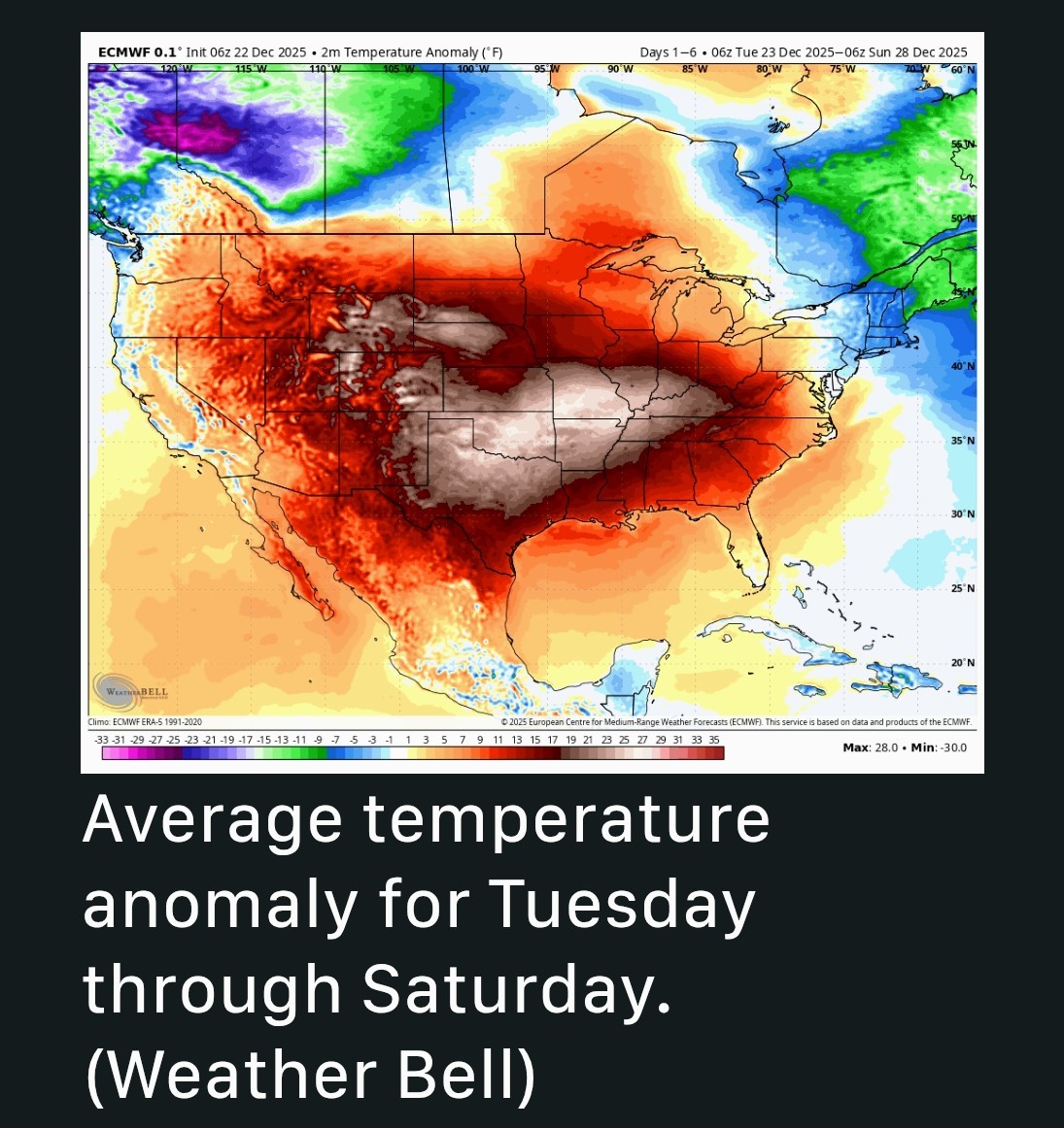 🎄 Along with the daytime warmth, we are going to experience dewpoints in the upper 60s to start the week, which is really, really sticky for this time of year.
🎄 These should drop slightly throughout the week, but for real relief, we are going to have to wait until Sunday, at least.
🎄 Due to generally light winds - and warm nights - we also are going to have a healthy chance of fog each morning, through Saturday. This is, unfortunately, an extremely high confidence forecast. MONDAY THROUGH FRIDAY - 🎄 There's no real sense in breaking out day-to-day forecasts, because not much is going to change in our sensible weather this week.
🎄 Each day will bring highs in the upper 70s to 80 degrees.
🎄 Daily record highs for this time of year range from 81 to 84 degrees, so we'll be keeping a close eye on those.
🎄 Nighttime lows will generally fall into the mid 60s in Houston, with conditions a little cooler inland, and a little warmer along the coast.
🎄 Days will be partly to mostly sunny, with more clouds at night.
🎄 Dense fog will be possible each morning.
🎄 Winds will be calm during the morning hours with a southerly breeze during the afternoon.  SATURDAY - 🎅 At this point, Saturday will probably be more or less a continuation of this week's weather.
🎅 A potent front is coming this weekend but at this point I think it will hold off until Sunday.
🎅 If the front accelerates, we might see some showers later on Saturday, but right now I'm doubtful. SUNDAY - 🎅 Some relief should finally arrive on Sunday, although the time is to be determined.
🎅 We may see some light showers with the front's passage but overall chances look to be fairly low.
🎅 Temperatures on Sunday will depend on the timing of the front but for now let's go with highs in the 70s. 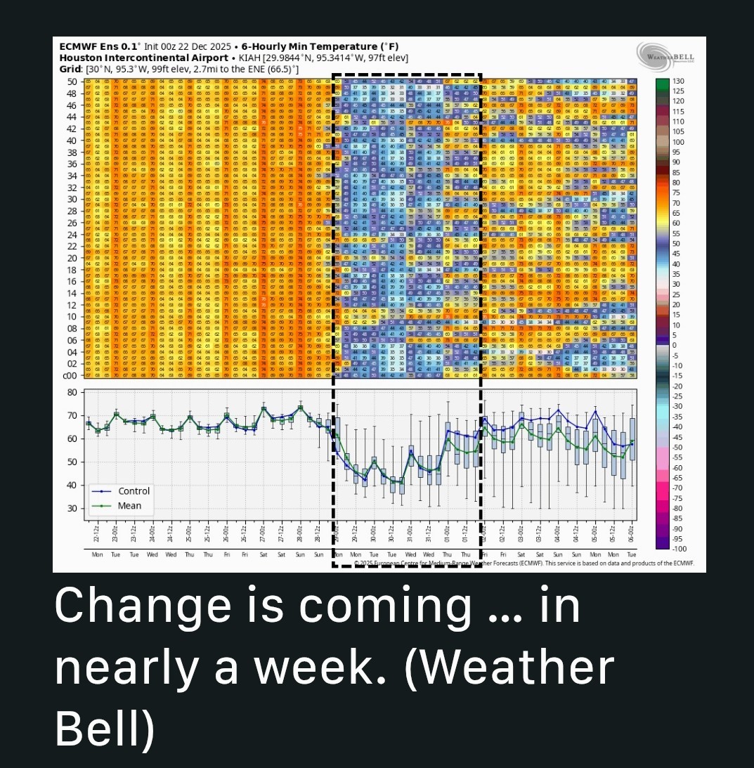 NEXT WEEK - 🥂🎉 Temperatures should drop back for several days next week.
🥂🎉 It's too early to have much precision, but beginning Monday we should see a few days with highs in the 60s and lows in the 40s, although it's possible we could get colder than that for a night or two.  NEW YEARS 🎉🥂🎆 🥂 As for New Year's Eve, we probably will be on a slight warming trend.


CatalinaKitKat, Ruger5 and peppermintstick + 2 more reacted 🎅 Highs near 80 & lows in the mid 60s
🎅 Partly to mostly sunny each day with humid & muggy conditions.
🎅 Dense fog likely each AM.
🎄 Light showers possible before a front arrives late Sunday.
📆 Temps get back to normal with lows in the 40s & highs in the 60s.
🥂 A warming trend is likely for NYE but it's still too soon to know the exact details.
🎄 If the unseasonable heat has you hot and bothered, we now have a pretty firm expiration date for our warm conditions.
🎄 High temperatures this week will likely reach 80 degrees every day through Saturday, or get very close to it, with nights in the mid-60s.
🎄 In terms of what is normal for this time of year, we are generally running about 15 degrees above where the December mercury usually resides.
🎄 As we have been saying for awhile now, a potent high pressure system has set up over the central United States; nearly the entire Lower 48 is going to see abnormally high temperatures during Christmas week.
🎄 These should drop slightly throughout the week, but for real relief, we are going to have to wait until Sunday, at least.
🎄 Due to generally light winds - and warm nights - we also are going to have a healthy chance of fog each morning, through Saturday. This is, unfortunately, an extremely high confidence forecast.
🎄 Each day will bring highs in the upper 70s to 80 degrees.
🎄 Daily record highs for this time of year range from 81 to 84 degrees, so we'll be keeping a close eye on those.
🎄 Nighttime lows will generally fall into the mid 60s in Houston, with conditions a little cooler inland, and a little warmer along the coast.
🎄 Days will be partly to mostly sunny, with more clouds at night.
🎄 Dense fog will be possible each morning.
🎄 Winds will be calm during the morning hours with a southerly breeze during the afternoon.
🎅 A potent front is coming this weekend but at this point I think it will hold off until Sunday.
🎅 If the front accelerates, we might see some showers later on Saturday, but right now I'm doubtful.
🎅 We may see some light showers with the front's passage but overall chances look to be fairly low.
🎅 Temperatures on Sunday will depend on the timing of the front but for now let's go with highs in the 70s.
🥂🎉 It's too early to have much precision, but beginning Monday we should see a few days with highs in the 60s and lows in the 40s, although it's possible we could get colder than that for a night or two.
Replies:

This week's forecast TODAY through FRIDAY: 🎅 Highs near 80 & lows in the mid 60s 🎅 Partly to mostly sunny each day with humid & muggy conditions. 🎅 Dense fog likely each AM. THE WEEKEND: 🎄 Light showers possible before a front arrives late Sunday. NEXT WEEK: 📆 Temps get back to normal with lows in the 40s & highs in the 60s. NEW YEARS: 🥂 A warming trend is likely for NYE but it's still too soon to know the exact details. ........................ From Space City Weather: It's beginning to feel NOT 🚫 like Christmas, everywhere you go.... In brief: 🎄 In this morning's post, we provide an update on our toasty weather for this week. 🎄 If the unseasonable heat has you hot and bothered, we now have a pretty firm expiration date for our warm conditions. Unseasonable seasons greetings 🔥🔥🔥 🎄 Well, here we are, a mere three days before Christmas Day. And instead of "ho, ho, ho" any visiting Santa Clauses are more likely to say, "hot, hot, hot!" (And who could blame them?) 🎄 High temperatures this week will likely reach 80 degrees every day through Saturday, or get very close to it, with nights in the mid-60s. 🎄 In terms of what is normal for this time of year, we are generally running about 15 degrees above where the December mercury usually resides. 🎄 As we have been saying for awhile now, a potent high pressure system has set up over the central United States; nearly the entire Lower 48 is going to see abnormally high temperatures during Christmas week. 🎄 Along with the daytime warmth, we are going to experience dewpoints in the upper 60s to start the week, which is really, really sticky for this time of year. 🎄 These should drop slightly throughout the week, but for real relief, we are going to have to wait until Sunday, at least. 🎄 Due to generally light winds - and warm nights - we also are going to have a healthy chance of fog each morning, through Saturday. This is, unfortunately, an extremely high confidence forecast. MONDAY THROUGH FRIDAY - 🎄 There's no real sense in breaking out day-to-day forecasts, because not much is going to change in our sensible weather this week. 🎄 Each day will bring highs in the upper 70s to 80 degrees. 🎄 Daily record highs for this time of year range from 81 to 84 degrees, so we'll be keeping a close eye on those. 🎄 Nighttime lows will generally fall into the mid 60s in Houston, with conditions a little cooler inland, and a little warmer along the coast. 🎄 Days will be partly to mostly sunny, with more clouds at night. 🎄 Dense fog will be possible each morning. 🎄 Winds will be calm during the morning hours with a southerly breeze during the afternoon. SATURDAY - 🎅 At this point, Saturday will probably be more or less a continuation of this week's weather. 🎅 A potent front is coming this weekend but at this point I think it will hold off until Sunday. 🎅 If the front accelerates, we might see some showers later on Saturday, but right now I'm doubtful. SUNDAY - 🎅 Some relief should finally arrive on Sunday, although the time is to be determined. 🎅 We may see some light showers with the front's passage but overall chances look to be fairly low. 🎅 Temperatures on Sunday will depend on the timing of the front but for now let's go with highs in the 70s. NEXT WEEK - 🥂🎉 Temperatures should drop back for several days next week. 🥂🎉 It's too early to have much precision, but beginning Monday we should see a few days with highs in the 60s and lows in the 40s, although it's possible we could get colder than that for a night or two. NEW YEARS 🎉🥂🎆 🥂 As for New Year's Eve, we probably will be on a slight warming trend.
StormChaser : Love the pic of Santa on the beach!!! « Back to Chat
Views: 279
# Replies: 3