


This week's forecast
This week's forecast


Joined:
X days ago
# Posts:
X,XXX
Contributor Points:
X


This week's forecast December is here and so is the cold.....and rain. 🥶☔️ By weeks end, we could pick up and additional 4" of rain. (On top of there 2.5" we picked up over the weekend) MONDAY: Rainy & highs in the 40s.
TUESDAY: Sunny skies return with highs in the 50s.
WEDNESDAY EVENING THROUGH FRIDAY MORNING: Rain returns with highs in the 60s.
WEEKEND: Sunny & warm with highs near 70° ................ From Space City Weather: Monday will be cold, wet, and dreary in Houston, followed by the potential for plenty more rain later this week. Eric Berger · Monday, December 1, 2025 7:07 AM In brief: *The word for today is dreary, as we are going to see a wet and cold day in Houston.
*Sunshine briefly returns on Tuesday before a rainy end to the work week.
*Some areas, all told, may pick up 4 or more inches of rain through Friday. Also, our annual fundraiser ends later today! Flipping the switch on rain - *In Sunday's post I noted that our overall weather pattern had seemingly flipped the script, over night, from an exceedingly dry one to widespread rainfall.
*Indeed it is possible that, starting with yesterday's rains, our region will receive more total rainfall this week than it did during the previous 90 days.
*We have another round of widespread showers today, and then again from Wednesday afternoon through Friday.
*This should nicely dent our burgeoning drought.
*If you're already tired of the gray and rainy weather, it does appear that by the coming weekend we'll see a stretch of sunnier weather. 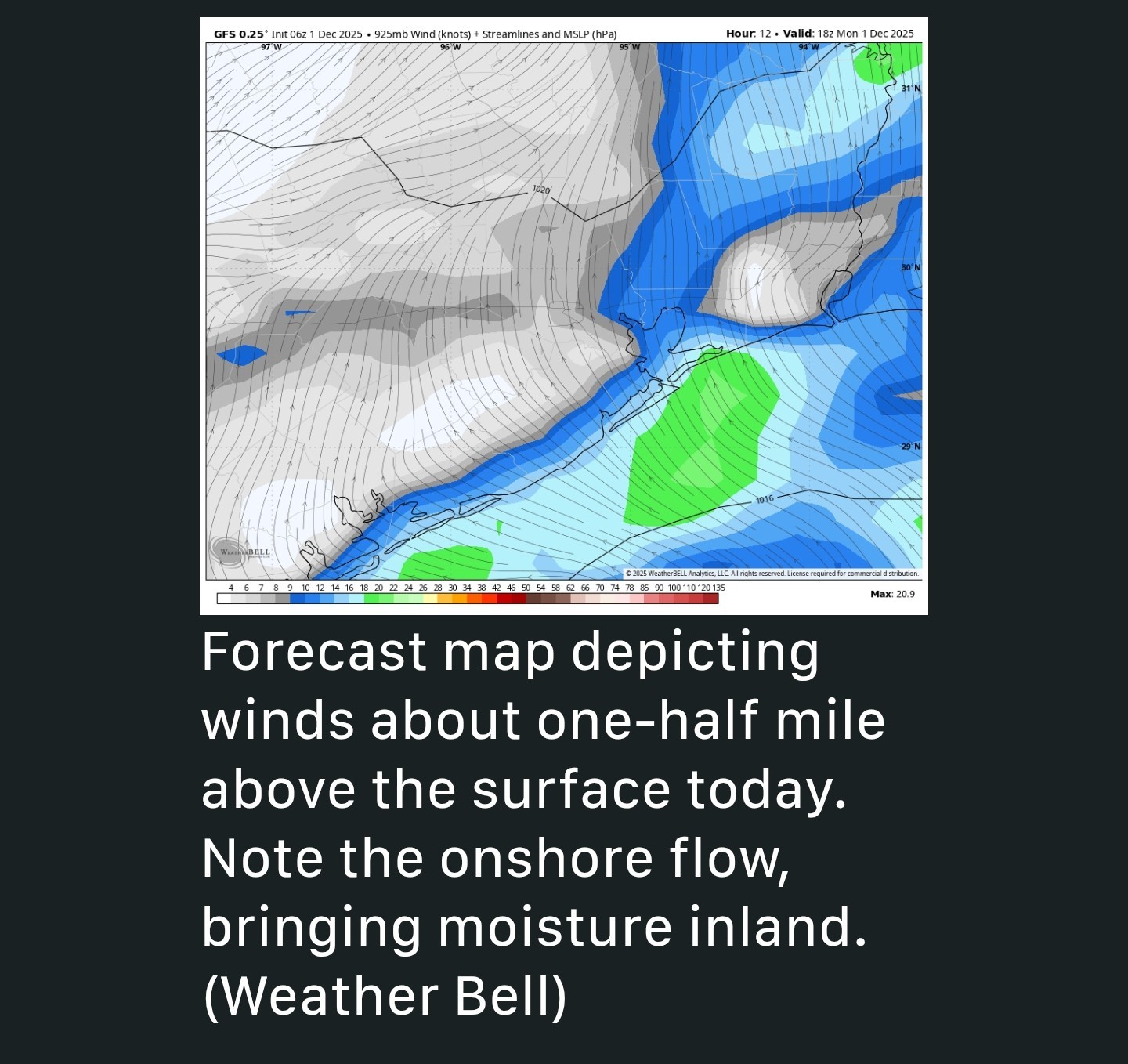 MONDAY - 🥶⚡️☔️ *Today we're going to see cold rain, especially for Harris County and points south.
*Pre-sunrise we are already seeing light to moderate showers across much of the region, with additional showers building to the southwest as a disturbance propagates into the area.
*One question you may ask is, where is the moisture coming from if winds at the surface are cold and dry from the north? Well, not too far above the surface the flow is more southerly, allowing for an onshore flow overrunning the air at the surface. Thus there is plentiful moisture at about one-half mile and above, where clouds are forming.
*Although rain totals will vary widely today, you can probably expect somewhere between 0.5 and 2.5 inches.
*The showers should finally clear to the northeast by late this afternoon or evening. 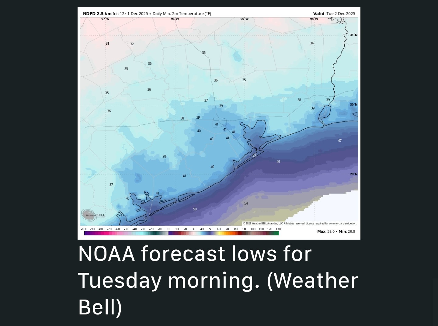 *The other major story of the day is going to be the cold air. Some parts of Houston may not get out of the upper 40s today.
*Our low temperatures tonight will be dependent upon whether we see clearing skies by the wee hours of Tuesday; fairly gusty winds from the north will provide less than ideal cooling conditions.
*As a result, I think even the inland portions of our region will escape a freeze, but for some locations in northern Montgomery County it may be close. TUESDAY - 🌞 If you're a sunshine person, today's the day. *Expect mostly sunny skies and no rain on Tuesday.
*An ongoing, chilly flow from the north will keep highs confined to the mid-50s.
*Skies turn partly cloudy on Tuesday night, which should see lows near where they were Monday night, but perhaps a degree or two warmer. So another quite cold night. WEDNESDAY, THURSDAY, OUR FRIDAY - ☔️⚡️⛈️ *Our next weather system arrives later on Wednesday, and this will set the stage for another rainy period from Wednesday evening through Friday morning.
*Highs on Wednesday may reach the upper 60s, with partly to mostly cloudy skies.
*The day should be mostly rain free, at least until the afternoon or evening.
*After this, we should see plenty of rain showers from Wednesday night through Friday morning.
*It won't be wall to wall storms, but we can expect accumulations of perhaps 1 to 3 inches area wide, with greater totals near the coast.
*I don't think this will be enough to cause flooding conditions. We'll watch things closely, however.
*A colder air mass will slowly sag into the region such that, by Friday, highs may only reach 60 degrees. 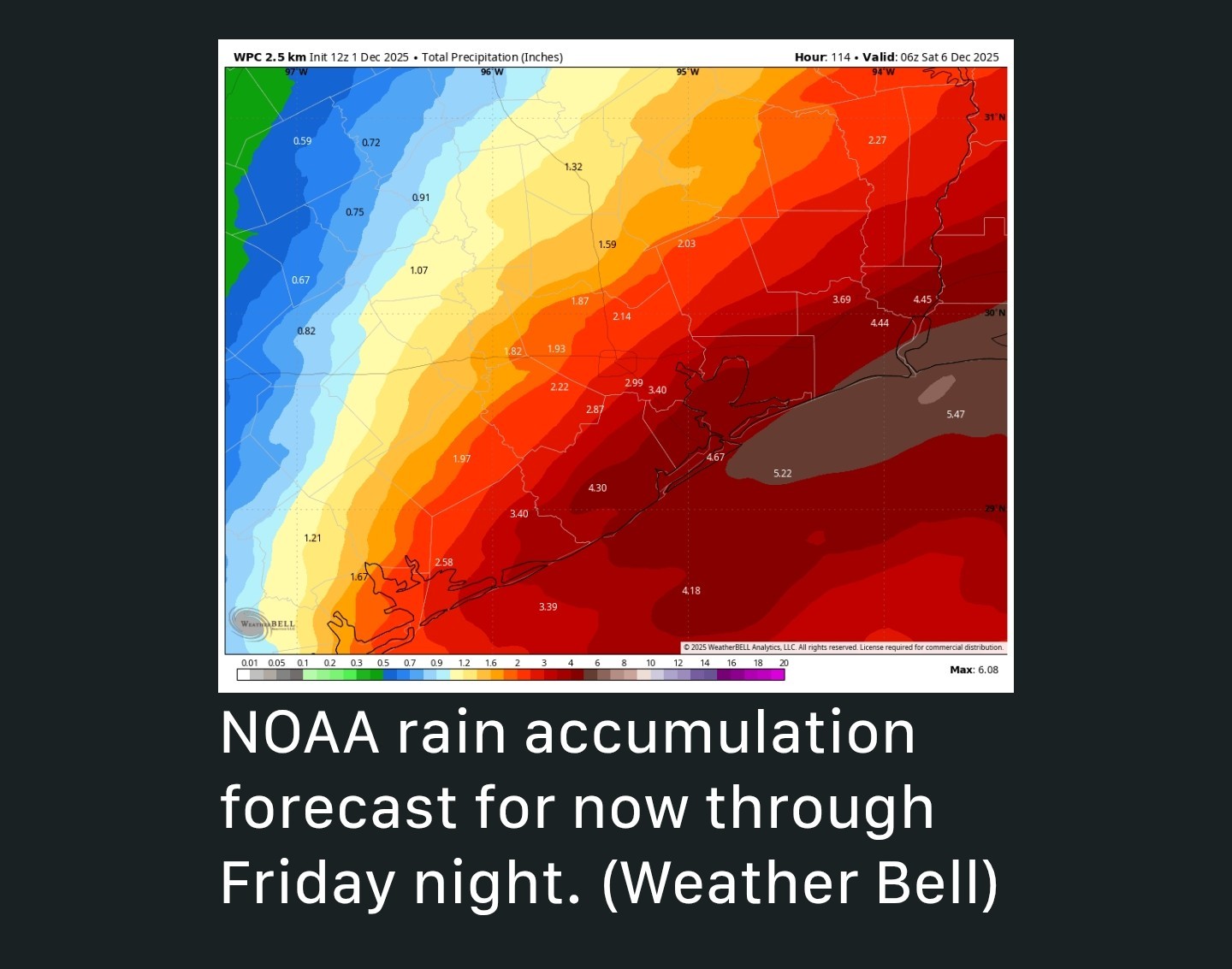 SATURDAY AND SUNDAY - 🌞🌡 *The upside of the rain this week is that, by the weekend, conditions should be a fair bit nicer.
*For now, I expect partly to mostly sunny skies on Saturday and Sunday, with highs perhaps in the upper 60s to lower 70s.
*If you have outdoor plans this weekend things should be pretty nice!
*I expect the mostly sunny skies and low rain chances to persist at least into the middle of next week.
CatalinaKitKat and bigla reacted TUESDAY: Sunny skies return with highs in the 50s.
WEDNESDAY EVENING THROUGH FRIDAY MORNING: Rain returns with highs in the 60s.
WEEKEND: Sunny & warm with highs near 70°
*Sunshine briefly returns on Tuesday before a rainy end to the work week.
*Some areas, all told, may pick up 4 or more inches of rain through Friday.
*Indeed it is possible that, starting with yesterday's rains, our region will receive more total rainfall this week than it did during the previous 90 days.
*We have another round of widespread showers today, and then again from Wednesday afternoon through Friday.
*This should nicely dent our burgeoning drought.
*If you're already tired of the gray and rainy weather, it does appear that by the coming weekend we'll see a stretch of sunnier weather.
*Pre-sunrise we are already seeing light to moderate showers across much of the region, with additional showers building to the southwest as a disturbance propagates into the area.
*One question you may ask is, where is the moisture coming from if winds at the surface are cold and dry from the north? Well, not too far above the surface the flow is more southerly, allowing for an onshore flow overrunning the air at the surface. Thus there is plentiful moisture at about one-half mile and above, where clouds are forming.
*Although rain totals will vary widely today, you can probably expect somewhere between 0.5 and 2.5 inches.
*The showers should finally clear to the northeast by late this afternoon or evening.
*Our low temperatures tonight will be dependent upon whether we see clearing skies by the wee hours of Tuesday; fairly gusty winds from the north will provide less than ideal cooling conditions.
*As a result, I think even the inland portions of our region will escape a freeze, but for some locations in northern Montgomery County it may be close.
*An ongoing, chilly flow from the north will keep highs confined to the mid-50s.
*Skies turn partly cloudy on Tuesday night, which should see lows near where they were Monday night, but perhaps a degree or two warmer.
*Highs on Wednesday may reach the upper 60s, with partly to mostly cloudy skies.
*The day should be mostly rain free, at least until the afternoon or evening.
*After this, we should see plenty of rain showers from Wednesday night through Friday morning.
*It won't be wall to wall storms, but we can expect accumulations of perhaps 1 to 3 inches area wide, with greater totals near the coast.
*I don't think this will be enough to cause flooding conditions. We'll watch things closely, however.
*A colder air mass will slowly sag into the region such that, by Friday, highs may only reach 60 degrees.
*For now, I expect partly to mostly sunny skies on Saturday and Sunday, with highs perhaps in the upper 60s to lower 70s.
*If you have outdoor plans this weekend things should be pretty nice!
*I expect the mostly sunny skies and low rain chances to persist at least into the middle of next week.