


This week's forecast
This week's forecast


Joined:
X days ago
# Posts:
X,XXX
Contributor Points:
X


This week's forecast ✳️ The first half of this week is going to be really cold by early December standards, and we are going to see ongoing rain chances for the remainder of the week. ✳️ Cold weather is here. 🥶
✳️ Monday (tomorrow) is cold all day (low 50s) with AM storms; 1-2" of additional rainfall possible (on top of the 2.25" we received this AM)
✳️ Wednesday starts in the 30s but we avoid a freeze; temps warm into the 60s by afternoon.
✳️ Another storm system arrives on Thursday, bringing more rain chances to end the work week.
✳️ Chillier temps return by Friday or Saturday morning, with lows in the 40s & highs in the 60s.
.................. From Space City Weather: After a very warm and dry fall, Houston's pattern changed overnight. Eric Berger · Sunday, November 30, 2025 8:24 AM In brief: *We're posting on Sunday because of the significant (and mostly welcome) overnight rains, which have ushered in a much colder air mass.
*This marks a big change from the fall weather which has come before. In short, winter has come to Houston a day early. End of fall pattern change 🤎 *Pretty much everyone reading this probably realizes that Houston has had a warm and dry fall.
*Our daily maximum temperatures have regularly flirted with record highs, and due to a paucity of rain the region has slipped into a moderate-to-severe drought after remaining drought free during the summer months.
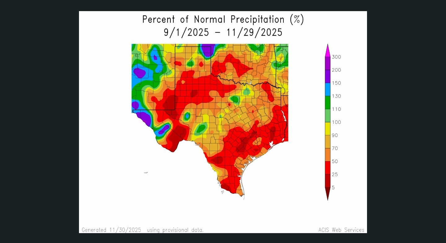
*For the months of September, October, and November our high temperatures have run, on average, 4 to 6 degrees above normal in the Houston region, and indeed across much of Texas. Here's what that looks like graphically: 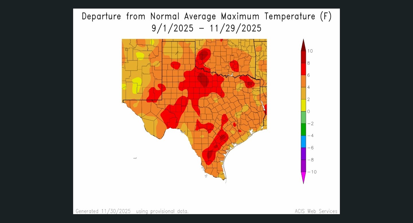 The story is much the same for precipitation this fall. Most of the eastern part of Texas has received just 25 to 50 percent of normal levels of rainfall. (Where I live, the grass has turned crispy and brown, and before Saturday night I had not seen any precipitation in nearly five weeks. This has been the driest fall I can recall, having lived here for nearly three decades)
  All of this makes Saturday night's front SO significant. 💙 *Without too much in the way of severe weather it brought a solid 2 to 4 inches of rainfall to most of the metro area (Katy and western areas, excepted).
*This is the first time in many weeks that a storm system has over-performed model expectations for precipitation. 👍
*All of this points to a pattern change, and indeed that is what the near-term forecast holds. The first half of this week is going to be really cold by early December standards, and we are going to see ongoing rain chances for the remainder of the week. SUNDAY - 🥶 *As of shortly after sunrise, temperatures for much of Houston are in the mid-50s, and they're likely to only fall from here.
*Some additional very light showers are possible today, but for the most part I expect skies to just be gray.
*Winds will be gusty, from the north up to 25 mph. So very chilly out.
*Lows tonight will drop into the 40s for most of the metro area. MONDAY - ⛈️🥶 *Rains are back on the menu for Monday. Around day break we should see a system move in from the southwest.
*Rain chances and accumulations will likely be highest for coastal counties, to the south and east of Highway 59/Interstate 69.
*I think 1-2 inches will be the upper limit for coastal areas, with inland locations seeing significantly less.
*In terms of temperatures, it's going to be cold. I expect highs to peak in the low to mid-50s.
*Expect another chilly night in the 40s in Houston as rains end. 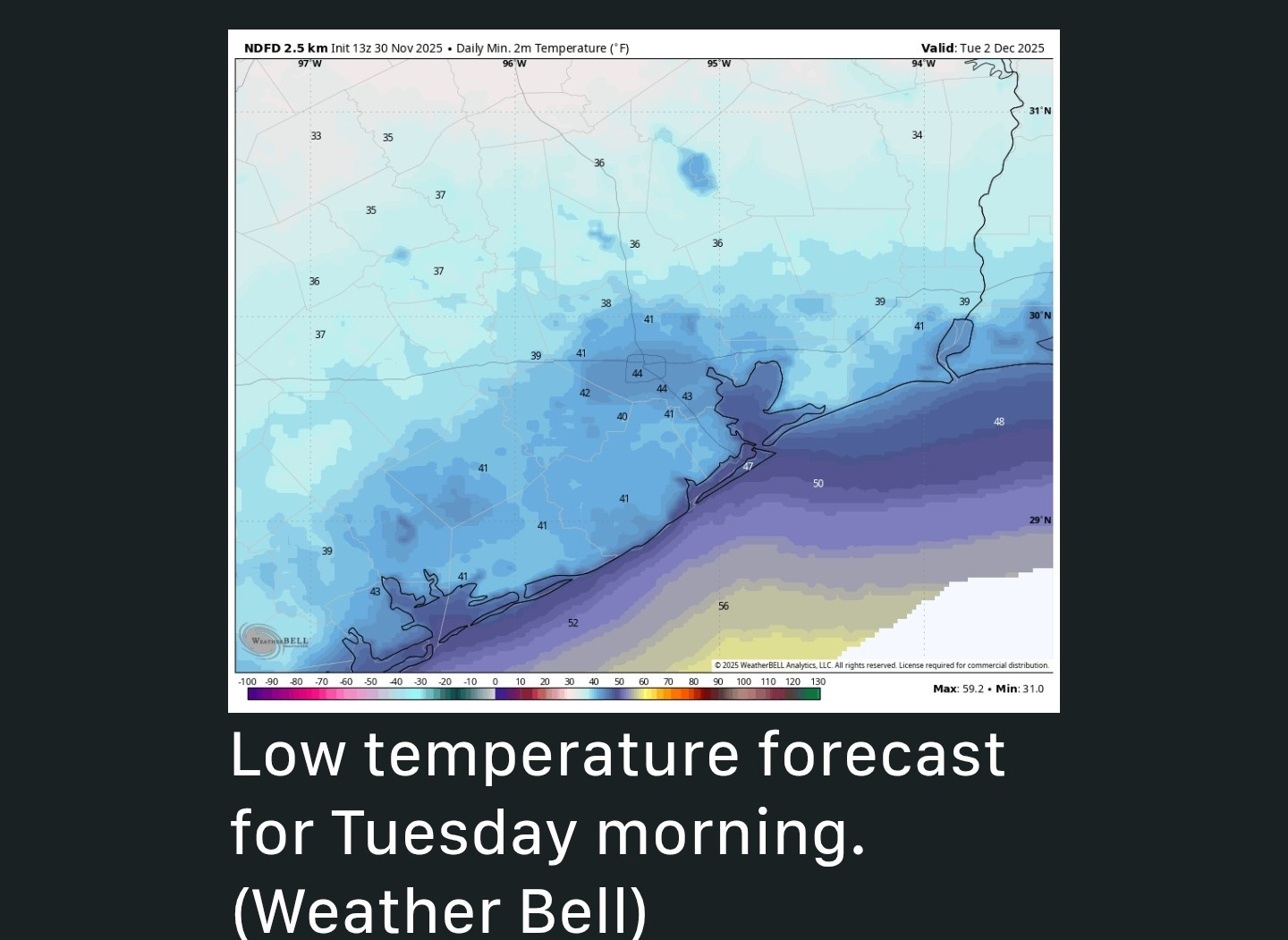 TUESDAY - 🥶🌞 *This will be a sunny and cold day, with highs in the upper 50s.
*With partly clear skies we should see ideal cooling on Tuesday night, with temperatures in the 30s north of Houston.
*I think the greater Houston region escapes a freeze. THE REST OF THE WEEK - 🥶⛈️🌞 *Highs will warm into the 60s on Wednesday with some clouds.
*Another storm system arrives later in the week, likely on Thursday, bringing elevated rain chances to end the work week.
*Chillier temperatures could return by Friday or Saturday morning, with lows in the 40s.


cbear, Babieborris and Gammyof2 reacted ✳️ Monday (tomorrow) is cold all day (low 50s) with AM storms; 1-2" of additional rainfall possible (on top of the 2.25" we received this AM)
✳️ Wednesday starts in the 30s but we avoid a freeze; temps warm into the 60s by afternoon.
✳️ Another storm system arrives on Thursday, bringing more rain chances to end the work week.
✳️ Chillier temps return by Friday or Saturday morning, with lows in the 40s & highs in the 60s.
..................
*This marks a big change from the fall weather which has come before. In short, winter has come to Houston a day early.
*Our daily maximum temperatures have regularly flirted with record highs, and due to a paucity of rain the region has slipped into a moderate-to-severe drought after remaining drought free during the summer months.
*For the months of September, October, and November our high temperatures have run, on average, 4 to 6 degrees above normal in the Houston region, and indeed across much of Texas.
*This is the first time in many weeks that a storm system has over-performed model expectations for precipitation. 👍
*All of this points to a pattern change, and indeed that is what the near-term forecast holds.
*Some additional very light showers are possible today, but for the most part I expect skies to just be gray.
*Winds will be gusty, from the north up to 25 mph. So very chilly out.
*Lows tonight will drop into the 40s for most of the metro area.
*Rain chances and accumulations will likely be highest for coastal counties, to the south and east of Highway 59/Interstate 69.
*I think 1-2 inches will be the upper limit for coastal areas, with inland locations seeing significantly less.
*In terms of temperatures, it's going to be cold. I expect highs to peak in the low to mid-50s.
*Expect another chilly night in the 40s in Houston as rains end.
*With partly clear skies we should see ideal cooling on Tuesday night, with temperatures in the 30s north of Houston.
*I think the greater Houston region escapes a freeze.
*Another storm system arrives later in the week, likely on Thursday, bringing elevated rain chances to end the work week.
*Chillier temperatures could return by Friday or Saturday morning, with lows in the 40s.
Replies:
StormChaser : thanks for the information. I'd love for the seasonal temperatures to stick around for a while.
This week's forecast ✳️ The first half of this week is going to be really cold by early December standards, and we are going to see ongoing rain chances for the remainder of the week. ✳️ Cold weather is here. 🥶 ✳️ Monday (tomorrow) is cold all day (low 50s) with AM storms; 1-2" of additional rainfall possible (on top of the 2.25" we received this AM) ✳️ Wednesday starts in the 30s but we avoid a freeze; temps warm into the 60s by afternoon. ✳️ Another storm system arrives on Thursday, bringing more rain chances to end the work week. ✳️ Chillier temps return by Friday or Saturday morning, with lows in the 40s & highs in the 60s. .................. From Space City Weather: After a very warm and dry fall, Houston's pattern changed overnight. Eric Berger · Sunday, November 30, 2025 8:24 AM In brief: *We're posting on Sunday because of the significant (and mostly welcome) overnight rains, which have ushered in a much colder air mass. *This marks a big change from the fall weather which has come before. In short, winter has come to Houston a day early. End of fall pattern change 🤎 *Pretty much everyone reading this probably realizes that Houston has had a warm and dry fall. *Our daily maximum temperatures have regularly flirted with record highs, and due to a paucity of rain the region has slipped into a moderate-to-severe drought after remaining drought free during the summer months. *For the months of September, October, and November our high temperatures have run, on average, 4 to 6 degrees above normal in the Houston region, and indeed across much of Texas. Here's what that looks like graphically: The story is much the same for precipitation this fall. Most of the eastern part of Texas has received just 25 to 50 percent of normal levels of rainfall. (Where I live, the grass has turned crispy and brown, and before Saturday night I had not seen any precipitation in nearly five weeks. This has been the driest fall I can recall, having lived here for nearly three decades) All of this makes Saturday night's front SO significant. 💙 *Without too much in the way of severe weather it brought a solid 2 to 4 inches of rainfall to most of the metro area (Katy and western areas, excepted). *This is the first time in many weeks that a storm system has over-performed model expectations for precipitation. 👍 *All of this points to a pattern change, and indeed that is what the near-term forecast holds. The first half of this week is going to be really cold by early December standards, and we are going to see ongoing rain chances for the remainder of the week. SUNDAY - 🥶 *As of shortly after sunrise, temperatures for much of Houston are in the mid-50s, and they're likely to only fall from here. *Some additional very light showers are possible today, but for the most part I expect skies to just be gray. *Winds will be gusty, from the north up to 25 mph. So very chilly out. *Lows tonight will drop into the 40s for most of the metro area. MONDAY - ⛈️🥶 *Rains are back on the menu for Monday. Around day break we should see a system move in from the southwest. *Rain chances and accumulations will likely be highest for coastal counties, to the south and east of Highway 59/Interstate 69. *I think 1-2 inches will be the upper limit for coastal areas, with inland locations seeing significantly less. *In terms of temperatures, it's going to be cold. I expect highs to peak in the low to mid-50s. *Expect another chilly night in the 40s in Houston as rains end. TUESDAY - 🥶🌞 *This will be a sunny and cold day, with highs in the upper 50s. *With partly clear skies we should see ideal cooling on Tuesday night, with temperatures in the 30s north of Houston. *I think the greater Houston region escapes a freeze. THE REST OF THE WEEK - 🥶⛈️🌞 *Highs will warm into the 60s on Wednesday with some clouds. *Another storm system arrives later in the week, likely on Thursday, bringing elevated rain chances to end the work week. *Chillier temperatures could return by Friday or Saturday morning, with lows in the 40s.
StormChaser : I wonder if by the end of this week, will we be caught up and out of the drought?
StormChaser : I wonder if by the end of this week, will we be caught up and out of the drought?
cbear : Not quite but it's certainly helping.
cbear : Not quite but it's certainly helping.
StormChaser : Agreed. I hope for a more balanced weather pattern for 2026. « Back to Chat
Views: 226
# Replies: 4