


This week's forecast
This week's forecast


Joined:
X days ago
# Posts:
X,XXX
Contributor Points:
X


This week's forecast ➡️ Our forecast hints of a cold front in about 10-12 days that is stronger than the 2 fronts we've seen this year. (Think: 50s in the AM and 80s during the day)
➡️ The cooler temps will be welcome, for sure.
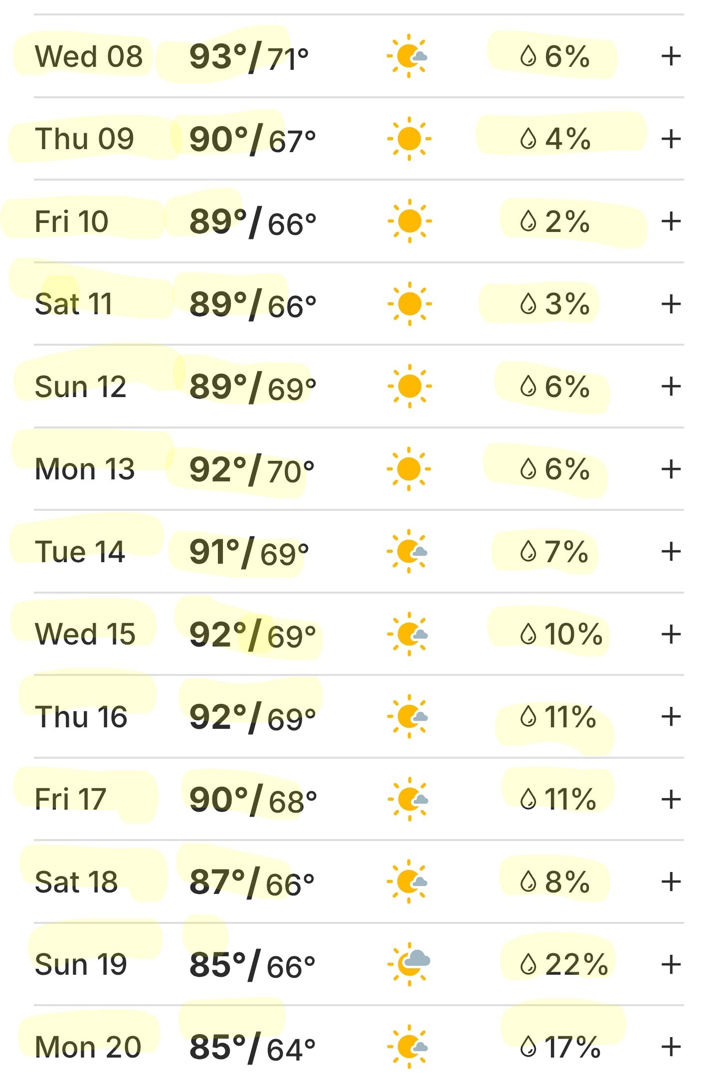
➡️ The issue I see is in all this is that we basically have ZERO rain chances during the entire period leading up to said front. (10-12 days from now) 💦🚫
➡️ Also, the precip forecast totals for the front look low right now. ➡️ In other words: its going to be hot & dry. 🌧🚫🔥🥵 ➡️ We do have 20% sea breeze rain chances over the next 3 days so maybe we'll get lucky and see some rainfall with that. 🤞 .............................. From Space City Weather- Eric Berger · Monday, October 6, 2025 6:55 AM In brief: *Houston's late summer heat will continue this week, but a modest front should bring some drier air by Thursday or Friday.
*We have a chance of a stronger front in a little more than 10 days, but no promises MONDAY - *Our late summer-like weather will continue for much of this week before some kind of front, probably fairly weak, arrives by Thursday or Friday.
*Until such time, our weather will largely be driven by high pressure.
*For Monday, that means high temperatures of about 90 degrees in the city of Houston with higher temperatures to the west and north.
*Winds will be light & generally from the east to northeast.
*Skies will be mostly sunny.
*Overnight lows will be sultry with a dewpoint of around 70 degrees - incredibly sticky, especially for October. TUESDAY AND WEDNESDAY - *These will be the warmest days of the week, with high temperatures likely in the lower 90s in Houston & mid-90s for far inland areas.
*I don't think we will quite get to record highs in Houston (95 degrees on Tuesday, and 96 on Wednesday, but we're going to get close).
*Rain chances will be low, perhaps 20 percent each day along the sea breeze.
*This doesn't look like much but it may offer our region's best chance of rain for the next 10 days. 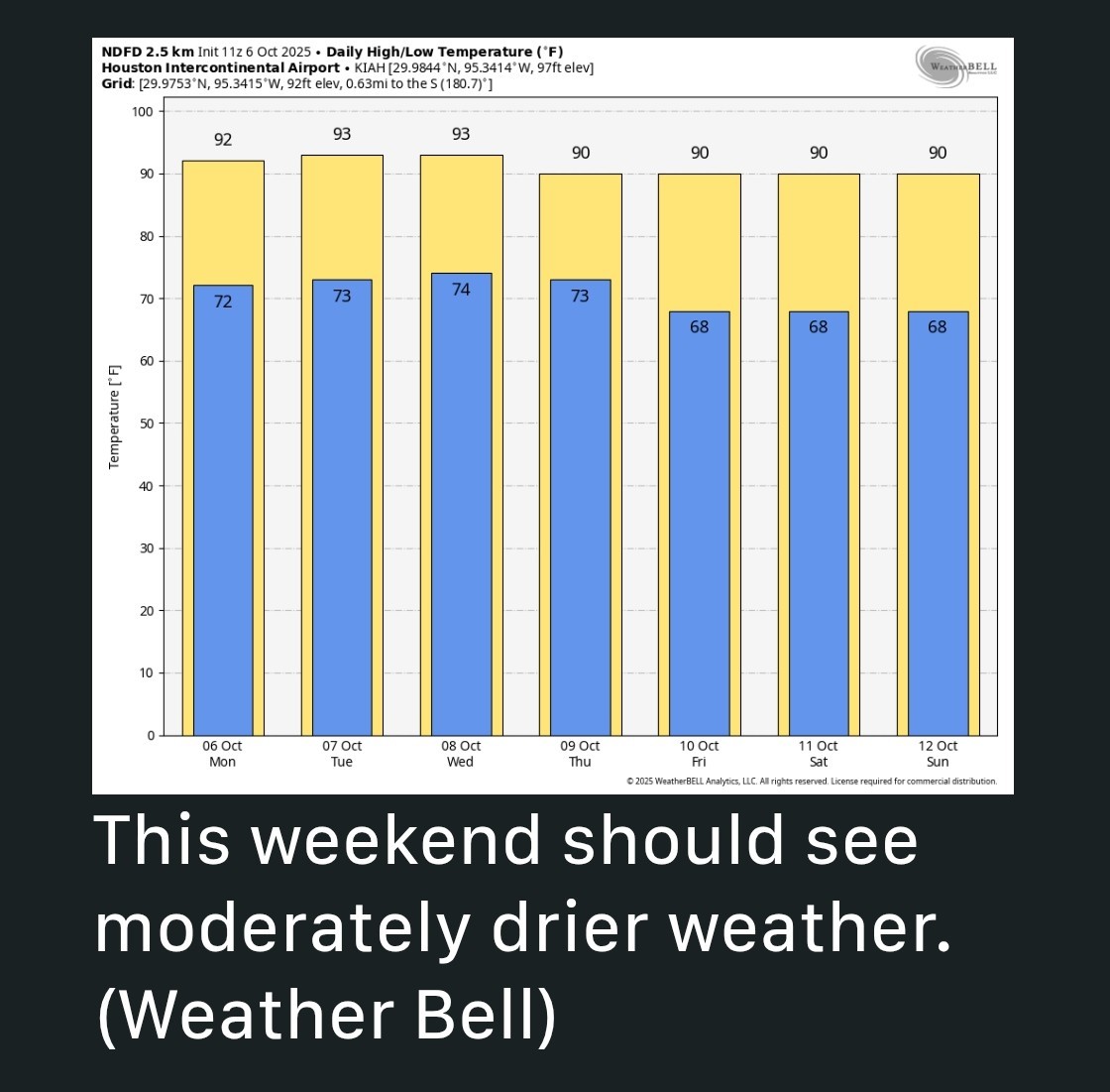 THURSDAY AND FRIDAY - *By Thursday, drier air should start to work its way into Houston.
*This will lead to high temperatures of around 90 degrees with lows in the upper 60s.
*Sunny skies prevail. SATURDAY AND SUNDAY - *Expect more of the same for the weekend with sunny skies & highs of around 90 degrees.
*Dewpoints look to be a bit lower in the 60s, so while it will be warm, it won't feel like full-on summer.
*Rain chances remain low to non-existent. NEXT WEEK - The headline of this weather update promised "hints" of cooler weather. We are going to get some of that this weekend with a weak front. Well, most of next week should bring continued highs of around 90 degrees. However, toward the end of next week I *do* think we have a decent chance of seeing a stronger front. I'm not ready to write this in ink for a variety of reasons, such as it being 10 to 12 days out, and our late summer heat has been pretty persistent. But I do think fall has a pretty OK chance of breaking out late next week. Daily rain chances from now until until 20th: 🚫


Rocketgirl13, Aggie89 and sebastian2 + 3 more reacted ➡️ The cooler temps will be welcome, for sure.
➡️ The issue I see is in all this is that we basically have ZERO rain chances during the entire period leading up to said front. (10-12 days from now) 💦🚫
➡️ Also, the precip forecast totals for the front look low right now.
*We have a chance of a stronger front in a little more than 10 days, but no promises
*Until such time, our weather will largely be driven by high pressure.
*For Monday, that means high temperatures of about 90 degrees in the city of Houston with higher temperatures to the west and north.
*Winds will be light & generally from the east to northeast.
*Skies will be mostly sunny.
*Overnight lows will be sultry with a dewpoint of around 70 degrees - incredibly sticky, especially for October.
*I don't think we will quite get to record highs in Houston (95 degrees on Tuesday, and 96 on Wednesday, but we're going to get close).
*Rain chances will be low, perhaps 20 percent each day along the sea breeze.
*This doesn't look like much but it may offer our region's best chance of rain for the next 10 days.
*This will lead to high temperatures of around 90 degrees with lows in the upper 60s.
*Sunny skies prevail.
*Dewpoints look to be a bit lower in the 60s, so while it will be warm, it won't feel like full-on summer.
*Rain chances remain low to non-existent.
Replies:
StormChaser : Looking forward to cooler and praying for rain.
This week's forecast ➡️ Our forecast hints of a cold front in about 10-12 days that is stronger than the 2 fronts we've seen this year. (Think: 50s in the AM and 80s during the day) ➡️ The cooler temps will be welcome, for sure. ➡️ The issue I see is in all this is that we basically have ZERO rain chances during the entire period leading up to said front. (10-12 days from now) 💦🚫 ➡️ Also, the precip forecast totals for the front look low right now. ➡️ In other words: its going to be hot & dry. 🌧🚫🔥🥵 ➡️ We do have 20% sea breeze rain chances over the next 3 days so maybe we'll get lucky and see some rainfall with that. 🤞 .............................. From Space City Weather- Eric Berger · Monday, October 6, 2025 6:55 AM In brief: *Houston's late summer heat will continue this week, but a modest front should bring some drier air by Thursday or Friday. *We have a chance of a stronger front in a little more than 10 days, but no promises MONDAY - *Our late summer-like weather will continue for much of this week before some kind of front, probably fairly weak, arrives by Thursday or Friday. *Until such time, our weather will largely be driven by high pressure. *For Monday, that means high temperatures of about 90 degrees in the city of Houston with higher temperatures to the west and north. *Winds will be light & generally from the east to northeast. *Skies will be mostly sunny. *Overnight lows will be sultry with a dewpoint of around 70 degrees - incredibly sticky, especially for October. TUESDAY AND WEDNESDAY - *These will be the warmest days of the week, with high temperatures likely in the lower 90s in Houston & mid-90s for far inland areas. *I don't think we will quite get to record highs in Houston (95 degrees on Tuesday, and 96 on Wednesday, but we're going to get close). *Rain chances will be low, perhaps 20 percent each day along the sea breeze. *This doesn't look like much but it may offer our region's best chance of rain for the next 10 days. THURSDAY AND FRIDAY - *By Thursday, drier air should start to work its way into Houston. *This will lead to high temperatures of around 90 degrees with lows in the upper 60s. *Sunny skies prevail. SATURDAY AND SUNDAY - *Expect more of the same for the weekend with sunny skies & highs of around 90 degrees. *Dewpoints look to be a bit lower in the 60s, so while it will be warm, it won't feel like full-on summer. *Rain chances remain low to non-existent. NEXT WEEK - The headline of this weather update promised "hints" of cooler weather. We are going to get some of that this weekend with a weak front. Well, most of next week should bring continued highs of around 90 degrees. However, toward the end of next week I *do* think we have a decent chance of seeing a stronger front. I'm not ready to write this in ink for a variety of reasons, such as it being 10 to 12 days out, and our late summer heat has been pretty persistent. But I do think fall has a pretty OK chance of breaking out late next week. Daily rain chances from now until until 20th: 🚫
StormChaser : what happened to our lovely mild summer with (up through July at least) decent rainfall?? 😢😢
To me this was the perfect summer since no canes were a worry for us!
Lulu45, Kittle and Aggie89 + 1 more reacted
To me this was the perfect summer since no canes were a worry for us!
mutton : Bingo. Plus it wasn't that hot! I'll take warmer temps into October as a trade off!
mutton : Bingo. Plus it wasn't that hot! I'll take warmer temps into October as a trade off!
StormChaser : Amen to that! Lol
StormChaser : Rain is seriously needed. Cooler temperatures would be nice but no hurricanes is nicer.
« Back to Chat
Views: 295
# Replies: 7