


This week's forecast (storms likely tonight)
This week's forecast (storms likely tonight)


Joined:
X days ago
# Posts:
X,XXX
Contributor Points:
X


This week's forecast (storms likely tonight) - Scattered showers today before severe storms roll in tonight after 7pm.
- The biggest threat with tonight's storms will be damaging winds and hail.
- Expect watches to be issued this evening.
- Tuesday is warm & sunny.
- Wednesday is cooler & sunny.
- Thanksgiving will be sunny with highs in the low 60s. 🦃
- Showers & warm weather return for the weekend.
- Stronger front next week drops temps to seasonal norm. .......... From Space City Weather: Thunderstorms possible this evening ahead of a Thanksgiving that will be as nice as pie. Eric Berger · Monday, November 24, 2025 6:50 AM In brief: *In today's post we talk about the potential for storms this evening in Houston as a weak front sags into the area.
*A second push of colder air will make things feel festive on Thanksgiving Day.
*We'll see the return of a moderately warmer pattern with higher rain chances this coming weekend. 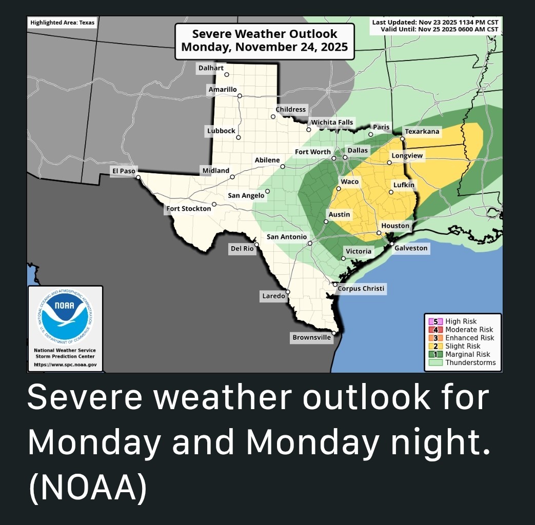 MONDAY (TODAY) *Our brief foray with cooler fall weather on Sunday has ended, with this weekend's front moving back onshore as a warm front overnight.
*Winds this morning are light, from the southeast, with temperatures around 70 degrees.
*Accordingly, today will be rather warm, with highs in the low 80s despite mostly cloudy skies.
*We are going to see scattered (mostly light) showers during the daytime along with very humid air. 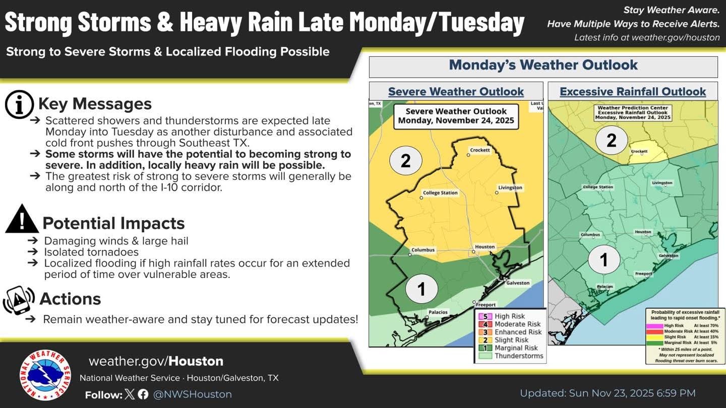 *By this evening, likely around 7 to 9 pm, a broken line of storms associated with a cold front will develop to the northwest of Houston. This line will slowly advance into the city during the late evening hours, and push off the coast after midnight.
*Damaging winds will be possible with this front, perhaps gusting up to 50 mph, with potentially some hail.
*Overall rain accumulations will vary widely, but most of us should pick up between 0.25 and 0.75 inch. 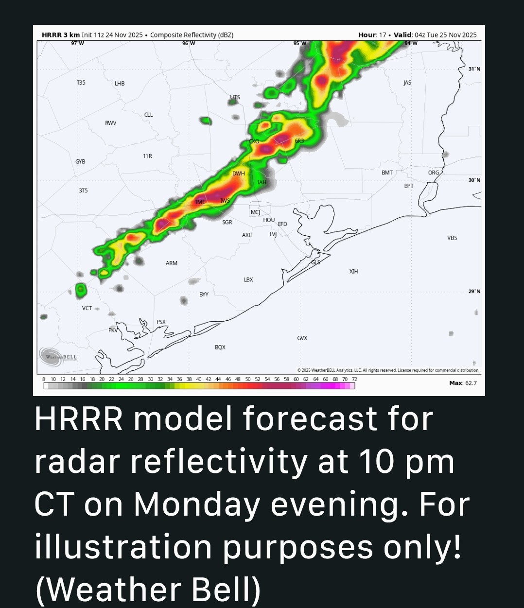 TUESDAY - *The initial push of cooler air with with this front will be fairly weak.
*As a result I expect highs of around 80 degrees on Tuesday, with mostly sunny skies and lower humidity.
*Low temperatures on Tuesday night should drop into the 50s. WEDNESDAY - *A secondary push of colder air arrives overnight, into Wednesday morning, and this will result in breezier northerly conditions.
*Winds may gust out of the north up to 20 mph on Wednesday.
*Expect sunny skies and highs in the upper 60s.
*Lows on Wednesday night will drop into the upper 40s in Houston, with cooler conditions for inland areas. 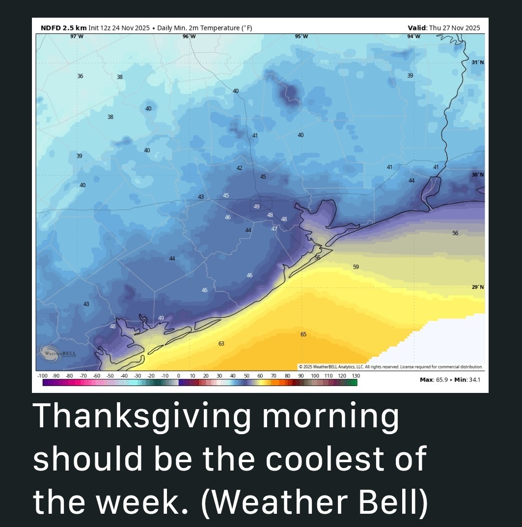 THANKSGIVING - *We'll start the day clear and cool, and skies will be sunny throughout the day.
*Really, we have no weather concerns, with light winds expected and highs generally in the upper 60s.
*Lows on Thursday night will drop to around 50 degrees with cooler conditions for inland areas. FRIDAY, SATURDAY, and SUNDAY - *The onshore flow resumes on Friday, and we are going to enter a period of mostly cloudy skies and increased rain chances by Saturday morning.
*High temperatures through Sunday should be in the low- to mid-70s, with modestly increasing humidity levels.
*Overall I think the area will pick up 1 to 2 inches of rainfall on Saturday and Sunday.
*If you have outdoor plans we'll keep a close eye on the forecast for you. At this point I think showers will be intermittent rather than wall-to-wall, but we don't have a good handle on the details yet. NEXT WEEK - *At some point - perhaps on Monday - a stronger front should push into the region. This is likely to bring some colder conditions, with lows perhaps down to around 40 degrees next week.
*It does appear as though the first week of December, which is the first week of winter as well, will probably feel decidedly winter-like in Houston. For now the forecast is still a bit uncertain.


CatalinaKitKat, peppermintstick and AggieBandMom + 6 more reacted - The biggest threat with tonight's storms will be damaging winds and hail.
- Expect watches to be issued this evening.
- Tuesday is warm & sunny.
- Wednesday is cooler & sunny.
- Thanksgiving will be sunny with highs in the low 60s. 🦃
- Showers & warm weather return for the weekend.
- Stronger front next week drops temps to seasonal norm.
*A second push of colder air will make things feel festive on Thanksgiving Day.
*We'll see the return of a moderately warmer pattern with higher rain chances this coming weekend.
*Winds this morning are light, from the southeast, with temperatures around 70 degrees.
*Accordingly, today will be rather warm, with highs in the low 80s despite mostly cloudy skies.
*We are going to see scattered (mostly light) showers during the daytime along with very humid air.
*Damaging winds will be possible with this front, perhaps gusting up to 50 mph, with potentially some hail.
*Overall rain accumulations will vary widely, but most of us should pick up between 0.25 and 0.75 inch.
*As a result I expect highs of around 80 degrees on Tuesday, with mostly sunny skies and lower humidity.
*Low temperatures on Tuesday night should drop into the 50s.
*Winds may gust out of the north up to 20 mph on Wednesday.
*Expect sunny skies and highs in the upper 60s.
*Lows on Wednesday night will drop into the upper 40s in Houston, with cooler conditions for inland areas.
*Really, we have no weather concerns, with light winds expected and highs generally in the upper 60s.
*Lows on Thursday night will drop to around 50 degrees with cooler conditions for inland areas.
*High temperatures through Sunday should be in the low- to mid-70s, with modestly increasing humidity levels.
*Overall I think the area will pick up 1 to 2 inches of rainfall on Saturday and Sunday.
*If you have outdoor plans we'll keep a close eye on the forecast for you. At this point I think showers will be intermittent rather than wall-to-wall, but we don't have a good handle on the details yet.
*It does appear as though the first week of December, which is the first week of winter as well, will probably feel decidedly winter-like in Houston.
Replies:
StormChaser : I'm definitely hoping we get some good rain tonight, but nothing severe. Just some much-needed soaking rain. I also can't wait for cooler temperatures again. Thanksgiving just doesn't feel right when it's hot outside.
Woohoo, no where to be tonight but home in my pj's. Let it rain 😀
golfshot, Kittle and teatime + 6 more reacted
Based on the chasers I follow, a lot of them seem to be positioning themselves south of the Tyler area or near Palestine. 👉 They all seem to agree that the most severe storms will be north of the Houston area. We could certainly see some strong storms though with gusty winds and hail. TODAY'S TORNADO TARGET: PALESTINE, TX This is where I will be targeting today. On the edge of slighty better terrain, and maximized CAPE values early in the day shortly after CI (convective initiation.) This is because I feel storms may be most discrete - at least during the day. Also, the surface flow will slowly veer out the entire day, so to me it just seems all the best ingredients line up early on - from the perspective of getting a daytime tornado. There's another area in southwest MS, near the LA border id be watching after dark as well, where the LLCJ and MLJ ramp up after dark near a surge of continuing moisture and instability. But thats the after dark play! 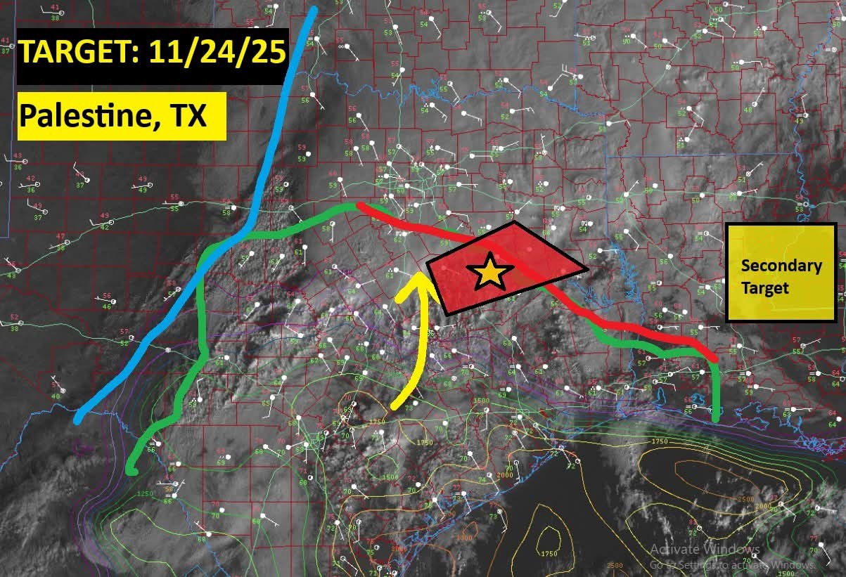 Live emergency update: Targeting a strong #tornado threat in East Texas. A cluster of supercells is forecast to develop east of Waco and move through the Texas Piney Woods north of Houston through afternoon! With a 40 knot low-level jet, a strong tornado or two will be possible! www.facebook.com/sha re/v/1Uk5Y9KJy4/ My chase target today will begin in the area I've circled in red. HRRR currently shows storms and a couple supercells developing by 1:00PM. These will pose the risk for damaging winds, large hail, and a couple tornadoes as they move off to the east!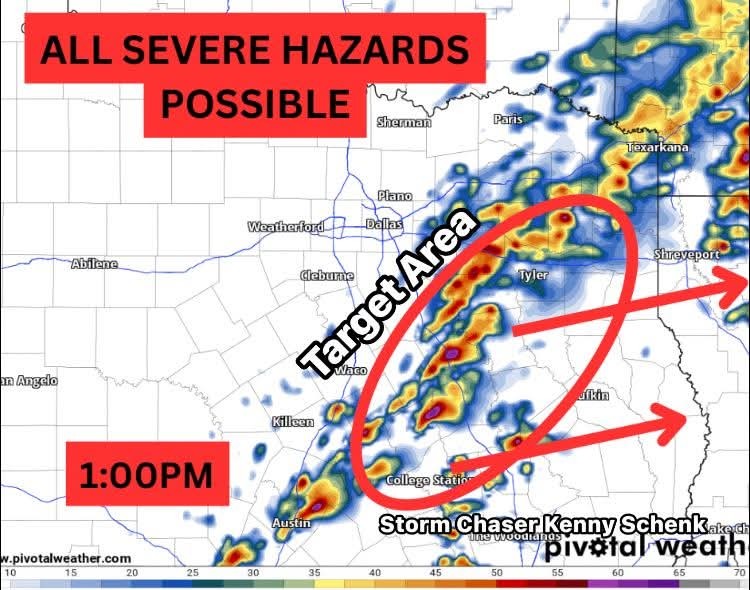
teatime, peppermintstick and cbear reacted ********
*******
Based on the chasers I follow, a lot of them seem to be positioning themselves south of the Tyler area or near Palestine. 👉 They all seem to agree that the most severe storms will be north of the Houston area. We could certainly see some strong storms though with gusty winds and hail. TODAY'S TORNADO TARGET: PALESTINE, TX This is where I will be targeting today. On the edge of slighty better terrain, and maximized CAPE values early in the day shortly after CI (convective initiation.) This is because I feel storms may be most discrete - at least during the day. Also, the surface flow will slowly veer out the entire day, so to me it just seems all the best ingredients line up early on - from the perspective of getting a daytime tornado. There's another area in southwest MS, near the LA border id be watching after dark as well, where the LLCJ and MLJ ramp up after dark near a surge of continuing moisture and instability. But thats the after dark play! ************ Live emergency update: Targeting a strong #tornado threat in East Texas. A cluster of supercells is forecast to develop east of Waco and move through the Texas Piney Woods north of Houston through afternoon! With a 40 knot low-level jet, a strong tornado or two will be possible! www.facebook.com/sha re/v/1Uk5Y9KJy4/ *********** My chase target today will begin in the area I've circled in red. HRRR currently shows storms and a couple supercells developing by 1:00PM. These will pose the risk for damaging winds, large hail, and a couple tornadoes as they move off to the east!
StormChaser : So.....does this appear to be a late afternoon event for us? I know....hard to know at this point. Best shot?
@StormChaser: Thanks for the update. Looking forward to cooler temperatures. Thankful for rain but hope none of the severe makes it here.
cbear, golfshot and Kittle + 1 more reacted StormChaser: Thanks for the update. Looking forward to cooler temperatures. Thankful for rain but hope none of the severe makes it here.
StormChaser : So.....does this appear to be a late afternoon event for us
cbear : 
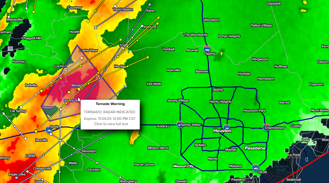
Tornado watch now in effect: 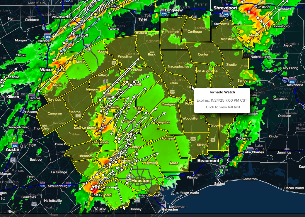 WWUS64 KLCH 241753
WCNLCH WATCH COUNTY NOTIFICATION FOR WATCH 638
NATIONAL WEATHER SERVICE LAKE CHARLES LA
1153 AM CST MON NOV 24 2025 TXC199-241-351-457-250100-
/O.NEW.KLCH.TO.A.0638.251124T1753Z-251125T0100Z/ THE NATIONAL WEATHER SERVICE HAS ISSUED TORNADO WATCH 638 IN
EFFECT UNTIL 7 PM CST THIS EVENING FOR THE FOLLOWING AREAS IN TEXAS THIS WATCH INCLUDES 4 COUNTIES IN SOUTHEAST TEXAS HARDIN JASPER NEWTON
TYLER THIS INCLUDES THE CITIES OF BLEAKWOOD, BUNA, BURKEVILLE, CALL,
FARRSVILLE, FRED, GIST, HILLISTER, HOLLY SPRINGS, IVANHOE,
JAMESTOWN, JASPER, KIRBYVILLE, LUMBERTON, MAGNOLIA SPRINGS,
MT. UNION, NEWTON, SILSBEE, SPURGER, TOWN BLUFF, WARREN,
WIERGATE, AND WOODVILLE.
WCNLCH
NATIONAL WEATHER SERVICE LAKE CHARLES LA
1153 AM CST MON NOV 24 2025
/O.NEW.KLCH.TO.A.0638.251124T1753Z-251125T0100Z/
EFFECT UNTIL 7 PM CST THIS EVENING FOR THE FOLLOWING AREAS
TYLER
FARRSVILLE, FRED, GIST, HILLISTER, HOLLY SPRINGS, IVANHOE,
JAMESTOWN, JASPER, KIRBYVILLE, LUMBERTON, MAGNOLIA SPRINGS,
MT. UNION, NEWTON, SILSBEE, SPURGER, TOWN BLUFF, WARREN,
WIERGATE, AND WOODVILLE.
« Back to Chat
Views: 361
# Replies: 11