


Weekend forecast
Weekend forecast


Joined:
X days ago
# Posts:
X,XXX
Contributor Points:
X


Weekend forecast -Near record temps this weekend and thru next week before a cold front arrives on Thursday.
-Severe weather possible with the passage of the front but it's too soon to forecast that. (Hopefully we see some MUCH needed rain)
-Severe drought coverage has expanded from 23 percent to 35 percent in the Houston area.
-The cold front drops temps back to average for November. (40s/60s)
-Turkey day still too early to forecast but cloudy & warm seem to be the trend. ................... From Space City Weather: Autumn eludes Houston over the next several days with near record warmth early next week. Matt Lanza
Friday, November 14, 2025 7:54 AM In brief: *Near record high temperatures will settle in over Houston, along with a burst of high humidity early next week.
*Our next front is penciled in for Thursday with a good chance of much needed thunderstorms showing up in the current forecast. *Bush Airport hit 83 degrees yesterday, 3 off the record of 86° set 20 years ago.
*Today's record of 89° looks pretty safe as well.
*Get used to these low to mid-80s because they're going to be with us over the next 5 or 6 days. TODAY THROUGH SUNDAY: *The next three days will be cut from the same cloth - Expect sun, some clouds (especially in the morning, along with perhaps some patchy fog), and warm, humid conditions.
*We'll probably do low to mid-80s today and tomorrow and more firm mid-80s on Sunday.
*An isolated sprinkle or two can't be entirely ruled out, as well as some drizzle in areas with morning fog. (I'm mainly mentioning that because we don't want to be told that we "mist" the forecast) 😁 NEXT WEEK - Monday and Tuesday: *We really dig in on the humidity here. That may be the only thing that prevents us from hitting the upper-90s.
*Gulf moisture starts to pool over the area, allowing dewpoints to push closer to 70° at times.
*Precipitable water - or the amount of available moisture in the atmosphere - goes from about 1 inch or so on Sunday, 1.5 inches on Monday, to 1.5 to 1.75 inches on Tuesday.
*Humid air heats up slower than dry air, so there's probably a functional limit to how warm we can realistically get Monday and Tuesday.
*Some model guidance is very bullish, pushing us close to 88 degrees, but I think we'll settle in the 84 to 86 degree range away from the coast most days, close enough to threaten or break records but not outlandishly hot for mid-November.
*An isolated shower is possible Monday with a slightly better chance for isolated showers on Tuesday. (Most folks will remain dry, but some will see a passing shower) 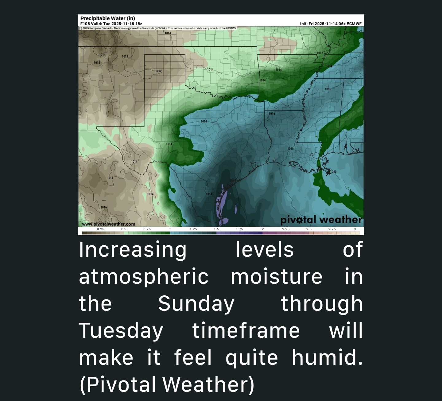 LATER NEXT WEEK: *Models are settling on Thursday as cold front day next week. While this looks like a quick moving system, it does look like it will be fairly moisture-laden, which is good because we need rain.
*Severe drought coverage expanded from 23 percent to 35 percent in the Houston area based on yesterday's drought monitor report.
*We continue to see extreme drought bubbling up west of Sealy and Wharton so any rain will be welcome. 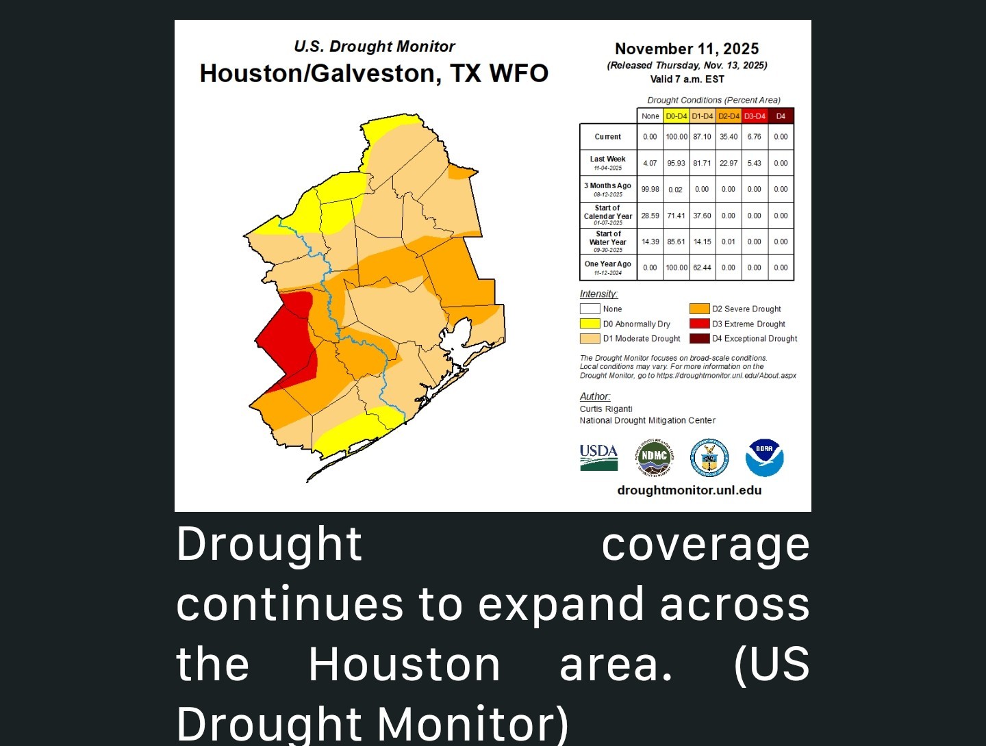 *Thursday's front looks interesting on some model guidance in that it may have some element of severe weather risk. It's too early to speculate much but the basic ingredients seem to be in place. Bottom line? Expect a cold front on Thursday that could perhaps be accompanied by some noisy thunderstorms and locally heavy rain. More to come on that. *Behind that front, much cooler weather arrives, though at this point it looks to fall short of what we saw earlier this week.
*Expect highs in the 60s and low 70s with lows in the 40s and 50s most likely.
*We will continue to fine tune things a bit. At least it will be closer to average for November. ...... FUNDRAISER: Our annual fundraiser continues, and we want to thank all that have purchased items or contributed to the site. Your support ensures that we can provide quality information year-round, in the good weather times, and in the inevitably bad weather times. For more information on how to donate or purchase merchandise, please visit our website. Thank you so much again for your support!


RolloTomaso, teatime and Kittle + 6 more reacted -Severe weather possible with the passage of the front but it's too soon to forecast that. (Hopefully we see some MUCH needed rain)
-Severe drought coverage has expanded from 23 percent to 35 percent in the Houston area.
-The cold front drops temps back to average for November. (40s/60s)
-Turkey day still too early to forecast but cloudy & warm seem to be the trend.
Friday, November 14, 2025 7:54 AM
*Our next front is penciled in for Thursday with a good chance of much needed thunderstorms showing up in the current forecast.
*Today's record of 89° looks pretty safe as well.
*Get used to these low to mid-80s because they're going to be with us over the next 5 or 6 days.
*We'll probably do low to mid-80s today and tomorrow and more firm mid-80s on Sunday.
*An isolated sprinkle or two can't be entirely ruled out, as well as some drizzle in areas with morning fog. (I'm mainly mentioning that because we don't want to be told that we "mist" the forecast) 😁
*Gulf moisture starts to pool over the area, allowing dewpoints to push closer to 70° at times.
*Precipitable water - or the amount of available moisture in the atmosphere - goes from about 1 inch or so on Sunday, 1.5 inches on Monday, to 1.5 to 1.75 inches on Tuesday.
*Humid air heats up slower than dry air, so there's probably a functional limit to how warm we can realistically get Monday and Tuesday.
*Some model guidance is very bullish, pushing us close to 88 degrees, but I think we'll settle in the 84 to 86 degree range away from the coast most days, close enough to threaten or break records but not outlandishly hot for mid-November.
*An isolated shower is possible Monday with a slightly better chance for isolated showers on Tuesday. (Most folks will remain dry, but some will see a passing shower)
*Severe drought coverage expanded from 23 percent to 35 percent in the Houston area based on yesterday's drought monitor report.
*We continue to see extreme drought bubbling up west of Sealy and Wharton so any rain will be welcome.
*Expect highs in the 60s and low 70s with lows in the 40s and 50s most likely.
*We will continue to fine tune things a bit. At least it will be closer to average for November.
Replies:
Weekend forecast -Near record temps this weekend and thru next week before a cold front arrives on Thursday. -Severe weather possible with the passage of the front but it's too soon to forecast that. (Hopefully we see some MUCH needed rain) -Severe drought coverage has expanded from 23 percent to 35 percent in the Houston area. -The cold front drops temps back to average for November. (40s/60s) -Turkey day still too early to forecast but cloudy & warm seem to be the trend. ................... From Space City Weather: Autumn eludes Houston over the next several days with near record warmth early next week. Matt Lanza Friday, November 14, 2025 7:54 AM In brief: *Near record high temperatures will settle in over Houston, along with a burst of high humidity early next week. *Our next front is penciled in for Thursday with a good chance of much needed thunderstorms showing up in the current forecast. *Bush Airport hit 83 degrees yesterday, 3 off the record of 86° set 20 years ago. *Today's record of 89° looks pretty safe as well. *Get used to these low to mid-80s because they're going to be with us over the next 5 or 6 days. TODAY THROUGH SUNDAY: *The next three days will be cut from the same cloth - Expect sun, some clouds (especially in the morning, along with perhaps some patchy fog), and warm, humid conditions. *We'll probably do low to mid-80s today and tomorrow and more firm mid-80s on Sunday. *An isolated sprinkle or two can't be entirely ruled out, as well as some drizzle in areas with morning fog. (I'm mainly mentioning that because we don't want to be told that we "mist" the forecast) 😁 NEXT WEEK - Monday and Tuesday: *We really dig in on the humidity here. That may be the only thing that prevents us from hitting the upper-90s. *Gulf moisture starts to pool over the area, allowing dewpoints to push closer to 70° at times. *Precipitable water - or the amount of available moisture in the atmosphere - goes from about 1 inch or so on Sunday, 1.5 inches on Monday, to 1.5 to 1.75 inches on Tuesday. *Humid air heats up slower than dry air, so there's probably a functional limit to how warm we can realistically get Monday and Tuesday. *Some model guidance is very bullish, pushing us close to 88 degrees, but I think we'll settle in the 84 to 86 degree range away from the coast most days, close enough to threaten or break records but not outlandishly hot for mid-November. *An isolated shower is possible Monday with a slightly better chance for isolated showers on Tuesday. (Most folks will remain dry, but some will see a passing shower) LATER NEXT WEEK: *Models are settling on Thursday as cold front day next week. While this looks like a quick moving system, it does look like it will be fairly moisture-laden, which is good because we need rain. *Severe drought coverage expanded from 23 percent to 35 percent in the Houston area based on yesterday's drought monitor report. *We continue to see extreme drought bubbling up west of Sealy and Wharton so any rain will be welcome. *Thursday's front looks interesting on some model guidance in that it may have some element of severe weather risk. It's too early to speculate much but the basic ingredients seem to be in place. Bottom line? Expect a cold front on Thursday that could perhaps be accompanied by some noisy thunderstorms and locally heavy rain. More to come on that. *Behind that front, much cooler weather arrives, though at this point it looks to fall short of what we saw earlier this week. *Expect highs in the 60s and low 70s with lows in the 40s and 50s most likely. *We will continue to fine tune things a bit. At least it will be closer to average for November. ...... FUNDRAISER: Our annual fundraiser continues, and we want to thank all that have purchased items or contributed to the site. Your support ensures that we can provide quality information year-round, in the good weather times, and in the inevitably bad weather times. For more information on how to donate or purchase merchandise,  lease visit our website. Thank you so much again for your support!
lease visit our website. Thank you so much again for your support!StormChaser : I am betting that Thanksgiving will be warmer than normal.
I was so hoping we had said goodbye to summer!
Weathergirl5 : Me too. So ready for cooler weather. We really do need rain also.
StormChaser : Thank you for keeping us informed. Have a great day and weekend.
peppermintstick : Yes, originally they said we were going to get some rain Sunday with the next Front, but last I heard they had backed off of that. Hopefully the forecast will change and we will get some rain on Sunday.
I was so hoping we had said goodbye to summer!
Weathergirl5 : Me too!!! I think Santa might be actually sweating this year!
Weathergirl5 : Me too. So ready for cooler weather. We really do need rain also.
peppermintstick : FOX 26 shows increasing chances of rain at ......the end of next week! I think the very best chance is 70% next Sunday.
cbear : Gosh I hope it's not hot for Thanksgiving and Christmas! I want seasonable weather.
cbear : Gosh I hope it's not hot for Thanksgiving and Christmas! I want seasonable weather.
Weathergirl5 : I do think we might have a warm Thanksgiving but...Christmas is too far away to get a feel for.
cbear : Gosh I hope it's not hot for Thanksgiving and Christmas! I want seasonable weather.
Weathergirl5 : I have been know to have the A/C on and the fire going on Christmas!!
cbear : Space City says Thursday so it would be nice to get some on both days.
peppermintstick : Today they are saying starting Tuesday...rain chances go up a bit. Fingers crossed. « Back to Chat
Views: 341
# Replies: 12