


Weekend forecast
Weekend forecast


Joined:
X days ago
# Posts:
X,XXX
Contributor Points:
X


Weekend forecast Rain chances are on the increase today and tomorrow before a front arrives on Sunday. Unfortunately, these won't be high rain totals, and not everyone will see rain, but at least it's a chance. FRIDAY and SATURDAY - *The onshore flow and rising atmospheric moisture levels will bring a decent chance of rain into the forecast on Friday and Saturday.
*Let's be clear: both days are likely to have partly to mostly sunny skies. But there will be the possibility of a passing shower, with overall chances of 40 to 50 percent daily.
*Accumulations for the most part will be on the order of a tenth of an inch, but I could see a few areas that see stronger showers that put down half an inch.
*This is all probably going to be very hit or miss.
*Temperatures will generally range from the mid-80s to about 90 degrees further inland, with plenty of humidity.
*Nights will be warm, in the lower 70s. 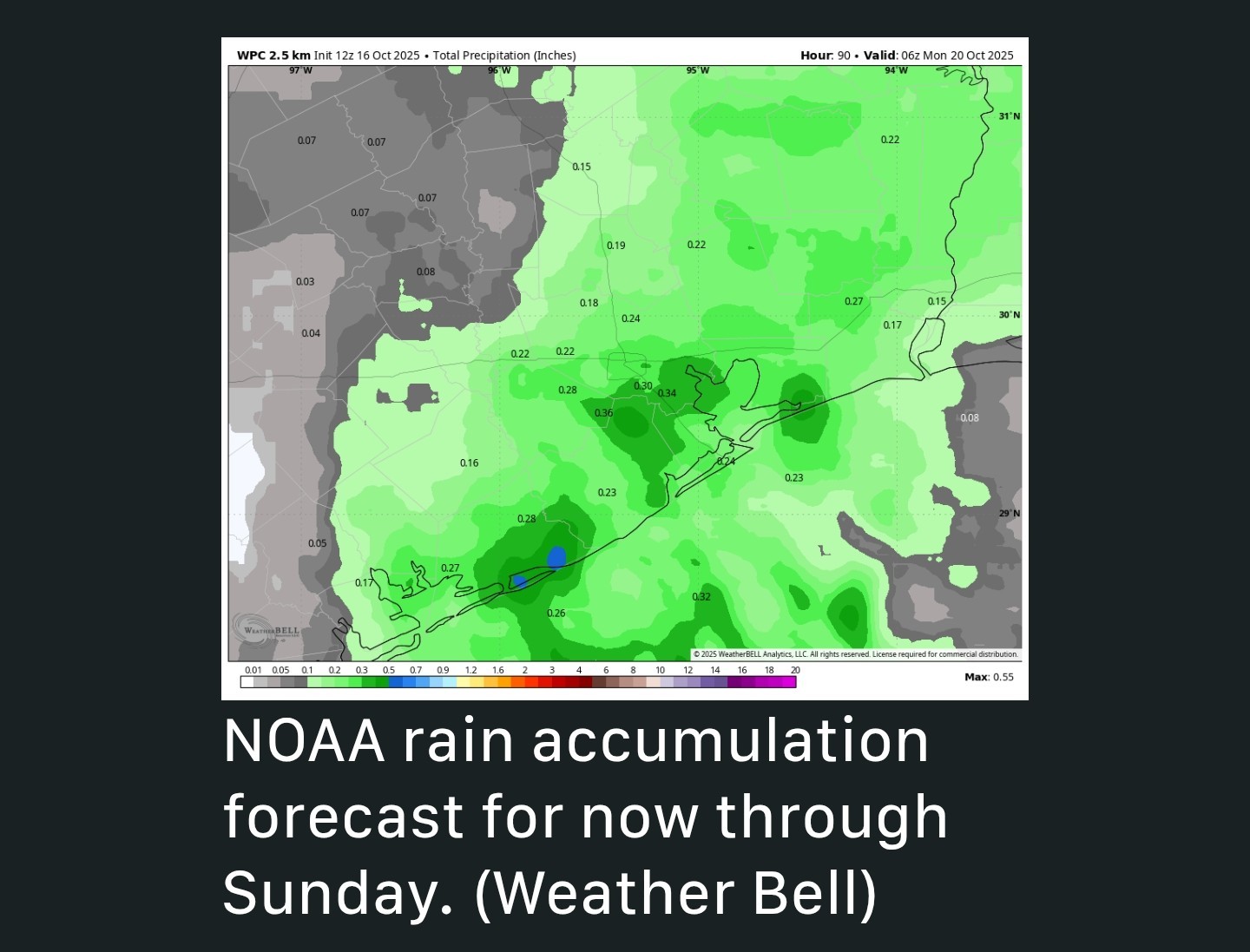 SUNDAY - *This is the day when a cool front will approach and (probably!) move through Houston and down to the coast.
*The European (and other) models remain fairly bullish on a nose of drier air dropping down into Houston on Sunday, but there is some uncertainty.
*Basically, I think if you live along and north of Interstate 10, you're going to see a good shot of less humid air for a day or so, and but the closer one lives to the coast, the lower the chances and the less dry air.
*In short, this is not going to be a strong front that barrels off the coast and leaves us all saying, "Ahhh."
*With that said, most of Houston will probably see highs in the upper 80s on Sunday with lower humidity and sunny skies.
*Temperatures on Sunday night will vary widely, with some inland areas probably dropping into the 50s, but the coast remaining stubbornly in the 70s. 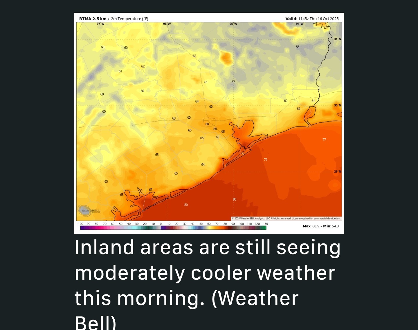 NEXT WEEK - *Who knows. I think the front on Sunday will wash out pretty quickly but then we might see another one on Tuesday or Tuesday night.
*And then maybe a stronger something or other by Thursday or so.
*The models are flopping around a lot. There also appear to be some rain chances sprinkled in.
*The upper-level pattern next week does support the sending of a front all the way through Houston later next week, so let's see what happens.
*I'll guarantee you this: If we get a strong cold front, we will comp everyone's admission to Fall Day. (That's a joke, just to be clear. Fall Day, like this website, is free and open to everyone).



AggieBandMom, CatalinaKitKat and peppermintstick + 2 more reacted *Let's be clear: both days are likely to have partly to mostly sunny skies. But there will be the possibility of a passing shower, with overall chances of 40 to 50 percent daily.
*Accumulations for the most part will be on the order of a tenth of an inch, but I could see a few areas that see stronger showers that put down half an inch.
*This is all probably going to be very hit or miss.
*Temperatures will generally range from the mid-80s to about 90 degrees further inland, with plenty of humidity.
*Nights will be warm, in the lower 70s.
*The European (and other) models remain fairly bullish on a nose of drier air dropping down into Houston on Sunday, but there is some uncertainty.
*Basically, I think if you live along and north of Interstate 10, you're going to see a good shot of less humid air for a day or so, and but the closer one lives to the coast, the lower the chances and the less dry air.
*In short, this is not going to be a strong front that barrels off the coast and leaves us all saying, "Ahhh."
*With that said, most of Houston will probably see highs in the upper 80s on Sunday with lower humidity and sunny skies.
*Temperatures on Sunday night will vary widely, with some inland areas probably dropping into the 50s, but the coast remaining stubbornly in the 70s.
*And then maybe a stronger something or other by Thursday or so.
*The models are flopping around a lot. There also appear to be some rain chances sprinkled in.
*The upper-level pattern next week does support the sending of a front all the way through Houston later next week, so let's see what happens.
*I'll guarantee you this: If we get a strong cold front, we will comp everyone's admission to Fall Day. (That's a joke, just to be clear. Fall Day, like this website, is free and open to everyone).
Replies:
Looking somewhat promising on future radar! But we have seen that before!
larpa and StormChaser reacted
Of course they updated the post right after I posted this lol. Scattered showers and some embedded thunderstorms will dot the Houston area today and Saturday, although we really, really need some rain. A generally pleasant stretch of weather will follow, with periodic cool fronts reinforcing warm but mostly comfortable autumn weather. Our first real big front of the season may be on the horizon before Halloween. Friday through Sunday Scattered showers are going to pop up today across the region. We need the rain. Drought now covers nearly 40 percent of the Houston area, with severe drought now showing up in parts of Colorado and Wharton Counties. If you get a passing shower today or tomorrow, consider yourself fortunate. Expect showers today to behave with the heating of the day, increasing in coverage from morning through afternoon, then diminishing after dark. Showers should maneuver farther inland today so hopefully other parts of the area away from the coast could pick up a scattered quarter to half-inch of rain. On Saturday, showers will start in the morning again, initially mostly near the coast and west of I-45 out across Katy into Fort Bend County. By the time we get to midday, the focus of the activity should migrate eastward toward I-45 and perhaps east of downtown Houston. Include an umbrella in your plans both Friday and Saturday anywhere in the area, but it is unlikely you'll need one all day or even most of the day. We probably won't see severe weather on Saturday, but to our north, there is a slight risk (level 2 of 5) in place up toward Lufkin and a marginal risk (level 1 of 5) closer to Lake Livingston. The front itself passes on Sunday morning around sunrise. Right now, we aren't expecting much fanfare with the front; it looks like a dry passage. We'll see temperatures and humidity drop off a bit as it does so. The rest of the day looks breezy with sunshine and highs in the upper 80s. It will feel much more comfortable. Some wildfire risk is in place in the area Sunday afternoon, but it does not appear any worse than previous wildfire risk days we've had so far this autumn. Just use caution with anything flammable outdoors. Early next week
Monday looks sunny and pleasant with highs in the upper-80s and morning lows in the 50s and 60s. Another front should reinforce this pleasant but not quite "cool" air mass on Tuesday night. It may bring a few showers out ahead of it as humidity attempts to return, but the odds look minimal right now. We'll hold with mid to upper 80s for highs and generally 60s for lows. Later next week
I'm with Eric that we could very well see another weak cold front later in the week. It does not appear to be THE fall front just yet, however. There is increasing signal in the modeling that that front will wait until right before Halloween. We'll either be celebrating the arrival of fall or celebrating its imminent arrival at our Fall Day celebration next weekend. Stay tuned.
CatalinaKitKat, peppermintstick and SteveT reacted Monday looks sunny and pleasant with highs in the upper-80s and morning lows in the 50s and 60s. Another front should reinforce this pleasant but not quite "cool" air mass on Tuesday night. It may bring a few showers out ahead of it as humidity attempts to return, but the odds look minimal right now. We'll hold with mid to upper 80s for highs and generally 60s for lows.
I'm with Eric that we could very well see another weak cold front later in the week. It does not appear to be THE fall front just yet, however. There is increasing signal in the modeling that that front will wait until right before Halloween. We'll either be celebrating the arrival of fall or celebrating its imminent arrival at our Fall Day celebration next weekend. Stay tuned.
Of course they updated the post right after I posted this lol. Scattered showers and some embedded thunderstorms will dot the Houston area today and Saturday, although we really, really need some rain. A generally pleasant stretch of weather will follow, with periodic cool fronts reinforcing warm but mostly comfortable autumn weather. Our first real big front of the season may be on the horizon before Halloween. Friday through Sunday Scattered showers are going to pop up today across the region. We need the rain. Drought now covers nearly 40 percent of the Houston area, with severe drought now showing up in parts of Colorado and Wharton Counties. If you get a passing shower today or tomorrow, consider yourself fortunate. Expect showers today to behave with the heating of the day, increasing in coverage from morning through afternoon, then diminishing after dark. Showers should maneuver farther inland today so hopefully other parts of the area away from the coast could pick up a scattered quarter to half-inch of rain. On Saturday, showers will start in the morning again, initially mostly near the coast and west of I-45 out across Katy into Fort Bend County. By the time we get to midday, the focus of the activity should migrate eastward toward I-45 and perhaps east of downtown Houston. Include an umbrella in your plans both Friday and Saturday anywhere in the area, but it is unlikely you'll need one all day or even most of the day. We probably won't see severe weather on Saturday, but to our north, there is a slight risk (level 2 of 5) in place up toward Lufkin and a marginal risk (level 1 of 5) closer to Lake Livingston. The front itself passes on Sunday morning around sunrise. Right now, we aren't expecting much fanfare with the front; it looks like a dry passage. We'll see temperatures and humidity drop off a bit as it does so. The rest of the day looks breezy with sunshine and highs in the upper 80s. It will feel much more comfortable. Some wildfire risk is in place in the area Sunday afternoon, but it does not appear any worse than previous wildfire risk days we've had so far this autumn. Just use caution with anything flammable outdoors. Early next week
Monday looks sunny and pleasant with highs in the upper-80s and morning lows in the 50s and 60s. Another front should reinforce this pleasant but not quite "cool" air mass on Tuesday night. It may bring a few showers out ahead of it as humidity attempts to return, but the odds look minimal right now. We'll hold with mid to upper 80s for highs and generally 60s for lows. Later next week
I'm with Eric that we could very well see another weak cold front later in the week. It does not appear to be THE fall front just yet, however. There is increasing signal in the modeling that that front will wait until right before Halloween. We'll either be celebrating the arrival of fall or celebrating its imminent arrival at our Fall Day celebration next weekend. Stay tuned.
Monday looks sunny and pleasant with highs in the upper-80s and morning lows in the 50s and 60s. Another front should reinforce this pleasant but not quite "cool" air mass on Tuesday night. It may bring a few showers out ahead of it as humidity attempts to return, but the odds look minimal right now. We'll hold with mid to upper 80s for highs and generally 60s for lows.
I'm with Eric that we could very well see another weak cold front later in the week. It does not appear to be THE fall front just yet, however. There is increasing signal in the modeling that that front will wait until right before Halloween. We'll either be celebrating the arrival of fall or celebrating its imminent arrival at our Fall Day celebration next weekend. Stay tuned.
 larpa tipped StormChaser 100 credits for a post in this forum discussion.
 StormChaser: Praying we all get some much needed rain. Looking forward to cooler and less humid.
Of course they updated the post right after I posted this lol. Scattered showers and some embedded thunderstorms will dot the Houston area today and Saturday, although we really, really need some rain. A generally pleasant stretch of weather will follow, with periodic cool fronts reinforcing warm but mostly comfortable autumn weather. Our first real big front of the season may be on the horizon before Halloween. Friday through Sunday Scattered showers are going to pop up today across the region. We need the rain. Drought now covers nearly 40 percent of the Houston area, with severe drought now showing up in parts of Colorado and Wharton Counties. If you get a passing shower today or tomorrow, consider yourself fortunate. Expect showers today to behave with the heating of the day, increasing in coverage from morning through afternoon, then diminishing after dark. Showers should maneuver farther inland today so hopefully other parts of the area away from the coast could pick up a scattered quarter to half-inch of rain. On Saturday, showers will start in the morning again, initially mostly near the coast and west of I-45 out across Katy into Fort Bend County. By the time we get to midday, the focus of the activity should migrate eastward toward I-45 and perhaps east of downtown Houston. Include an umbrella in your plans both Friday and Saturday anywhere in the area, but it is unlikely you'll need one all day or even most of the day. We probably won't see severe weather on Saturday, but to our north, there is a slight risk (level 2 of 5) in place up toward Lufkin and a marginal risk (level 1 of 5) closer to Lake Livingston. The front itself passes on Sunday morning around sunrise. Right now, we aren't expecting much fanfare with the front; it looks like a dry passage. We'll see temperatures and humidity drop off a bit as it does so. The rest of the day looks breezy with sunshine and highs in the upper 80s. It will feel much more comfortable. Some wildfire risk is in place in the area Sunday afternoon, but it does not appear any worse than previous wildfire risk days we've had so far this autumn. Just use caution with anything flammable outdoors. Early next week
Monday looks sunny and pleasant with highs in the upper-80s and morning lows in the 50s and 60s. Another front should reinforce this pleasant but not quite "cool" air mass on Tuesday night. It may bring a few showers out ahead of it as humidity attempts to return, but the odds look minimal right now. We'll hold with mid to upper 80s for highs and generally 60s for lows. Later next week
I'm with Eric that we could very well see another weak cold front later in the week. It does not appear to be THE fall front just yet, however. There is increasing signal in the modeling that that front will wait until right before Halloween. We'll either be celebrating the arrival of fall or celebrating its imminent arrival at our Fall Day celebration next weekend. Stay tuned.
Monday looks sunny and pleasant with highs in the upper-80s and morning lows in the 50s and 60s. Another front should reinforce this pleasant but not quite "cool" air mass on Tuesday night. It may bring a few showers out ahead of it as humidity attempts to return, but the odds look minimal right now. We'll hold with mid to upper 80s for highs and generally 60s for lows.
I'm with Eric that we could very well see another weak cold front later in the week. It does not appear to be THE fall front just yet, however. There is increasing signal in the modeling that that front will wait until right before Halloween. We'll either be celebrating the arrival of fall or celebrating its imminent arrival at our Fall Day celebration next weekend. Stay tuned.
@CatalinaKitKat tipped
StormChaser 100 credits for a post in this forum discussion. 
« Back to Chat
Views: 262
# Replies: 10