


Weekend forecast - winter weather update
Weekend forecast - winter weather update


Joined:
X days ago
# Posts:
X,XXX
Contributor Points:
X
Replies:


 StormChaser :
Heck now it looks like the ice will be short lived which is good but sad for my work day Monday haha
Weekend forecast - winter weather update Lots of info - *The biggest change is that we'll see thunderstorm tomorrow morning with up to 1.5" of rain possible. Temps will be well above freezing at the time, but the roads will be very wet afterwards & the temps will drop into the 20s late Saturday evening. Elevated surfaces will likely have big issues overnight Saturday and all day Sunday. *Sunday still had lots of what ifs but I think we could see a little of everything; even a bit of snow. (NO accumulation likely) *Monday morning will all be determined by if we get above freezing on Sunday. It's going to be close so we'll see. I wouldn't be surprised if there were issues on the roadways Monday AM. *We have ANOTHER Arctic front coming next weekend and the models show an increased snow chance in SE Texas, but it's way too early to forecast. We'll see. ❄️ ......... From Space City Weather: The Arctic front is now nearing Texas. Here's the latest on what it means for the greater Houston area. Eric Berger · Friday, January 23, 2026 6:57 AM In brief: *In today's post we dive into the latest data about the impending winter storm and share our thoughts about freezing rain, hard freezes, and more in Houston. *There is also a new wrinkle, with the potential for thunderstorms on Saturday morning. Because, why not? 🤦♀️ Winter Storm overview - *We continue to monitor the impacts from an Arctic front that will arrive this weekend in the Houston region. *Friday and Saturday should be fine for getting around, although in a new wrinkle we now anticipate the potential for some thunderstorms on Saturday morning. *Fortunately, this will fall just as rain. *We are still watching closely for when temperatures reach the freezing mark in the metro area, as that will make all the difference as to whether we see freezing rain and icy roads on Sunday morning. See below for a full discussion of all this. FRIDAY - *We are seeing plenty of fog across the area this morning, with light winds, and temperatures and dewpoints both settling at about 60 degrees. *Highs today will push into the upper 60s, with mostly cloudy skies. *We could see a few light showers, but these should be nothing to write home about. *Lows tonight should drop into the 50s, area-wide, as the initial push of colder air arrives from the cold front. Radar pic SATURDAY - *There's a new threat to talk about on Saturday. *There will be an interesting setup with very moist, and warm air offshore and much colder air over inland parts of Texas. This could well lead to the development of some thunderstorms during the mid-morning hours on Saturday, as essentially a line of storms pushes through. *This is likely to drop 0.5 to 1.0 inch of rain pretty quickly, and I hope the city's efforts to treat bridges and overpasses for ice (which may come later) takes this rainfall into account. *With temperatures likely around 50 degrees in Houston on Saturday, this will indeed just fall as rain. *After these showers and storms move through, we could see an end to precipitation for awhile on Saturday afternoon, although our skies will remain mostly cloudy. *Temperatures likely will hover in the 40s during the afternoon hours, with modest northerly winds. At some point on Saturday evening, to Saturday night, freezing temperatures will start to get closer to the area. *They could arrive in Montgomery County by around 9 pm to midnight, and likely not moving into Harris and counties closer to the coast until after midnight or later. *I expect area roadways to remain passable, at the very least, through Saturday evening. SUNDAY - Ahh, Sunday. This day remains the bane of a forecaster's existence. We really need to know precise temperatures throughout the day, literally to within a degree, and as of yet we still don't have that kind of certainty. *With that said, I expect to see additional light showers overnight on Saturday into Sunday, followed by what may be a second line of showers and thunderstorms around sunrise on Sunday, or shortly thereafter. *Then, the rain should exit to our east, for good. MONDAY - *What roads look like on Monday morning will depend on what they looked like Sunday evening. *We are not going to see any additional precipitation, so if they're dry on Sunday night, they'll be dry on Monday morning. *We should see temperatures climb to highs between 35 and 40 degrees on Monday, and with clear skies and light winds, we can expect another very cold night. *Temperatures likely only be 1 to 3 degrees above conditions on Sunday night. ➡️Question no. 1 is: How cold will temperatures be across the metro area at sunrise on Sunday? If they're below freezing at your location, there's a decent chance of some minor ice accumulation. If they're above freezing at your location, it's just very cold rain. I think there's about a 50 percent chance of freezing temperatures in a location such as The Woodlands at this time, and perhaps less than 50 percent along the I-10 corridor in Houston, and less still south of there. So when you wake up on Sunday, and consider going out and about, you're going to need to be weather aware. Check local temperatures. See if the precipitation has moved on. Read what we're saying here. Roads on Sunday morning may be fine. They may be mostly OK with some issues on elevated surfaces. Or it may be pretty icy out there and you should stay inside. For now our best guess (emphasis on guess) is this: 🧊There could be up to 0.2 inch of ice accumulation in Montgomery County, especially along and north of Highway 105. 🧊Areas of northwest Harris County, as well as Waller and Austin counties, may see some minor ice accumulations. *Areas closer to the coast probably will not. Pick and white Pic ➡️ Question no. 2 is: How warm will temperatures get on Sunday afternoon? As precipitation exits to the east, we should see some partially clearing skies on Sunday. With gusty northwesterly winds (perhaps up to 25 mph from the north) we are going to see a lot of very cold air advecting in. If temperatures are above freezing in your location for a couple of hours, with a little sunshine and these winds, we are going to see good conditions to dry out roads. However, if temperatures remain at or below freezing at your location, any ice is going to stick around. My general guess is that we are going to see roads dry out, at least in non-shadowed areas. But an alternative possibility is that we don't get enough heat or sunlight before frigid temperatures descend Sunday evening. Again this is going to have to be a game time decision. We remain highly confident in temperatures plunging on Sunday night, probably down to the 20-25 degree range in urban Houston, with conditions a little warmer closer to the coast, and a little cooler in places like Katy and The Woodlands (15 to 25 degrees). Note there still is some uncertainty about how cold it will get. Continued below ⬇️
StormChaser : Thank you once again for your post!

|
Winter Storm Warning WINTER STORM WARNING IN EFFECT FROM 6 PM SATURDAY TO 6 PM CST SUNDAY: * WHAT...Heavy mixed precipitation expected. Total ice accumulations up to two tenths of an inch. * WHERE...Harris, Liberty, Waller, Fort Bend, Austin, Colorado, and Wharton Counties. * WHEN...From 6 PM Saturday to 6 PM CST Sunday. * IMPACTS...Travel could be nearly impossible, especially on bridges and overpasses. Power outages and tree damage are possible due to the ice. PRECAUTIONARY/PREPAREDNESS ACTIONS... If you must travel, keep an extra flashlight, food, and water in your vehicle in case of an emergency. The latest road conditions for the state you are calling from can be obtained by calling 5 1 1. ........ Extreme Cold Watch EXTREME COLD WARNING IN EFFECT FROM 6 PM SATURDAY TO NOON CST MONDAY... * WHAT...For the Extreme Cold Warning, dangerously cold wind chills as low as 5 below zero well inland to around 10 degrees along the coast expected. For the Extreme Cold Watch, dangerously cold wind chills as low as 5 to 15 degrees possible. * WHERE...Portions of south central and southeast Texas. * WHEN...For the Extreme Cold Warning, from 6 PM Saturday to noon CST Monday. For the Extreme Cold Watch, from Monday afternoon through Tuesday morning. * IMPACTS...Frostbite and hypothermia will occur if unprotected skin is exposed to these temperatures. Hard freeze conditions with an extended period of freezing temperatures could cause ruptured water pipes. PRECAUTIONARY/PREPAREDNESS ACTIONS... Dress in layers including a hat, face mask, and gloves if you must go outside. To prevent water pipes from freezing, wrap or drain them. Keep pets indoors as much as possible. Make sure outdoor animals have a warm, dry shelter, food, and unfrozen water. Make frequent checks on older family, friends, and neighbors. Ensure portable heaters are used correctly. Do not use generators or grills inside. Monitor the latest forecasts and warnings for updates. .......
Wingsofwonder, teatime and Kittle + 1 more reacted
|
|
NEW - Midday Friday - *Winter Storm Warnings* added for Houston & southeast Texas. *Ice Storm Warnings* issued for east Texas. 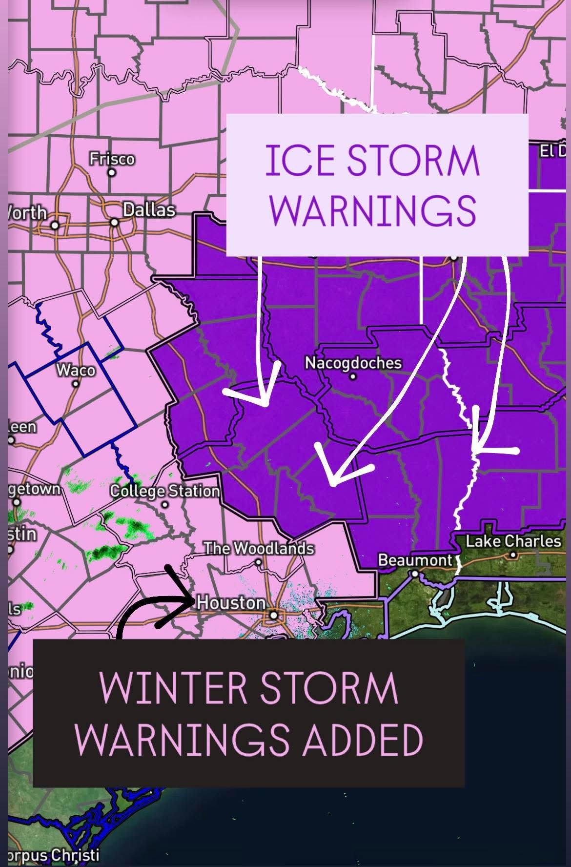
Wingsofwonder, teatime and Kittle reacted
|
|
3pm update: Here's what we know, and what we don't about the impending deep freeze. Eric Berger · Friday, January 23, 2026 2:11 PM In brief: *In today's post we discuss the ongoing forecast with a winter storm that is due to arrive in Houston about 36 hours from now.
*With this update we list some things we know, and some we don't about the forthcoming freeze. Overview - *We are about a day and a half from freezing temperatures descending into the Houston metro area.
*Not much has changed with our overall forecast.
*Area roadways should be fine through Saturday evening, but by early Sunday we have questions and concerns.
*At this point I'm a little more bullish in ice in the Houston metro area, so I am leaning a little more toward a disruptive event on Sunday and possibly Monday morning, especially for locations north of Interstate 10. But it is far from a done deal. We also still have questions about how cold temperatures will get on Monday and Tuesday mornings. I would ballpark lows at about 20 degrees in urban Houston (a little cooler for inland sites such as Katy, Tomball, The Woodlands, and Kingwood) and a little warmer for locations closer to the coast, such as League City. But there is the possibility those temperatures are too low. Anyway, on to what we know, and what we don't. We know: If you need to make a closure decision now, err on the side of caution. I'm still not sure what Houston's roads will look like on Sunday morning, later in the day, and on Monday morning. Following precipitation on Sunday morning, which could fall as freezing rain or cold rain, we could be anywhere from "bone dry" to "icy bridges and overpasses" to "widespread ice" by Sunday afternoon. I know this is a huge cop-out, but it's the truth due to uncertainty about air temperatures on Sunday. Anyway, we've already seen decisions by the Houston Independent School District and a handful of other districts to close on Monday. This is understandable, given the uncertainty. If you can't wait to make a closure decision, that's prudent. If you can wait, there's still a chance things will be mostly fine on roads. We don't know: What will happen with electricity? There are two issues with getting electricity into your home. The first of these is generation. This was the killer during the February 2021 winter storm, when large chunks of the Texas power grid were taken offline due to plants shutting down. If you're like me, you've been periodically checking the "supply and demand" projection from ERCOT. Everything looks more of less fine, but there does appear to be a potential supply crunch on Monday morning, around sunrise, when temperatures are at their coldest. The other issue is distribution, with the main concern in ice accumulating on tree limbs and power lines, causing them to snap. CenterPoint Energy, which is responsible for distribution in the greater Houston area, says they are making all necessary preparations. The bottom line is that I don't expect to see the extreme and disastrous power losses experienced during the winter storm of 2021. But that's not to say there won't be some disruptions in service. We know: People are panic shopping. I've heard from people, and can see from social media, that y'all are raiding grocery stores for all manner of supplies. (Pro tip: Kroger appears to be less crowded than HEB). But you don't need to stock up forever, friends. Regardless of what happens, roads will very likely be passable on Monday afternoon, and at the very worst Tuesday when we're back up into the 40s. We don't know: How low will temperatures go?
Forecasting low temperatures is difficult during winter events like this. One factor is ice. If there is a lot of it covering areas north of Houston, and within the city itself, than northerly winds moving over this ice will cool down more efficiently. This will lead to colder temperatures (possibly teens) in and around Houston. However it is also plausible that much of the city only drops to about 25 degrees. Our best advice is to prepare for the colder temperatures, and hope for "warmer" conditions. We know: Thunderstorms are possible on Saturday
A decent line of thunderstorms will pass through Houston on Saturday morning, likely during the mid-morning hours. Thunderstorms will be more likely along and south of Interstate 10 and closer to the coast. These could drop 1 to 2 inches of rain pretty quickly, so keep that in mind as part of your winterization preparations. After these storms pass I expect a lull in rain (for the most part) as temperatures drop into the 40s on Saturday afternoon. A second round of showers will likely spin up early on Sunday and persist into the mid-morning hours. We don't know: How airports will be affected
I know, you have flight questions. I wish we had answers. Flying on Saturday should not be problematic, but it's difficult to say the same about Sunday and possibly Monday morning. Of note, many airlines have issued waivers for change fees for today through Monday. We know: Space City Weather does not use made up storm names
The Weather Channel, as it has done for more than a decade, has named the impending winter storm "Fern." These names are not official, and there is no significant evidence they do anything to enhance safety. Also, "Fern" is a pretty dumb name for a storm. So we won't be using it (just like we have never used "Uri" for the 2021 deep freeze). Our next update will be posted by 7 am CT on Saturday. I will also be doing an additional Q&A at 11 am tomorrow. Thanks for your patience as we work through a difficult forecast here.
Wingsofwonder, teatime and Kittle reacted *With this update we list some things we know, and some we don't about the forthcoming freeze.
*Not much has changed with our overall forecast.
*Area roadways should be fine through Saturday evening, but by early Sunday we have questions and concerns.
*At this point I'm a little more bullish in ice in the Houston metro area, so I am leaning a little more toward a disruptive event on Sunday and possibly Monday morning, especially for locations north of Interstate 10.
Forecasting low temperatures is difficult during winter events like this. One factor is ice. If there is a lot of it covering areas north of Houston, and within the city itself, than northerly winds moving over this ice will cool down more efficiently. This will lead to colder temperatures (possibly teens) in and around Houston. However it is also plausible that much of the city only drops to about 25 degrees. Our best advice is to prepare for the colder temperatures, and hope for "warmer" conditions.
A decent line of thunderstorms will pass through Houston on Saturday morning, likely during the mid-morning hours. Thunderstorms will be more likely along and south of Interstate 10 and closer to the coast. These could drop 1 to 2 inches of rain pretty quickly, so keep that in mind as part of your winterization preparations. After these storms pass I expect a lull in rain (for the most part) as temperatures drop into the 40s on Saturday afternoon. A second round of showers will likely spin up early on Sunday and persist into the mid-morning hours.
I know, you have flight questions. I wish we had answers. Flying on Saturday should not be problematic, but it's difficult to say the same about Sunday and possibly Monday morning. Of note, many airlines have issued waivers for change fees for today through Monday.
The Weather Channel, as it has done for more than a decade, has named the impending winter storm "Fern." These names are not official, and there is no significant evidence they do anything to enhance safety. Also, "Fern" is a pretty dumb name for a storm. So we won't be using it (just like we have never used "Uri" for the 2021 deep freeze).
|
|
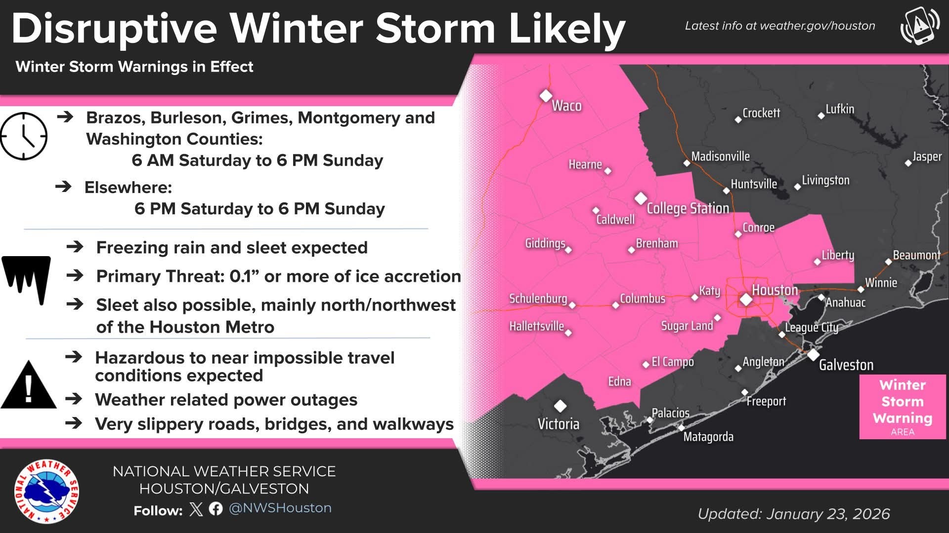
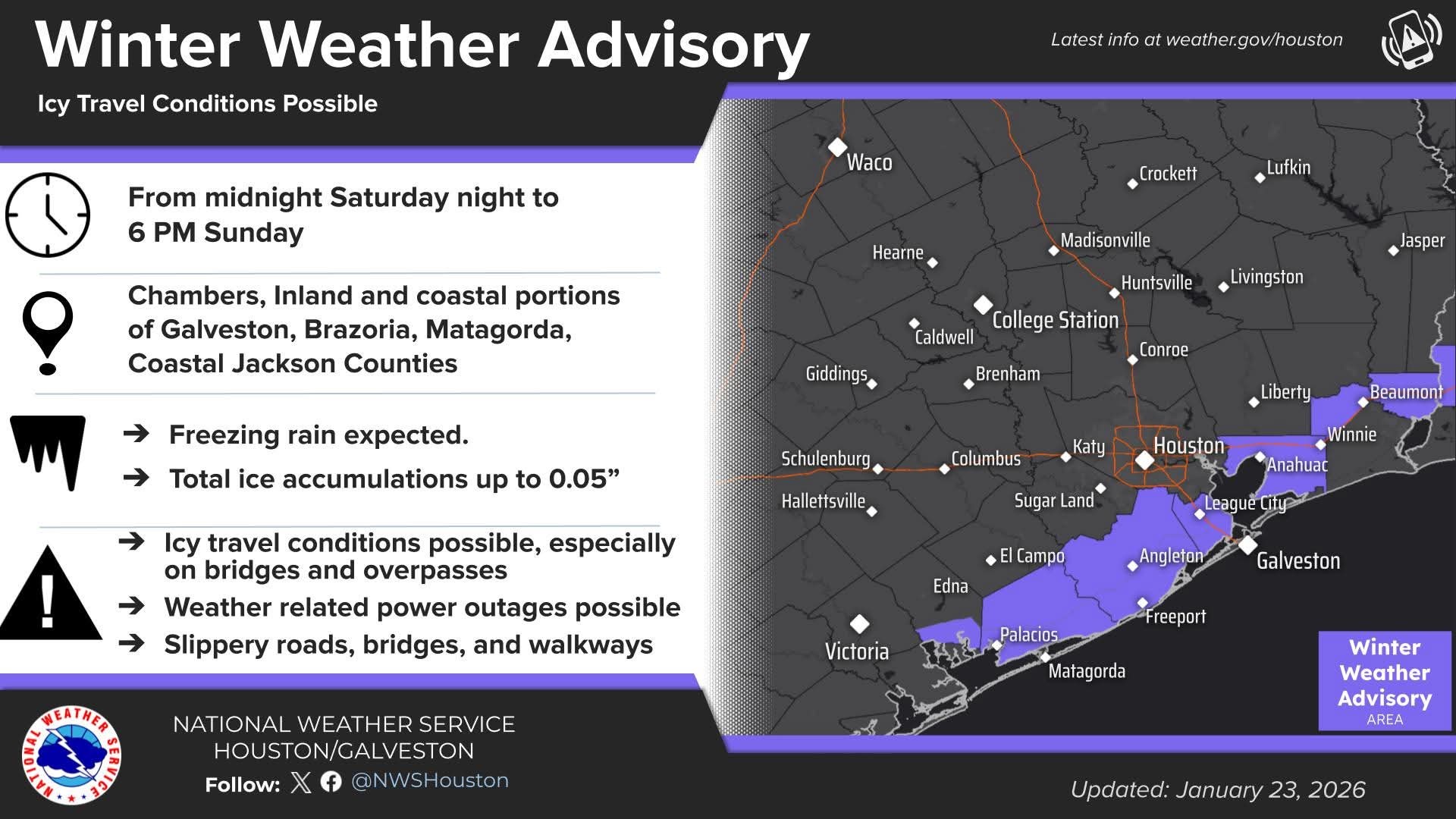
Ice Storm & Winter Storm Warnings are in effect for ice and sleet. Expect hazardous to near impossible travel and power outages. Dangerous Cold: An Extreme Cold Warning takes effect Saturday evening through early next week. Preparations should be completed today. 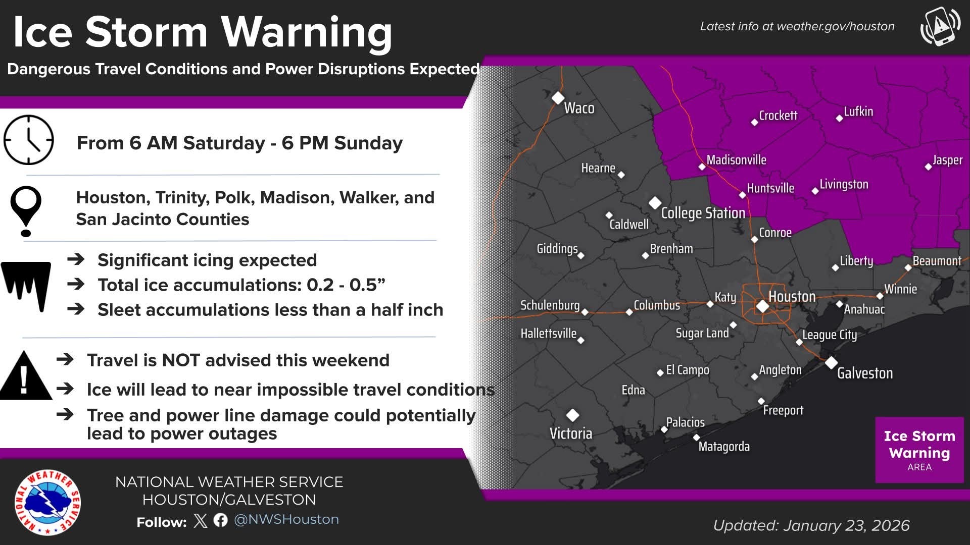
Wingsofwonder and Kittle reacted
|
|
1-23-26 320pm Winter Storm Warning in effect from 600pm Saturday to 600pm Sunday for ice accumulations of .05-.20 of an inch: Harris, Chambers Fort Bend, Wharton, Jackson, Montgomery, Waller, Austin, Liberty, Colorado, Washington, Grimes, and Brazos Counties.
Ice Storm Warning in effect from 600am Saturday to 600pm Sunday for ice accumulations of .25-.50 of an inch: San Jacinto, Polk, Walker, Trinity, Madison, and Houston Counties.
Winter Weather Advisory in effect from midnight to 600pm Sunday for ice accumulations of up to .05 of an inch: Galveston, Brazoria, Matagorda.
Extreme Cold Warning in effect from 600pm Saturday to noon Monday for wind chills of -5 to 15 degrees: all counties.
Dangerous and potentially damaging cold will be in place especially Monday and Tuesday mornings…maximum winterization preparations MUST be taken to mitigate infrastructure damage. 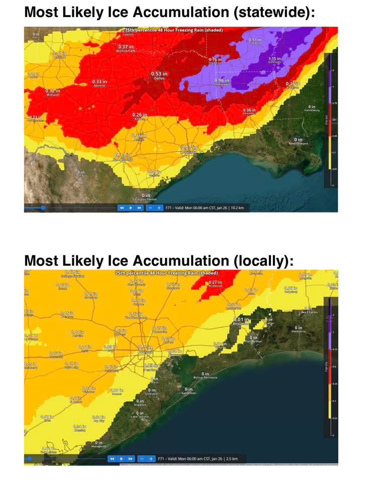
There have been no significant changes with the forecast temperatures nor the expected precipitation thus far today. We have added a period from 8:00am Saturday to midday for the potential for strong thunderstorms and heavy rainfall of 1-2 inches on Saturday. Freezing line will then move southward into Saturday evening and overnight with transition to freezing rain…heaviest and most widespread will come with the strong forcing associated with the upper level trough Sunday morning. Still some uncertainty on exactly when the freezing line reaches certain areas, but high resolution guidance has been a little on the faster side…but not enough to change anything at this point…will watch to see if this is sped up over the next few guidance cycles.
It should be noted that an extremely damaging ice storm is going to impact a large portion of TX north of our region with likely widespread power outages followed by brutally cold temperatures in the 10's and 1's for a very large area. This is going to greatly stress critical infrastructure in many areas of the state. 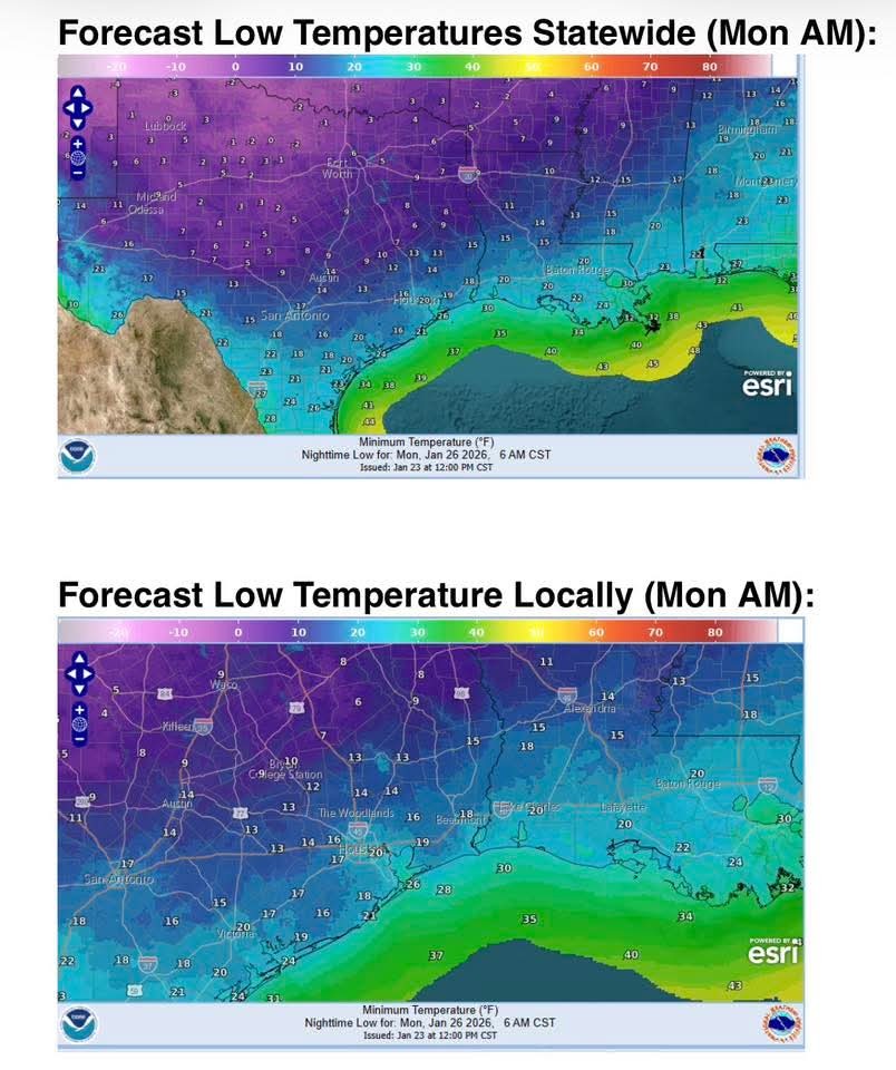
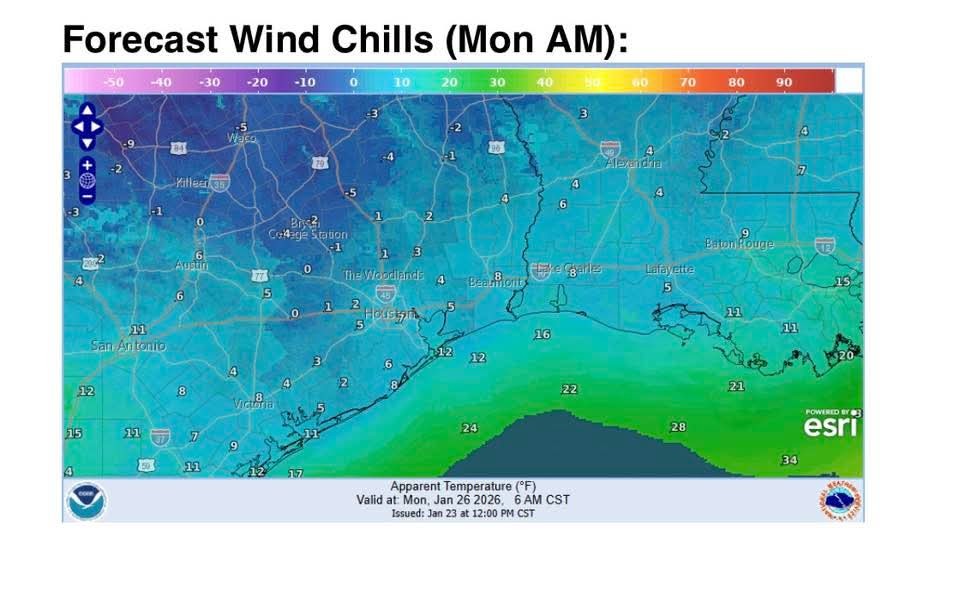
Cold and wind chills Monday and Tuesday mornings will be dangerous…do not underestimate this cold.
Proper winterization of any exposed pipes/plumbing MUST occur to prevent infrastructure damage. Sprinkler systems must be shut off and properly drained. Exterior facing wall pipes will be a risk of freezing at the forecasted temperatures.
Pets/livestock will require proper shelter to protect from the cold temperatures and wind chills. Unprotected pets and livestock risk hypothermia and death. Additionally, water sources are likely to freeze over.
Tropical plants/vegetation will require maximum freeze protection. Unprotected tropical vegetation will be killed and even protect vegetation will likely suffer extensive damage.
Persons should limit outdoor exposure during the cold. Utilize heating sources properly to reduce the risk of fire and carbon monoxide poisoning.
Wingsofwonder, Kittle and Mimilane + 1 more reacted Ice Storm Warning in effect from 600am Saturday to 600pm Sunday for ice accumulations of .25-.50 of an inch: San Jacinto, Polk, Walker, Trinity, Madison, and Houston Counties.
Winter Weather Advisory in effect from midnight to 600pm Sunday for ice accumulations of up to .05 of an inch: Galveston, Brazoria, Matagorda.
Extreme Cold Warning in effect from 600pm Saturday to noon Monday for wind chills of -5 to 15 degrees: all counties.
Dangerous and potentially damaging cold will be in place especially Monday and Tuesday mornings…maximum winterization preparations MUST be taken to mitigate infrastructure damage.
There have been no significant changes with the forecast temperatures nor the expected precipitation thus far today.
It should be noted that an extremely damaging ice storm is going to impact a large portion of TX north of our region with likely widespread power outages followed by brutally cold temperatures in the 10's and 1's for a very large area.
Cold and wind chills Monday and Tuesday mornings will be dangerous…do not underestimate this cold.
Proper winterization of any exposed pipes/plumbing MUST occur to prevent infrastructure damage. Sprinkler systems must be shut off and properly drained.
Pets/livestock will require proper shelter to protect from the cold temperatures and wind chills.
Tropical plants/vegetation will require maximum freeze protection.
Persons should limit outdoor exposure during the cold. Utilize heating sources properly to reduce the risk of fire and carbon monoxide poisoning.
|
|

1-23-26 320pm Winter Storm Warning in effect from 600pm Saturday to 600pm Sunday for ice accumulations of .05-.20 of an inch: Harris, Chambers Fort Bend, Wharton, Jackson, Montgomery, Waller, Austin, Liberty, Colorado, Washington, Grimes, and Brazos Counties. Ice Storm Warning in effect from 600am Saturday to 600pm Sunday for ice accumulations of .25-.50 of an inch: San Jacinto, Polk, Walker, Trinity, Madison, and Houston Counties. Winter Weather Advisory in effect from midnight to 600pm Sunday for ice accumulations of up to .05 of an inch: Galveston, Brazoria, Matagorda. Extreme Cold Warning in effect from 600pm Saturday to noon Monday for wind chills of -5 to 15 degrees: all counties. Dangerous and potentially damaging cold will be in place especially Monday and Tuesday mornings…maximum winterization preparations MUST be taken to mitigate infrastructure damage. There have been no significant changes with the forecast temperatures nor the expected precipitation thus far today. We have added a period from 8:00am Saturday to midday for the potential for strong thunderstorms and heavy rainfall of 1-2 inches on Saturday. Freezing line will then move southward into Saturday evening and overnight with transition to freezing rain…heaviest and most widespread will come with the strong forcing associated with the upper level trough Sunday morning. Still some uncertainty on exactly when the freezing line reaches certain areas, but high resolution guidance has been a little on the faster side…but not enough to change anything at this point…will watch to see if this is sped up over the next few guidance cycles. It should be noted that an extremely damaging ice storm is going to impact a large portion of TX north of our region with likely widespread power outages followed by brutally cold temperatures in the 10's and 1's for a very large area. This is going to greatly stress critical infrastructure in many areas of the state. Cold and wind chills Monday and Tuesday mornings will be dangerous…do not underestimate this cold. Proper winterization of any exposed pipes/plumbing MUST occur to prevent infrastructure damage. Sprinkler systems must be shut off and properly drained. Exterior facing wall pipes will be a risk of freezing at the forecasted temperatures. Pets/livestock will require proper shelter to protect from the cold temperatures and wind chills. Unprotected pets and livestock risk hypothermia and death. Additionally, water sources are likely to freeze over. Tropical plants/vegetation will require maximum freeze protection. Unprotected tropical vegetation will be killed and even protect vegetation will likely suffer extensive damage. Persons should limit outdoor exposure during the cold. Utilize heating sources properly to reduce the risk of fire and carbon monoxide poisoning.
 StormChaser :
|
|
It begins. Fri. @ 430pm: Sleet and freezing rain just west of Dallas/Ft. Worth area. 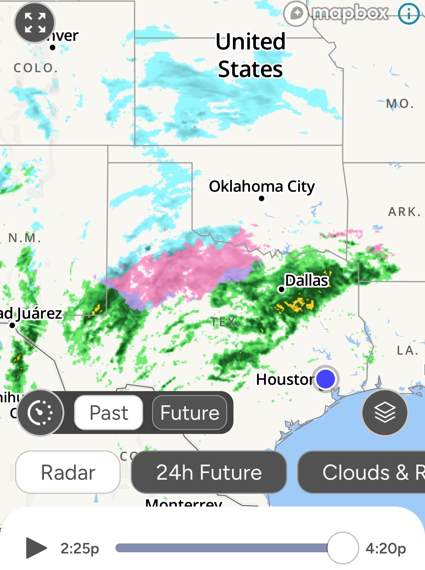
Wingsofwonder, teatime and Kittle + 1 more reacted
|
|
Latest HRRR model for ice accumulation. If we get these type of numbers, tree damage will be possible, which can effect electricity. All it takes it .25 of ice for that to happen. 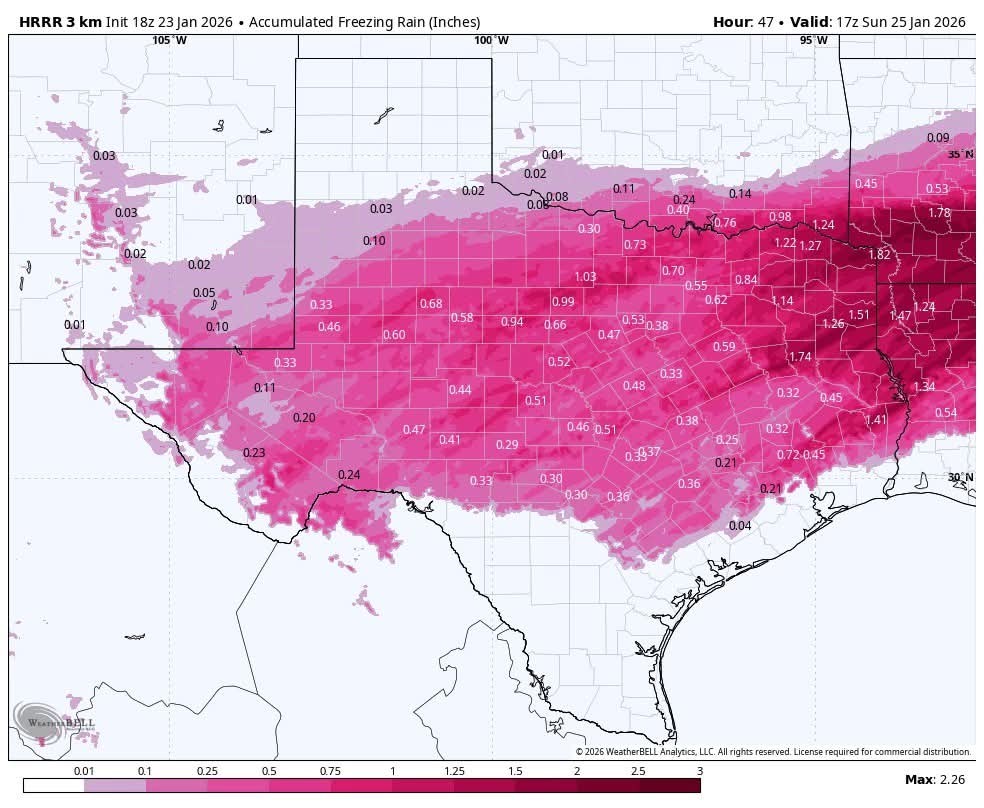
Wingsofwonder, teatime and Kittle + 1 more reacted
|
|
1-26-23 545pm Road condtions are quickly deteriorating across NW Tx where a mix of freezing rain and sleet is currently occurring. Wichita Falls is currently 26 with mixed precipitation Freezing rain will expand southward and east overnight with travel becoming increasingly dangerous across large portions of the state into Saturday. 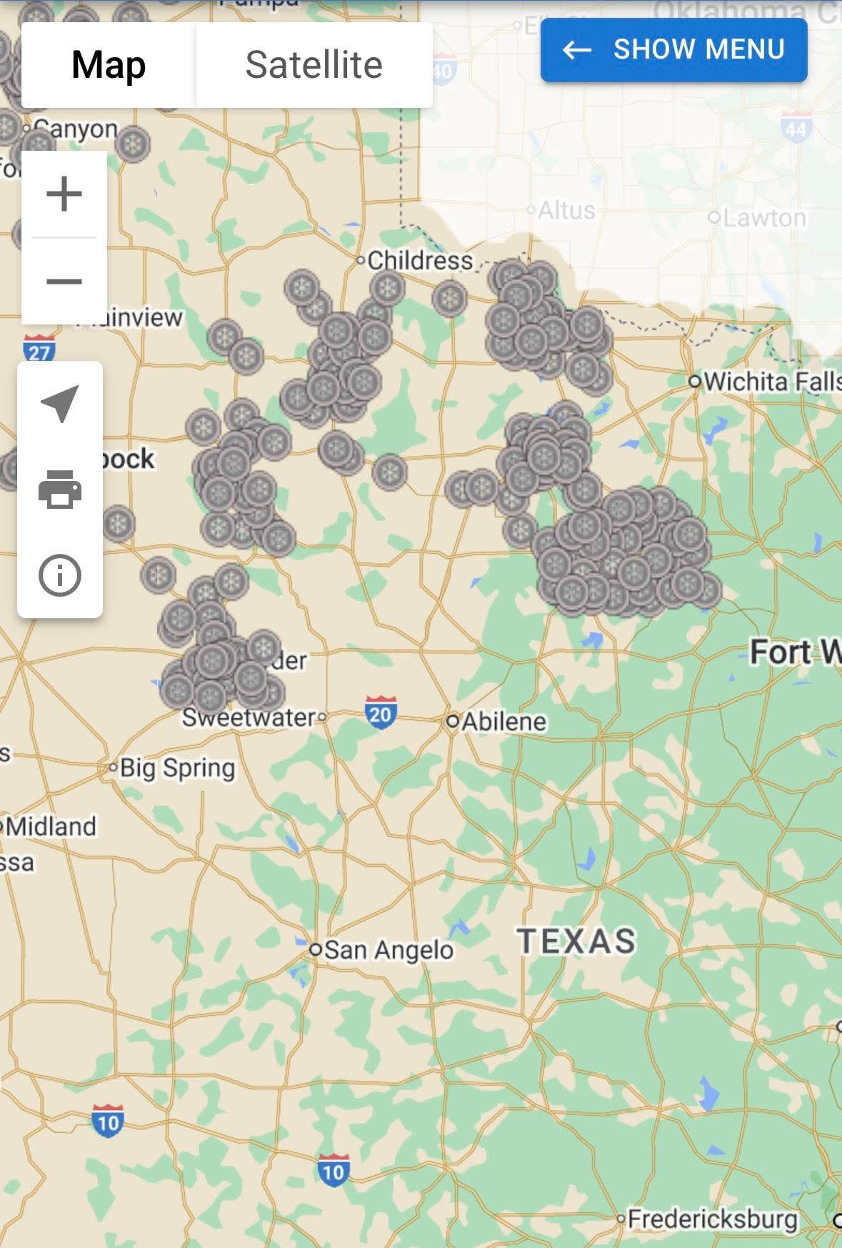
Wingsofwonder, teatime and Kittle reacted
|
|
This shows us getting some type of frozen precipitation from Midnight (early) Sunday AM until 2:30PM! That's 14+ hours 😳 www.facebook.com/sha re/v/18Kvtj7dqZ/
Wingsofwonder reacted « Back to Chat
Views: 1,839
# Replies: 27