


Weekend forecast (Sat storms)
Weekend forecast (Sat storms)


Joined:
X days ago
# Posts:
X,XXX
Contributor Points:
X


Weekend forecast (Sat storms) Rain expected during the day on Saturday with a line of severe storms possible on in the evening. Gusty winds, hail & heavy rainfall are the biggest threat. ....................... Roses are red, violets are blue, some Valentine's storms are in Houston's view. ❤️ Matt Lanza · Friday, February 13, 2026 8:18 AM In brief: *We expect some showers and thunderstorms on Saturday in Houston, a couple of which could be on the stronger side.
*Outside of that, we have nice weather to close the weekend, and another warming trend in store next week. Got Valentine's......or anti-Valentine's Day plans on Saturday? Be sure to include an umbrella as part of your fancy attire. We've got the details on some storms this weekend. TODAY - *Keep your eyes open for fog this morning. It's a prevalent pest across the southeast half of the area, and it's locally dense in spots. It will slowly lift through morning, but fog may cling to Galveston Island or around the bay for much of Friday.
*Otherwise, it'll be warm and humid today with highs in the 70s to near 80 inland and cooler at the coast. SATURDAY ❤️❤️❤️❤️ *Through midday Saturday, all looks well. A few sprinkles or showers, as well as some continued fog is a possibility but otherwise it'll be fine.
*Round one of showers or a few thunderstorms may arrive around mid to late afternoon. None of these are expected to be significant.
*It's the second round that arrives in the evening, probably between 6 and 10 PM or so that may have some noisy, stronger storms. 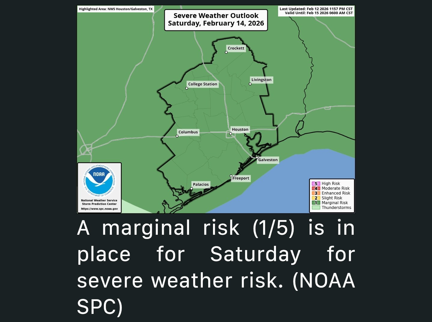 *The entire region is carpeted in a marginal risk, level 1/5, for severe weather tomorrow, which generally means lower-end coverage of severe storms.
*Many locations will hear thunder, but only one or two may see a severe storm with gusty winds.
*Storms should exit the coast around or before midnight, ending any severe threat,
*The chance of a severe storm may be highest north of I-10 tomorrow. 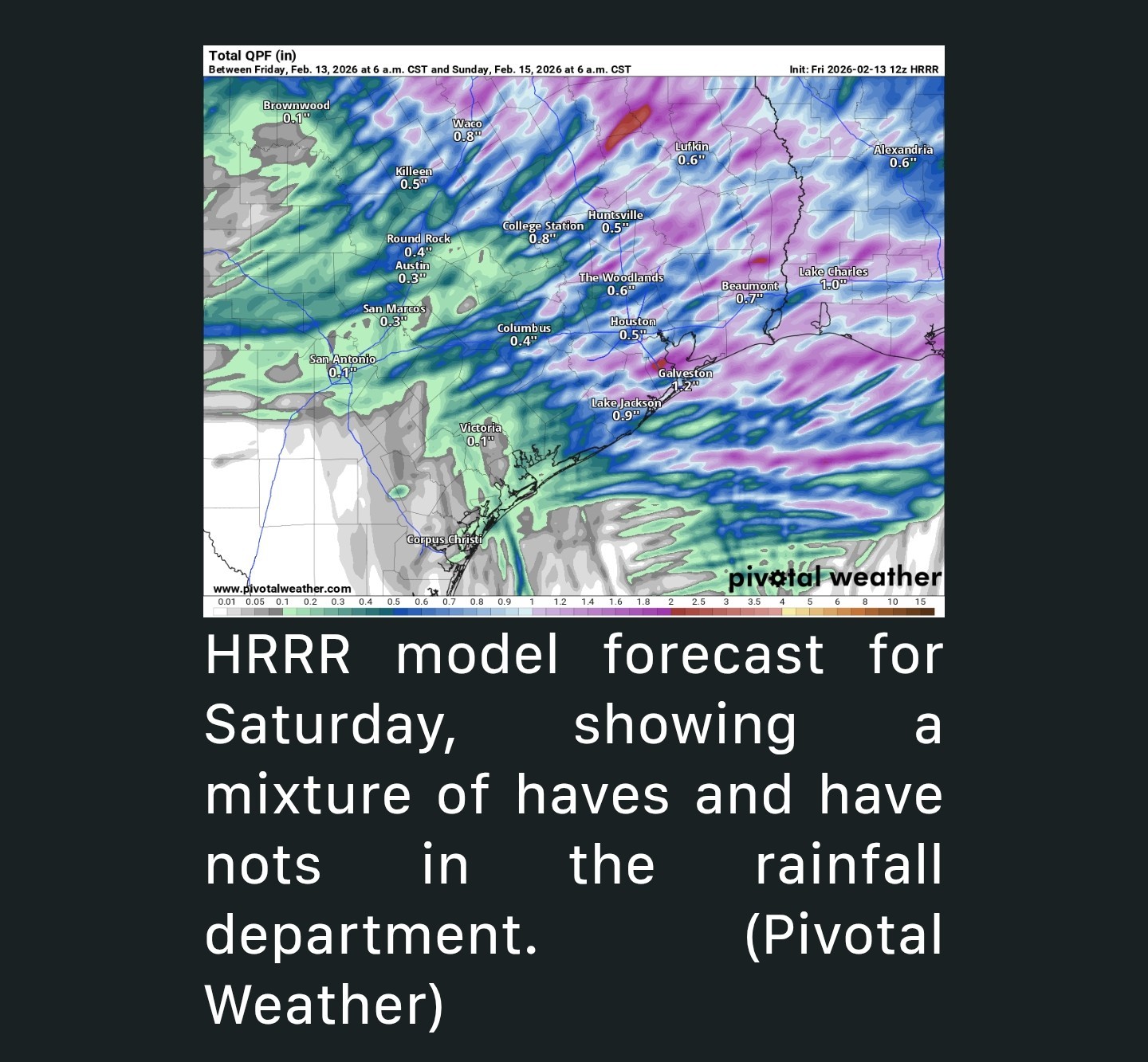 *In addition, some locally heavy rain is likely tomorrow, with a few spots perhaps seeing 2 inches of rain, while others see a quarter inch.
*Basically, have an umbrella, and if you hear thunder, retreat to a safe indoor location.
*Otherwise, look for clouds, some sun, and some fog with highs in the 70s. SUNDAY & WASHINGTON'S BIRTHDAY - *We should clear out and have a picture-perfect Sunday and Presidents' Day Monday.
*Sunday looks glorious with sunshine and highs in the low-70s, although a bit on the breezy side at times with north winds gusting to 20 to 25 mph or so.
*Monday morning will start in the 40s and 50s, warming into the 70s again with pleasant humidity and sunshine.


HappyDay2016, golfshot and RolloTomaso + 8 more reacted *Outside of that, we have nice weather to close the weekend, and another warming trend in store next week.
*Otherwise, it'll be warm and humid today with highs in the 70s to near 80 inland and cooler at the coast.
*Round one of showers or a few thunderstorms may arrive around mid to late afternoon. None of these are expected to be significant.
*It's the second round that arrives in the evening, probably between 6 and 10 PM or so that may have some noisy, stronger storms.
*Many locations will hear thunder, but only one or two may see a severe storm with gusty winds.
*Storms should exit the coast around or before midnight, ending any severe threat,
*The chance of a severe storm may be highest north of I-10 tomorrow.
*Basically, have an umbrella, and if you hear thunder, retreat to a safe indoor location.
*Otherwise, look for clouds, some sun, and some fog with highs in the 70s.
*Sunday looks glorious with sunshine and highs in the low-70s, although a bit on the breezy side at times with north winds gusting to 20 to 25 mph or so.
*Monday morning will start in the 40s and 50s, warming into the 70s again with pleasant humidity and sunshine.
Replies:

|

Weekend forecast (Sat storms) Rain expected during the day on Saturday with a line of severe storms possible on in the evening. Gusty winds, hail & heavy rainfall are the biggest threat. ....................... Roses are red, violets are blue, some Valentine's storms are in Houston's view. ❤️ Matt Lanza · Friday, February 13, 2026 8:18 AM In brief: *We expect some showers and thunderstorms on Saturday in Houston, a couple of which could be on the stronger side. *Outside of that, we have nice weather to close the weekend, and another warming trend in store next week. Got Valentine's......or anti-Valentine's Day plans on Saturday? Be sure to include an umbrella as part of your fancy attire. We've got the details on some storms this weekend. TODAY - *Keep your eyes open for fog this morning. It's a prevalent pest across the southeast half of the area, and it's locally dense in spots. It will slowly lift through morning, but fog may cling to Galveston Island or around the bay for much of Friday. *Otherwise, it'll be warm and humid today with highs in the 70s to near 80 inland and cooler at the coast. SATURDAY ❤️❤️❤️❤️ *Through midday Saturday, all looks well. A few sprinkles or showers, as well as some continued fog is a possibility but otherwise it'll be fine. *Round one of showers or a few thunderstorms may arrive around mid to late afternoon. None of these are expected to be significant. *It's the second round that arrives in the evening, probably between 6 and 10 PM or so that may have some noisy, stronger storms. *The entire region is carpeted in a marginal risk, level 1/5, for severe weather tomorrow, which generally means lower-end coverage of severe storms. *Many locations will hear thunder, but only one or two may see a severe storm with gusty winds. *Storms should exit the coast around or before midnight, ending any severe threat, *The chance of a severe storm may be highest north of I-10 tomorrow. *In addition, some locally heavy rain is likely tomorrow, with a few spots perhaps seeing 2 inches of rain, while others see a quarter inch. *Basically, have an umbrella, and if you hear thunder, retreat to a safe indoor location. *Otherwise, look for clouds, some sun, and some fog with highs in the 70s. SUNDAY & WASHINGTON'S BIRTHDAY - *We should clear out and have a picture-perfect Sunday and Presidents' Day Monday. *Sunday looks glorious with sunshine and highs in the low-70s, although a bit on the breezy side at times with north winds gusting to 20 to 25 mph or so. *Monday morning will start in the 40s and 50s, warming into the 70s again with pleasant humidity and sunshine.
StormChaser : No to the wind and hail. Yes to the rainfall!! Sorry for those who are out celebrating Valentines day and get a bit soggy.
|
|
StormChaser : Thank you for the information and weather updates. I'll be glad to get some rain, but hopefully no flooding. Looks like the temps will continue to be mild, which I'm happy about. Hope you have a great day and weekend ahead!
StormChaser: I appreciate your update. Have a fantastic day.
|
|
StormChaser : Thanks for the update. Hopefully just some nice rain and none of the severe.
|
|
StormChaser : I'm ready for some cooler and less humid weather. I'm ok with storms Saturday night. Good sleeping weather.
|
|
Storm timing for Valentine's Day still looks like an evening impact: 5p-11pm from north to south. I've attached the sequence for the front passing below, should be some good boomers and soakers coming through. 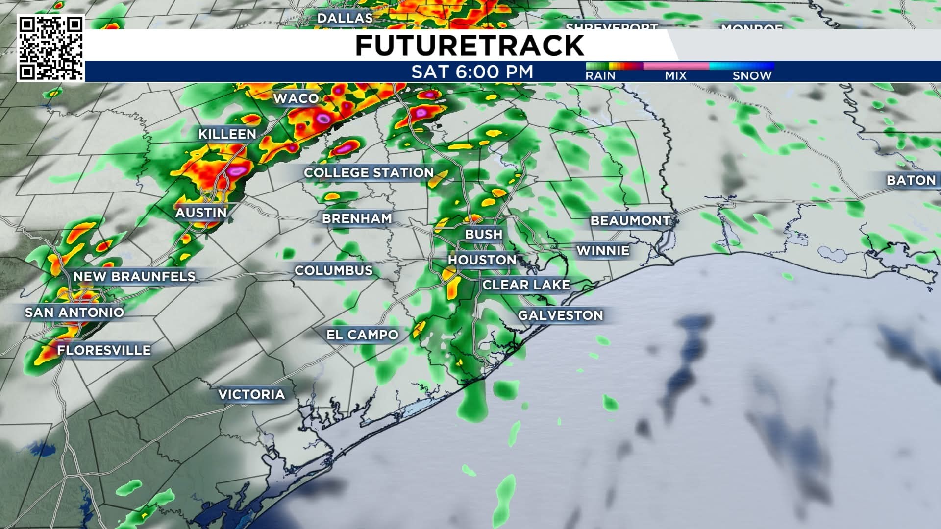
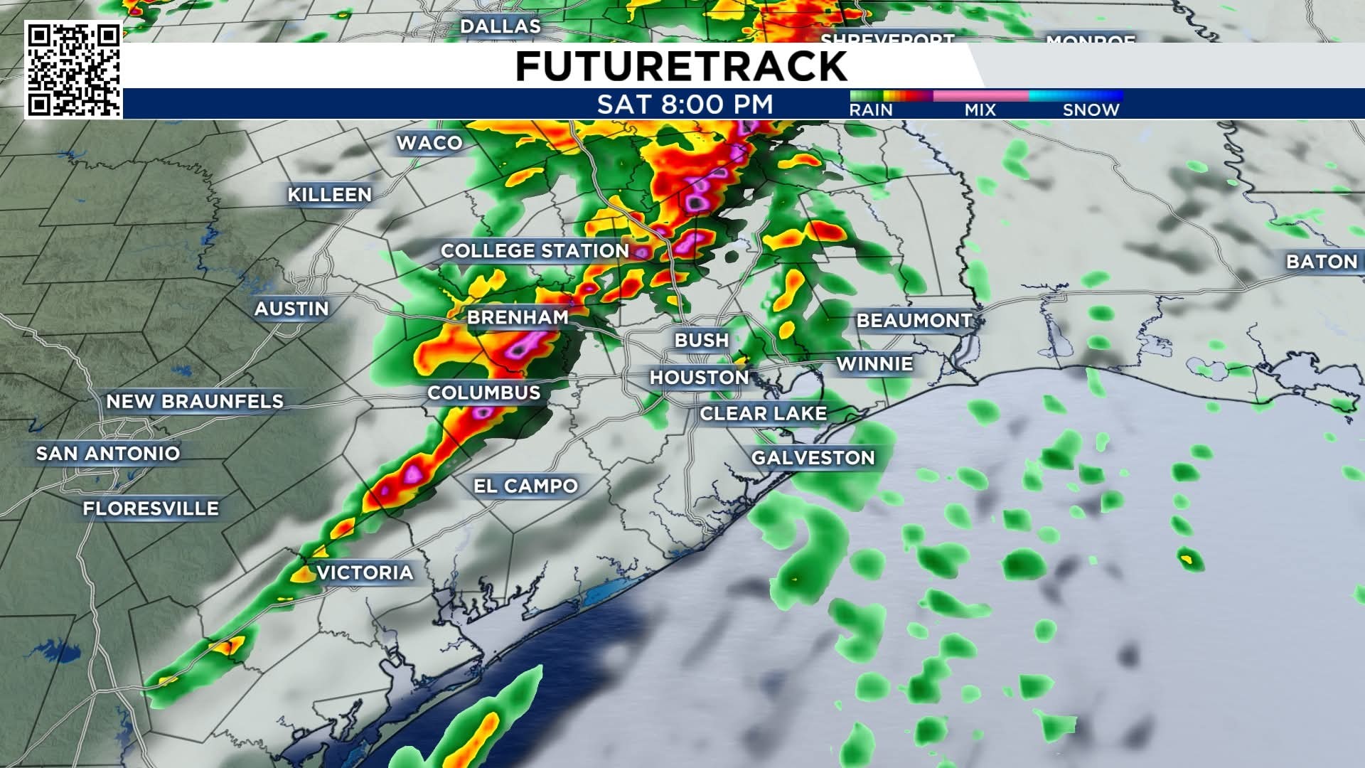
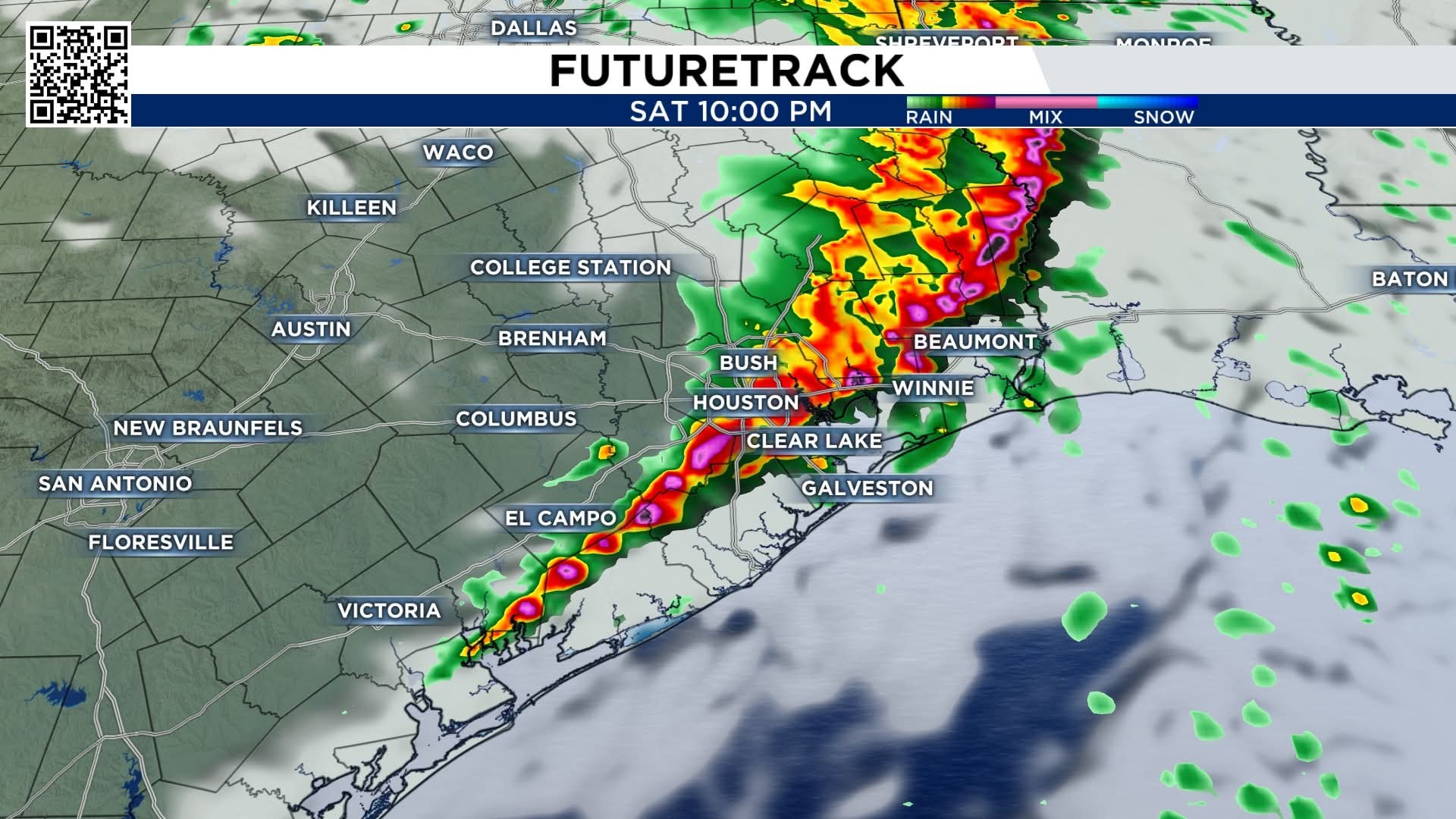
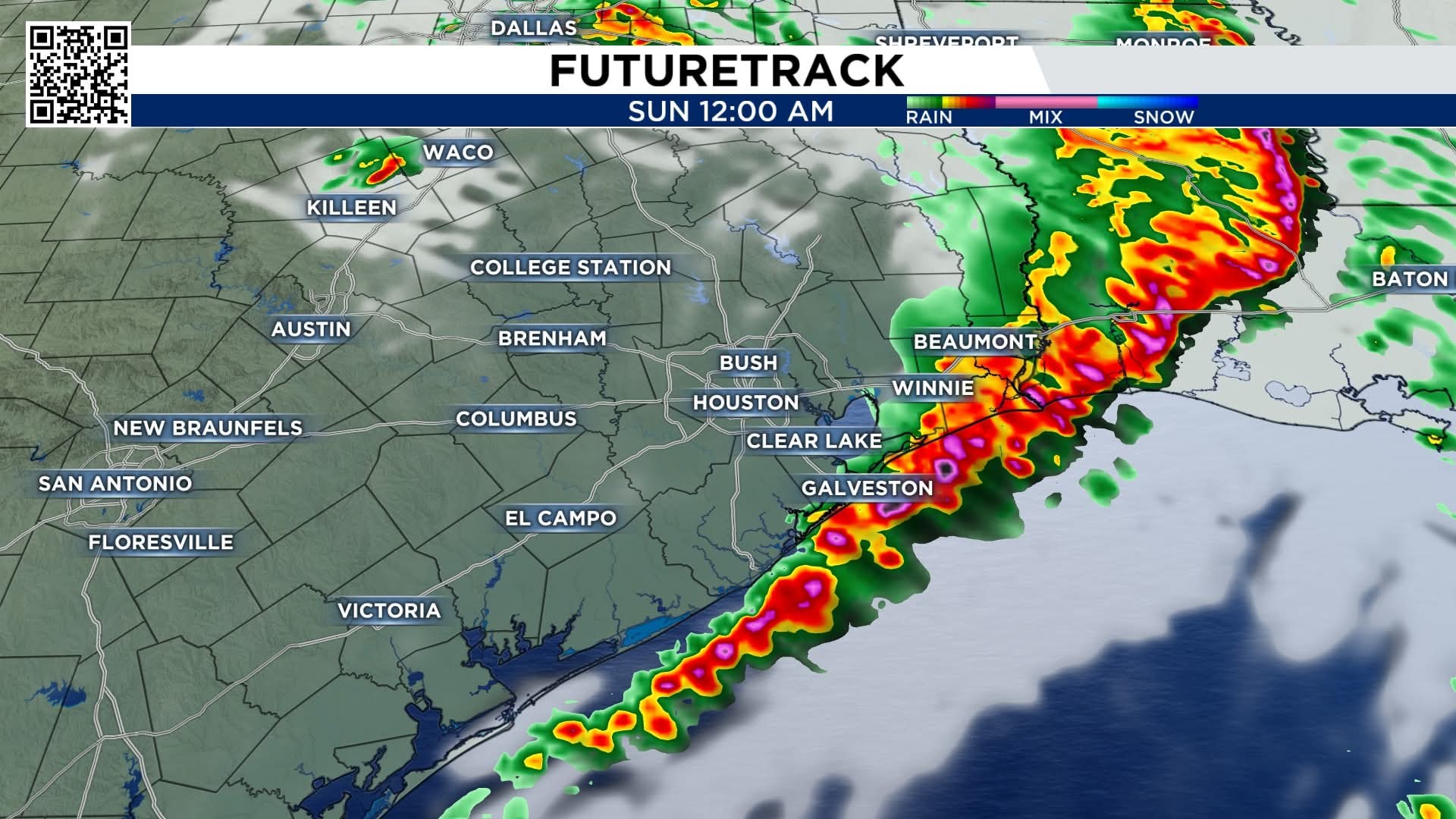
teatime and Gammyof2 reacted
Thank you I just need it to hold off until tomorrow evening after selling all my things out of
House.
House.
|
|
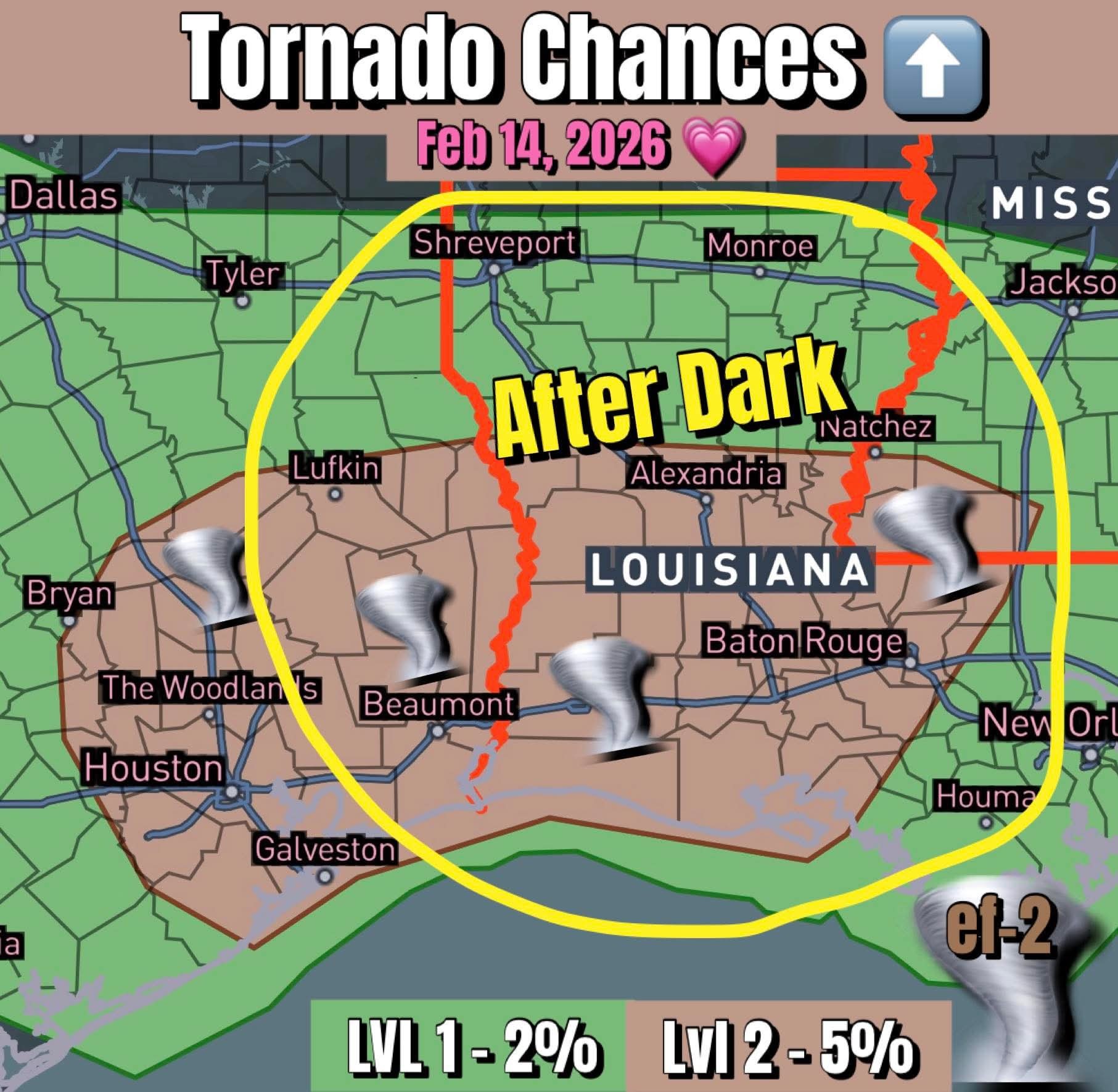
UPDATE: Portions of the area (generally east of a line from College Station to Freeport) have been upgraded to a level 2 out of 5 severe risk for Saturday late afternoon and evening. All severe modes (damaging winds, large hail, and isolated tornadoes) will be possible. Timing for the highest storm threat for Houston metro area is 600-1100pm and 800pm-100am toward the coast and Galveston. 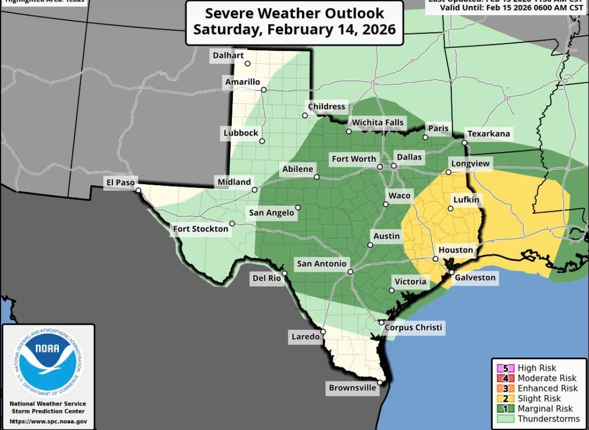
« Back to Chat
Views: 412
# Replies: 14