


Wednesday forecast
Wednesday forecast


Joined:
X days ago
# Posts:
X,XXX
Contributor Points:
X


Wednesday forecast Scattered showers and a few possible isolated storms possible today. *A fairly weak storm system has traversed the region this morning & will bring scattered showers today, mostly - but not exclusively - to our coastal region.
*Overall accumulations don't look to impressive, but we might see a few brief bursts of moderately strong showers.
*I expect the rains to clear out this afternoon or the evening by the latest. *Otherwise, we should have a mostly cloudy day with highs in the upper 60s.
*Winds will be light, generally from the east.
*Lows tonight will only fall into the low 60s.
*Given the fairly high dewpoints, we can probably expect to see patchy fog develop overnight. ..... 👉 THURSDAY: *Skies should become sunny as the day progresses, and this will allow high temperatures to push into the mid- to upper-70s.
*A cold front will approach from the northwest by Thursday evening, but I don't think there will be much in the way of showers, if any, with its passage.
*Winds will shift to come from the north, and be a bit gusty overnight as drier air moves in.
*Lows on Friday morning will likely drop into the upper 40s. Current radar @ 725AM: 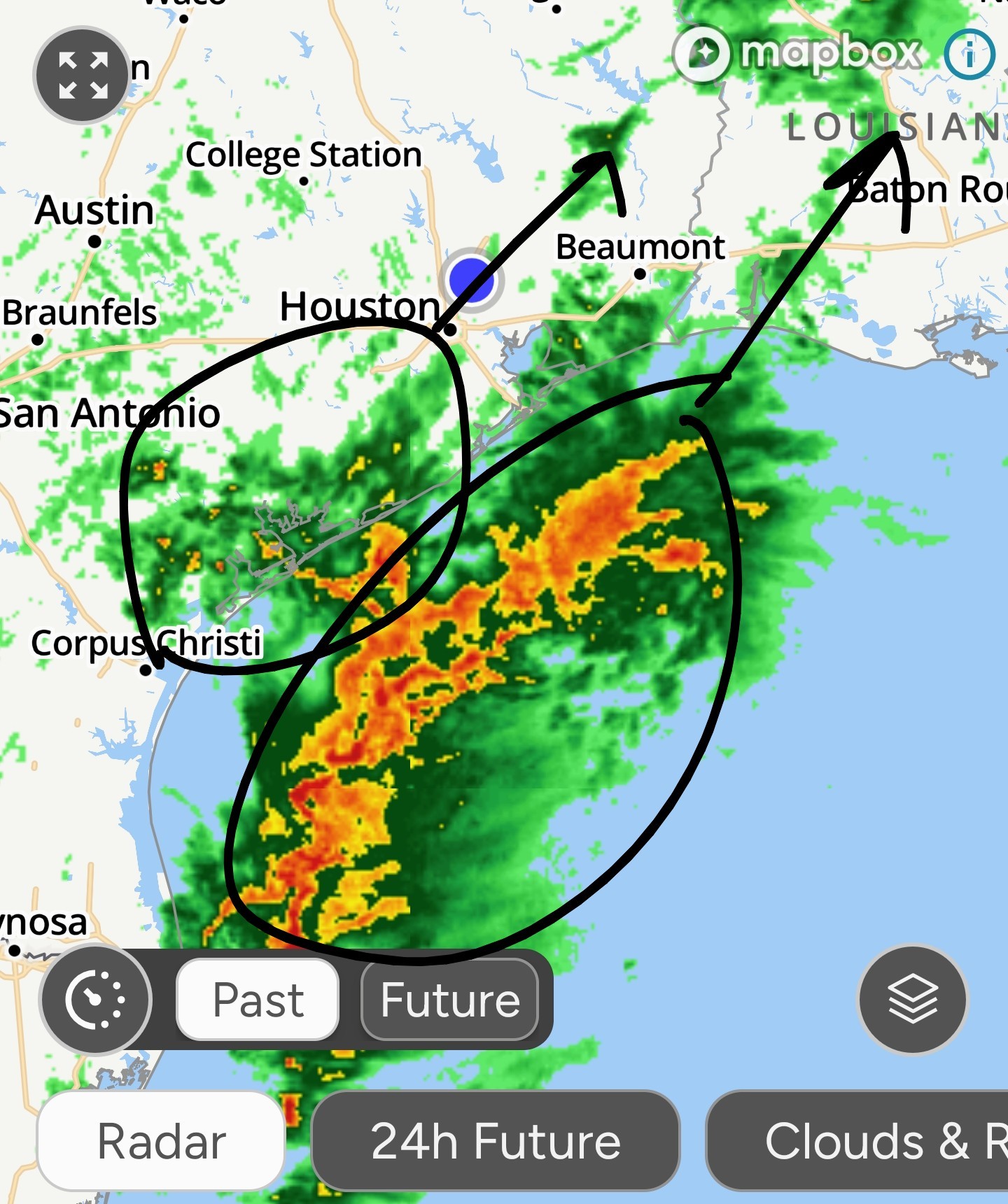 👉 FRIDAY: This will be our last "chilly" day for awhile. *Expect highs in the low to mid 60s with sunny skies and northerly winds.
*This brief incursion of winter-like weather won't last long, however, as winds will already turn southeasterly by Friday afternoon or evening.
*Lows on Friday night should drop into the 50s. 👉 SATURDAY and SUNDAY: *The weekend should see partly to mostly sunny weather, with highs ranging from the mid 70s to about 80 degrees (Sunday looks especially warm).
*Overnight lows will be warm for December, in the mid-60s.
*The air will feel fairly humid, overall.
*On Saturday, as the southerly flow really gets going we could see some winds gusts up to 25 mph. 👉 NEXT WEEK: *As noted previously, there won't be much variance in our weather next week, with highs generally in the range of the upper 70s to 80 degrees, partly sunny skies, and warm nights.
*Rain chances, overall, appear to be fairly low. Will this pattern break? Yes it will, eventually. *Right now, our best models are indicating that our conditions could turn cooler some time around 10 days from now, in the period of December 27 or December 28.
*That really is at the edge of predictability, so it is not a forecast I would feel highly confident in at this time. But hopeful? Certainly. 👉 CHRISTMAS DAY 🎅 *We are now eight days away from the Christmas holiday, and although that lies at the edge of what we would normally consider forecastable, we are pretty confident about the outlook for Christmas Day this year in Houston.
*Beginning this weekend, a rather warm pattern is going to settle over Texas (and much of the southern United States) and this will persist through much of next week.
*Therefore, the most likely outcome for Christmas in Houston is a partly to mostly sunny day, with high temperatures in the upper 70s. 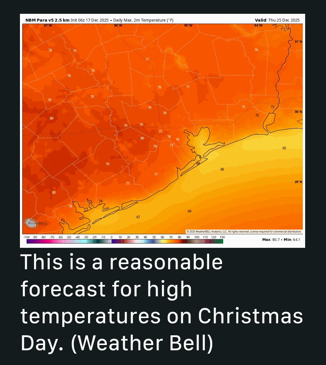 *We cannot entirely rule out rain chances at this point but they look to be low.
*The air will feel fairly humid. 👉🎄 Bottom line: Christmas this year is going to be much warmer than normal, although at this point I think we'll fall just below record high temperatures for late December. 🔥


peppermintstick, SpaceCat and LittleTexas + 5 more reacted *Overall accumulations don't look to impressive, but we might see a few brief bursts of moderately strong showers.
*I expect the rains to clear out this afternoon or the evening by the latest.
*Winds will be light, generally from the east.
*Lows tonight will only fall into the low 60s.
*Given the fairly high dewpoints, we can probably expect to see patchy fog develop overnight.
*A cold front will approach from the northwest by Thursday evening, but I don't think there will be much in the way of showers, if any, with its passage.
*Winds will shift to come from the north, and be a bit gusty overnight as drier air moves in.
*Lows on Friday morning will likely drop into the upper 40s.
*This brief incursion of winter-like weather won't last long, however, as winds will already turn southeasterly by Friday afternoon or evening.
*Lows on Friday night should drop into the 50s.
*Overnight lows will be warm for December, in the mid-60s.
*The air will feel fairly humid, overall.
*On Saturday, as the southerly flow really gets going we could see some winds gusts up to 25 mph.
*Rain chances, overall, appear to be fairly low.
*That really is at the edge of predictability, so it is not a forecast I would feel highly confident in at this time.
*Beginning this weekend, a rather warm pattern is going to settle over Texas (and much of the southern United States) and this will persist through much of next week.
*Therefore, the most likely outcome for Christmas in Houston is a partly to mostly sunny day, with high temperatures in the upper 70s.
*The air will feel fairly humid.
Replies:
StormChaser : thanks for the info. I'd rather have a cold Christmas but we get what we get.
StormChaser : Thank you for continuing to share these forecasts and keeping people informed. It's a little disappointing that Christmas will be warm this year, but I'll take it if it doesn't rain.
StormChaser : Thank you for updating us even when you are sick. Hopefully you are feeling better.
Wednesday forecast Scattered showers and a few possible isolated storms possible today. *A fairly weak storm system has traversed the region this morning & will bring scattered showers today, mostly - but not exclusively - to our coastal region.
*Overall accumulations don't look to impressive, but we might see a few brief bursts of moderately strong showers.
*I expect the rains to clear out this afternoon or the evening by the latest. *Otherwise, we should have a mostly cloudy day with highs in the upper 60s.
*Winds will be light, generally from the east.
*Lows tonight will only fall into the low 60s.
*Given the fairly high dewpoints, we can probably expect to see patchy fog develop overnight. ..... ? THURSDAY: *Skies should become sunny as the day progresses, and this will allow high temperatures to push into the mid- to upper-70s.
*A cold front will approach from the northwest by Thursday evening, but I don't think there will be much in the way of showers, if any, with its passage.
*Winds will shift to come from the north, and be a bit gusty overnight as drier air moves in.
*Lows on Friday morning will likely drop into the upper 40s. Current radar @ 725AM: ? FRIDAY: This will be our last "chilly" day for awhile. *Expect highs in the low to mid 60s with sunny skies and northerly winds.
*This brief incursion of winter-like weather won't last long, however, as winds will already turn southeasterly by Friday afternoon or evening.
*Lows on Friday night should drop into the 50s. ? SATURDAY and SUNDAY: *The weekend should see partly to mostly sunny weather, with highs ranging from the mid 70s to about 80 degrees (Sunday looks especially warm).
*Overnight lows will be warm for December, in the mid-60s.
*The air will feel fairly humid, overall.
*On Saturday, as the southerly flow really gets going we could see some winds gusts up to 25 mph. ? NEXT WEEK: *As noted previously, there won't be much variance in our weather next week, with highs generally in the range of the upper 70s to 80 degrees, partly sunny skies, and warm nights.
*Rain chances, overall, appear to be fairly low. Will this pattern break? Yes it will, eventually. *Right now, our best models are indicating that our conditions could turn cooler some time around 10 days from now, in the period of December 27 or December 28.
*That really is at the edge of predictability, so it is not a forecast I would feel highly confident in at this time. But hopeful? Certainly. ? CHRISTMAS DAY ? *We are now eight days away from the Christmas holiday, and although that lies at the edge of what we would normally consider forecastable, we are pretty confident about the outlook for Christmas Day this year in Houston.
*Beginning this weekend, a rather warm pattern is going to settle over Texas (and much of the southern United States) and this will persist through much of next week.
*Therefore, the most likely outcome for Christmas in Houston is a partly to mostly sunny day, with high temperatures in the upper 70s. *We cannot entirely rule out rain chances at this point but they look to be low.
*The air will feel fairly humid. ?? Bottom line: Christmas this year is going to be much warmer than normal, although at this point I think we'll fall just below record high temperatures for late December. ?
*Overall accumulations don't look to impressive, but we might see a few brief bursts of moderately strong showers.
*I expect the rains to clear out this afternoon or the evening by the latest.
*Winds will be light, generally from the east.
*Lows tonight will only fall into the low 60s.
*Given the fairly high dewpoints, we can probably expect to see patchy fog develop overnight.
*A cold front will approach from the northwest by Thursday evening, but I don't think there will be much in the way of showers, if any, with its passage.
*Winds will shift to come from the north, and be a bit gusty overnight as drier air moves in.
*Lows on Friday morning will likely drop into the upper 40s.
*This brief incursion of winter-like weather won't last long, however, as winds will already turn southeasterly by Friday afternoon or evening.
*Lows on Friday night should drop into the 50s.
*Overnight lows will be warm for December, in the mid-60s.
*The air will feel fairly humid, overall.
*On Saturday, as the southerly flow really gets going we could see some winds gusts up to 25 mph.
*Rain chances, overall, appear to be fairly low.
*That really is at the edge of predictability, so it is not a forecast I would feel highly confident in at this time.
*Beginning this weekend, a rather warm pattern is going to settle over Texas (and much of the southern United States) and this will persist through much of next week.
*Therefore, the most likely outcome for Christmas in Houston is a partly to mostly sunny day, with high temperatures in the upper 70s.
*The air will feel fairly humid.
Kittle tipped StormChaser 100 credits for a post in this forum discussion.
Wednesday forecast Scattered showers and a few possible isolated storms possible today. *A fairly weak storm system has traversed the region this morning & will bring scattered showers today, mostly - but not exclusively - to our coastal region. *Overall accumulations don't look to impressive, but we might see a few brief bursts of moderately strong showers. *I expect the rains to clear out this afternoon or the evening by the latest. *Otherwise, we should have a mostly cloudy day with highs in the upper 60s. *Winds will be light, generally from the east. *Lows tonight will only fall into the low 60s. *Given the fairly high dewpoints, we can probably expect to see patchy fog develop overnight. ..... 👉 THURSDAY: *Skies should become sunny as the day progresses, and this will allow high temperatures to push into the mid- to upper-70s. *A cold front will approach from the northwest by Thursday evening, but I don't think there will be much in the way of showers, if any, with its passage. *Winds will shift to come from the north, and be a bit gusty overnight as drier air moves in. *Lows on Friday morning will likely drop into the upper 40s. Current radar 725AM: 👉 FRIDAY: This will be our last "chilly" day for awhile. *Expect highs in the low to mid 60s with sunny skies and northerly winds. *This brief incursion of winter-like weather won't last long, however, as winds will already turn southeasterly by Friday afternoon or evening. *Lows on Friday night should drop into the 50s. 👉 SATURDAY and SUNDAY: *The weekend should see partly to mostly sunny weather, with highs ranging from the mid 70s to about 80 degrees (Sunday looks especially warm). *Overnight lows will be warm for December, in the mid-60s. *The air will feel fairly humid, overall. *On Saturday, as the southerly flow really gets going we could see some winds gusts up to 25 mph. 👉 NEXT WEEK: *As noted previously, there won't be much variance in our weather next week, with highs generally in the range of the upper 70s to 80 degrees, partly sunny skies, and warm nights. *Rain chances, overall, appear to be fairly low. Will this pattern break? Yes it will, eventually. *Right now, our best models are indicating that our conditions could turn cooler some time around 10 days from now, in the period of December 27 or December 28. *That really is at the edge of predictability, so it is not a forecast I would feel highly confident in at this time. But hopeful? Certainly. 👉 CHRISTMAS DAY 🎅 *We are now eight days away from the Christmas holiday, and although that lies at the edge of what we would normally consider forecastable, we are pretty confident about the outlook for Christmas Day this year in Houston. *Beginning this weekend, a rather warm pattern is going to settle over Texas (and much of the southern United States) and this will persist through much of next week. *Therefore, the most likely outcome for Christmas in Houston is a partly to mostly sunny day, with high temperatures in the upper 70s. *We cannot entirely rule out rain chances at this point but they look to be low. *The air will feel fairly humid. 👉🎄 Bottom line: Christmas this year is going to be much warmer than normal, although at this point I think we'll fall just below record high temperatures for late December. 🔥
StormChaser : All I see so far is some damp driveways and streets. I bet we get left out again! Rrrrrr.
StormChaser : All I see so far is some damp driveways and streets. I bet we get left out again! Rrrrrr.
cbear : Yeah it has mostly stayed at the coast.
« Back to Chat
Views: 331
# Replies: 7