


Weather update - SAT 430 PM
Weather update - SAT 430 PM


Joined:
X days ago
# Posts:
X,XXX
Contributor Points:
X


Weather update - SAT AM *SATURDAY PM UPDATE IN THE COMMENTS* Weather update SAT AM from Jeff Lindner. But first, I want to note a few things. I know we're all focused on the possible thought of snow ❄️ but that really isn't guaranteed nor is it anything to really prepare for. What IS guaranteed is a pipe busting hard freeze that you need to prepare your home for. Headlines this AM:
- The GFS model has pushed the heavy snow line a bit NORTH of here now. Will that change? Too early to know right now.
- Either way, no matter where the snow falls, it's gonna be COLD here and the concern should be about exposed PIPES.
- As of now, temperatures are forecasted to be below freezing for 36-45 hours straight (Monday evening until Wednesday afternoon) with only a brief period above 32° on Wednesday afternoon before we go back below freezing again.
- This amount of time is long enough to cause exposed plumbing to freeze so I'd would ABSOLUTELY take steps to winterize your home just as you did in 2021.
-This event isn't expected to be as bad as '21 but the precautions should be the same. ............. Jeff Lindner 1-18-25 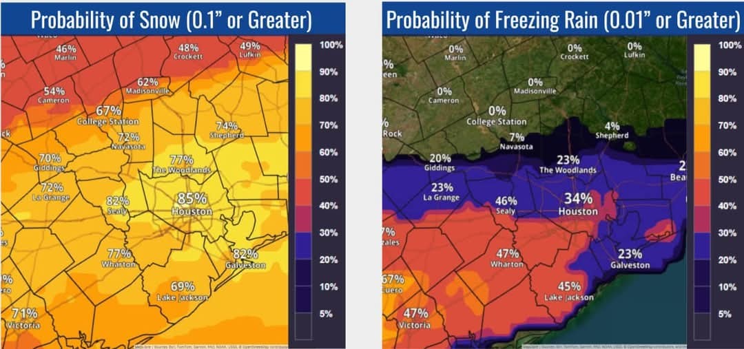 Prolonged period of cold weather including hard freezes likely next week…cold weather advisory in effect for early Sunday.
-Winter storm likely late Monday into late Tuesday.
-Significant travel disruption with near impossible travel on Tuesday.
-The cold front will move through the area this morning followed by increasingly colder conditions into Sunday and next week.
-Clearing skies will help to offset some of the post frontal cooling today followed by a more substantial drop in the temperatures tonight into Sunday.
-Freezing line will enter the area tonight and make it down toward the north and western sides of the metro area Sunday morning and when combined with gusty northerly winds of 15-25mph wind chills will fall into the 10's and 20's for much of the area.
-A Cold Weather Advisory has been issued for the expected low wind chill values on Sunday morning.
-More significant freeze is likely Monday AM with lows into the 20's for much of the area and into the low 20's north of HWY 105 with similar lows on Tuesday AM.
-Potentially the coldest night will be Wednesday morning with possible ice/snow cover and clearing skies resulting in maximum cooling conditions.
-Guidance continues to resolve this period a bit better with a trending down of low temperatures.
-Possible much of the area could fall into the upper 10's with the beaches into the mid 20's on Wednesday AM.
🌡️ Other item to consider is the sub-freezing duration of temperatures. -Much of the area looks to fall below freezing Monday early evening and not rise above freezing until Wednesday afternoon and even then it may only be a few degrees above freezing for a few hours.
- This results in sub-freezing duration of potentially 36-45 hours over much of the area and possibly longer.
🌡️ Monday AM Forecasted Low Temperatures: 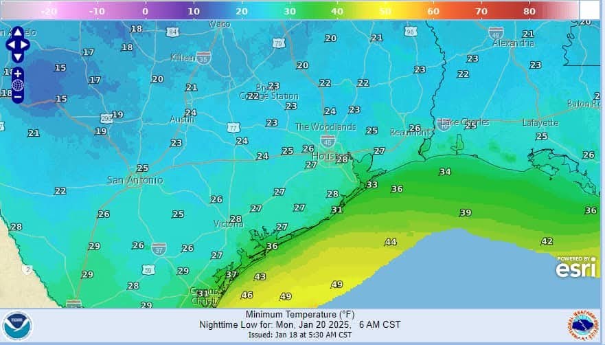 -North of HWY 105: 22-26
-North of I-10: 25-29
-Houston metro (inside Beltway): 27-29
-Coastal Counties: 28-30
-Beaches/Galveston: 31-33 🌡️ Tuesday AM Forecasted Low Temperatures: 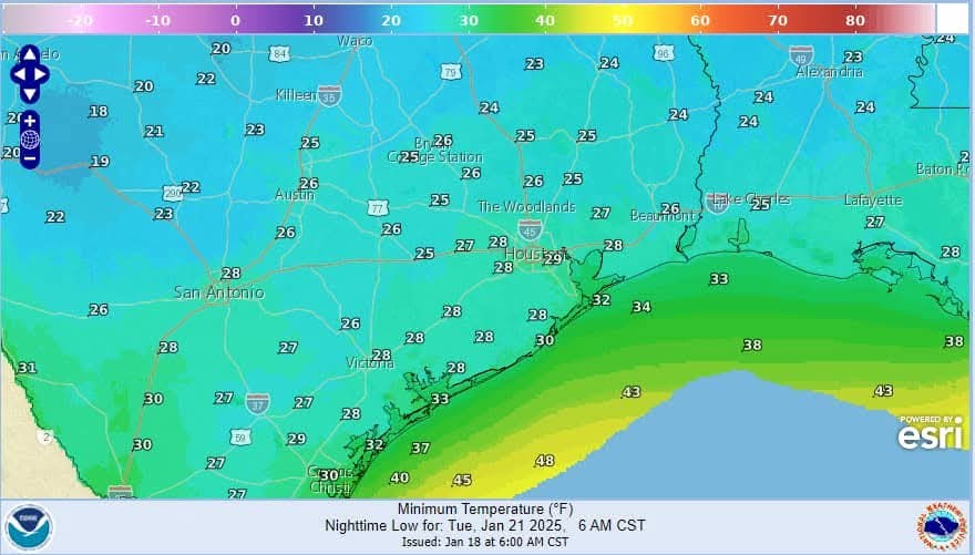 -North of HWY 105: 22-26
-North of I-10: 26-30
-Houston metro (inside Beltway): 27-29
-Coastal Counties: 28-30
-Beaches/Galveston: 30-32 🌡️ Wednesday AM Forecasted Low Temperatures: 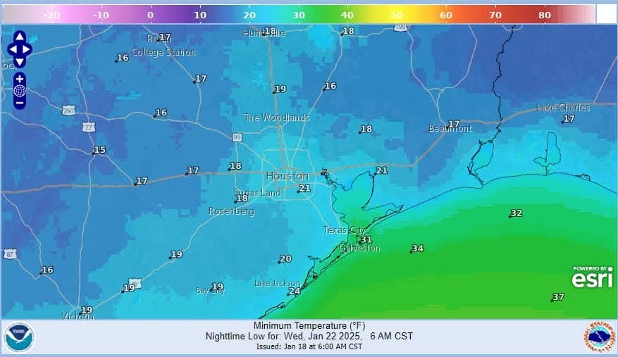 -North of HWY 105: 17-20
-North of I-10: 18-21
-Houston metro (inside Beltway): 19-21
-Coastal Counties: 19-24
-Beaches/Galveston: 30-32 🧊 Maximum preparations and precautions for sub-freezing conditions for many hours should be completed this weekend. -Failure to complete proper precautions may result in significant damage to vegetation and infrastructure.
-Protect sensitive vegetation.
-Protect any exposed outdoor pipes (sprinkler systems should be shut off and properly drained).
-Pipes in attics and along exterior walls of structures could freeze at these levels.
-Prepare proper shelter and warmth for animals and livestock and make sure water sources are not frozen.
-Persons should limit outside exposure to a minimum.
❄️ Winter Precipitation: ❄️ Once the cold air is in place on Monday an upper level trough will move across the state of Texas late Monday through the day on Tuesday.
❄️ This feature will force a surface low along the lower Texas coast that will help to draw moisture northward into the cold air mass.
❄️ Clouds will quickly increase from south to north Monday followed by the development of precipitation late Monday afternoon into the evening hours.
❄️ The GFS model is slightly warmer at the surface and aloft compared to the ECMWF model resulting in more freezing rain/sleet on the GFS and more snow on the EURO. ❄️ This system is starting to come into the range of our more reliable high resolution models and this should help with both Precip type challenges and accumulations over the next 24 hours.
❄️ Will it favor a more snow profile along and north of I-10 with the potential for a mixture of freezing rain/sleet/snow south of I-10? Guidance continues to suggest the potential for mesoscale banding within the precipitation shield that can locally result in much higher totals of precipitation. This has occurred in recent snow events locally in 2004, 2008 and 2009.
❄️ Snow accumulations of 1-3 inches is possible along and north of I-10 with locally higher amounts under banding features.
❄️ Lower amounts south of I-10 to the coast.
❄️ Probabilities of .10 or greater snow: 70-85% for much of the area.
🧊 Probabilities for .01 or greater ice has increased south of I-10 into the 35-50% range.
❗ I will continue to caution that the start of this winter weather event is still 72 hours away and changes in the precipitation and accumulations are ALMOST CERTAIN over that period.
🚗✈️ Impacts: Given surface temperatures will be well below freezing while the precipitation is falling: -Significant travel impacts can be expected initially on elevated surface and eventually surface streets.
-Travel disruption late Monday into early Wednesday will be significant and at times potentially impossible over the area. 🚗 Recovery of area roadways: -Elevated surfaces especially may be slow depending on the amount of accumulation.
-It is possible that the area is still dealing with travel issues into Thursday morning.
-Aviation will be heavily impacted with expected significant delays and cancellations Monday night into Tuesday night.
-De-icing of aircraft will be required and accumulations on runways is likely.


- The GFS model has pushed the heavy snow line a bit NORTH of here now. Will that change? Too early to know right now.
- Either way, no matter where the snow falls, it's gonna be COLD here and the concern should be about exposed PIPES.
- As of now, temperatures are forecasted to be below freezing for 36-45 hours straight (Monday evening until Wednesday afternoon) with only a brief period above 32° on Wednesday afternoon before we go back below freezing again.
- This amount of time is long enough to cause exposed plumbing to freeze so I'd would ABSOLUTELY take steps to winterize your home just as you did in 2021.
-This event isn't expected to be as bad as '21 but the precautions should be the same.
-Winter storm likely late Monday into late Tuesday.
-Significant travel disruption with near impossible travel on Tuesday.
-The cold front will move through the area this morning followed by increasingly colder conditions into Sunday and next week.
-Clearing skies will help to offset some of the post frontal cooling today followed by a more substantial drop in the temperatures tonight into Sunday.
-Freezing line will enter the area tonight and make it down toward the north and western sides of the metro area Sunday morning and when combined with gusty northerly winds of 15-25mph wind chills will fall into the 10's and 20's for much of the area.
-A Cold Weather Advisory has been issued for the expected low wind chill values on Sunday morning.
-More significant freeze is likely Monday AM with lows into the 20's for much of the area and into the low 20's north of HWY 105 with similar lows on Tuesday AM.
-Potentially the coldest night will be Wednesday morning with possible ice/snow cover and clearing skies resulting in maximum cooling conditions.
-Guidance continues to resolve this period a bit better with a trending down of low temperatures.
-Possible much of the area could fall into the upper 10's with the beaches into the mid 20's on Wednesday AM.
🌡️ Other item to consider is the sub-freezing duration of temperatures.
- This results in sub-freezing duration of potentially 36-45 hours over much of the area and possibly longer.
🌡️ Monday AM Forecasted Low Temperatures:
-North of I-10: 25-29
-Houston metro (inside Beltway): 27-29
-Coastal Counties: 28-30
-Beaches/Galveston: 31-33
-North of I-10: 26-30
-Houston metro (inside Beltway): 27-29
-Coastal Counties: 28-30
-Beaches/Galveston: 30-32
-North of I-10: 18-21
-Houston metro (inside Beltway): 19-21
-Coastal Counties: 19-24
-Beaches/Galveston: 30-32
-Protect sensitive vegetation.
-Protect any exposed outdoor pipes (sprinkler systems should be shut off and properly drained).
-Pipes in attics and along exterior walls of structures could freeze at these levels.
-Prepare proper shelter and warmth for animals and livestock and make sure water sources are not frozen.
-Persons should limit outside exposure to a minimum.
❄️ Winter Precipitation:
❄️ This feature will force a surface low along the lower Texas coast that will help to draw moisture northward into the cold air mass.
❄️ Clouds will quickly increase from south to north Monday followed by the development of precipitation late Monday afternoon into the evening hours.
❄️ The GFS model is slightly warmer at the surface and aloft compared to the ECMWF model resulting in more freezing rain/sleet on the GFS and more snow on the EURO.
❄️ Will it favor a more snow profile along and north of I-10 with the potential for a mixture of freezing rain/sleet/snow south of I-10? Guidance continues to suggest the potential for mesoscale banding within the precipitation shield that can locally result in much higher totals of precipitation. This has occurred in recent snow events locally in 2004, 2008 and 2009.
❄️ Snow accumulations of 1-3 inches is possible along and north of I-10 with locally higher amounts under banding features.
❄️ Lower amounts south of I-10 to the coast.
❄️ Probabilities of .10 or greater snow: 70-85% for much of the area.
🧊 Probabilities for .01 or greater ice has increased south of I-10 into the 35-50% range.
❗ I will continue to caution that the start of this winter weather event is still 72 hours away and changes in the precipitation and accumulations are ALMOST CERTAIN over that period.
🚗✈️ Impacts:
-Travel disruption late Monday into early Wednesday will be significant and at times potentially impossible over the area.
-It is possible that the area is still dealing with travel issues into Thursday morning.
-Aviation will be heavily impacted with expected significant delays and cancellations Monday night into Tuesday night.
-De-icing of aircraft will be required and accumulations on runways is likely.
Discussion Summary:
"Severe Winter Weather Advisory: Preparing for Prolonged Freeze and Potential Snow Across the Region"
"Severe Winter Weather Advisory: Preparing for Prolonged Freeze and Potential Snow Across the Region"
Discussion Insights:
Ask a question about this discussion and an AI bot will try to give an answer.
Ask a question about this discussion and an AI bot will try to give an answer.
Replies:
We are very appreciative of your detailed weather updates. Keep 'em coming - thank you.

|
Space City Weather update SAT 8AM: A front is pushing into the Houston metro area this morning, and it will begin a week-long period of much colder weather, with hard freezes likely on multiple mornings, and a probable winter storm that will significantly disrupt mobility around the region on Tuesday and possibly Wednesday. In short, we expect roads to be a mess on Tuesday, and with freezing temperatures on Tuesday night, probably well into Wednesday morning. I would expect significant impacts to air travel as well during this period. spacecityweather.com /winter-storm-still- on-track-to-arrive-i n-houston-monda
StormChaser : thanks for the info. I pray that you and your family are doing well. Stay warm and keep posting, please!!
|
|

Weather update - SAT AM Weather update SAT AM from Jeff Lindner. But first, I want to note a few things. I know we're all focused on the possible thought of snow ❄️ but that really isn't guaranteed nor is it anything to really prepare for. What IS guaranteed is a pipe busting hard freeze that you need to prepare your home for. Headlines this AM: - The GFS model has pushed the heavy snow line a bit NORTH of here now. Will that change? Too early to know right now. - Either way, no matter where the snow falls, it's gonna be COLD here and the concern should be about exposed PIPES. - As of now, temperatures are forecasted to be below freezing for 36-45 hours straight (Monday evening until Wednesday afternoon) with only a brief period above 32° on Wednesday afternoon before we go back below freezing again. - This amount of time is long enough to cause exposed plumbing to freeze so I'd would ABSOLUTELY take steps to winterize your home just as you did in 2021. -This event isn't expected to be as bad as '21 but the precautions should be the same. ............. Jeff Lindner 1-18-25 Prolonged period of cold weather including hard freezes likely next week…cold weather advisory in effect for early Sunday. -Winter storm likely late Monday into late Tuesday. -Significant travel disruption with near impossible travel on Tuesday. -The cold front will move through the area this morning followed by increasingly colder conditions into Sunday and next week. -Clearing skies will help to offset some of the post frontal cooling today followed by a more substantial drop in the temperatures tonight into Sunday. -Freezing line will enter the area tonight and make it down toward the north and western sides of the metro area Sunday morning and when combined with gusty northerly winds of 15-25mph wind chills will fall into the 10's and 20's for much of the area. -A Cold Weather Advisory has been issued for the expected low wind chill values on Sunday morning. -More significant freeze is likely Monday AM with lows into the 20's for much of the area and into the low 20's north of HWY 105 with similar lows on Tuesday AM. -Potentially the coldest night will be Wednesday morning with possible ice/snow cover and clearing skies resulting in maximum cooling conditions. -Guidance continues to resolve this period a bit better with a trending down of low temperatures. -Possible much of the area could fall into the upper 10's with the beaches into the mid 20's on Wednesday AM. 🌡️ Other item to consider is the sub-freezing duration of temperatures. -Much of the area looks to fall below freezing Monday early evening and not rise above freezing until Wednesday afternoon and even then it may only be a few degrees above freezing for a few hours. - This results in sub-freezing duration of potentially 36-45 hours over much of the area and possibly longer. 🌡️ Monday AM Forecasted Low Temperatures: -North of HWY 105: 22-26 -North of I-10: 25-29 -Houston metro (inside Beltway): 27-29 -Coastal Counties: 28-30 -Beaches/Galveston: 31-33 🌡️ Tuesday AM Forecasted Low Temperatures: -North of HWY 105: 22-26 -North of I-10: 26-30 -Houston metro (inside Beltway): 27-29 -Coastal Counties: 28-30 -Beaches/Galveston: 30-32 🌡️ Wednesday AM Forecasted Low Temperatures: -North of HWY 105: 17-20 -North of I-10: 18-21 -Houston metro (inside Beltway): 19-21 -Coastal Counties: 19-24 -Beaches/Galveston: 30-32 🧊 Maximum preparations and precautions for sub-freezing conditions for many hours should be completed this weekend. -Failure to complete proper precautions may result in significant damage to vegetation and infrastructure. -Protect sensitive vegetation. -Protect any exposed outdoor pipes (sprinkler systems should be shut off and properly drained). -Pipes in attics and along exterior walls of structures could freeze at these levels. -Prepare proper shelter and warmth for animals and livestock and make sure water sources are not frozen. -Persons should limit outside exposure to a minimum. ❄️ Winter Precipitation: ❄️ Once the cold air is in place on Monday an upper level trough will move across the state of Texas late Monday through the day on Tuesday. ❄️ This feature will force a surface low along the lower Texas coast that will help to draw moisture northward into the cold air mass. ❄️ Clouds will quickly increase from south to north Monday followed by the development of precipitation late Monday afternoon into the evening hours. ❄️ The GFS model is slightly warmer at the surface and aloft compared to the ECMWF model resulting in more freezing rain/sleet on the GFS and more snow on the EURO. ❄️ This system is starting to come into the range of our more reliable high resolution models and this should help with both Precip type challenges and accumulations over the next 24 hours. ❄️ Will it favor a more snow profile along and north of I-10 with the potential for a mixture of freezing rain/sleet/snow south of I-10? Guidance continues to suggest the potential for mesoscale banding within the precipitation shield that can locally result in much higher totals of precipitation. This has occurred in recent snow events locally in 2004, 2008 and 2009. ❄️ Snow accumulations of 1-3 inches is possible along and north of I-10 with locally higher amounts under banding features. ❄️ Lower amounts south of I-10 to the coast. ❄️ Probabilities of .10 or greater snow: 70-85% for much of the area. 🧊 Probabilities for .01 or greater ice has increased south of I-10 into the 35-50% range. ❗ I will continue to caution that the start of this winter weather event is still 72 hours away and changes in the precipitation and accumulations are ALMOST CERTAIN over that period. 🚗✈️ Impacts: Given surface temperatures will be well below freezing while the precipitation is falling: -Significant travel impacts can be expected initially on elevated surface and eventually surface streets. -Travel disruption late Monday into early Wednesday will be significant and at times potentially impossible over the area. 🚗 Recovery of area roadways: -Elevated surfaces especially may be slow depending on the amount of accumulation. -It is possible that the area is still dealing with travel issues into Thursday morning. -Aviation will be heavily impacted with expected significant delays and cancellations Monday night into Tuesday night. -De-icing of aircraft will be required and accumulations on runways is likely.
StormChaser : Thank you. Not looking forward to tomorrow until..who knows when. My pipes are wrapped and coverd with blankets etc but, I think they may be a bit damp so I am doing to remove and dry thoroughly before putting them back on. Opening cabinets under sinks, starting the drip, checking out the attic and ....run the dang pool for who knows how long. So, I of course will be expecting a high gas bill and.....a higher than normal light bill for running the pool pump endlessly. Not too worried about a high water bill since it is just a drip.
|
|
StormChaser : Thank you for continuing to provide us with all of this helpful information. I also like to follow Space City Weather because they give us the information we need without all of the hype.
Gotta work, so playing it as it lays. Thanks for the info
I would suggest that if you haven't already, get on line now and order up some heated pipe wrap tape and pipe insulation from Amazon. It's too late for this freeze but this won't be the last time we see freezing weather in the coming season and years to come. It's so easy for me to prepare my house for these freezes now. I simply run an extension cord to my two outdoor outlets and I open the under sink cabinet doors on the sinks on outside walls. That's it. Takes a grand total of about 5 minutes. www.amazon.com/gp/pr oduct/B0002YWM3M?ie= UTF8&th=1 www.amazon.com/gp/pr oduct/B09NRKG8HH?ie= UTF8&th=1
|
|
From Space City Weather: Saturday afternoon update: Snow, sleet, and freezing rain still in the mix. And will the power hold? ❄️🧊🌡️ January 18, 2025 at 4:15 pm by Eric Berger In brief: It is the final hours before the Arctic freeze sets in, and we've got the latest information on what to expect in terms of cold and wintry precipitation, and when to expect it. 🚗 The bottom line is that Tuesday and possibly Wednesday both look very iffy for traveling around Houston. (It could be worse
As I type this, the Houston Texans 🏈 are kicking off against the Kansas City Chiefs in the Divisional round of the NFL Playoffs. Game-time temperatures are in the low 20s, with gusty northwesterly winds. By Tuesday morning the low temperature there is expected to be -1 degree Fahrenheit. So yes, Houston is going to get cold this coming week, but it could always be worse. Also, let's go Texans!) 🌡️ Temperatures will soon begin falling. SAT 430PM: -It's fairly pleasant outside, with temperatures in the low 60s across much of the Houston region but don't be fooled. Winds are steady from the northwest, and as the Sun falls toward the horizon, temperatures will follow.
-Lows tonight will drop to around freezing in Houston, and with gusty northerly winds the apparent temperature will feel as if it is in the low 20s, at least tomorrow morning.
-So if you're joining me at the Houston Marathon, bundle up, wear layers, and use the cold as motivation to go faster. -Despite the cold start, Sunday will be fine in terms of getting out and about. Highs will reach the low- to- mid-40s with sunny skies. 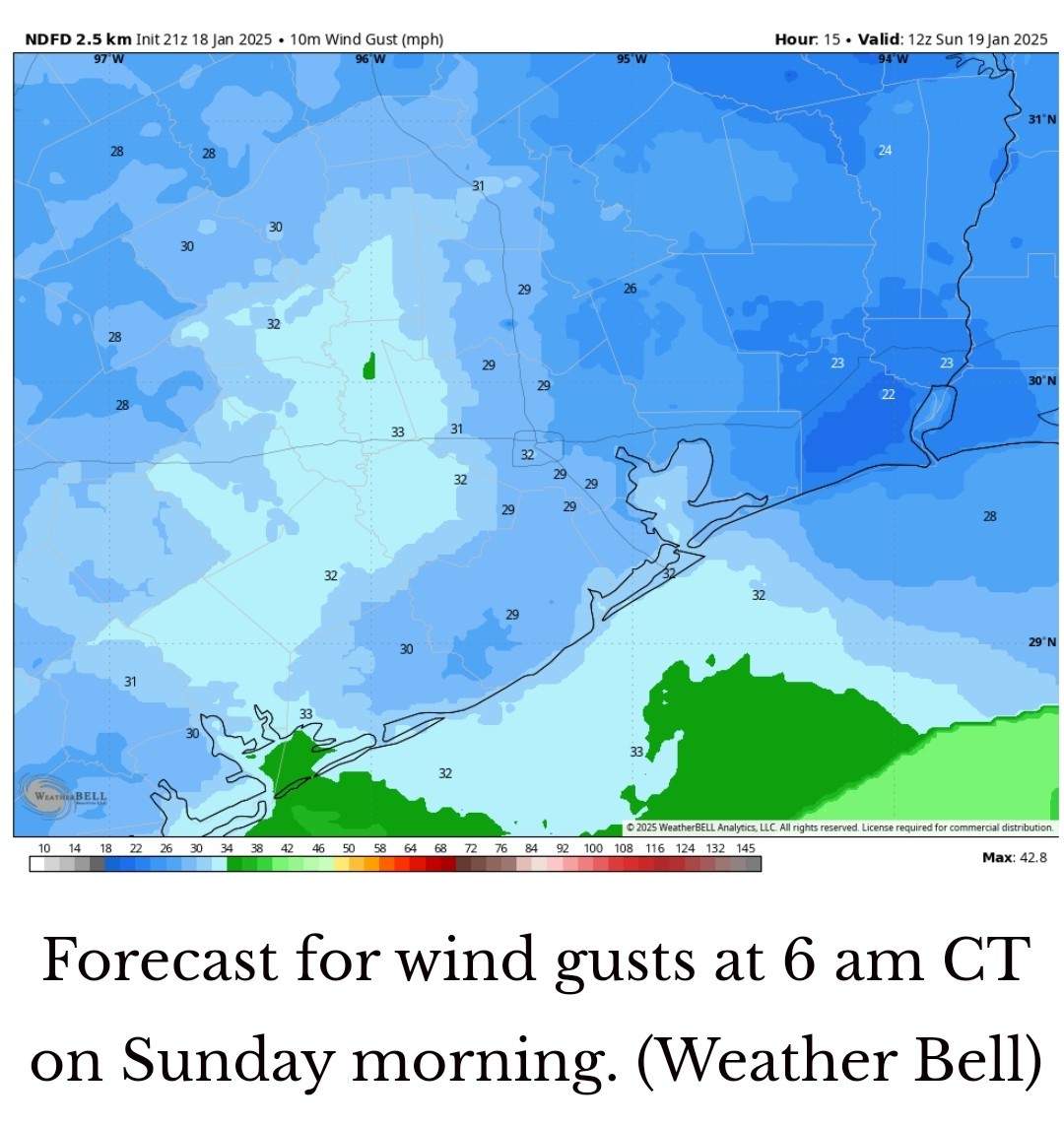 MLK Day - MONDAY -Houston will likely see a light freeze on Monday morning, although some inland areas (i.e. along and north of Highway 105) could see lows drop into the mid- to upper-20s.
-Monday should be mostly fine for any last minute preparations ahead of a winter storm. Highs will be around 40 degrees.
-I'm afraid it's a dreary forecast for MLK Day festivities, with increasing clouds and gusty easterly winds keeping a distinct chill in the air. MONDAY NIGHT THROUGH WEDNESDAY MORNING: ❄️🧊 You should plan to be home by around 9 pm CT or so on Monday❄️🧊 -Although temperatures probably won't fall below freezing until a few hours later, we might start to see some light sleet or snow by around this time.
-Temperatures reach freezing levels by midnight or so, when precipitation coverage should also begin to increase. -This is the point of the forecast where we are still mired in uncertainty. -The key questions are: A.) How much moisture will be available for precipitation to form and fall? and B.) What kind of wintry mix will develop? NEITHER IS ANSWERABLE YET. -For areas along and north of Interstate 10, I continue to think snow is the most likely option (perhaps 1-3 inches, or more), but we could see sleet mixed in.
-For areas south of Interstate 10, sleet may be more likely than snow, although we may still see some snow there.
-Further to the southwest, in Matagorda and Brazoria counties, we may see freezing rain as the dominant precipitation. -The bottom line is that when you wake up on Tuesday, some sort of winter wonderland (or nightmare) is going to exist outside.
-Snow/sleet/freezing rain is likely to continue through the morning hours on Tuesday, and possibly into the early afternoon.
-We may see some partially clearing skies by evening. However, temperatures will struggle to reach above freezing on Tuesday, and if they do in Houston it may only be for an hour or two.
-I don't think we're going to get enough warmth to melt and clear streets. 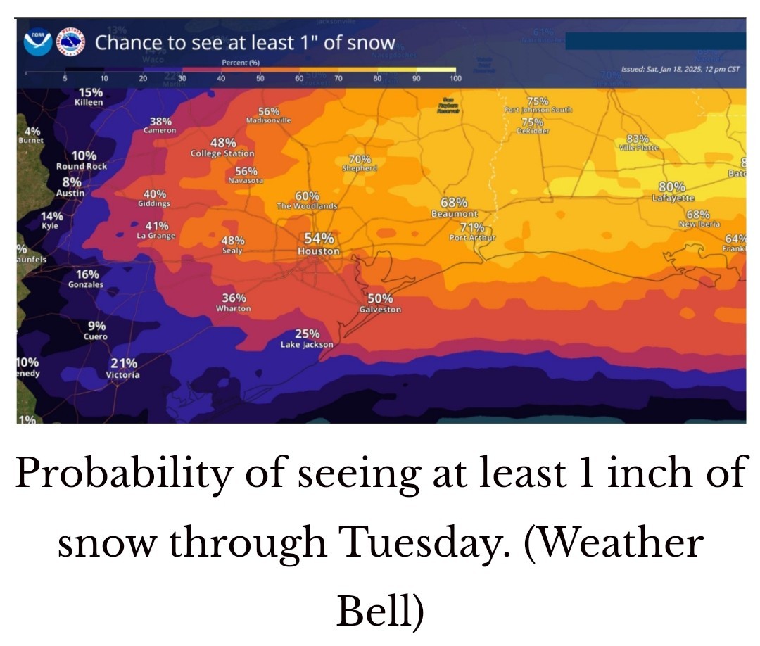 -Depending on how much snow cover there is overnight, temperatures in Houston will either be in the upper teens or lower 20s on Wednesday morning, which will be the coldest of the week.
-Virtually the entire metro area, aside from the coast, is likely to experience a hard freeze.
-This is going to help maintain ice or snow on area roads, and my sense is that Wednesday morning will likely once again be a no-go for traveling around the area.
-By Wednesday afternoon, the combination of (slightly) above freezing temperatures and sunny skies will probably help clear roads but it's still difficult to be certain of this right now. 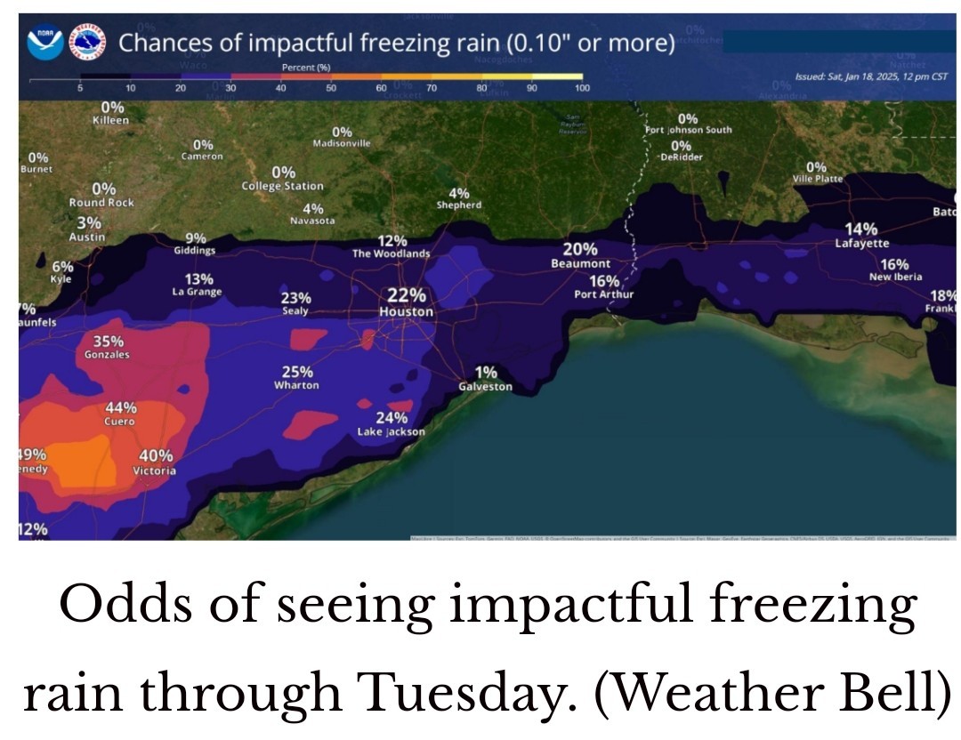 THE END: -Highs finally get back into the mid-to upper-40s on Thursday, so at this time we think Houston will return to normal by that time.
-Next weekend looks to be fairly mild. WILL MY POWER GO OUT? 🤔 Honestly, we can't answer that. However, our supposition is that things probably will be OK in Houston in terms of electricity. ERCOT issued an update on Friday saying that while it is monitoring grid conditions closely, they are expected to remain "normal" during the upcoming winter weather. That means officials are fairly confident the grid will hold up during the colder weather. Additionally, Houston is not expected to get significant accumulations of freezing rain, which can build up on power lines and snap them. So, cautiously, we're optimistic. But we will see. NEXT UPDATE: -Since I'm running the marathon tomorrow and will be cooked for the rest of the day, Matt will be covering on Sunday.
-We'll have a morning and late afternoon update on the winter storm situation, similar to today.
As I type this, the Houston Texans 🏈 are kicking off against the Kansas City Chiefs in the Divisional round of the NFL Playoffs. Game-time temperatures are in the low 20s, with gusty northwesterly winds. By Tuesday morning the low temperature there is expected to be -1 degree Fahrenheit. So yes, Houston is going to get cold this coming week, but it could always be worse. Also, let's go Texans!)
-Lows tonight will drop to around freezing in Houston, and with gusty northerly winds the apparent temperature will feel as if it is in the low 20s, at least tomorrow morning.
-So if you're joining me at the Houston Marathon, bundle up, wear layers, and use the cold as motivation to go faster. -Despite the cold start, Sunday will be fine in terms of getting out and about. Highs will reach the low- to- mid-40s with sunny skies.
-Monday should be mostly fine for any last minute preparations ahead of a winter storm. Highs will be around 40 degrees.
-I'm afraid it's a dreary forecast for MLK Day festivities, with increasing clouds and gusty easterly winds keeping a distinct chill in the air.
-Temperatures reach freezing levels by midnight or so, when precipitation coverage should also begin to increase.
-For areas south of Interstate 10, sleet may be more likely than snow, although we may still see some snow there.
-Further to the southwest, in Matagorda and Brazoria counties, we may see freezing rain as the dominant precipitation.
-Snow/sleet/freezing rain is likely to continue through the morning hours on Tuesday, and possibly into the early afternoon.
-We may see some partially clearing skies by evening. However, temperatures will struggle to reach above freezing on Tuesday, and if they do in Houston it may only be for an hour or two.
-I don't think we're going to get enough warmth to melt and clear streets.
-Virtually the entire metro area, aside from the coast, is likely to experience a hard freeze.
-This is going to help maintain ice or snow on area roads, and my sense is that Wednesday morning will likely once again be a no-go for traveling around the area.
-By Wednesday afternoon, the combination of (slightly) above freezing temperatures and sunny skies will probably help clear roads but it's still difficult to be certain of this right now.
-Next weekend looks to be fairly mild.
-We'll have a morning and late afternoon update on the winter storm situation, similar to today.
|
|
From Space City Weather: Saturday afternoon update: Snow, sleet, and freezing rain still in the mix. And will the power hold? ❄️🧊🌡️ January 18, 2025 at 4:15 pm by Eric Berger In brief: It is the final hours before the Arctic freeze sets in, and we've got the latest information on what to expect in terms of cold and wintry precipitation, and when to expect it. 🚗 The bottom line is that Tuesday and possibly Wednesday both look very iffy for traveling around Houston. (It could be worse As I type this, the Houston Texans 🏈 are kicking off against the Kansas City Chiefs in the Divisional round of the NFL Playoffs. Game-time temperatures are in the low 20s, with gusty northwesterly winds. By Tuesday morning the low temperature there is expected to be -1 degree Fahrenheit. So yes, Houston is going to get cold this coming week, but it could always be worse. Also, let's go Texans!) 🌡️ Temperatures will soon begin falling. SAT 430PM: -It's fairly pleasant outside, with temperatures in the low 60s across much of the Houston region but don't be fooled. Winds are steady from the northwest, and as the Sun falls toward the horizon, temperatures will follow. -Lows tonight will drop to around freezing in Houston, and with gusty northerly winds the apparent temperature will feel as if it is in the low 20s, at least tomorrow morning. -So if you're joining me at the Houston Marathon, bundle up, wear layers, and use the cold as motivation to go faster. -Despite the cold start, Sunday will be fine in terms of getting out and about. Highs will reach the low- to- mid-40s with sunny skies. MLK Day - MONDAY -Houston will likely see a light freeze on Monday morning, although some inland areas (i.e. along and north of Highway 105) could see lows drop into the mid- to upper-20s. -Monday should be mostly fine for any last minute preparations ahead of a winter storm. Highs will be around 40 degrees. -I'm afraid it's a dreary forecast for MLK Day festivities, with increasing clouds and gusty easterly winds keeping a distinct chill in the air. MONDAY NIGHT THROUGH WEDNESDAY MORNING: ❄️🧊 You should plan to be home by around 9 pm CT or so on Monday❄️🧊 -Although temperatures probably won't fall below freezing until a few hours later, we might start to see some light sleet or snow by around this time. -Temperatures reach freezing levels by midnight or so, when precipitation coverage should also begin to increase. -This is the point of the forecast where we are still mired in uncertainty. -The key questions are: A.) How much moisture will be available for precipitation to form and fall? and B.) What kind of wintry mix will develop? NEITHER IS ANSWERABLE YET. -For areas along and north of Interstate 10, I continue to think snow is the most likely option (perhaps 1-3 inches, or more), but we could see sleet mixed in. -For areas south of Interstate 10, sleet may be more likely than snow, although we may still see some snow there. -Further to the southwest, in Matagorda and Brazoria counties, we may see freezing rain as the dominant precipitation. -The bottom line is that when you wake up on Tuesday, some sort of winter wonderland (or nightmare) is going to exist outside. -Snow/sleet/freezing rain is likely to continue through the morning hours on Tuesday, and possibly into the early afternoon. -We may see some partially clearing skies by evening. However, temperatures will struggle to reach above freezing on Tuesday, and if they do in Houston it may only be for an hour or two. -I don't think we're going to get enough warmth to melt and clear streets. -Depending on how much snow cover there is overnight, temperatures in Houston will either be in the upper teens or lower 20s on Wednesday morning, which will be the coldest of the week. -Virtually the entire metro area, aside from the coast, is likely to experience a hard freeze. -This is going to help maintain ice or snow on area roads, and my sense is that Wednesday morning will likely once again be a no-go for traveling around the area. -By Wednesday afternoon, the combination of (slightly) above freezing temperatures and sunny skies will probably help clear roads but it's still difficult to be certain of this right now. THE END: -Highs finally get back into the mid-to upper-40s on Thursday, so at this time we think Houston will return to normal by that time. -Next weekend looks to be fairly mild. WILL MY POWER GO OUT? 🤔 Honestly, we can't answer that. However, our supposition is that things probably will be OK in Houston in terms of electricity. ERCOT issued an update on Friday saying that while it is monitoring grid conditions closely, they are expected to remain "normal" during the upcoming winter weather. That means officials are fairly confident the grid will hold up during the colder weather. Additionally, Houston is not expected to get significant accumulations of freezing rain, which can build up on power lines and snap them. So, cautiously, we're optimistic. But we will see. NEXT UPDATE: -Since I'm running the marathon tomorrow and will be cooked for the rest of the day, Matt will be covering on Sunday. -We'll have a morning and late afternoon update on the winter storm situation, similar to today.
StormChaser : Just started dripping faucets (not taking chances as it happened once before) cabinets open. Pool is going to run all night. Here we go! Thanks again for keeping us informed and safe.
StormChaser : Just started dripping faucets (not taking chances as it happened once before) cabinets open. Pool is going to run all night. Here we go! Thanks again for keeping us informed and safe.
cbear : It's not supposed to freeze until what, Monday night, Tuesday?
|
|
cbear : It's not supposed to freeze until what, Monday night, Tuesday?
eighteen : It's 31 right now at 620am. We'll get down to about 29 before warning to the 40s today.
|
|
StormChaser : Just started dripping faucets (not taking chances as it happened once before)
cbear : Unfortunately, that really doesn't help. It actually just lowers water pressure for everyone in the water district. « Back to Chat
Views: 1,657
# Replies: 18