


Thursday forecast
Thursday forecast


Joined:
X days ago
# Posts:
X,XXX
Contributor Points:
X


Thursday forecast From Space City Weather Healthy shower chances today and Friday, and August should end in about the best way possible for Houston. Eric Berger · Thursday, August 21, 2025 7:15 AM In brief: *Today's post discusses the favorable setup for rain on Thursday and Friday in the greater Houston area, with the best conditions closer to the coast.
*Rains should diminish some this weekend, with Sunday looking especially sunny.
*Overall our temperatures look moderate for the rest of August. A favorable setup for rain - *There's a lot of support for showers and thunderstorms to develop in our region today and Friday, with better coverage especially during the afternoon and evening hours.
*The atmosphere is laden with moisture, we have a nearly stationary boundary (essentially a dying front), the sea breeze, and plenty of daytime heating. In such an environment we are likely to see widespread showers, and within that some stronger and possibly severe thunderstorms.
*The most likely time for activity is from mid-afternoon through the early evening hours, and the most favorable conditions will be closer to the coast (essentially, south of Interstate 10).
*Rain amounts will be widely variable, with some areas picking up a quarter of an inch, and other areas possibly 3 or more inches through Saturday.
*As a result, we will probably see some ponding on roadways, and perhaps a few isolated flooding issues. Although we don't anticipate major disruptions from these rains, you'll want to check the radar before heading out.
*Slightly higher pressures should begin to limit shower coverage by Saturday. Thursday - *Overall rain chances are about 60 percent today in the region, although I'd go higher than that closer to the coast, and less for inland areas.
*We will see partly sunny skies, with light north or northeast winds.
*High temperatures for most locations will be in the mid-90s, but temperatures will quickly drop into the 80s, or possibly even upper 70s, within showers and thunderstorms.
*Humidity will remain high. Lows tonight drop into the upper 70s with an ongoing (albeit lower) chance of showers. Friday - *This is probably the day when most people will see the most rain, so again prepare for the possibility of some brief disruptions.
*With increased cloud cover, expect high temperatures in the vicinity of 90 degrees.
*Winds will be light with lows on Friday night will drop into the upper 70s for most locations. Saturday and Sunday - *The first half of the weekend will see some lingering clouds and showers.
*Highs on Saturday, accordingly, should reach the lower 90s for most locations.
*We should definitely be on a downward trend in terms of amounts, as high pressure begins to build to the west of the region.
*Sunday should be mostly sunny, with rain chances only in the vicinity of 20 percent.
*Expect highs in the mid-90s. So for beach and pool activities, Sunday is the pick of the litter.


Donnawisdom, peppermintstick and TEXASGIRLMAMMA + 7 more reacted *Rains should diminish some this weekend, with Sunday looking especially sunny.
*Overall our temperatures look moderate for the rest of August.
*The atmosphere is laden with moisture, we have a nearly stationary boundary (essentially a dying front), the sea breeze, and plenty of daytime heating. In such an environment we are likely to see widespread showers, and within that some stronger and possibly severe thunderstorms.
*The most likely time for activity is from mid-afternoon through the early evening hours, and the most favorable conditions will be closer to the coast (essentially, south of Interstate 10).
*Rain amounts will be widely variable, with some areas picking up a quarter of an inch, and other areas possibly 3 or more inches through Saturday.
*As a result, we will probably see some ponding on roadways, and perhaps a few isolated flooding issues. Although we don't anticipate major disruptions from these rains, you'll want to check the radar before heading out.
*Slightly higher pressures should begin to limit shower coverage by Saturday.
*We will see partly sunny skies, with light north or northeast winds.
*High temperatures for most locations will be in the mid-90s, but temperatures will quickly drop into the 80s, or possibly even upper 70s, within showers and thunderstorms.
*Humidity will remain high. Lows tonight drop into the upper 70s with an ongoing (albeit lower) chance of showers.
*With increased cloud cover, expect high temperatures in the vicinity of 90 degrees.
*Winds will be light with lows on Friday night will drop into the upper 70s for most locations.
*Highs on Saturday, accordingly, should reach the lower 90s for most locations.
*We should definitely be on a downward trend in terms of amounts, as high pressure begins to build to the west of the region.
*Sunday should be mostly sunny, with rain chances only in the vicinity of 20 percent.
*Expect highs in the mid-90s. So for beach and pool activities, Sunday is the pick of the litter.
Replies:
StormChaser : Thanks my friend for keeping us updated. Hopefully some of that rain will get to us today.
StormChaser : Thinking of you- hope today is a little brighter. Kudos for providing a much needed weather report every day.
Lol you'd be bored here- same every day Sunny, hot, dry with a negative 100% chance of rain 🤣🤣
When it does rain we all go out and stare in wonder at the sky
StormChaser : Thank you for keeping us updated every day, hopefully we'll get some of the rain today, too. Continued prayers for peace of mind, I hope things are getting better for you.
All we got yesterday was that sudden really strong wind and about 19 raindrops, so I'm hoping for better chances today!
GiggleMugs, Gigix4 and Donnawisdom + 2 more reacted
StormChaser : Once upon a time 60% meant it would rain. Today I don't know.
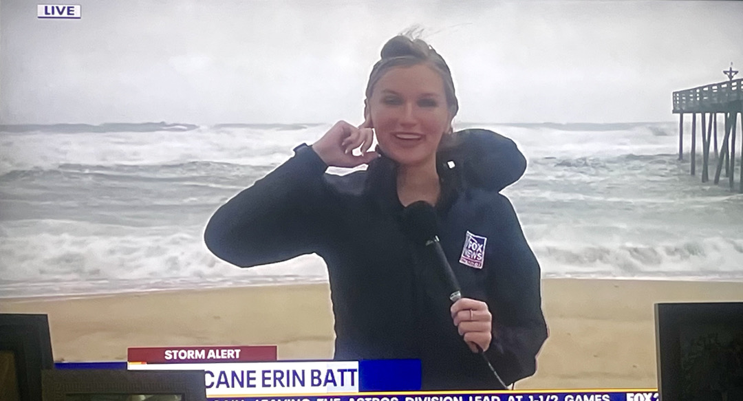
This lady is on the Outer Banks have vacation there many times and this is definitely higher waves than they get, but I have seen waves this high for many storms there so, it's nothing catastrophic …
LittleTexas : Yup they got lucky!
This lady is on the Outer Banks have vacation there many times and this is definitely higher waves than they get, but I have seen waves this high for many storms there so, it's nothing catastrophic …
LittleTexas : I saw that just a few minutes ago too!
teatime : And that is a very good thing. I think all the rain we got this summer made the summer go by faster I think. August is almost over and a few weeks after that I think temperatures may go down to a reasonable temperature.
Kittle StormChaser : Only in the evening please as there is a Kingwood Farmers Market this afternoon from 3 - 7 pm! xoxoxo
« Back to Chat
Views: 343
# Replies: 11