


Space City update - Wed.
Space City update - Wed.

This discussion has been locked.

Joined:
X days ago
# Posts:
X,XXX
Contributor Points:
X


Space City update - Wed. Tropical System Lashing The Texas Coast, But Houston Is Missing Most Of The Action Eric Berger · Wednesday, June 19, 2024 7:03 AM In brief: *A tropical system is bringing heavy rains and lashing winds to the Texas coast this morning, but most of this activity is south of Houston.
*We'll see the potential for widespread showers on Wednesday before lesser rain chances through the weekend.
*Houston's skies will turn partly sunny starting Thursday, with lots of sunshine on Saturday and Sunday. 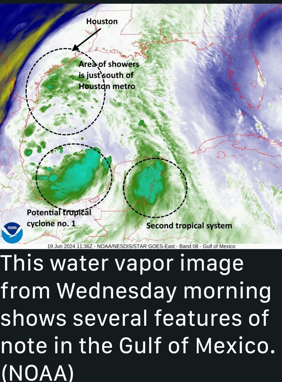 POTENTIAL TROPICAL CYCLONE ONE: *A tropical system in the southern Gulf of Mexico is close to becoming a tropical depression, but it is running out of time as it turns toward the east coast of Mexico.
*It should move inland by Thursday. *Regardless of whether it develops further, the effects for Texas are baked in: elevated winds and seas, with the potential for heavy rainfall along much of the coast-but critically NOT the Houston region. *The light-to-moderate rainfall the city is experiencing this morning is basically the main thrust of the tropical moisture. Yes, this is it. 😉 *In preceding days, we have been careful to balance expectations for this storm by suggesting there was a possibility that the heavy rainfall could go south of Houston, which it ultimately did.
*There is no question our modeling whiffed badly on the risk of flooding in the Houston metro area. (Speaking of modeling, I'll have a short analysis of the performance by AI models tomorrow on this tropical system). *The bottom line is that there is no longer any serious risk of flooding in the greater Houston metro area.
*To the south of the city, including areas such as southern Brazoria County, Bay City, and down into Matagorda Bay, there are notably higher rainfall totals and some risk of additional flooding today.
*These southern areas are also at risk of higher tides and coastal flooding, as well as wind gusts up to 40 mph. WEDNESDAY *The Houston region should see continued scattered light to moderate showers through the morning hours of the Juneteenth holiday.
*It's possible that an additional, broken "band" of showers could develop over Houston this afternoon or evening.
*However, I don't anticipate any of this rain leading to serious flooding issues. For the most part, these should be nuisance showers. *Winds associated with the tropical system in the southern Gulf should peak this afternoon over the Houston metro area, with gusts of 25 to 30 mph possible inland, and up to 40 mph along the coast, including Galveston Island.
*With elevated tides, some coastal flooding of low-lying areas is likely today, and again Thursday morning.
*Skies should be mostly cloudy today, limiting high temperatures to the 80s. THURSDAY *As the tropical system moves into Mexico, it will cease to be a threat in terms of rainfall.
*As a result we are likely to see only scattered showers on Thursday with lesser accumulations.
*Skies will be partly sunny with highs of around 90 degrees. FRIDAY *Skies will be mostly sunny on Friday, with highs near 90 degrees.
*There will be a chance of showers and thunderstorms during the afternoon hours, but it likely is only about 30 percent. 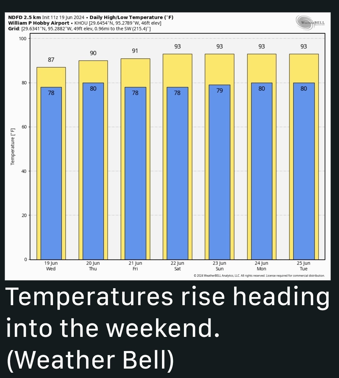 SATURDAY AND SUNDAY *The weekend should bring sunny weather with highs in the low 90s.
*Several readers have asked about a second tropical system, expected to develop in the southern Gulf of Mexico this weekend (see image at the top of this post).
*At this time I don't expect it to have a significant impact on Houston's weather, although it could drive some scattered showers and thunderstorms for coastal areas-that is, along and south of Interstate 10-this weekend. We'll keep an eye on it, but for now it's not something to be too concerned about. NEXT WEEK *Most of next week looks partly to mostly sunny, with highs in the low- to mid-90s.
*We may also see some afternoon, seabreeze-driven showers. All in all, the pattern looks fairly typical for late June as we march toward the heart of summer.


*We'll see the potential for widespread showers on Wednesday before lesser rain chances through the weekend.
*Houston's skies will turn partly sunny starting Thursday, with lots of sunshine on Saturday and Sunday.
*It should move inland by Thursday.
*There is no question our modeling whiffed badly on the risk of flooding in the Houston metro area. (Speaking of modeling, I'll have a short analysis of the performance by AI models tomorrow on this tropical system).
*To the south of the city, including areas such as southern Brazoria County, Bay City, and down into Matagorda Bay, there are notably higher rainfall totals and some risk of additional flooding today.
*These southern areas are also at risk of higher tides and coastal flooding, as well as wind gusts up to 40 mph.
*It's possible that an additional, broken "band" of showers could develop over Houston this afternoon or evening.
*However, I don't anticipate any of this rain leading to serious flooding issues. For the most part, these should be nuisance showers.
*With elevated tides, some coastal flooding of low-lying areas is likely today, and again Thursday morning.
*Skies should be mostly cloudy today, limiting high temperatures to the 80s.
*As a result we are likely to see only scattered showers on Thursday with lesser accumulations.
*Skies will be partly sunny with highs of around 90 degrees.
*There will be a chance of showers and thunderstorms during the afternoon hours, but it likely is only about 30 percent.
*Several readers have asked about a second tropical system, expected to develop in the southern Gulf of Mexico this weekend (see image at the top of this post).
*At this time I don't expect it to have a significant impact on Houston's weather, although it could drive some scattered showers and thunderstorms for coastal areas-that is, along and south of Interstate 10-this weekend.
*We may also see some afternoon, seabreeze-driven showers.
Discussion Insights:
Ask a question about this discussion and an AI bot will try to give an answer.
Ask a question about this discussion and an AI bot will try to give an answer.
Replies:
I want to Thank all of you for blowing this West!!! 🤣 we have a 20% chance of rain -which means it will rain somewhere here in the valley. I hope it's me!

|
Space City update - Wed. Tropical System Lashing The Texas Coast, But Houston Is Missing Most Of The Action Eric Berger · Wednesday, June 19, 2024 7:03 AM In brief: *A tropical system is bringing heavy rains and lashing winds to the Texas coast this morning, but most of this activity is south of Houston. *We'll see the potential for widespread showers on Wednesday before lesser rain chances through the weekend. *Houston's skies will turn partly sunny starting Thursday, with lots of sunshine on Saturday and Sunday. POTENTIAL TROPICAL CYCLONE ONE: *A tropical system in the southern Gulf of Mexico is close to becoming a tropical depression, but it is running out of time as it turns toward the east coast of Mexico. *It should move inland by Thursday. *Regardless of whether it develops further, the effects for Texas are baked in: elevated winds and seas, with the potential for heavy rainfall along much of the coast-but critically NOT the Houston region. *The light-to-moderate rainfall the city is experiencing this morning is basically the main thrust of the tropical moisture. Yes, this is it. 😉 *In preceding days, we have been careful to balance expectations for this storm by suggesting there was a possibility that the heavy rainfall could go south of Houston, which it ultimately did. *There is no question our modeling whiffed badly on the risk of flooding in the Houston metro area. (Speaking of modeling, I'll have a short analysis of the performance by AI models tomorrow on this tropical system). *The bottom line is that there is no longer any serious risk of flooding in the greater Houston metro area. *To the south of the city, including areas such as southern Brazoria County, Bay City, and down into Matagorda Bay, there are notably higher rainfall totals and some risk of additional flooding today. *These southern areas are also at risk of higher tides and coastal flooding, as well as wind gusts up to 40 mph. WEDNESDAY *The Houston region should see continued scattered light to moderate showers through the morning hours of the Juneteenth holiday. *It's possible that an additional, broken "band" of showers could develop over Houston this afternoon or evening. *However, I don't anticipate any of this rain leading to serious flooding issues. For the most part, these should be nuisance showers. *Winds associated with the tropical system in the southern Gulf should peak this afternoon over the Houston metro area, with gusts of 25 to 30 mph possible inland, and up to 40 mph along the coast, including Galveston Island. *With elevated tides, some coastal flooding of low-lying areas is likely today, and again Thursday morning. *Skies should be mostly cloudy today, limiting high temperatures to the 80s. THURSDAY *As the tropical system moves into Mexico, it will cease to be a threat in terms of rainfall. *As a result we are likely to see only scattered showers on Thursday with lesser accumulations. *Skies will be partly sunny with highs of around 90 degrees. FRIDAY *Skies will be mostly sunny on Friday, with highs near 90 degrees. *There will be a chance of showers and thunderstorms during the afternoon hours, but it likely is only about 30 percent. SATURDAY AND SUNDAY *The weekend should bring sunny weather with highs in the low 90s. *Several readers have asked about a second tropical system, expected to develop in the southern Gulf of Mexico this weekend (see image at the top of this post). *At this time I don't expect it to have a significant impact on Houston's weather, although it could drive some scattered showers and thunderstorms for coastal areas-that is, along and south of Interstate 10-this weekend. We'll keep an eye on it, but for now it's not something to be too concerned about. NEXT WEEK *Most of next week looks partly to mostly sunny, with highs in the low- to mid-90s. *We may also see some afternoon, seabreeze-driven showers. All in all, the pattern looks fairly typical for late June as we march toward the heart of summer.
StormChaser : Thank you for all this hard work you do to keep us peeps informed â¤ï¸
StormChaser : can you give me insite as to how this will affect Cancun? I have a friend leaving today to go there for a week.
|
|

Space City update - Wed. Tropical System Lashing The Texas Coast, But Houston Is Missing Most Of The Action Eric Berger · Wednesday, June 19, 2024 7:03 AM In brief: *A tropical system is bringing heavy rains and lashing winds to the Texas coast this morning, but most of this activity is south of Houston. *We'll see the potential for widespread showers on Wednesday before lesser rain chances through the weekend. *Houston's skies will turn partly sunny starting Thursday, with lots of sunshine on Saturday and Sunday. POTENTIAL TROPICAL CYCLONE ONE: *A tropical system in the southern Gulf of Mexico is close to becoming a tropical depression, but it is running out of time as it turns toward the east coast of Mexico. *It should move inland by Thursday. *Regardless of whether it develops further, the effects for Texas are baked in: elevated winds and seas, with the potential for heavy rainfall along much of the coast-but critically NOT the Houston region. *The light-to-moderate rainfall the city is experiencing this morning is basically the main thrust of the tropical moisture. Yes, this is it. 😉 *In preceding days, we have been careful to balance expectations for this storm by suggesting there was a possibility that the heavy rainfall could go south of Houston, which it ultimately did. *There is no question our modeling whiffed badly on the risk of flooding in the Houston metro area. (Speaking of modeling, I'll have a short analysis of the performance by AI models tomorrow on this tropical system). *The bottom line is that there is no longer any serious risk of flooding in the greater Houston metro area. *To the south of the city, including areas such as southern Brazoria County, Bay City, and down into Matagorda Bay, there are notably higher rainfall totals and some risk of additional flooding today. *These southern areas are also at risk of higher tides and coastal flooding, as well as wind gusts up to 40 mph. WEDNESDAY *The Houston region should see continued scattered light to moderate showers through the morning hours of the Juneteenth holiday. *It's possible that an additional, broken "band" of showers could develop over Houston this afternoon or evening. *However, I don't anticipate any of this rain leading to serious flooding issues. For the most part, these should be nuisance showers. *Winds associated with the tropical system in the southern Gulf should peak this afternoon over the Houston metro area, with gusts of 25 to 30 mph possible inland, and up to 40 mph along the coast, including Galveston Island. *With elevated tides, some coastal flooding of low-lying areas is likely today, and again Thursday morning. *Skies should be mostly cloudy today, limiting high temperatures to the 80s. THURSDAY *As the tropical system moves into Mexico, it will cease to be a threat in terms of rainfall. *As a result we are likely to see only scattered showers on Thursday with lesser accumulations. *Skies will be partly sunny with highs of around 90 degrees. FRIDAY *Skies will be mostly sunny on Friday, with highs near 90 degrees. *There will be a chance of showers and thunderstorms during the afternoon hours, but it likely is only about 30 percent. SATURDAY AND SUNDAY *The weekend should bring sunny weather with highs in the low 90s. *Several readers have asked about a second tropical system, expected to develop in the southern Gulf of Mexico this weekend (see image at the top of this post). *At this time I don't expect it to have a significant impact on Houston's weather, although it could drive some scattered showers and thunderstorms for coastal areas-that is, along and south of Interstate 10-this weekend. We'll keep an eye on it, but for now it's not something to be too concerned about. NEXT WEEK *Most of next week looks partly to mostly sunny, with highs in the low- to mid-90s. *We may also see some afternoon, seabreeze-driven showers. All in all, the pattern looks fairly typical for late June as we march toward the heart of summer.
StormChaser : Interesting and thank you. This discussion has been locked.
« Back to ChatViews: 867
# Replies: 7