


Removed By Request.
Removed By Request.

This discussion has been locked.

Joined:
X days ago
# Posts:
X,XXX
Contributor Points:
X


Discussion Insights:
Ask a question about this discussion and an AI bot will try to give an answer.
Ask a question about this discussion and an AI bot will try to give an answer.
Replies:


Space City talks Monday flood risk Ugh. Tomorrow looks really ugly. We'll see 2-4" easily on Monday alone with areas of 5"+. I'll post updates when I can. I'm still dealing with my mother in law so I'm running on fumes. Bear with we guys! ...... From Space City Weather Widespread rain showers likely on Monday: We're issuing a Stage 1 flood alert. January 21, 2024 at 9:13 am by Eric Berger 💧 Summary: *Today will be cloudy and cold, but there should be no issues with outdoor activities.
*That begins to change tonight and especially on Monday morning, as a storm system moves in from the west.
*Expect on-and-off showers, along with heavy rain and potentially some street flooding through the middle of the week. 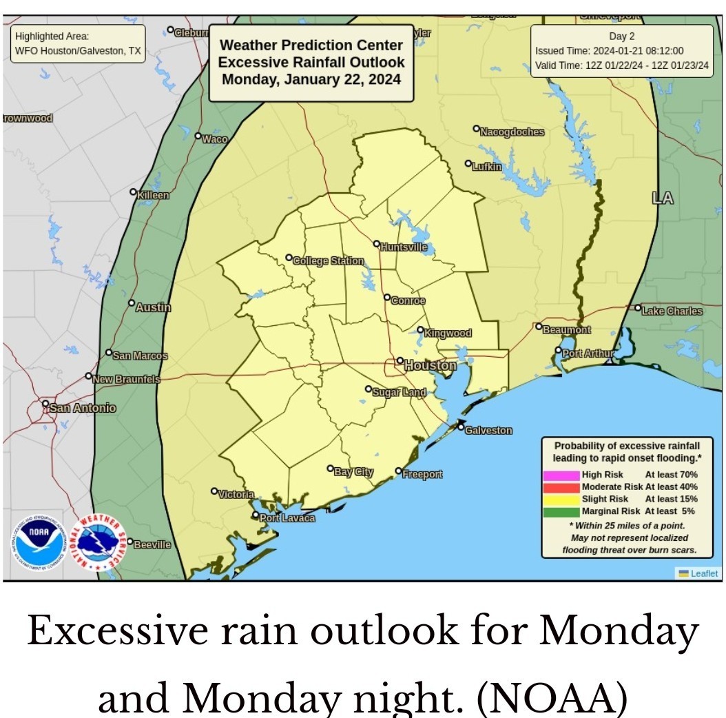 💧 Monday: *This is the day we expect the heaviest and most widespread rain to fall in Houston this week. *An upper-level system will bring favorable conditions for rainfall, and this should spread into the region during the morning hours.
*At this point I expect a mass of showers to congeal west of Houston before sunset, and potentially reach areas such as Katy by around 6 to 8 am.
*Please understand that these times are approximate, and there is the potential for some messy commuting on Monday morning. *We should see widespread showers and thunderstorms for pretty much all of the daytime hours in Houston, and I expect most of us to pick up 2 to 4 inches of rainfall.
*That should be mostly manageable, but we have a few concerns. -One is that some areas may see bullseyes of 5 inches or more.
-The second concern is that the ground is hard from our recent freezes, so instead of soaking up a lot of this rainfall, the water will run off. *So 4 inches of rain in January will back up much quickly than 4 inches in August. 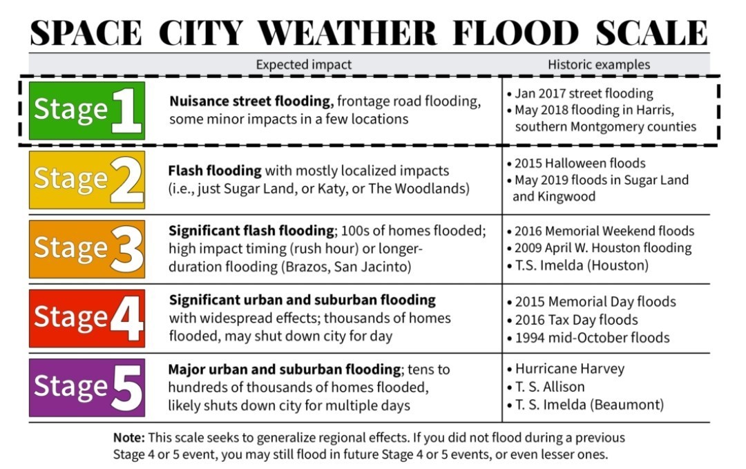 *For this reason we're issuing a Stage 1 flood alert for Monday due primarily to the potential for street flooding.
*It will be a good day to be weather aware before heading out. Certainly not everyone will see impacts, but the potential is there. 💧 Tuesday and Wednesday: *After a possible lull on Monday evening, we are likely to see additional rounds of showers from the period of Monday night through Wednesday.
*It's a little early to have much confidence in the contours of these additional periods of rainfall, but it's my hope that they won't be quite as intense on Monday.
*In terms of temperatures, we're going to be much milder after Sunday.
*Expect highs in the 60s with lows in the upper 50s.
*Conditions turn a bit cooler by the weekend, probably. *All told, I expect the Houston region to pick up between 4 and 8 inches this week. Matt and I will be monitoring the situation closely today, and the rest of the week to ensure that you remain on top of conditions. We will update the site, and our flood scale predictions, as warranted.
*That begins to change tonight and especially on Monday morning, as a storm system moves in from the west.
*Expect on-and-off showers, along with heavy rain and potentially some street flooding through the middle of the week.
*At this point I expect a mass of showers to congeal west of Houston before sunset, and potentially reach areas such as Katy by around 6 to 8 am.
*Please understand that these times are approximate, and there is the potential for some messy commuting on Monday morning.
*That should be mostly manageable, but we have a few concerns.
-The second concern is that the ground is hard from our recent freezes, so instead of soaking up a lot of this rainfall, the water will run off.
*It will be a good day to be weather aware before heading out. Certainly not everyone will see impacts, but the potential is there.
*It's a little early to have much confidence in the contours of these additional periods of rainfall, but it's my hope that they won't be quite as intense on Monday.
*In terms of temperatures, we're going to be much milder after Sunday.
*Expect highs in the 60s with lows in the upper 50s.
*Conditions turn a bit cooler by the weekend, probably.
 Ruger5 tipped
  StormChaser 100 credits for a post in this forum discussion.

|
Space City talks Monday flood risk Ugh. Tomorrow looks really ugly. We'll see 2-4" easily on Monday alone with areas of 5"+. I'll post updates when I can. I'm still dealing with my mother in law so I'm running on fumes. Bear with we guys! ...... From Space City Weather Widespread rain showers likely on Monday: We're issuing a Stage 1 flood alert. January 21, 2024 at 9:13 am by Eric Berger 💧 Summary: *Today will be cloudy and cold, but there should be no issues with outdoor activities. *That begins to change tonight and especially on Monday morning, as a storm system moves in from the west. *Expect on-and-off showers, along with heavy rain and potentially some street flooding through the middle of the week. 💧 Monday: *This is the day we expect the heaviest and most widespread rain to fall in Houston this week. *An upper-level system will bring favorable conditions for rainfall, and this should spread into the region during the morning hours. *At this point I expect a mass of showers to congeal west of Houston before sunset, and potentially reach areas such as Katy by around 6 to 8 am. *Please understand that these times are approximate, and there is the potential for some messy commuting on Monday morning. *We should see widespread showers and thunderstorms for pretty much all of the daytime hours in Houston, and I expect most of us to pick up 2 to 4 inches of rainfall. *That should be mostly manageable, but we have a few concerns. -One is that some areas may see bullseyes of 5 inches or more. -The second concern is that the ground is hard from our recent freezes, so instead of soaking up a lot of this rainfall, the water will run off. *So 4 inches of rain in January will back up much quickly than 4 inches in August. *For this reason we're issuing a Stage 1 flood alert for Monday due primarily to the potential for street flooding. *It will be a good day to be weather aware before heading out. Certainly not everyone will see impacts, but the potential is there. 💧 Tuesday and Wednesday: *After a possible lull on Monday evening, we are likely to see additional rounds of showers from the period of Monday night through Wednesday. *It's a little early to have much confidence in the contours of these additional periods of rainfall, but it's my hope that they won't be quite as intense on Monday. *In terms of temperatures, we're going to be much milder after Sunday. *Expect highs in the 60s with lows in the upper 50s. *Conditions turn a bit cooler by the weekend, probably. *All told, I expect the Houston region to pick up between 4 and 8 inches this week. Matt and I will be monitoring the situation closely today, and the rest of the week to ensure that you remain on top of conditions. We will update the site, and our flood scale predictions, as warranted.
StormChaser : Thanks for posting and wishing you the best with your MIL and all the things that you juggle!
|
|
StormChaser: Thanks for the heads up on the weather. Prayers for you and the situation with your MIL.
StormChaser : It looks like there will be some big rains, and the fear is the flooding and ponding of our roads, and people trying to drive in it
 I happen to have off the first 3 days this week, and going to stay in, and get things done. My list has been growing, since Christmas!

Space City Weather is a blessing to Houston Area!
My DD has appointment in med center. Hope the worst holds off till after noon 😞
StormChaser : I hope drivers remember to Not drive through flooded streets, underpasses, etc!
 LittleTexas : Turn around don't drown!
This discussion has been locked.
« Back to ChatViews: 1,422
# Replies: 13