


Severe weather forecast
Severe weather forecast


Joined:
X days ago
# Posts:
X,XXX
Contributor Points:
X


Severe weather forecast Tonight's storms:
❤️Possibility of damaging winds (with the main line of storms as they blow through) along with small hail.
❤️A few brief tornadoes are also possible but I want to emphasize that right now this does not have the classic setup for severe weather. Timeline:
❤️The Woodlands to Katy around 5 to 7 pm
❤️Central Houston shortly thereafter --
❤️Off the coast by 8 to 10 pm. Here's what to expect from our 'sweetheart' storms this evening in Houston. Eric Berger · Saturday, February 14, 2026 11:35 AM In brief: Happy Valentine's Day, everyone! As we've been discussing for several days now, Houston will face the threat of storms this evening, and we just wanted to jump into your timeline today with an update on what to expect, and when. Saturday afternoon - *We've seen some scattered, mostly light showers this morning, and those will persist on and off through at least the early afternoon hours.
*Generally we will see highs in the 70s with very humid air. Skies will remain mostly cloudy.
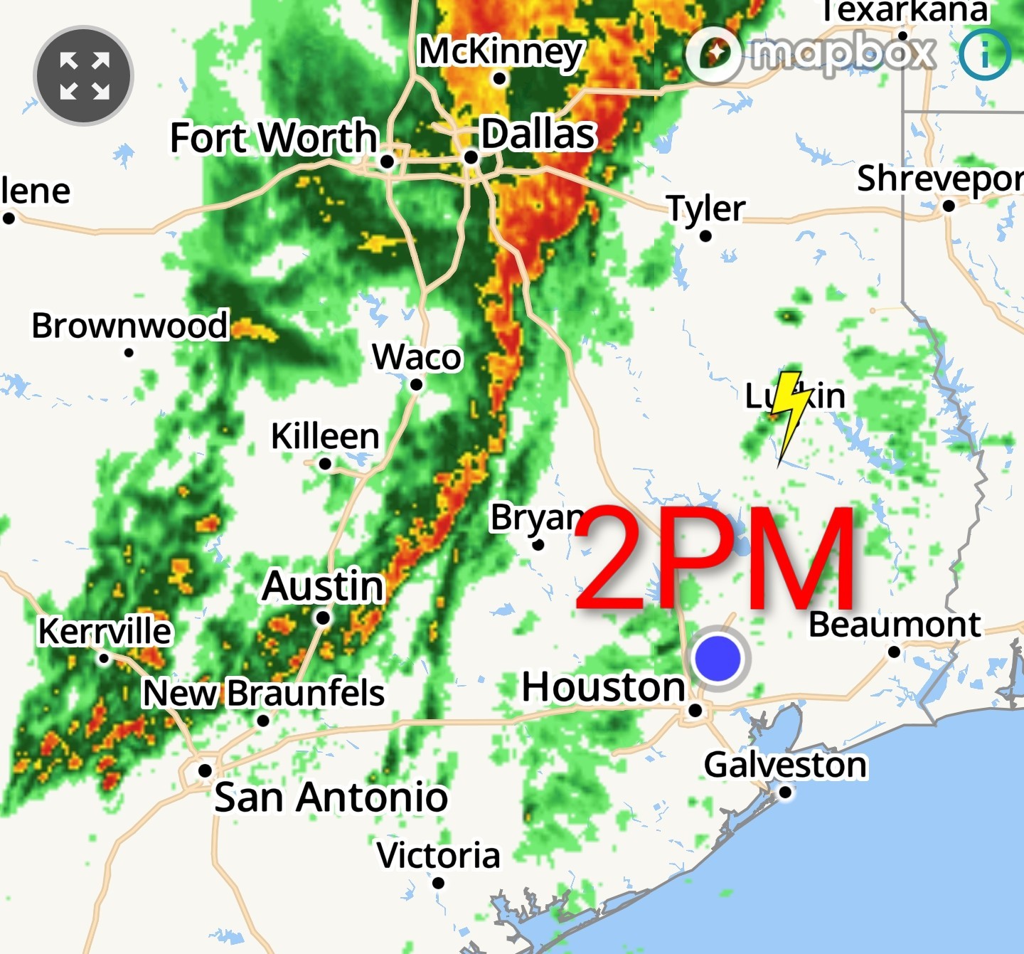
*By late this afternoon a line of showers and thunderstorms will start to approach the Houston region from the northwest, likely reaching College Station between 4 pm and 6 pm CT. Saturday evening - *I realize that a lot of people have plans this evening, and that's great, but we are going to ask you to please be weather aware.
*Our latest high-resolution modeling suggests this line of storms will strengthen as it nears the coast.
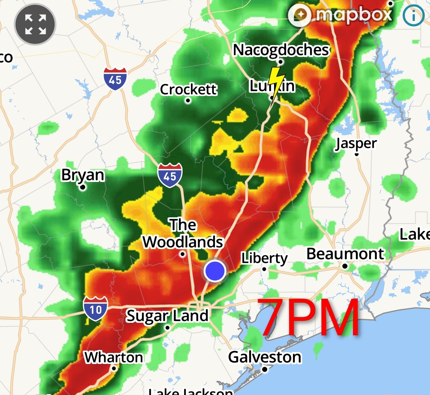
*I expect the storms to reach a line from The Woodlands to Katy around 5 to 7 pm, central Houston shortly thereafter, and move off the coast by 8 to 10 pm.
*The line will be moving through progressively, but because the showers may be intense most locations probably will pick up on the order of 1 inch of rain. 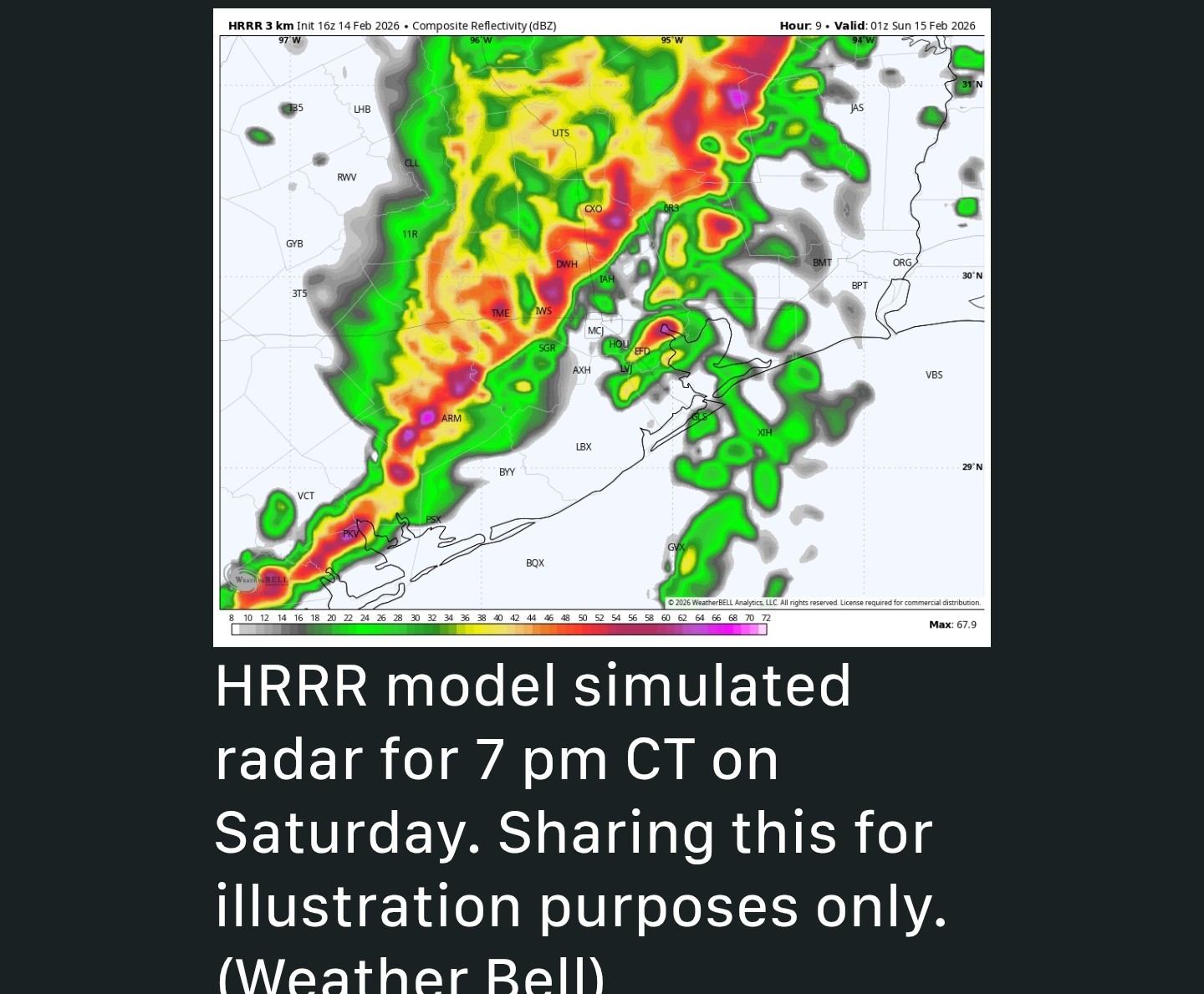 How about other severe threats? *NOAA has raised the threat of severe weather for the Houston region to "slight risk."
*Effectively this means there will be the possibility of damaging winds (with the main line of storms as they blow through) along with small hail.
*A few brief tornadoes are also possible, but I want to emphasize that right now this does not have the classic setup for severe weather. *Anyway, the weather at your location in southeast Houston will turn gnarly for about an hour this evening, give or take.
*If you take cover as the system blows through, you can just as easily move about safely once it has passed.
*Conditions will calm down quickly this evening after the storms, with temperatures of about 60 degrees, falling to the upper 50s by Sunday morning. 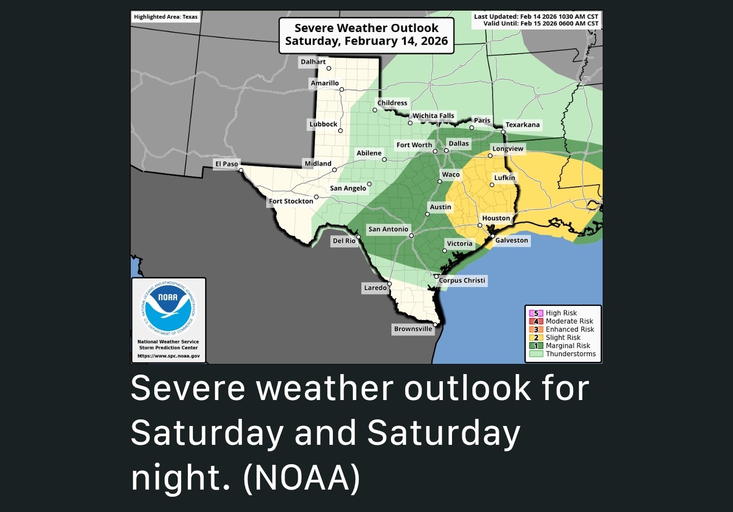 Sunday - *By sunrise on Sunday we should see some stronger northerly winds, with gusts up to about 30 mph or so as drier air moves in.
*These winds should start to back off some by Sunday afternoon.
*Expect clearing skies, with a high of around 70 degrees.
*Lows on Sunday night will drop into the mid-50s in Houston, with cooler conditions for outlying


teatime, peppermintstick and Kittle + 6 more reacted ❤️Possibility of damaging winds (with the main line of storms as they blow through) along with small hail.
❤️A few brief tornadoes are also possible but I want to emphasize that right now this does not have the classic setup for severe weather.
❤️The Woodlands to Katy around 5 to 7 pm
❤️Central Houston shortly thereafter --
❤️Off the coast by 8 to 10 pm.
*Generally we will see highs in the 70s with very humid air. Skies will remain mostly cloudy.
*By late this afternoon a line of showers and thunderstorms will start to approach the Houston region from the northwest, likely reaching College Station between 4 pm and 6 pm CT.
*Our latest high-resolution modeling suggests this line of storms will strengthen as it nears the coast.
*I expect the storms to reach a line from The Woodlands to Katy around 5 to 7 pm, central Houston shortly thereafter, and move off the coast by 8 to 10 pm.
*The line will be moving through progressively, but because the showers may be intense most locations probably will pick up on the order of 1 inch of rain.
*Effectively this means there will be the possibility of damaging winds (with the main line of storms as they blow through) along with small hail.
*A few brief tornadoes are also possible, but I want to emphasize that right now this does not have the classic setup for severe weather.
*If you take cover as the system blows through, you can just as easily move about safely once it has passed.
*Conditions will calm down quickly this evening after the storms, with temperatures of about 60 degrees, falling to the upper 50s by Sunday morning.
*These winds should start to back off some by Sunday afternoon.
*Expect clearing skies, with a high of around 70 degrees.
*Lows on Sunday night will drop into the mid-50s in Houston, with cooler conditions for outlying
Replies:

|

Current 2pm: Future 7pm:
StormChaser : Thinking I may make a cup off coffee for the morning and put it in the frig in case......shhhh....you know what happens! LOL~!
StormChaser : Nice overcast day to get out and enjoy a relaxing Valentine's Day lunch in Town Centre!
|
|
WATCHING a lower end #tornado threat this evening across southeastern Texas into central/southern Louisiana along and ahead of a squall line during a 5-10 pm window. This could include the Houston to Lake Charles areas along and north of the I-10 corridor. Despite a favorable trough shape, this setup looks a little messy, but a strong low-level jet axis will faster a #tornado threat along the squall line and with any renegade storms that can organize along prefrontal confluence bands. 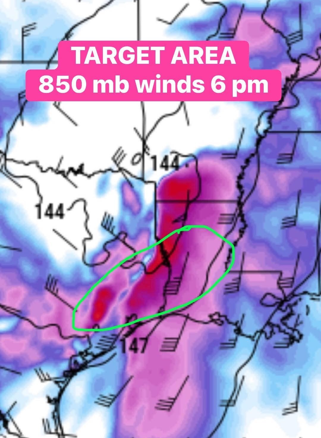
Kittle, SteveT and teatime reacted
|
|
WATCHING a lower end #tornado threat this evening across southeastern Texas into central/southern Louisiana along and ahead of a squall line during a 5-10 pm window. This could include the Houston to Lake Charles areas along and north of the I-10 corridor. Despite a favorable trough shape, this setup looks a little messy, but a strong low-level jet axis will faster a #tornado threat along the squall line and with any renegade storms that can organize along prefrontal confluence bands.
StormChaser : 850 mb winds?? « Back to Chat
Views: 552
# Replies: 9