


SCW Isaias update
SCW Isaias update


Joined:
X days ago
# Posts:
X,XXX
Contributor Points:
X


SCW Isaias update Isaias will give SE Texas some cooler, drier air. From Space City Weather: With Isaias bound for northern Gulf coast Texas to see calm, if warm, weather. Eric Berger · Wednesday, October 7, 2026 6:49 AM 👉IN BRIEF: *Tropical Storm Isaias has formed in the southern Gulf, and it has a really good chance to become the season's first hurricane.
*It is bound for the northern Gulf coast. (NOLA - Panama City)
*This should usher in a few days of drier air into Houston this weekend. 👉A GULF HURRICANE? *In the modern record, an era dating back to World War II when there has been aircraft reconnaissance and later continuous satellite coverage, there has never been an Atlantic season without a hurricane.
*Prior to this there have been two years, 1907 and 1914, in which no hurricanes were recorded.
*However, that does not definitively mean there were no hurricanes.
*Before aircraft flew across the Atlantic, our records almost certainly missed hurricanes over the open ocean. 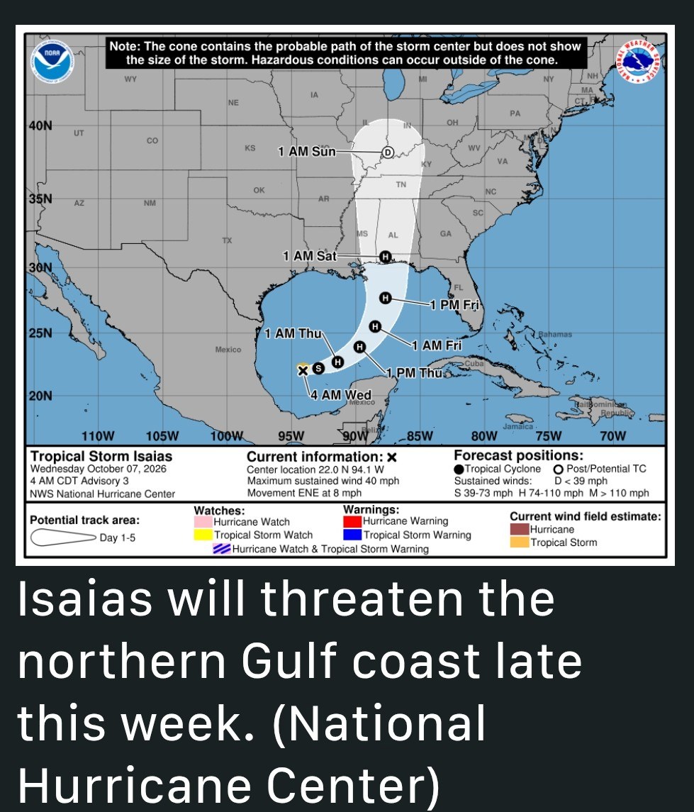 *So far this year, with El Niño reaching historic strength, the Atlantic has produced several tropical storms but no systems that have reached hurricane strength.
*With the formation of Isaias in the southern Gulf that is likely to change.
*There is a high likelihood that Isaias will become a hurricane, and possibly a major hurricane over the warm Gulf waters before tracking north toward a landfall somewhere between southeastern Louisiana and the Florida Panhandle late Friday or early Saturday.
*Be sure to check The Eyewall for full and ongoing coverage of Isaias. *Along the upper Texas coast we may see tides running a foot or two higher, and some rough seas offshore.
*Mostly we should see some modestly drier on Thursday, Friday, and Saturday. 👉WEDNESDAY and THURSDAY - *Today and Thursday will be warm (hot?) and sunny days, with high temperatures in the lower 90s for most of the region, away from the coast.
*Rain chances are essentially zero.
*Nights will be warm, with lows generally in the low to mid-70s.
*On Thursday afternoon we should start to see modestly stronger winds from the northeast (on the backside of Isaias), and this will bring us some moderately drier air for a few days. 👉FRIDAY and SATURDAY - *These will be mostly sunny days with a slightly cooler northeasterly flow.
*Highs will be in the upper 80s to lower 90s.
*For areas along and south of I-10 there will be a slight chance of showers on Friday afternoon, but probably only in the 10 to 20 percent range.
*Nights will be pleasant, with lows around 70 degrees in Houston, and in the 60s for outlying areas. 👉REST OF NEXT WEEK - *With the return of the onshore flow we could see some decent rain chances as early as Monday or Tuesday of next week, and I think we'll see a healthy 30 percent chance (or so) on a daily basis on most days.
*Highs will continue in the vicinity of the upper 80s to lower 90s.
*I'm still looking at the possibility of a stronger fall front later next week, but this is no sure thing so don't bring out your box of sweaters just yet.

BELIEVE and malpalface reacted *It is bound for the northern Gulf coast. (NOLA - Panama City)
*This should usher in a few days of drier air into Houston this weekend.
*Prior to this there have been two years, 1907 and 1914, in which no hurricanes were recorded.
*However, that does not definitively mean there were no hurricanes.
*Before aircraft flew across the Atlantic, our records almost certainly missed hurricanes over the open ocean.
*With the formation of Isaias in the southern Gulf that is likely to change.
*There is a high likelihood that Isaias will become a hurricane, and possibly a major hurricane over the warm Gulf waters before tracking north toward a landfall somewhere between southeastern Louisiana and the Florida Panhandle late Friday or early Saturday.
*Be sure to check The Eyewall for full and ongoing coverage of Isaias.
*Mostly we should see some modestly drier on Thursday, Friday, and Saturday.
*Rain chances are essentially zero.
*Nights will be warm, with lows generally in the low to mid-70s.
*On Thursday afternoon we should start to see modestly stronger winds from the northeast (on the backside of Isaias), and this will bring us some moderately drier air for a few days.
*Highs will be in the upper 80s to lower 90s.
*For areas along and south of I-10 there will be a slight chance of showers on Friday afternoon, but probably only in the 10 to 20 percent range.
*Nights will be pleasant, with lows around 70 degrees in Houston, and in the 60s for outlying areas.
*Highs will continue in the vicinity of the upper 80s to lower 90s.
*I'm still looking at the possibility of a stronger fall front later next week, but this is no sure thing so don't bring out your box of sweaters just yet.
Replies:

Thanks! Cooler, drier air would be nice. Mike Iscovitz was just saying it could strengthen?
« Back to Chat
Views: 111
# Replies: 1