


Jeff Lindner update - 6am SAT
Jeff Lindner update - 6am SAT

This discussion has been locked.

Joined:
X days ago
# Posts:
X,XXX
Contributor Points:
X


Jeff Lindner update - 6am SAT Really informative post from Jeff Lindner. I miss this dude and I'm so glad he still posts. He is a Meteorologist so he knows his stuff. â— BUT FIRST - let's ALL take a deep breath. â¤ï¸ The forecast is still the same as last night - no better - but no worse. 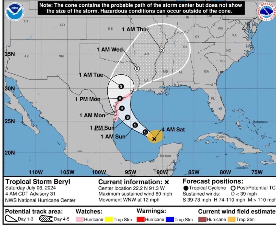 -Unfortunately, a lot of uncertainty still remains.
-He is suggesting you prepare TODAY for a CAT 2 Landfall starting late tomorrow night (Sunday), into mid day Monday, near Port O'Connor.
-This path could deviate NORTH or SOUTH at the last moment which could drastically change the effects we have here in Houston. ◠This is why they suggest preparing TODAY for a worst case scenario. 🌀HURRICANE BERYL
🌀TROPICAL STORM
🌀60MPH WINDS
🌀75MPH GUSTS
🌀WNW AT 12MPH 7/6/24 6AM SATURDAY
*Preparations to protect life and property should be underway in the Hurricane Watch area. *Hurricane Watch remains in effect from San Luis Pass to the mouth of the Rio Grande River
*Storm Surge Watch remains in effect from High Island to the mouth of the Rio Grande River.
DISCUSSION: *The low level circulation of Beryl has become largely exposed this morning with only a few pockets of deep convection to the north of the center.
*Dry air and 20kts of southerly wind shear along with the interaction of the Yucatan have resulted in the overall weakening of the system.
*The pressure has risen to 1001mb and winds are being held at 60mph per reports from overnight recon aircraft.
*Beryl is moving WNW at 12mph located 545 miles SE of Corpus Christi, TX.
*Tropical storm force winds extend outward 115 miles from the center.
TRACK: â— There have been no significant changes to the track forecast overnight after large northward adjustments on Friday.
â— The ECWMF is along the eastern edge of the guidance cluster (with a landfall around Sargent) while the GFS and UKMET are near the western edge (with a landfall around Rockport).
â— The consensus track and NHC forecast are nearly identical at 400am with a landfall near Port O Connor TX Monday midday.
*There remains some track uncertainty with the various ensemble members showing more spread that the deterministic guidance so additional adjustments could be made with the track today.
â— Given the angle of approach to the TX coast - and the fact that Beryl will be gradually turning to the right on approach - continues to result in the potential for large differences in the actual landfall location with only small deviations in the actual forecast track. 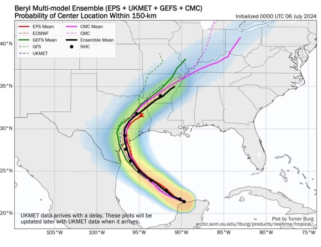
*While there has been much focus on where the center will ultimately make landfall…it should be understood that impacts will occur well away from the landfall location including: -Heavy rainfall
-Inland flooding
-Strong winds -TS winds extend 115 miles outward from the center.
-Coastal storm surge flooding. 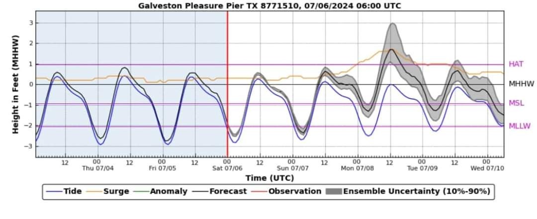 INTENSITY: *Given the state of Beryl this morning, little intensification is expected today. (That will change)
*Additionally, upper level conditions and dry air lurking to the south do not support an overly favorable environment for strengthening.
â— The upper level low over the southwest Gulf of Mexico that is producing the 20kts of southerly shear will move SW away from Beryl over the next 24 hours and THIS will begin to create more favorable conditions as Beryl moves over increasingly warmer sea surface temperatures in the mid to upper 80's.
*Global forecast guidance and higher resolution guidance shows Beryl starting a steady and then potentially quicker intensification (Remember I mentioned rapid intensification yesterday?) within the last 18-24 hours on approach to the Texas coast on Sunday.
â—NHC is above much of the intensity guidance with the landfall of a CAT 2 - 90mph hurricane and there remains some uncertainty. (IKE was a CAT 1) â— Preparations should be made for the landfall of a category 2 hurricane.
IMPACTS:
*Tropical storm and eventually hurricane conditions will build northward toward the Matagorda Bay area Sunday evening into Monday morning with sustained tropical storm and hurricane conditions across all of Matagorda Bay Monday.
*Sustained hurricane conditions will spread inland over Matagorda, Jackson, and Wharton Counties based on the latest track guidance with TS force winds into portions of Brazoria, southern Fort Bend, Colorado, and Austin Counties.
*The most likely arrival time of TS force winds along the coast will be around 800pm Sunday evening.
â— Any shift in the track or slight expansion of the wind field would bring higher storm force winds to Harris, Galveston, and potentially Chambers Counties.
*Widespread power outages are likely around Matagorda Bay with isolated to scattered power outages possible across Brazoria, Galveston, Fort Bend, and Harris Counties. 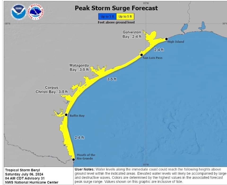
*These values are similar to TS Alberto from San Luis Pass to High Island and 1-2 ft higher than Alberto west of San Luis Pass.
*Voluntary evacuations have been recommended for low lying coastal areas of Calhoun and Jackson Counties and for the Matagorda, Sargent, and waterfront of the City of Palacios in Matagorda County
*Heavy to excessive rainfall will move inland along and to the right of the track of Beryl.
â—Widespread rainfall amounts of 5-10 inches will be likely along the track of Beryl with isolated amounts up to 15 inches possible.
*Significant rainfall will spread inland along the track of Beryl generating widespread run-off into area rivers…especially the Brazos, San Jacinto, San Bernard, and Trinity basins.
*Given the tropical nature of the air mass, high rainfall rates will be possible leading to urban flash flooding in any sustained banding on the eastern flank (right) of the circulation.
*Rainfall could approach levels that would result in bayou, creek, and river flooding. WPC has upgraded portions of the area into a moderate risk for flash flooding for Monday mainly along and west of I-45. 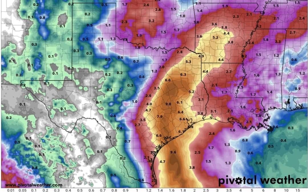
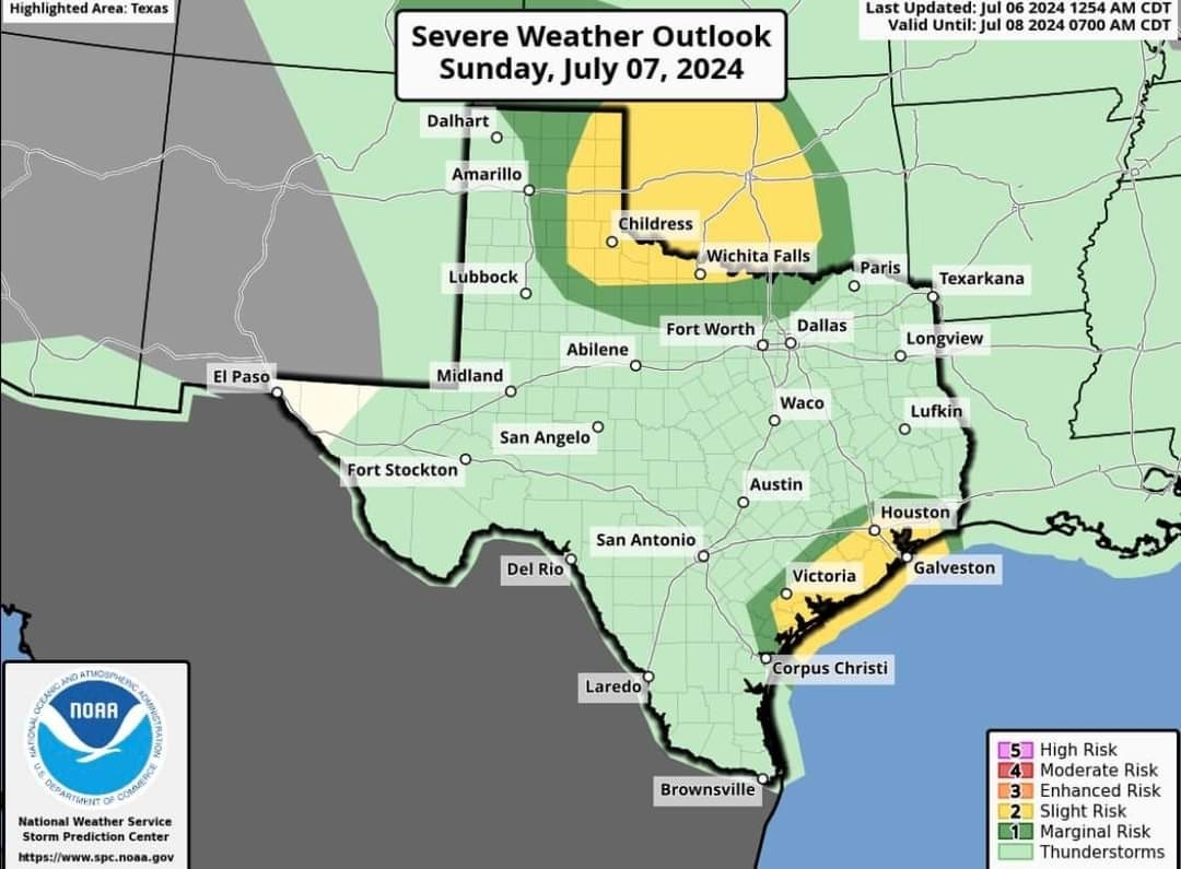 *There will be an increasing risk for tornadoes late Sunday into Tuesday across the upper TX coast and this area will be in the favored right front quadrant of the circulation.
*SPC has places the coastal areas in a slight risk for tornadoes late Sunday and much of the area along and east of I-45 on Monday.


-He is suggesting you prepare TODAY for a CAT 2 Landfall starting late tomorrow night (Sunday), into mid day Monday, near Port O'Connor.
-This path could deviate NORTH or SOUTH at the last moment which could drastically change the effects we have here in Houston.
********************
🌀TROPICAL STORM
🌀60MPH WINDS
🌀75MPH GUSTS
🌀WNW AT 12MPH
*Preparations to protect life and property should be underway in the Hurricane Watch area.
*Storm Surge Watch remains in effect from High Island to the mouth of the Rio Grande River.
DISCUSSION:
*Dry air and 20kts of southerly wind shear along with the interaction of the Yucatan have resulted in the overall weakening of the system.
*The pressure has risen to 1001mb and winds are being held at 60mph per reports from overnight recon aircraft.
*Beryl is moving WNW at 12mph located 545 miles SE of Corpus Christi, TX.
*Tropical storm force winds extend outward 115 miles from the center.
TRACK:
â— The ECWMF is along the eastern edge of the guidance cluster (with a landfall around Sargent) while the GFS and UKMET are near the western edge (with a landfall around Rockport).
â— The consensus track and NHC forecast are nearly identical at 400am with a landfall near Port O Connor TX Monday midday.
*There remains some track uncertainty with the various ensemble members showing more spread that the deterministic guidance so additional adjustments could be made with the track today.
â— Given the angle of approach to the TX coast - and the fact that Beryl will be gradually turning to the right on approach - continues to result in the potential for large differences in the actual landfall location with only small deviations in the actual forecast track.
*While there has been much focus on where the center will ultimately make landfall…it should be understood that impacts will occur well away from the landfall location including:
-Inland flooding
-Strong winds -TS winds extend 115 miles outward from the center.
-Coastal storm surge flooding.
*Additionally, upper level conditions and dry air lurking to the south do not support an overly favorable environment for strengthening.
â— The upper level low over the southwest Gulf of Mexico that is producing the 20kts of southerly shear will move SW away from Beryl over the next 24 hours and THIS will begin to create more favorable conditions as Beryl moves over increasingly warmer sea surface temperatures in the mid to upper 80's.
*Global forecast guidance and higher resolution guidance shows Beryl starting a steady and then potentially quicker intensification (Remember I mentioned rapid intensification yesterday?) within the last 18-24 hours on approach to the Texas coast on Sunday.
â—NHC is above much of the intensity guidance with the landfall of a CAT 2 - 90mph hurricane and there remains some uncertainty. (IKE was a CAT 1)
IMPACTS:
*Tropical storm and eventually hurricane conditions will build northward toward the Matagorda Bay area Sunday evening into Monday morning with sustained tropical storm and hurricane conditions across all of Matagorda Bay Monday.
*Sustained hurricane conditions will spread inland over Matagorda, Jackson, and Wharton Counties based on the latest track guidance with TS force winds into portions of Brazoria, southern Fort Bend, Colorado, and Austin Counties.
*The most likely arrival time of TS force winds along the coast will be around 800pm Sunday evening.
â— Any shift in the track or slight expansion of the wind field would bring higher storm force winds to Harris, Galveston, and potentially Chambers Counties.
*Widespread power outages are likely around Matagorda Bay with isolated to scattered power outages possible across Brazoria, Galveston, Fort Bend, and Harris Counties.
*These values are similar to TS Alberto from San Luis Pass to High Island and 1-2 ft higher than Alberto west of San Luis Pass.
*Voluntary evacuations have been recommended for low lying coastal areas of Calhoun and Jackson Counties and for the Matagorda, Sargent, and waterfront of the City of Palacios in Matagorda County
*Heavy to excessive rainfall will move inland along and to the right of the track of Beryl.
â—Widespread rainfall amounts of 5-10 inches will be likely along the track of Beryl with isolated amounts up to 15 inches possible.
*Significant rainfall will spread inland along the track of Beryl generating widespread run-off into area rivers…especially the Brazos, San Jacinto, San Bernard, and Trinity basins.
*Given the tropical nature of the air mass, high rainfall rates will be possible leading to urban flash flooding in any sustained banding on the eastern flank (right) of the circulation.
*Rainfall could approach levels that would result in bayou, creek, and river flooding. WPC has upgraded portions of the area into a moderate risk for flash flooding for Monday mainly along and west of I-45.
*SPC has places the coastal areas in a slight risk for tornadoes late Sunday and much of the area along and east of I-45 on Monday.
Discussion Summary:
Jeff Lindner Hurricane Beryl Update: Prepare for CAT 2 Landfall near Port O'Connor, Uncertainties Remain
Jeff Lindner Hurricane Beryl Update: Prepare for CAT 2 Landfall near Port O'Connor, Uncertainties Remain
Discussion Insights:
Ask a question about this discussion and an AI bot will try to give an answer.
Ask a question about this discussion and an AI bot will try to give an answer.
Replies:

|
I'll update as needed today guys. 💚 I've had a lot of people ask me - "What are YOU doing?" The answer is: *I gassed up all 3 vehicles.
*I did the grocery shopping 3 days ago when I saw the track potential and we bought more than usual - including bottled water and batteries (but only because we were completely out)
*Today I am taking care of the yard and bringing everything in the garage or securing it.
*We changed the oil in the small generator we have and made sure it's in good working order.
*I'm charging my external batteries & rechargeable led lanterns. *IF this thing really goes nuts tomorrow:
-We're prepared to board up the big windows - takes about 2 hours. I would only do this if it's a CAT 3 OR ABOVE.
-I have 2 interior closets that I would empty just in case. Again, those last 2 are only if it really gets ugly. Unfortunately - we won't have much time if it does. So, with this all being so up in the air so close up landfall, they suggest you prepare now in case because a surprise CAT 3 would really suck if you haven't prepared at least some basics. Remember -Ike was bad & Ike was a CAT 1. They are comparing this more to Alicia which was a CAT 3 at landfall
*I did the grocery shopping 3 days ago when I saw the track potential and we bought more than usual - including bottled water and batteries (but only because we were completely out)
*Today I am taking care of the yard and bringing everything in the garage or securing it.
*We changed the oil in the small generator we have and made sure it's in good working order.
*I'm charging my external batteries & rechargeable led lanterns.
-We're prepared to board up the big windows - takes about 2 hours. I would only do this if it's a CAT 3 OR ABOVE.
-I have 2 interior closets that I would empty just in case.

At least it's a smaller hurricane and not a bigger one like Katrina or Ike where the effects would be widespread and it didn't matter where you were.
Thanks for all your postings- Keepin Kingwood safe!
Thanks for all your postings- Keepin Kingwood safe!
|
|
At least it's a smaller hurricane and not a bigger one like Katrina or Ike where the effects would be widespread and it didn't matter where you were. Thanks for all your postings- Keepin Kingwood safe!
Labslady : Yes it is a compact storm and that is a good thing.
|
|
StormChaser : Thank you for the report. Sure hope this storm doesn't sit out there and get stronger.
Hoping..and still hoping....all of the naysayers would be right on this one...but this one has had me concerned since it was in the Caribbean.
|
|
I need to clarify lol. My days are running together bc my husband is on vacation. TOMORROW will give us a good idea of where this thing is going and what it's going to do. I keep thinking today is Sunday 🤦â€â™€ï¸ First impacts would begin tomorrow (Sunday) night Landfall would be mid day Monday, depending on where. Anywhere from Corpus to Beaumont should be paying attention.
This discussion has been locked.
« Back to ChatViews: 937
# Replies: 6