


Forecast update
Forecast update


Joined:
X days ago
# Posts:
X,XXX
Contributor Points:
X


Forecast update Unfortunately, models have backed way off on our rain totals for the next 4 days. *TODAY: Warm with a 20-30% chance of light, scattered showers.
*FRIDAY: Warm with a 50% chance of rain; totals expected to stay under one half inch. 🙄
*FRIDAY NIGHT: Showers overnight.
*WEEKEND: See detailed post below. 🦃 TURKEY DAY: Thanksgiving looks beautiful with sunny skies and highs in the 60s. .......... From Space City Weather: THURSDAY (TODAY) - *The city tied its record high of 85 degrees on Wednesday (previously set in 1985).
*Today's record high is 84 degrees, and we probably will tie this record today as well, if not beat it. *Conditions will remain very humid, with partly to mostly cloudy skies.
*There will be a slight chance of rain today and tonight, perhaps 10 or 20 percent. Any showers that develop will pass quickly.
*This afternoon will be windier, with gusts as high as 20 mph, from the south.
*Lows will only drop to around 70 degrees. FRIDAY (TOMORROW) - *This will be another warm day, with temperatures in the mid-80s.
*A front will sag toward the area, and this will increase shower and (possibly) thunderstorm chances.
*Higher resolution models have really backed off on the potential for precipitation. I still think there's a 50 percent chance of rain on Friday and Friday night, but the overall rain totals will be on the lower side, with most areas probably picking up less than one-half inch through Saturday.
*Lows Friday night will remain warm, likely in the upper 60s. 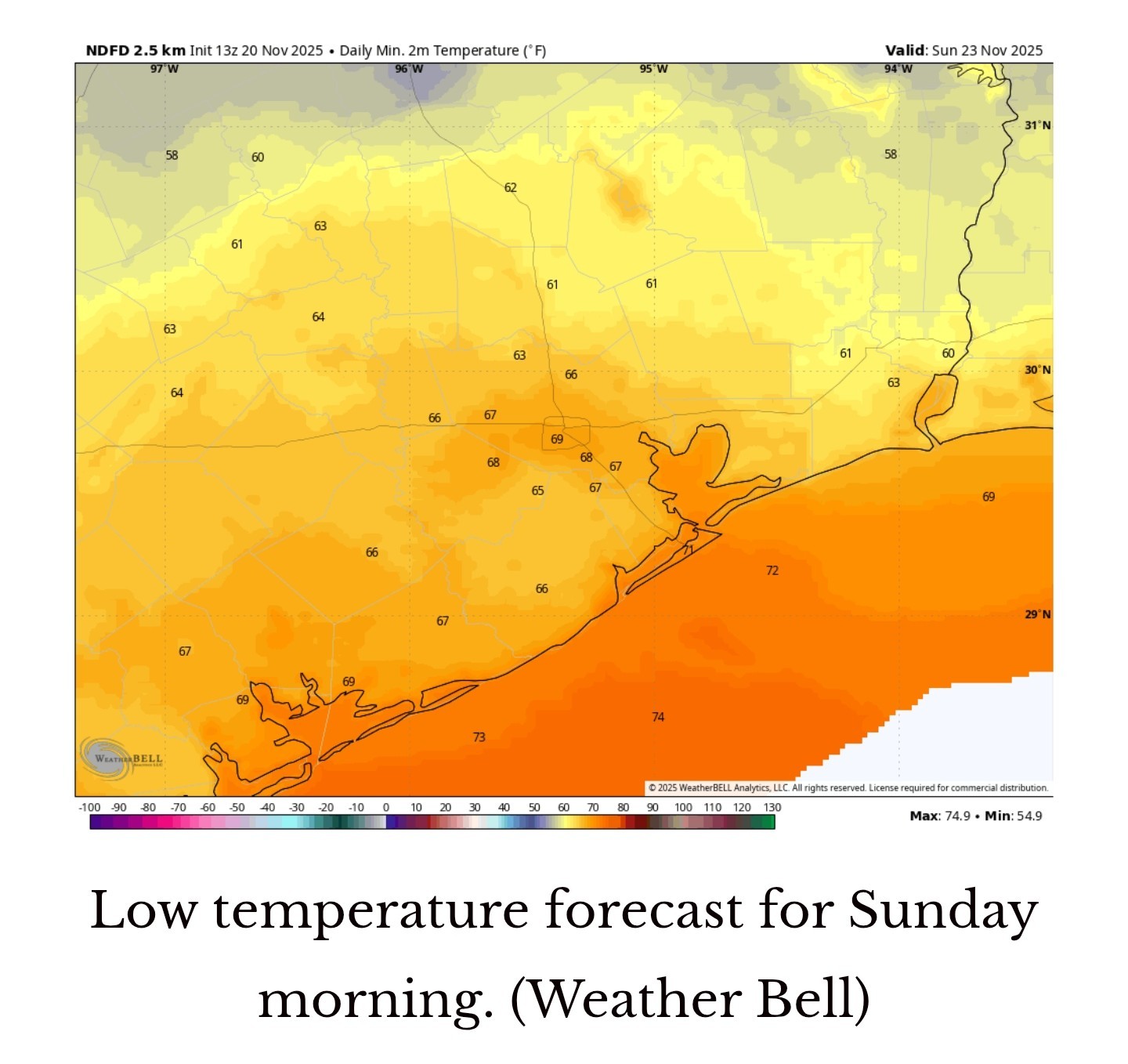 SATURDAY AND SUNDAY - The weak front is going to move into Houston and stall out. This will have some interesting and unpredictable effects on our weather this weekend. *It's likely that some areas inland of Interstate 10 will see some drier and briefly cooler air, with perhaps the maximum extent of this nose of drier air occurring on Saturday night into Sunday morning.
*The presence of the stalled front will also mean that the region continues to see a decent chance of showers on Saturday, and possibly Sunday as well.
*These will not be wall to wall showers by any means, but should mostly be brief. However we can't rule out a few thunderstorms.
*Temperatures: Low 80s with partly sunny skies.
*Some inland areas may drop into the lower 60s on Saturday night as the front reaches its furthest extent. 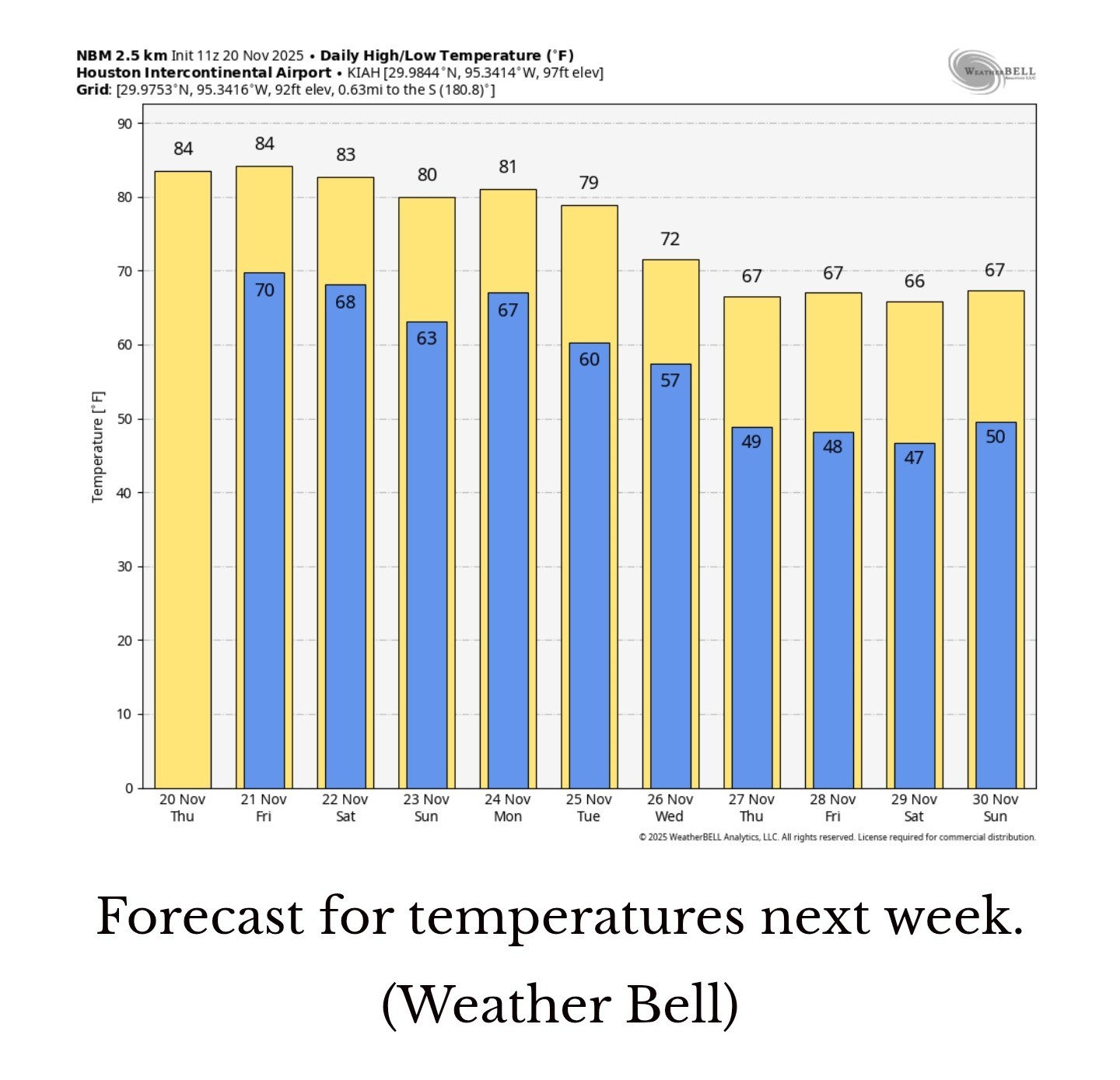 NEXT WEEK - Thanksgiving Day: 🦃🍽 MORNING: Clear with temperatures in the low 50s.
AFTERNOON: Mostly sunny skies with lower humidity & highs in the upper 60s. *The 'front' should lift back north on Sunday only to be followed by a second front that looks to be stronger. This will bring a healthy chance of rain on Monday and Monday night.
*By Tuesday or Wednesday we should see an influx of cooler and drier air.
*My prediction for Thanksgiving Day remains for morning temperatures in the lower 50s, with highs in the upper 60s. Skies should be mostly sunny. (Lows will bottom out on Friday and Saturday, probably) It should feel more like late November in Houston, finally. Precise details to come. ..... What is a STRATOSPHERIC warming event, anyway? In recent days there has been buzz about a sudden warming in the mid-levels of the atmosphere, about 5 to 25 mph above the surface, above the poles. This is the stratosphere, where the atmosphere is very thin. It lies above the troposphere, where we live, and most of our weather patterns develop. However, when there is a significant warming of the stratosphere over the poles it can influence conditions lower in the atmosphere. Such is the case with a "sudden stratospheric warming event." 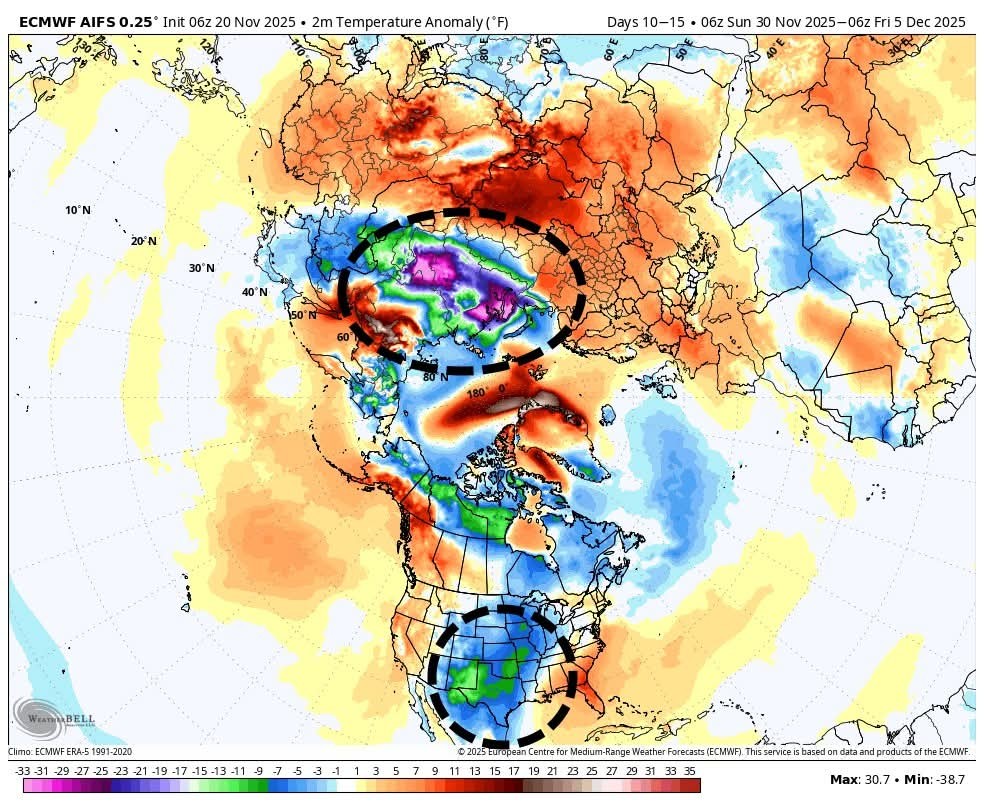 The first thing to understand is that that such events are poorly understood, both in terms of why they occur, and what their impacts are. However this stratospheric warming does, at times, lead to a weakening of the polar vortex that bottles up colder air at the poles of the planet. And it is possible that the present stratospheric warming event will weaken the polar vortex at the North Pole, and send some of this colder air shooting down into the Northern Hemisphere in about 10 days to two weeks. Some of our AI modeling guidance suggests this will happen over North America. However, it is equally plausible at this point that the colder air will be released into Europe or Asia. For example, in the AI version of the European model we see the most significantly colder air pushed into Russia, with a lesser helping slipping down into the United States. In this scenario it would bring near-freezing temperatures to the Houston area during the early days of December. However this is just one outcome, and we would strongly caution wariness about such long-range forecasts. FUNDRAISER - Our annual fundraiser is ongoing, and we greatly appreciate your support. Your donations and purchases are the primary means by which we operate the Space City Weather website, app, and more. For more information on how to donate or buy merchandise, please visit our website. Thank you! ☔️


SteveT, teatime and buffaloglenn + 7 more reacted *FRIDAY: Warm with a 50% chance of rain; totals expected to stay under one half inch. 🙄
*FRIDAY NIGHT: Showers overnight.
*WEEKEND: See detailed post below.
*Today's record high is 84 degrees, and we probably will tie this record today as well, if not beat it.
*There will be a slight chance of rain today and tonight, perhaps 10 or 20 percent. Any showers that develop will pass quickly.
*This afternoon will be windier, with gusts as high as 20 mph, from the south.
*Lows will only drop to around 70 degrees.
*A front will sag toward the area, and this will increase shower and (possibly) thunderstorm chances.
*Higher resolution models have really backed off on the potential for precipitation. I still think there's a 50 percent chance of rain on Friday and Friday night, but the overall rain totals will be on the lower side, with most areas probably picking up less than one-half inch through Saturday.
*Lows Friday night will remain warm, likely in the upper 60s.
*The presence of the stalled front will also mean that the region continues to see a decent chance of showers on Saturday, and possibly Sunday as well.
*These will not be wall to wall showers by any means, but should mostly be brief. However we can't rule out a few thunderstorms.
*Temperatures: Low 80s with partly sunny skies.
*Some inland areas may drop into the lower 60s on Saturday night as the front reaches its furthest extent.
AFTERNOON: Mostly sunny skies with lower humidity & highs in the upper 60s.
*By Tuesday or Wednesday we should see an influx of cooler and drier air.
*My prediction for Thanksgiving Day remains for morning temperatures in the lower 50s, with highs in the upper 60s. Skies should be mostly sunny. (Lows will bottom out on Friday and Saturday, probably)
Replies:
StormChaser : Thanks for the update! I always appreciate your clear explanation.
You are very best with your forecast. Many thanks!
Lulu45 :  StormChaser : Thanks for the update. We got a slight shower downtown earlier this morning but I blinked and it went away. lol.
Forecast update Unfortunately, models have backed way off on our rain totals for the next 4 days. *TODAY: Warm with a 20-30% chance of light, scattered showers. *FRIDAY: Warm with a 50% chance of rain; totals expected to stay under one half inch. 🙄 *FRIDAY NIGHT: Showers overnight. *WEEKEND: See detailed post below. 🦃 TURKEY DAY: Thanksgiving looks beautiful with sunny skies and highs in the 60s. .......... From Space City Weather: THURSDAY (TODAY) - *The city tied its record high of 85 degrees on Wednesday (previously set in 1985). *Today's record high is 84 degrees, and we probably will tie this record today as well, if not beat it. *Conditions will remain very humid, with partly to mostly cloudy skies. *There will be a slight chance of rain today and tonight, perhaps 10 or 20 percent. Any showers that develop will pass quickly. *This afternoon will be windier, with gusts as high as 20 mph, from the south. *Lows will only drop to around 70 degrees. FRIDAY (TOMORROW) - *This will be another warm day, with temperatures in the mid-80s. *A front will sag toward the area, and this will increase shower and (possibly) thunderstorm chances. *Higher resolution models have really backed off on the potential for precipitation. I still think there's a 50 percent chance of rain on Friday and Friday night, but the overall rain totals will be on the lower side, with most areas probably picking up less than one-half inch through Saturday. *Lows Friday night will remain warm, likely in the upper 60s. SATURDAY AND SUNDAY - The weak front is going to move into Houston and stall out. This will have some interesting and unpredictable effects on our weather this weekend. *It's likely that some areas inland of Interstate 10 will see some drier and briefly cooler air, with perhaps the maximum extent of this nose of drier air occurring on Saturday night into Sunday morning. *The presence of the stalled front will also mean that the region continues to see a decent chance of showers on Saturday, and possibly Sunday as well. *These will not be wall to wall showers by any means, but should mostly be brief. However we can't rule out a few thunderstorms. *Temperatures: Low 80s with partly sunny skies. *Some inland areas may drop into the lower 60s on Saturday night as the front reaches its furthest extent. NEXT WEEK - Thanksgiving Day: 🦃🍽 MORNING: Clear with temperatures in the low 50s. AFTERNOON: Mostly sunny skies with lower humidity & highs in the upper 60s. *The 'front' should lift back north on Sunday only to be followed by a second front that looks to be stronger. This will bring a healthy chance of rain on Monday and Monday night. *By Tuesday or Wednesday we should see an influx of cooler and drier air. *My prediction for Thanksgiving Day remains for morning temperatures in the lower 50s, with highs in the upper 60s. Skies should be mostly sunny. (Lows will bottom out on Friday and Saturday, probably) It should feel more like late November in Houston, finally. Precise details to come. ..... What is a STRATOSPHERIC warming event, anyway? In recent days there has been buzz about a sudden warming in the mid-levels of the atmosphere, about 5 to 25 mph above the surface, above the poles. This is the stratosphere, where the atmosphere is very thin. It lies above the troposphere, where we live, and most of our weather patterns develop. However, when there is a significant warming of the stratosphere over the poles it can influence conditions lower in the atmosphere. Such is the case with a "sudden stratospheric warming event." The first thing to understand is that that such events are poorly understood, both in terms of why they occur, and what their impacts are. However this stratospheric warming does, at times, lead to a weakening of the polar vortex that bottles up colder air at the poles of the planet. And it is possible that the present stratospheric warming event will weaken the polar vortex at the North Pole, and send some of this colder air shooting down into the Northern Hemisphere in about 10 days to two weeks. Some of our AI modeling guidance suggests this will happen over North America. However, it is equally plausible at this point that the colder air will be released into Europe or Asia. For example, in the AI version of the European model we see the most significantly colder air pushed into Russia, with a lesser helping slipping down into the United States. In this scenario it would bring near-freezing temperatures to the Houston area during the early days of December. However this is just one outcome, and we would strongly caution wariness about such long-range forecasts. FUNDRAISER - Our annual fundraiser is ongoing, and we greatly appreciate your support. Your donations and purchases are the primary means by which we operate the Space City Weather website, app, and more. For more information on how to donate or buy merchandise,  lease visit our website. Thank you! ☔️
lease visit our website. Thank you! ☔️StormChaser : I guess we just wait and watch. Thanks.
StormChaser : Thanks for the update. It's disappointing to miss out on the rain but I will happily skip storms and hail.
« Back to Chat
Views: 300
# Replies: 7