


Cool front + weekend forecast
Cool front + weekend forecast


Joined:
X days ago
# Posts:
X,XXX
Contributor Points:
X


Cool front + weekend forecast It doesn't get much better than this. 🩵🩵🩵🩵🩵🩵 Breezy and cooler today with an even stronger cold front likely on Sunday night. Eric Berger · Thursday, March 12, 2026 7:06 AM In brief: *Today we discuss our breezy conditions, which will lead to a chilly night.
*Also, after days of clouds we are likely to see sunshine prevail for awhile now in Houston.
*After a warm-up this weekend I expect an even sharper cold front early next week that may return temperatures in the 30s briefly. 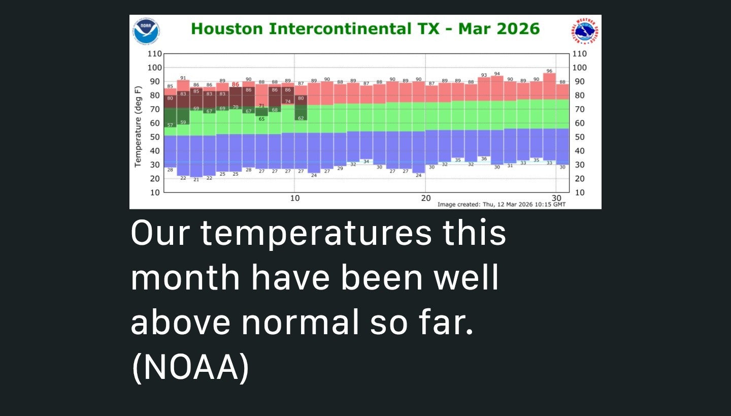 COOLER FOR THE NEXT WEEK - *The first third of March has been ridiculously warm, with an average temperature running 13 degrees above normal, and one night during which lows did not fall below the mid-70s.
*Anyway, for the next week so, this will largely be behind us.
*Wednesday night's front will bring us a chilly couple of chilly nights.
*An even stronger front on Sunday night will bring still colder conditions early next week.
*Some locations may reach the upper 30s in what I suspect will be our final brush with anything below the mid-40s for the rest of spring.
*So knowing what lies ahead over the next six or seven months, if you like the colder conditions, now is the time to venture outside. THURSDAY - *The strongest winds moved through overnight, with gusts up to 40 mph in many locations.
*These winds have backed off a little this morning, and will continue to slowly subside today before ebbing completely this evening.
*Skies are clear, and this should allow high temperatures to reach the upper 60s this afternoon with really dry air. HOUSTON RODEO WEATHER 🤠 *Temperatures will be about 60 degrees before the show this evening at the Houston Livestock Show and Rodeo, and fortunately winds will have died down by then.
*It will be chilly afterwards, with clear skies, light winds, and temperatures in the mid-50s.
*Lows will drop a little further overnight, into the upper 40s in most of Houston, with cooler conditions further inland and a bit warmer near the coast. 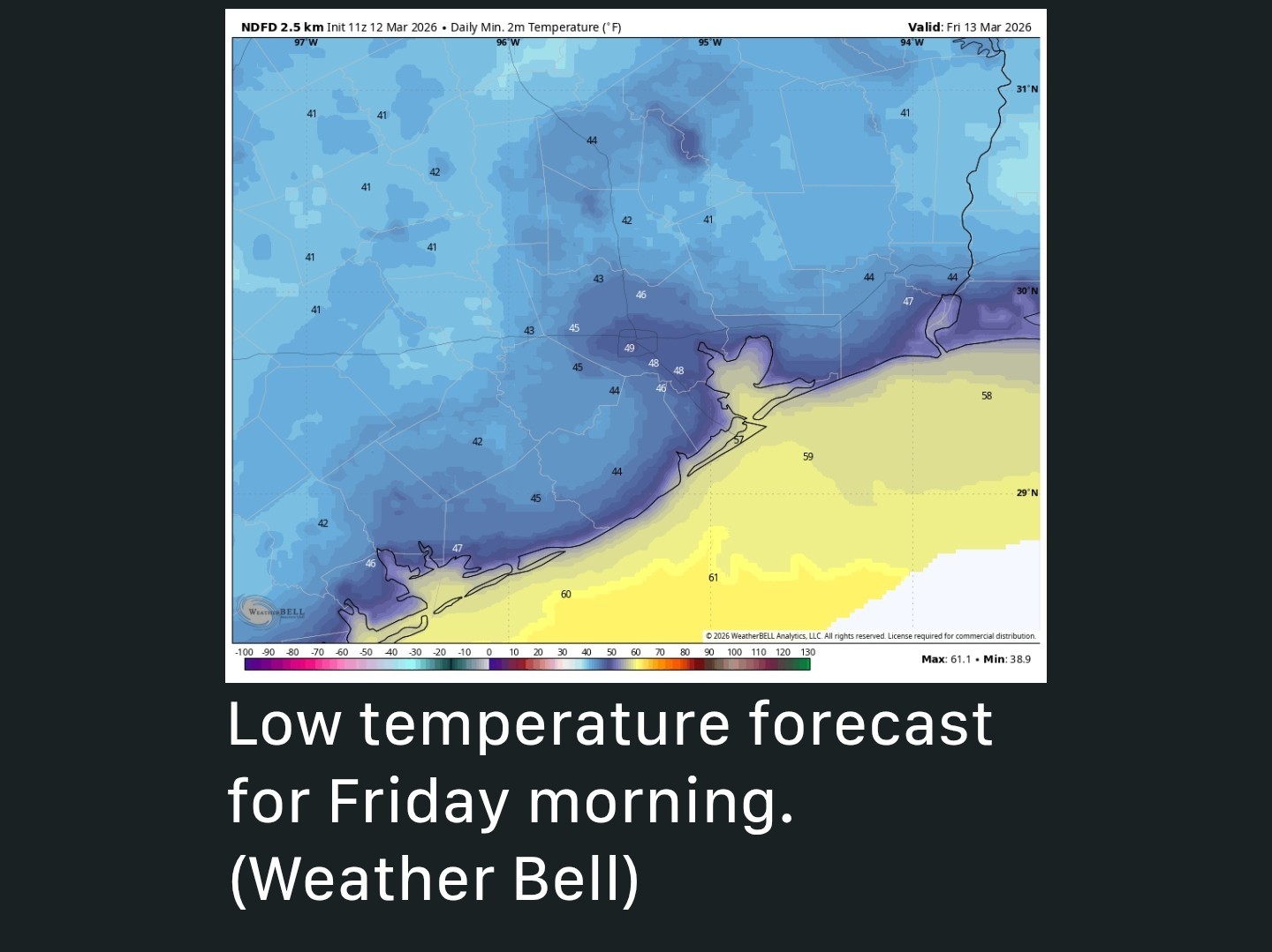 FRIDAY - *This will be an exceptional day, period.
*Look for highs in the mid-70s, sunny skies, light winds, and low humidity.
*I'm not sure it gets better than that. It probably will be one of the 10 nicest days of the year in Houston.
*Overnight lows will drop into the mid-50s as the onshore flow resumes. SATURDAY and SUNDAY - *These will be a pair of sunny days.
*Saturday will probably max out around 80 degrees, with Sunday pushing into the mid-80s.
*Winds will generally be from the south, at around 10 mph, with higher gusts.
*A strong cold front will push through at the end of the weekend, probably on Sunday evening.
*This may bring a brief period of light rain during the afternoon or evening before northerly winds blow everything offshore.
*Lows on Monday should drop into the 40s. NEXT WEEK - *The first half of next week looks rather chilly, and I could see some scenarios in which lows for much of Houston fall into the upper 30s on Tuesday morning. (It could also easily be in the lower 40s).
*The bottom line is that it will be be cold for this time of year, and especially so after the month's abnormally warm start.
*We should climb back to daily highs of around 80 degrees by Thursday or Friday of next week.
*For the remainder of next week I don't expect much if any precipitation after the front on Sunday evening (which again, probably won't bring much with it either).

PlaneCrazy, Texasota and golfshot + 2 more reacted *Also, after days of clouds we are likely to see sunshine prevail for awhile now in Houston.
*After a warm-up this weekend I expect an even sharper cold front early next week that may return temperatures in the 30s briefly.
*Anyway, for the next week so, this will largely be behind us.
*Wednesday night's front will bring us a chilly couple of chilly nights.
*An even stronger front on Sunday night will bring still colder conditions early next week.
*Some locations may reach the upper 30s in what I suspect will be our final brush with anything below the mid-40s for the rest of spring.
*So knowing what lies ahead over the next six or seven months, if you like the colder conditions, now is the time to venture outside.
*These winds have backed off a little this morning, and will continue to slowly subside today before ebbing completely this evening.
*Skies are clear, and this should allow high temperatures to reach the upper 60s this afternoon with really dry air.
*It will be chilly afterwards, with clear skies, light winds, and temperatures in the mid-50s.
*Lows will drop a little further overnight, into the upper 40s in most of Houston, with cooler conditions further inland and a bit warmer near the coast.
*Look for highs in the mid-70s, sunny skies, light winds, and low humidity.
*I'm not sure it gets better than that. It probably will be one of the 10 nicest days of the year in Houston.
*Overnight lows will drop into the mid-50s as the onshore flow resumes.
*Saturday will probably max out around 80 degrees, with Sunday pushing into the mid-80s.
*Winds will generally be from the south, at around 10 mph, with higher gusts.
*A strong cold front will push through at the end of the weekend, probably on Sunday evening.
*This may bring a brief period of light rain during the afternoon or evening before northerly winds blow everything offshore.
*Lows on Monday should drop into the 40s.
*The bottom line is that it will be be cold for this time of year, and especially so after the month's abnormally warm start.
*We should climb back to daily highs of around 80 degrees by Thursday or Friday of next week.
*For the remainder of next week I don't expect much if any precipitation after the front on Sunday evening (which again, probably won't bring much with it either).
Replies:
« Back to Chat
Views: 175
# Replies: 1