


It's coming......
It's coming......


Joined:
X days ago
# Posts:
X,XXX
Contributor Points:
X


It's coming...... Cooler weather is almost here....along with fairly gusty winds. I'm not trying to be a downer but I wouldn't be surprised if we have some power outages due to 30-40mph wind gusts today. At least you can open the windows! 😁 From Space City Weather - Hellooooo, Fall! Soak up this weekend Houston, you've earned it. Matt Lanza · Friday, October 16, 2026 5:46 AM 👉In brief: *Autumn arrives in the Houston area today, with plummeting humidity and comfortable, if not cool temperatures this weekend!
*While next week offers a warming trend, humidity levels and morning lows stay under control, allowing for continued mostly pleasant, warmer weather. 👉FALL'S FIRST REAL front - Welcome to autumn, my friends! *As of this writing, our much discussed cold front has entered Grimes, northern Waller, and northwest Montgomery Counties.
*We will now get multiple days of comfortable, pleasant autumn weather, so get outside and enjoy it. *Indeed, temperatures have fallen in the Brazos Valley with 60s now in College Station as of 5:30 AM.
*Temperatures are as much as 20 degrees cooler than they were 24 hours ago just west of I-35 in Central Texas. It's coming. 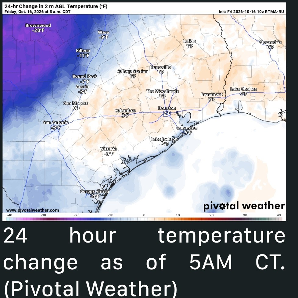 👉TODAY & TONIGHT - *Before the front hits, look for a few scattered showers or a thunderstorm.
*The wind will crank up as well. Calm winds this morning will shift out of the north and will gust at 30 to 35 mph behind the front, stronger perhaps on Galveston Island, by Galveston Bay, or in the Brazos Valley. 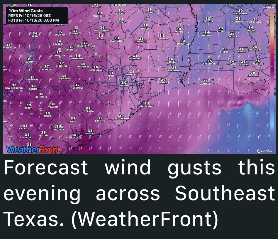 *Temperatures in the low-70s this morning may drop back into the upper 60s in spots today but generally, they'll hang near 70 degrees.
*Dewpoints will fall into the 40s this evening making it feel exquisite, albeit windy.
*Look for overnight lows to drop down into the 50s everywhere, even Galveston with some pockets of 40s possible in the usual colder spots. 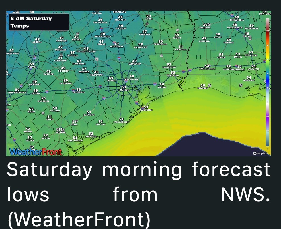 *In terms of clouds vs sun, we should see more clouds than sun this morning and more sun than clouds this afternoon. 👉SATURDAY and SUNDAY - Perfect. That's about all we need to say. *Winds will remain a little gusty on Saturday, though not as strong as today, and they'll back off even more on Sunday.
*Highs around 70 on Saturday, lows around 45 to 50 away from the water on Sunday morning.
*Highs will be in the low to mid-70s on Sunday afternoon. 👉NEXT WEEK - *For those of you that enjoy Houston for warmer weather than this weekend provides, next week should be a return to warmer conditions.
*Look for a slow increase in both temperature and humidity, though probably not returning anywhere close to the levels we have been dealing with.
*I expect to see highs near 80 on Monday, the low to mid 80s on Tuesday, and the mid-80s on Wednesday.
*Morning lows will also slowly nudge up to the mid-50s Monday, near 60 Tuesday, and the low-60s Wednesday.
*Some overnight guidance tries to keep lows in the 50s through Wednesday.
*Usually we end up warming back up a little faster than expected in these scenarios so I'll keep us warm for now and Eric can tell you I was wrong on Monday.
*That said, despite the warming trend, we are probably now at the point on the calendar where even on hotter days, the evenings and mornings aren't half bad.
*The week looks rain-free at this time as well. Live temperatures -


golfshot, AggieBandMom and Txbutterfly + 4 more reacted ***********************
*While next week offers a warming trend, humidity levels and morning lows stay under control, allowing for continued mostly pleasant, warmer weather.
*We will now get multiple days of comfortable, pleasant autumn weather, so get outside and enjoy it.
*Temperatures are as much as 20 degrees cooler than they were 24 hours ago just west of I-35 in Central Texas.
*The wind will crank up as well. Calm winds this morning will shift out of the north and will gust at 30 to 35 mph behind the front, stronger perhaps on Galveston Island, by Galveston Bay, or in the Brazos Valley.
*Dewpoints will fall into the 40s this evening making it feel exquisite, albeit windy.
*Look for overnight lows to drop down into the 50s everywhere, even Galveston with some pockets of 40s possible in the usual colder spots.
*Highs around 70 on Saturday, lows around 45 to 50 away from the water on Sunday morning.
*Highs will be in the low to mid-70s on Sunday afternoon.
*Look for a slow increase in both temperature and humidity, though probably not returning anywhere close to the levels we have been dealing with.
*I expect to see highs near 80 on Monday, the low to mid 80s on Tuesday, and the mid-80s on Wednesday.
*Morning lows will also slowly nudge up to the mid-50s Monday, near 60 Tuesday, and the low-60s Wednesday.
*Some overnight guidance tries to keep lows in the 50s through Wednesday.
*Usually we end up warming back up a little faster than expected in these scenarios so I'll keep us warm for now and Eric can tell you I was wrong on Monday.
*That said, despite the warming trend, we are probably now at the point on the calendar where even on hotter days, the evenings and mornings aren't half bad.
*The week looks rain-free at this time as well.
🔴 Texas Weather Live 24/7 | Live Radar, Severe Alerts & Texas Forecasts
Replies:


|
#msg6032231StormChaser : I am so glad it's getting cooler!!
KanKan :
StormChaser : My boyfriends flight lands around 930-10am. Hopefully the winds aren't too crazy. I bet I'll hear all about it when I go pick him up lol
« Back to Chat
Views: 132
# Replies: 6