


This week's forecast
This week's forecast


Joined:
X days ago
# Posts:
X,XXX
Contributor Points:
X


This week's forecast It's gorgeous out this morning! 🍁🍁🍁🍁🍁 A little more fall-like in Houston, but still some warmer temps and humidity to come. Matt Lanza · Monday, October 5, 2026 5:52 AM 👉IN BRIEF: *A warmer and sunnier stretch of weather should await the Houston area this week, albeit with lower humidity levels.
*The tropics are not a concern for us at this time, with any Gulf tropical system likely staying well to our south and east.
*We turn hotter and more humid this weekend and early next week. *I don't know if Sunday was the unofficial first fall day in Houston, but the weather behaved that way to an extent.
*Overcast skies, some light rain and drizzle, and the hangover of a disappointing sports week seemed to make it so.
*Our high temperature yesterday was 81°, the coolest daytime high since July 14th, when we only hit 79°.
*This type of weather won't last, however, as we move into something of a more typical warm autumn setup for the rest of this week. 👉TODAY - *We have some lingering clouds this morning and those clouds may be a bit stubborn, especially south and east of Houston.
*There will continue to be a shower chance to the southeast too with the cool front sitting just offshore.
*Overall we'll call today partly cloudy to perhaps eventually mostly sunny, with highs likely bouncing back into the mid-80s. 👉TUESDAY, WEDNESDAY, and THURSDAY - *As of now we expect all three days to be generally partly cloudy to mostly sunny.
*Highs will probably be in the upper 80s.
*Morning lows may not be too bad on Tuesday, with a chance that some places outside of Beltway 8 drop into the mid 60s. 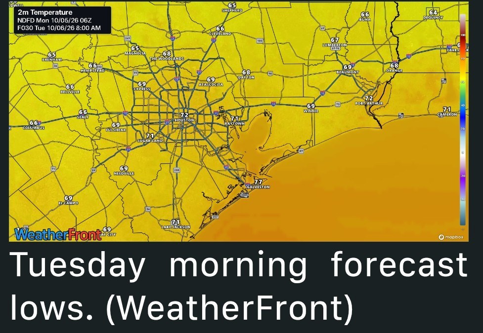 *Daytimes will be hot with those upper-80s, but the humidity levels will be less oppressive and more typical for October.
*There could be some showers, especially by Wednesday or Thursday, and especially south and east of Houston each afternoon. 👉TROPICS & LATE WEEK THROUGH through THE WEEKEND - *I wrote about the tropical disturbance in the southwest Gulf and Bay of Campeche yesterday at The Eyewall.
*I'll have another update on that later today or tonight. 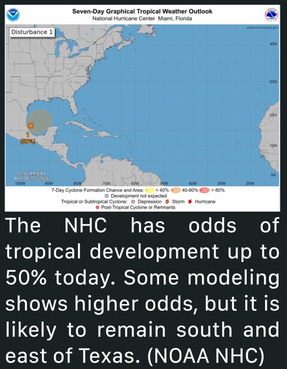 *The short takeaway is that we should not need to worry much about this system here in Texas.
*With a front draped offshore, and general southwest to northeast flow pattern, whatever happens there, be it a slopfest of moisture or a stronger tropical storm or hurricane will likely be carried to our east.
*This is also well reflected in the model forecast of precipitation anomalies, which you can see over the next 7 to 10 days will likely end up well above normal south and east of our area. 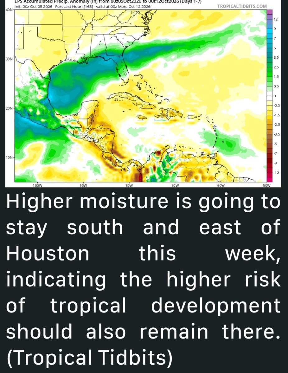 *So for Houston, this means that we will probably continue with these seasonably warm temperatures that may gradually trend to more unseasonably warm as we go toward the weekend and next week.
*We'll probably see the humidity return late this week as well.
*This time, however, it does look at a front or fronts will break things up sometime next week.
*We're beginning to see the pace of fronts slowly increase, which should mean that any higher humidity periods should be shorter-lived than they have been since September.


CatalinaD, Txbutterfly and Kittle + 2 more reacted *The tropics are not a concern for us at this time, with any Gulf tropical system likely staying well to our south and east.
*We turn hotter and more humid this weekend and early next week.
*Overcast skies, some light rain and drizzle, and the hangover of a disappointing sports week seemed to make it so.
*Our high temperature yesterday was 81°, the coolest daytime high since July 14th, when we only hit 79°.
*This type of weather won't last, however, as we move into something of a more typical warm autumn setup for the rest of this week.
*There will continue to be a shower chance to the southeast too with the cool front sitting just offshore.
*Overall we'll call today partly cloudy to perhaps eventually mostly sunny, with highs likely bouncing back into the mid-80s.
*Highs will probably be in the upper 80s.
*Morning lows may not be too bad on Tuesday, with a chance that some places outside of Beltway 8 drop into the mid 60s.
*There could be some showers, especially by Wednesday or Thursday, and especially south and east of Houston each afternoon.
*I'll have another update on that later today or tonight.
*With a front draped offshore, and general southwest to northeast flow pattern, whatever happens there, be it a slopfest of moisture or a stronger tropical storm or hurricane will likely be carried to our east.
*This is also well reflected in the model forecast of precipitation anomalies, which you can see over the next 7 to 10 days will likely end up well above normal south and east of our area.
*We'll probably see the humidity return late this week as well.
*This time, however, it does look at a front or fronts will break things up sometime next week.
*We're beginning to see the pace of fronts slowly increase, which should mean that any higher humidity periods should be shorter-lived than they have been since September.
Replies:

|
 StormChaser :
 Thanks for the forecast. Been thankful for the rain and lower humidity. Ready for more cool fronts. Have a blessed day!
 StormChaser :
 The weather was absolutely delightful when we were taking our morning walk. Thankfully we did get some much needed rain yesterday.
#msg6023089This week's forecast It's gorgeous out this morning! 🍁🍁🍁🍁🍁 A little more fall-like in Houston, but still some warmer temps and humidity to come. Matt Lanza · Monday, October 5, 2026 5:52 AM 👉IN BRIEF: *A warmer and sunnier stretch of weather should await the Houston area this week, albeit with lower humidity levels. *The tropics are not a concern for us at this time, with any Gulf tropical system likely staying well to our south and east. *We turn hotter and more humid this weekend and early next week. *I don't know if Sunday was the unofficial first fall day in Houston, but the weather behaved that way to an extent. *Overcast skies, some light rain and drizzle, and the hangover of a disappointing sports week seemed to make it so. *Our high temperature yesterday was 81°, the coolest daytime high since July 14th, when we only hit 79°. *This type of weather won't last, however, as we move into something of a more typical warm autumn setup for the rest of this week. 👉TODAY - *We have some lingering clouds this morning and those clouds may be a bit stubborn, especially south and east of Houston. *There will continue to be a shower chance to the southeast too with the cool front sitting just offshore. *Overall we'll call today partly cloudy to perhaps eventually mostly sunny, with highs likely bouncing back into the mid-80s. 👉TUESDAY, WEDNESDAY, and THURSDAY - *As of now we expect all three days to be generally partly cloudy to mostly sunny. *Highs will probably be in the upper 80s. *Morning lows may not be too bad on Tuesday, with a chance that some places outside of Beltway 8 drop into the mid 60s. *Daytimes will be hot with those upper-80s, but the humidity levels will be less oppressive and more typical for October. *There could be some showers, especially by Wednesday or Thursday, and especially south and east of Houston each afternoon. 👉TROPICS & LATE WEEK THROUGH through THE WEEKEND - *I wrote about the tropical disturbance in the southwest Gulf and Bay of Campeche yesterday at The Eyewall. *I'll have another update on that later today or tonight. *The short takeaway is that we should not need to worry much about this system here in Texas. *With a front draped offshore, and general southwest to northeast flow pattern, whatever happens there, be it a slopfest of moisture or a stronger tropical storm or hurricane will likely be carried to our east. *This is also well reflected in the model forecast of precipitation anomalies, which you can see over the next 7 to 10 days will likely end up well above normal south and east of our area. *So for Houston, this means that we will probably continue with these seasonably warm temperatures that may gradually trend to more unseasonably warm as we go toward the weekend and next week. *We'll probably see the humidity return late this week as well. *This time, however, it does look at a front or fronts will break things up sometime next week. *We're beginning to see the pace of fronts slowly increase, which should mean that any higher humidity periods should be shorter-lived than they have been since September.
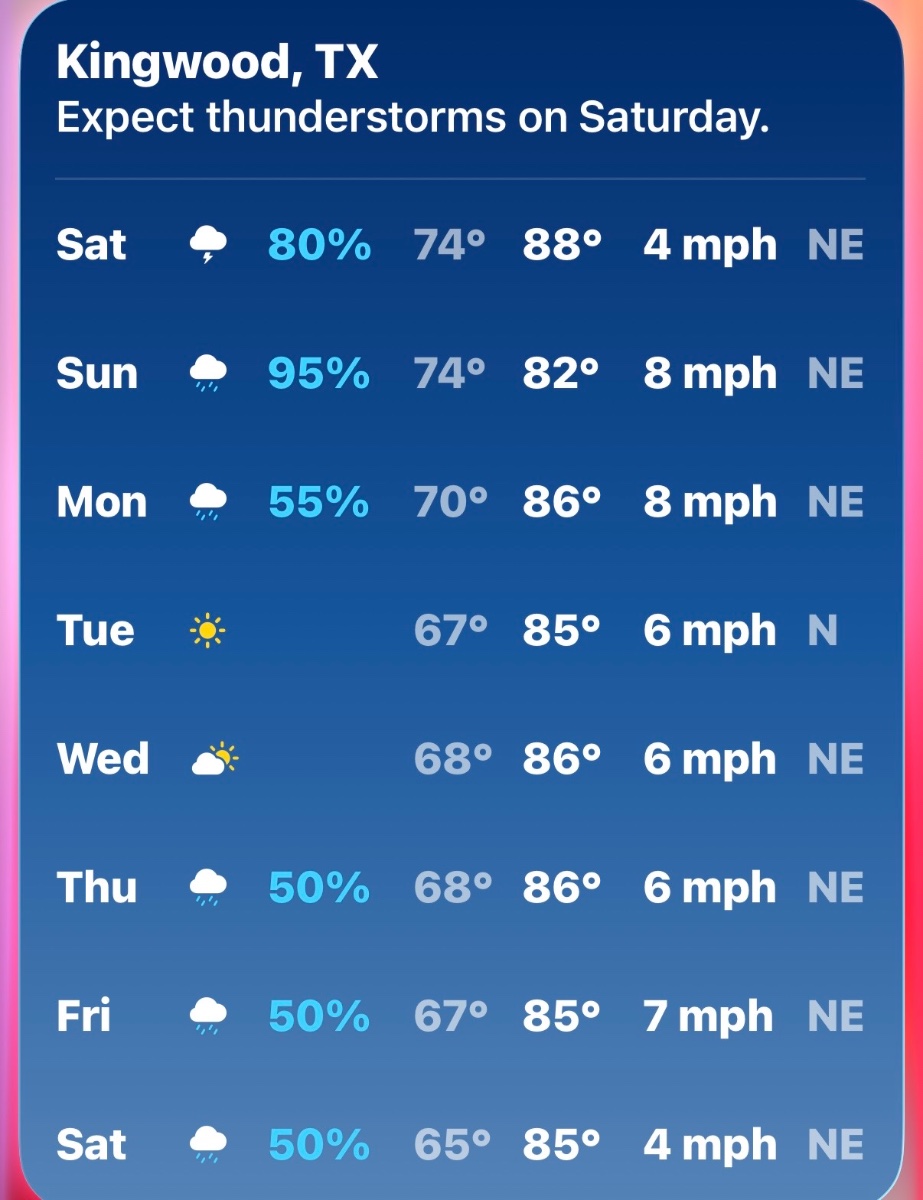
StormChaser : wait so this is a tease?
« Back to Chat
Views: 72
# Replies: 5