


This week's forecast
This week's forecast


Joined:
X days ago
# Posts:
X,XXX
Contributor Points:
X


This week's forecast - Heavy rainfall likely Thursday through Sunday due to the remnants of Hurricane Polo.
- Flooding threat should stay well to our north. (Dallas could see 12+ inches) and we're forecast to see 1-4 inches. 👉From Space City Weather - Heavy rains are inbound to Texas this week, with flooding likely in central parts of the state. Eric Berger · Monday, September 28, 2026 6:18 AM 👉IN BRIEF: In today's post we take a broader look at rains expected to move into Texas from the remains of a Pacific hurricane, and look ahead to cooler and wetter weather across the Houston region toward the end of this week. 👉Polo's remains bring Texas rains - *Hurricane Polo, a powerful storm in the Pacific Ocean, is about to make landfall over Baja Peninsula and then will move toward Texas over the next couple of days.
*There it will bring the potential for heavy rainfall.
*Houston, under less of a threat, will see rains later this week, which we'll discuss below.
*But to start I wanted to highlight the threat from Polo to central Texas. The following is a snippet from our companion site, 👉The Eyewall: theeyewall.com/ 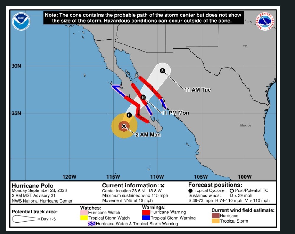 *Copious amounts of moisture will surge into the Desert Southwest and eventually the Southern Plains and Texas from Hurricane Polo.
*The moisture from Polo and a slow or stalling cold front will probably focus repeating rounds of rain from Hill Country into North Texas.
*Those areas are already under a moderate risk (level 3/4) for flash flooding on Wednesday, and that will likely extend into Thursday as well. 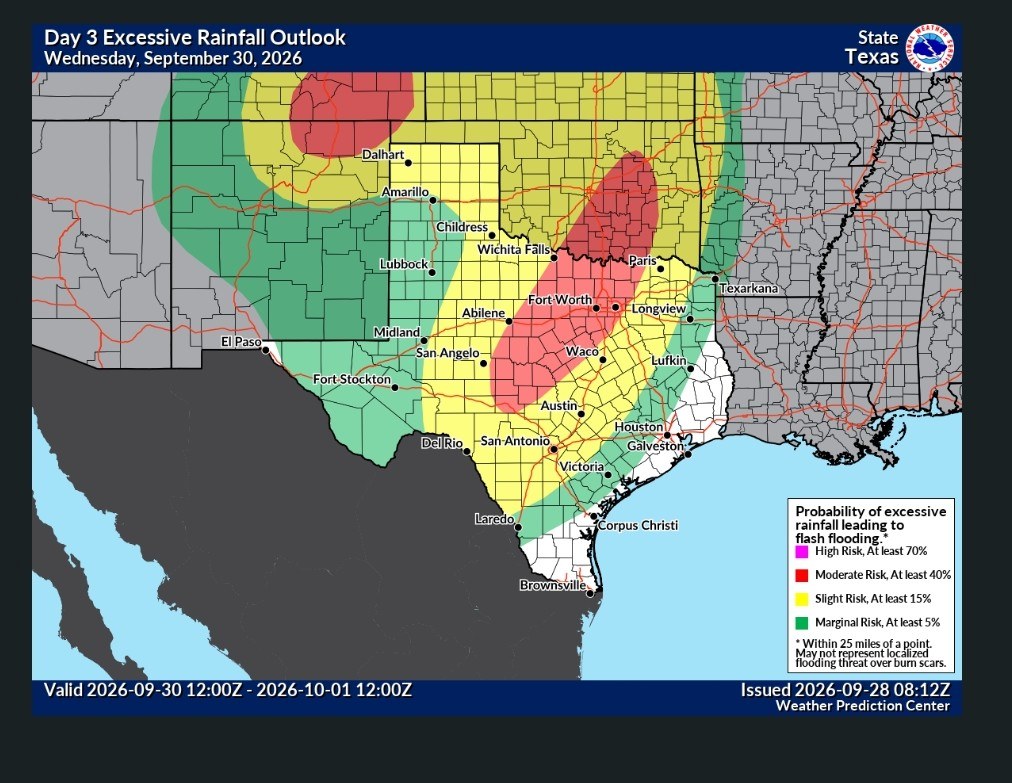 *Rain totals are likely to end up in the 4 to 8 inch range from south of San Antonio through Dallas and perhaps up toward Durant, OK through Friday.
*There is a chance that some areas see as much as 10 to 12 inches though, as we know Texas flood history is littered with these types of remnant Pacific hurricane events. 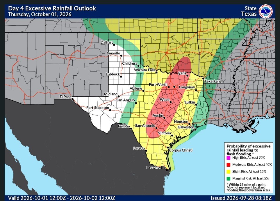 *For now the more serious flooding concerns are likely to stay north and west of the Houston region.
*Texas folks in Hill Country and the Metroplex should monitor the next couple days of forecasts very closely and be prepared for disruptions on Wednesday and Thursday. 👉MONDAY, TUESDAY, and WEDNESDAY - *Locally, we don't expect too much rainfall over the next few days.
*Rain chances through Wednesday will be on the lower end, probably 20 to 30 percent each day.
*Yes, there could be a few more clouds, and we certainly cannot rule out some thunderstorms, but any moisture related to Polo should remain well to our west.
*Highs each day will be in the low- to mid-90s with plenty of humidity.
*Nights will be muggy, in the upper 70s for the most part. 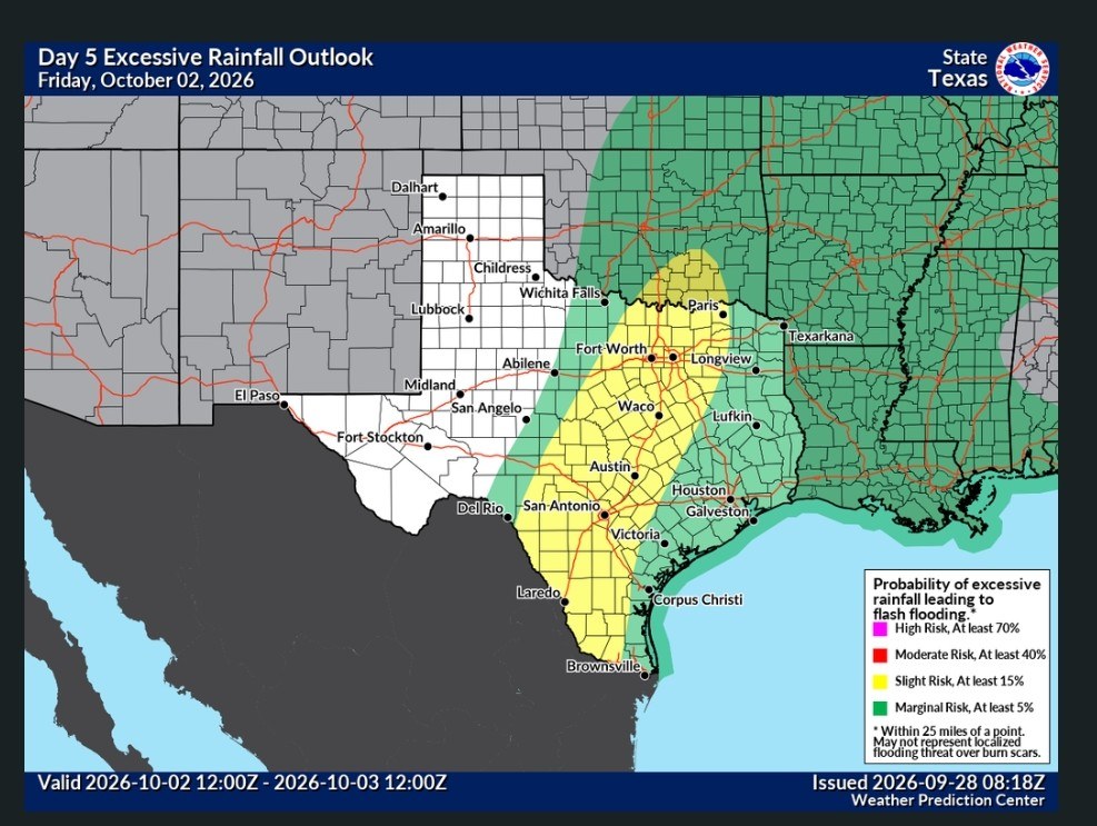 👉THURSDAY, FRIDAY, SATURDAY, and SUNDAY - *This is the period when we expect improved rain chances across the Houston region as available moisture in the atmosphere surges upward.
*Unfortunately, I cannot give you a precisely detailed forecast for each day.
*However, rain chances should be 50 percent or above, with with partly to mostly cloudy skies.
*At this point Friday appears likely to have the best overall chance for rain, but this could shift over the next couple of days.
*In terms of overall accumulations, they will vary widely, but I expect most of the Houston region to pick up 1 to 4 inches of rainfall through Sunday.
*Again we'll need to fine tune this forecast as we get closer. *In terms of daily temperatures, the cloud cover, rain, and a weak front should help pull highs down into the 80s on most days, with overnight lows in the mid-70s.
*So basically we'll be at pretty seasonable levels for early October. 👉NEXT WEEK - *The rains should subside by Monday or Tuesday of next week, after which point something of a stronger front may arrive to possibly push nights into the 60s during the second half of the week.
*More on that in the coming days as we get more clarity on the situation.

Rocketgirl13, teatime and Jeepinbear + 2 more reacted - Flooding threat should stay well to our north. (Dallas could see 12+ inches) and we're forecast to see 1-4 inches.
*********************
*There it will bring the potential for heavy rainfall.
*Houston, under less of a threat, will see rains later this week, which we'll discuss below.
*But to start I wanted to highlight the threat from Polo to central Texas.
*The moisture from Polo and a slow or stalling cold front will probably focus repeating rounds of rain from Hill Country into North Texas.
*Those areas are already under a moderate risk (level 3/4) for flash flooding on Wednesday, and that will likely extend into Thursday as well.
*There is a chance that some areas see as much as 10 to 12 inches though, as we know Texas flood history is littered with these types of remnant Pacific hurricane events.
*Texas folks in Hill Country and the Metroplex should monitor the next couple days of forecasts very closely and be prepared for disruptions on Wednesday and Thursday.
*Rain chances through Wednesday will be on the lower end, probably 20 to 30 percent each day.
*Yes, there could be a few more clouds, and we certainly cannot rule out some thunderstorms, but any moisture related to Polo should remain well to our west.
*Highs each day will be in the low- to mid-90s with plenty of humidity.
*Nights will be muggy, in the upper 70s for the most part.
*Unfortunately, I cannot give you a precisely detailed forecast for each day.
*However, rain chances should be 50 percent or above, with with partly to mostly cloudy skies.
*At this point Friday appears likely to have the best overall chance for rain, but this could shift over the next couple of days.
*In terms of overall accumulations, they will vary widely, but I expect most of the Houston region to pick up 1 to 4 inches of rainfall through Sunday.
*Again we'll need to fine tune this forecast as we get closer.
*So basically we'll be at pretty seasonable levels for early October.
*More on that in the coming days as we get more clarity on the situation.
Replies:

« Back to Chat
Views: 64
# Replies: 1