


This week's forecast
This week's forecast


Joined:
X days ago
# Posts:
X,XXX
Contributor Points:
X


This week's forecast A day late but here it is. 😊 👉 Storms forecasted for early Thursday AM. From Space City Weather: TUESDAY - *In addition to rising humidity, temperatures today will also be climbing.
*How warm will depend on how much clouds break up this afternoon.
*For most of us, temperatures will range from the low to mid-80s, but sunnier spots could rise into the upper-80s.
*It's also going to be breezy, with gusty winds from the south as high as 25 mph later this morning.
*Rain chances are less than 10 percent.
*Clouds return this evening, with lows only dropping into the mid-70s. WEDNESDAY & THURSDAY - *Wednesday will be another humid day, with highs likely reaching the mid to upper-80s.
*With increasing moisture levels we are going to see some scattered showers, but I don't think it will be anything too serious.
*A cold front will approach the region later on Wednesday, but the overall trend in the models has been slower.
*Therefore, although some storms may be possible Wednesday night, it now appears as though this activity will be delayed into Thursday morning when this front sags into Houston.
*Bottom line - it looks like the best chance for rain and potentially storms will come on Thursday in association with the front.
*In terms of accumulations most of us will probably get 1 inch or less, so flooding does not appear to be a major concern.
*We're going to keep an eye on things because a slow moving front and ample moisture can always cause some problems.
*Highs Thursday should top out in the upper 70s with lows Thursday night should be a little cooler, perhaps in the 60s. FRIDAY - *A healthy chance of showers and possibly thunderstorms lingers on Friday, with mostly cloudy skies and highs near 80 degrees.
*The air will be slightly less humid (i.e. dewpoints in the 60s). 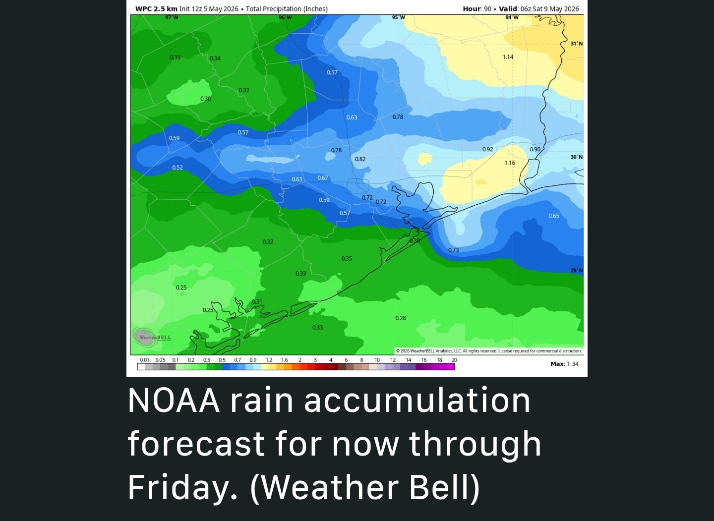 SATURDAY and SUNDAY - *I'm starting to have a little more confidence in the weekend forecast, but don't write things down in ink just yet.
*Saturday should be mostly sunny, with highs in the low to mid-80s.
*At this time I'm cautiously optimistic that things look good-to-go for most outdoor activities.
*Sunday looks pretty hot, with highs inching up toward 90 degrees, depending on the extent of sunshine we see.
*There will be at least a slight chance of showers and thunderstorms on Sunday.


peppermintstick, Txbutterfly and cbear reacted *How warm will depend on how much clouds break up this afternoon.
*For most of us, temperatures will range from the low to mid-80s, but sunnier spots could rise into the upper-80s.
*It's also going to be breezy, with gusty winds from the south as high as 25 mph later this morning.
*Rain chances are less than 10 percent.
*Clouds return this evening, with lows only dropping into the mid-70s.
*With increasing moisture levels we are going to see some scattered showers, but I don't think it will be anything too serious.
*A cold front will approach the region later on Wednesday, but the overall trend in the models has been slower.
*Therefore, although some storms may be possible Wednesday night, it now appears as though this activity will be delayed into Thursday morning when this front sags into Houston.
*Bottom line - it looks like the best chance for rain and potentially storms will come on Thursday in association with the front.
*In terms of accumulations most of us will probably get 1 inch or less, so flooding does not appear to be a major concern.
*We're going to keep an eye on things because a slow moving front and ample moisture can always cause some problems.
*Highs Thursday should top out in the upper 70s with lows Thursday night should be a little cooler, perhaps in the 60s.
*The air will be slightly less humid (i.e. dewpoints in the 60s).
*Saturday should be mostly sunny, with highs in the low to mid-80s.
*At this time I'm cautiously optimistic that things look good-to-go for most outdoor activities.
*Sunday looks pretty hot, with highs inching up toward 90 degrees, depending on the extent of sunshine we see.
*There will be at least a slight chance of showers and thunderstorms on Sunday.
Replies:

|

#msg5912476This week's forecast A day late but here it is. 😊 👉 Storms forecasted for early Thursday AM. From Space City Weather: TUESDAY - *In addition to rising humidity, temperatures today will also be climbing. *How warm will depend on how much clouds break up this afternoon. *For most of us, temperatures will range from the low to mid-80s, but sunnier spots could rise into the upper-80s. *It's also going to be breezy, with gusty winds from the south as high as 25 mph later this morning. *Rain chances are less than 10 percent. *Clouds return this evening, with lows only dropping into the mid-70s. WEDNESDAY & THURSDAY - *Wednesday will be another humid day, with highs likely reaching the mid to upper-80s. *With increasing moisture levels we are going to see some scattered showers, but I don't think it will be anything too serious. *A cold front will approach the region later on Wednesday, but the overall trend in the models has been slower. *Therefore, although some storms may be possible Wednesday night, it now appears as though this activity will be delayed into Thursday morning when this front sags into Houston. *Bottom line - it looks like the best chance for rain and potentially storms will come on Thursday in association with the front. *In terms of accumulations most of us will probably get 1 inch or less, so flooding does not appear to be a major concern. *We're going to keep an eye on things because a slow moving front and ample moisture can always cause some problems. *Highs Thursday should top out in the upper 70s with lows Thursday night should be a little cooler, perhaps in the 60s. FRIDAY - *A healthy chance of showers and possibly thunderstorms lingers on Friday, with mostly cloudy skies and highs near 80 degrees. *The air will be slightly less humid (i.e. dewpoints in the 60s). SATURDAY and SUNDAY - *I'm starting to have a little more confidence in the weekend forecast, but don't write things down in ink just yet. *Saturday should be mostly sunny, with highs in the low to mid-80s. *At this time I'm cautiously optimistic that things look good-to-go for most outdoor activities. *Sunday looks pretty hot, with highs inching up toward 90 degrees, depending on the extent of sunshine we see. *There will be at least a slight chance of showers and thunderstorms on Sunday.
StormChaser : It is so gloomy today. Oh well, clouds keep the sun out and keep us a bit cooler.
|
|
Hopefully we don't get that much rain at my house. We got enough last week and my yard is just now starting to dry out.
« Back to Chat
Views: 142
# Replies: 2