


This week's forecast
This week's forecast


Joined:
X days ago
# Posts:
X,XXX
Contributor Points:
X


This week's forecast After weeks of no rain, are we really going to get a soggy Easter Sunday? ☔️🐣🐰 Eric Berger · Monday, March 30, 2026 6:50 AM In brief: In today's forecast we note that Houston's last measurable rainfall occurred nearly three weeks ago for most of the region - That almost certainly will end this week, with the threat of some showers lingering into Easter Sunday. Easter Sunday 🐣🐰 *For most of Houston, our last measurable rainfall came on March 11, and it is unlikely to rain for another day or two at least.
*As we discussed on Friday, parts of the Houston area have already reached "extreme" drought status, and more will follow without significant rainfall soon.
*High pressure has been dominant of late, but that should change this week, allowing for somewhat increased rain chances on Wednesday and Thursday.
*Our best chances will come this weekend, with the passage of a decently strong front.
*This may bring 0.5 to 1.5 inch into the area. But when will it fall? That will depend on the timing of the front. *Right now I'd guess sometime on Saturday night, yet even if that's the case we could see showers lingering into Easter Sunday morning. 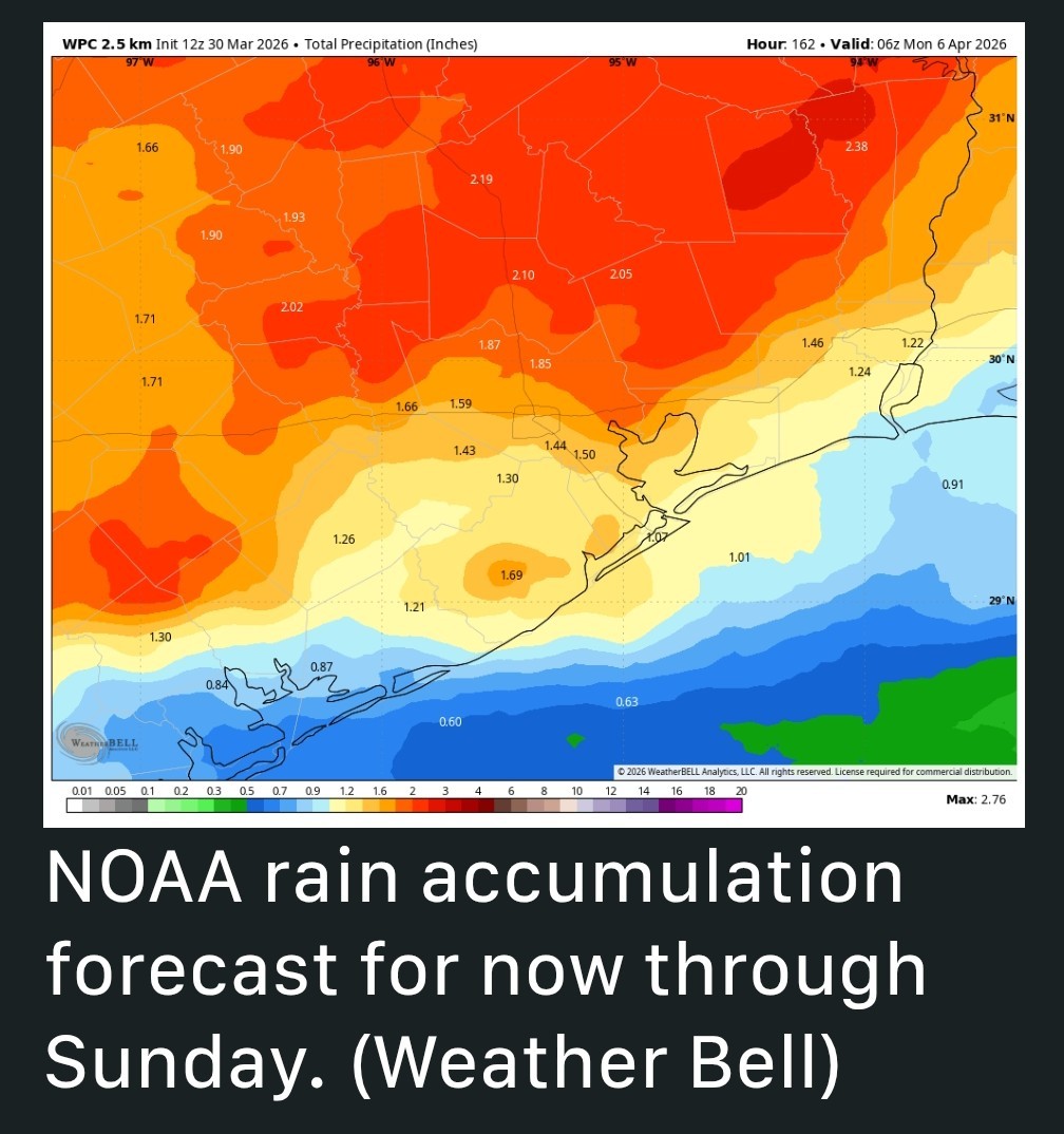 Bottom line? *It could be a soggy Easter Sunday.
*It could also just be mostly cloudy and cooler.
*It definitely will not be like yesterday, which turned out to be a fabulous Sunday weather-wise. Seriously, was it not just grand? 🌞 MONDAY 🌞 *Temperatures this morning are generally in the low to mid 60s.
*We are going to see a fairly robust onshore flow with winds gusting up to 20 mph from the south later today.
*With mostly sunny skies, I expect high temperatures this afternoon to reach the mid 80s.
*Lows tonight will only drop into the upper 60s, with partly cloudy skies. TUESDAY 🌥 *This will be another warm and humid day, with partly sunny skies and high temperatures in the mid-80s.
*We can again expect gusty, southerly winds.
*There will be a slight chance of rain, perhaps 10 or 20 percent, and if any rain does fall it likely will be very light in nature.
*Lows on Tuesday night will again be unseasonably warm. 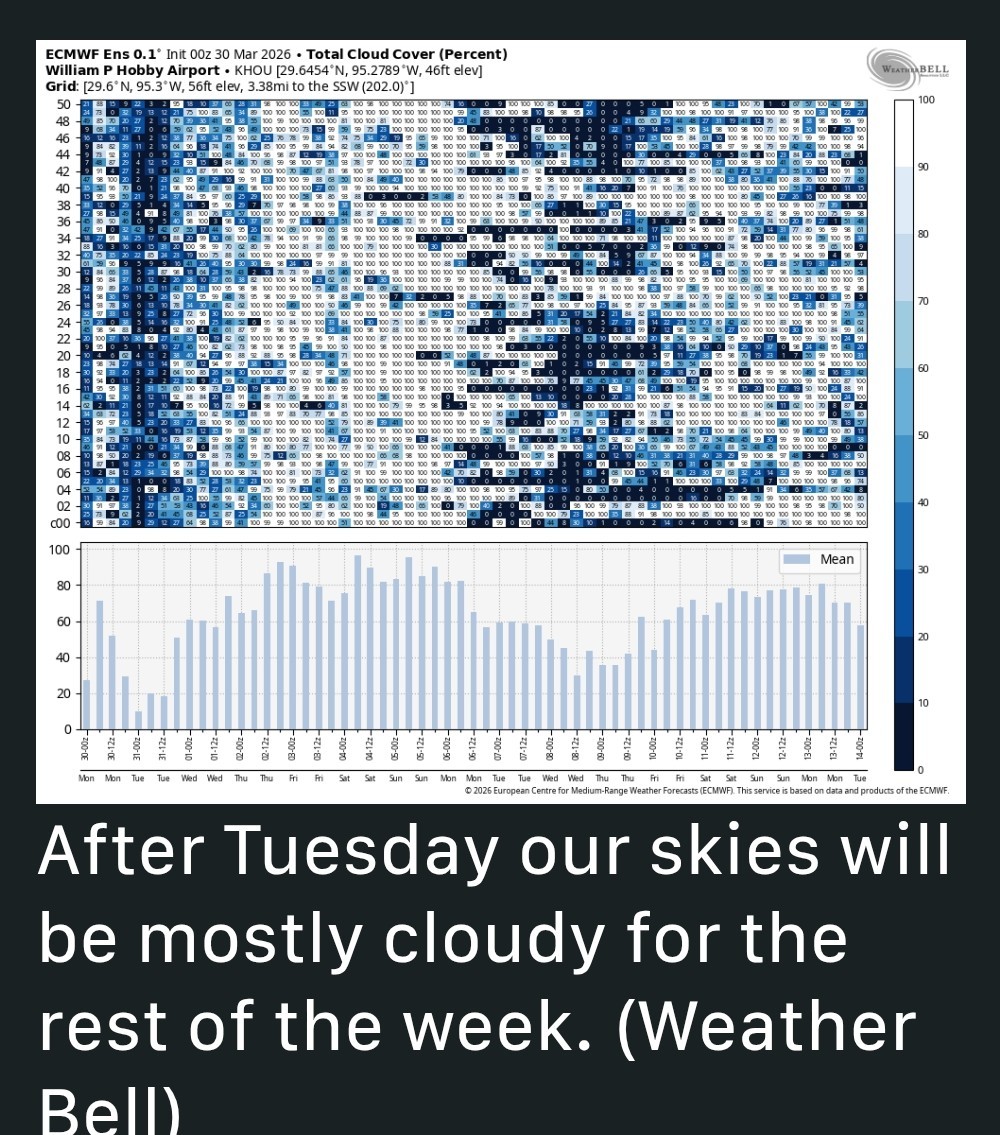 WEDNESDAY and THURSDAY 🌧☔️🌥 *As atmospheric moisture levels increase this week we will see a corresponding increase in cloud cover.
*That's not to say we won't see some sunshine for the rest of the week, but in most cases it will be the exception rather than the rule.
*Highs on both of these days will be in the vicinity of the low 80s.
*There will be some healthy rain chances, probably 30 to 60 percent each days.
*Overall dynamics are probably better for areas inland of Interstate 10, but most of the area has a decent shot at some showers.
*Accumulations for both days will be on the order perhaps a tenth of an inch of rain to a few tenths of an inch, with wide variations.
*Nights remain warm and muggy. FRIDAY 🌥 *Rain chances fall back a bit on Friday.
*With a bit more sunshine, we may see highs reach the mid-80s.
*Expect another warm night. SATURDAYS and SUNDAY 🌧⚡️ Alright, under the assumption that all of this could change somewhat due to timing, here's what I expect to to happen: *Saturday is likely to see continued, somewhat humid weather with high temperatures around 80 degrees.
*Light, scattered showers will be possible during the daytime with cloudy skies.
*At some point, perhaps during the evening, perhaps around midnight, or perhaps shortly after, a line of showers and possibly thunderstorms (it's too early to really have a good sense of whether there will be any severe weather) will move through with the front.
*That may bring some briefly heavy rain. 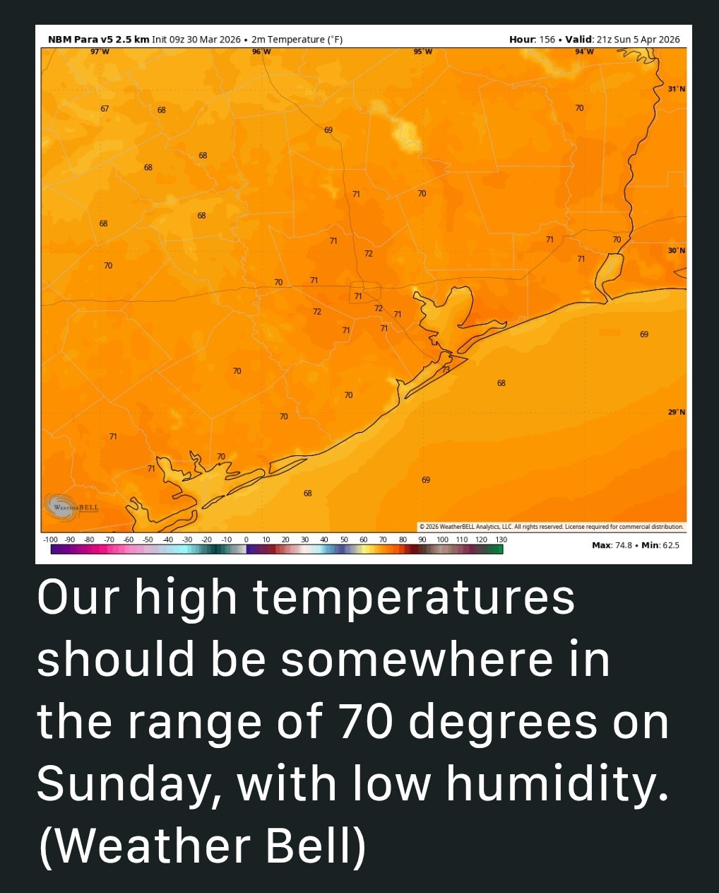 *By Sunday morning, most likely, this will have moved through.
*Most likely showers will end at that time, but cloud cover will linger throughout Sunday, and the potential for some showers may as well.
(We shall see)
*Highs on Easter Sunday will reach the upper 60s to around 70 degrees.
*Winds don't look too wild after the front, maybe just 10 to 15 mph from the north.
*Humidity will be noticeably lower.
*Skies should clear out some overnight, allowing lows to drop into the 50 to 55 degree range. NEXT WEEK 🌞 *Our cooler temperatures should persist at least for a few days next week, with highs in the 70s and lows in the 50s. It should feel fairly spring-like! 🌷🌷🌷


peppermintstick, Joe and cbear + 4 more reacted *As we discussed on Friday, parts of the Houston area have already reached "extreme" drought status, and more will follow without significant rainfall soon.
*High pressure has been dominant of late, but that should change this week, allowing for somewhat increased rain chances on Wednesday and Thursday.
*Our best chances will come this weekend, with the passage of a decently strong front.
*This may bring 0.5 to 1.5 inch into the area.
*It could also just be mostly cloudy and cooler.
*It definitely will not be like yesterday, which turned out to be a fabulous Sunday weather-wise.
*We are going to see a fairly robust onshore flow with winds gusting up to 20 mph from the south later today.
*With mostly sunny skies, I expect high temperatures this afternoon to reach the mid 80s.
*Lows tonight will only drop into the upper 60s, with partly cloudy skies.
*We can again expect gusty, southerly winds.
*There will be a slight chance of rain, perhaps 10 or 20 percent, and if any rain does fall it likely will be very light in nature.
*Lows on Tuesday night will again be unseasonably warm.
*That's not to say we won't see some sunshine for the rest of the week, but in most cases it will be the exception rather than the rule.
*Highs on both of these days will be in the vicinity of the low 80s.
*There will be some healthy rain chances, probably 30 to 60 percent each days.
*Overall dynamics are probably better for areas inland of Interstate 10, but most of the area has a decent shot at some showers.
*Accumulations for both days will be on the order perhaps a tenth of an inch of rain to a few tenths of an inch, with wide variations.
*Nights remain warm and muggy.
*With a bit more sunshine, we may see highs reach the mid-80s.
*Expect another warm night.
*Light, scattered showers will be possible during the daytime with cloudy skies.
*At some point, perhaps during the evening, perhaps around midnight, or perhaps shortly after, a line of showers and possibly thunderstorms (it's too early to really have a good sense of whether there will be any severe weather) will move through with the front.
*That may bring some briefly heavy rain.
*Most likely showers will end at that time, but cloud cover will linger throughout Sunday, and the potential for some showers may as well.
(We shall see)
*Highs on Easter Sunday will reach the upper 60s to around 70 degrees.
*Winds don't look too wild after the front, maybe just 10 to 15 mph from the north.
*Humidity will be noticeably lower.
*Skies should clear out some overnight, allowing lows to drop into the 50 to 55 degree range.
Replies:
This week's forecast After weeks of no rain, are we really going to get a soggy Easter Sunday? ☔️🐣🐰 Eric Berger · Monday, March 30, 2026 6:50 AM In brief: In today's forecast we note that Houston's last measurable rainfall occurred nearly three weeks ago for most of the region - That almost certainly will end this week, with the threat of some showers lingering into Easter Sunday. Easter Sunday 🐣🐰 *For most of Houston, our last measurable rainfall came on March 11, and it is unlikely to rain for another day or two at least. *As we discussed on Friday, parts of the Houston area have already reached "extreme" drought status, and more will follow without significant rainfall soon. *High pressure has been dominant of late, but that should change this week, allowing for somewhat increased rain chances on Wednesday and Thursday. *Our best chances will come this weekend, with the passage of a decently strong front. *This may bring 0.5 to 1.5 inch into the area. But when will it fall? That will depend on the timing of the front. *Right now I'd guess sometime on Saturday night, yet even if that's the case we could see showers lingering into Easter Sunday morning. Bottom line? *It could be a soggy Easter Sunday. *It could also just be mostly cloudy and cooler. *It definitely will not be like yesterday, which turned out to be a fabulous Sunday weather-wise. Seriously, was it not just grand? 🌞 MONDAY 🌞 *Temperatures this morning are generally in the low to mid 60s. *We are going to see a fairly robust onshore flow with winds gusting up to 20 mph from the south later today. *With mostly sunny skies, I expect high temperatures this afternoon to reach the mid 80s. *Lows tonight will only drop into the upper 60s, with partly cloudy skies. TUESDAY 🌥 *This will be another warm and humid day, with partly sunny skies and high temperatures in the mid-80s. *We can again expect gusty, southerly winds. *There will be a slight chance of rain, perhaps 10 or 20 percent, and if any rain does fall it likely will be very light in nature. *Lows on Tuesday night will again be unseasonably warm. WEDNESDAY and THURSDAY 🌧☔️🌥 *As atmospheric moisture levels increase this week we will see a corresponding increase in cloud cover. *That's not to say we won't see some sunshine for the rest of the week, but in most cases it will be the exception rather than the rule. *Highs on both of these days will be in the vicinity of the low 80s. *There will be some healthy rain chances, probably 30 to 60 percent each days. *Overall dynamics are probably better for areas inland of Interstate 10, but most of the area has a decent shot at some showers. *Accumulations for both days will be on the order perhaps a tenth of an inch of rain to a few tenths of an inch, with wide variations. *Nights remain warm and muggy. FRIDAY 🌥 *Rain chances fall back a bit on Friday. *With a bit more sunshine, we may see highs reach the mid-80s. *Expect another warm night. SATURDAYS and SUNDAY 🌧⚡️ Alright, under the assumption that all of this could change somewhat due to timing, here's what I expect to to happen: *Saturday is likely to see continued, somewhat humid weather with high temperatures around 80 degrees. *Light, scattered showers will be possible during the daytime with cloudy skies. *At some point, perhaps during the evening, perhaps around midnight, or perhaps shortly after, a line of showers and possibly thunderstorms (it's too early to really have a good sense of whether there will be any severe weather) will move through with the front. *That may bring some briefly heavy rain. *By Sunday morning, most likely, this will have moved through. *Most likely showers will end at that time, but cloud cover will linger throughout Sunday, and the potential for some showers may as well. (We shall see) *Highs on Easter Sunday will reach the upper 60s to around 70 degrees. *Winds don't look too wild after the front, maybe just 10 to 15 mph from the north. *Humidity will be noticeably lower. *Skies should clear out some overnight, allowing lows to drop into the 50 to 55 degree range. NEXT WEEK 🌞 *Our cooler temperatures should persist at least for a few days next week, with highs in the 70s and lows in the 50s. It should feel fairly spring-like! 🌷🌷🌷
@StormChaser :
I just don't want a downpour on Thursday. I have to take a senior to an appointment.
cbear and golfshot reacted I just don't want a downpour on Thursday. I have to take a senior to an appointment.

@StormChaser :
Thank you for the updates and sharing the forecast. I'll be looking forward to some rain and cooler temps coming up.
Thank you for the updates and sharing the forecast. I'll be looking forward to some rain and cooler temps coming up.
This week's forecast After weeks of no rain, are we really going to get a soggy Easter Sunday? ☔️🐣🐰 Eric Berger · Monday, March 30, 2026 6:50 AM In brief: In today's forecast we note that Houston's last measurable rainfall occurred nearly three weeks ago for most of the region - That almost certainly will end this week, with the threat of some showers lingering into Easter Sunday. Easter Sunday 🐣🐰 *For most of Houston, our last measurable rainfall came on March 11, and it is unlikely to rain for another day or two at least. *As we discussed on Friday, parts of the Houston area have already reached "extreme" drought status, and more will follow without significant rainfall soon. *High pressure has been dominant of late, but that should change this week, allowing for somewhat increased rain chances on Wednesday and Thursday. *Our best chances will come this weekend, with the passage of a decently strong front. *This may bring 0.5 to 1.5 inch into the area. But when will it fall? That will depend on the timing of the front. *Right now I'd guess sometime on Saturday night, yet even if that's the case we could see showers lingering into Easter Sunday morning. Bottom line? *It could be a soggy Easter Sunday. *It could also just be mostly cloudy and cooler. *It definitely will not be like yesterday, which turned out to be a fabulous Sunday weather-wise. Seriously, was it not just grand? 🌞 MONDAY 🌞 *Temperatures this morning are generally in the low to mid 60s. *We are going to see a fairly robust onshore flow with winds gusting up to 20 mph from the south later today. *With mostly sunny skies, I expect high temperatures this afternoon to reach the mid 80s. *Lows tonight will only drop into the upper 60s, with partly cloudy skies. TUESDAY 🌥 *This will be another warm and humid day, with partly sunny skies and high temperatures in the mid-80s. *We can again expect gusty, southerly winds. *There will be a slight chance of rain, perhaps 10 or 20 percent, and if any rain does fall it likely will be very light in nature. *Lows on Tuesday night will again be unseasonably warm. WEDNESDAY and THURSDAY 🌧☔️🌥 *As atmospheric moisture levels increase this week we will see a corresponding increase in cloud cover. *That's not to say we won't see some sunshine for the rest of the week, but in most cases it will be the exception rather than the rule. *Highs on both of these days will be in the vicinity of the low 80s. *There will be some healthy rain chances, probably 30 to 60 percent each days. *Overall dynamics are probably better for areas inland of Interstate 10, but most of the area has a decent shot at some showers. *Accumulations for both days will be on the order perhaps a tenth of an inch of rain to a few tenths of an inch, with wide variations. *Nights remain warm and muggy. FRIDAY 🌥 *Rain chances fall back a bit on Friday. *With a bit more sunshine, we may see highs reach the mid-80s. *Expect another warm night. SATURDAYS and SUNDAY 🌧⚡️ Alright, under the assumption that all of this could change somewhat due to timing, here's what I expect to to happen: *Saturday is likely to see continued, somewhat humid weather with high temperatures around 80 degrees. *Light, scattered showers will be possible during the daytime with cloudy skies. *At some point, perhaps during the evening, perhaps around midnight, or perhaps shortly after, a line of showers and possibly thunderstorms (it's too early to really have a good sense of whether there will be any severe weather) will move through with the front. *That may bring some briefly heavy rain. *By Sunday morning, most likely, this will have moved through. *Most likely showers will end at that time, but cloud cover will linger throughout Sunday, and the potential for some showers may as well. (We shall see) *Highs on Easter Sunday will reach the upper 60s to around 70 degrees. *Winds don't look too wild after the front, maybe just 10 to 15 mph from the north. *Humidity will be noticeably lower. *Skies should clear out some overnight, allowing lows to drop into the 50 to 55 degree range. NEXT WEEK 🌞 *Our cooler temperatures should persist at least for a few days next week, with highs in the 70s and lows in the 50s. It should feel fairly spring-like! 🌷🌷🌷
@ForestFinds :
I heard on the news this morning that 85% of Texas is under a drought 23% is extreme. People, get out there dance, wash your car...whatever you gotta do!!
@cbear :
I know we need rain. It is just difficult to get a senior with a walker to appointments when raining. I do not have a handicapped card so I am unable to park close.
cbear reacted I know we need rain. It is just difficult to get a senior with a walker to appointments when raining. I do not have a handicapped card so I am unable to park close.
cbear : I know we need rain. It is just difficult to get a senior with a walker to appointments when raining. I do not have a handicapped card so I am unable to park close.
cbear : I know we need rain. It is just difficult to get a senior with a walker to appointments when raining. I do not have a handicapped card so I am unable to park close.
@StormChaser :
Thanks for the forecast. Looking forward to rain and some cooler temperatures.
cbear reacted Thanks for the forecast. Looking forward to rain and some cooler temperatures.
StormChaser : Hopefully it will finally wash all of the pine pollen away.
« Back to Chat
Views: 235
# Replies: 10