


Space City forecast - Wednesday
Space City forecast - Wednesday


Joined:
X days ago
# Posts:
X,XXX
Contributor Points:
X


Space City forecast - Wednesday What to expect from potential stormy weather today, and when to expect it. Eric Berger · Wednesday, March 11, 2026 7:05 AM In brief: *Houston can expect to see fairly widespread showers and thunderstorms this afternoon, some of them becoming severe.
*It will be an afternoon to be weather aware across the region.
*Tonight very breezy conditions arrive as a cold front blows in to cool us down for the remainder of the week. 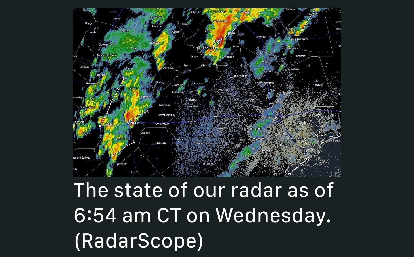 Wednesday's storms - *If you largely missed out on rain this past weekend an approaching cold front will offer another chance today as showers and thunderstorms fire up ahead of the front.
*Houston already is seeing some sporadic activity during the pre-dawn hours, and a cluster of storms is presently affecting the College Station area. ➡️ Metro-area activity should increase in coverage later this morning as the system moves in from the west, and Houston should see fairly widespread showers and thunderstorms from around noon to 6 pm.
➡️ There is the potential for heavy rainfall, however the storms will be moving at a decent clip.
➡️ So for most locations I expect accumulations of 1 inch of rain, or less (with some locations only seeing a smattering of rain).
➡️ A few places, of course, may very well see higher bullseyes of rainfall. 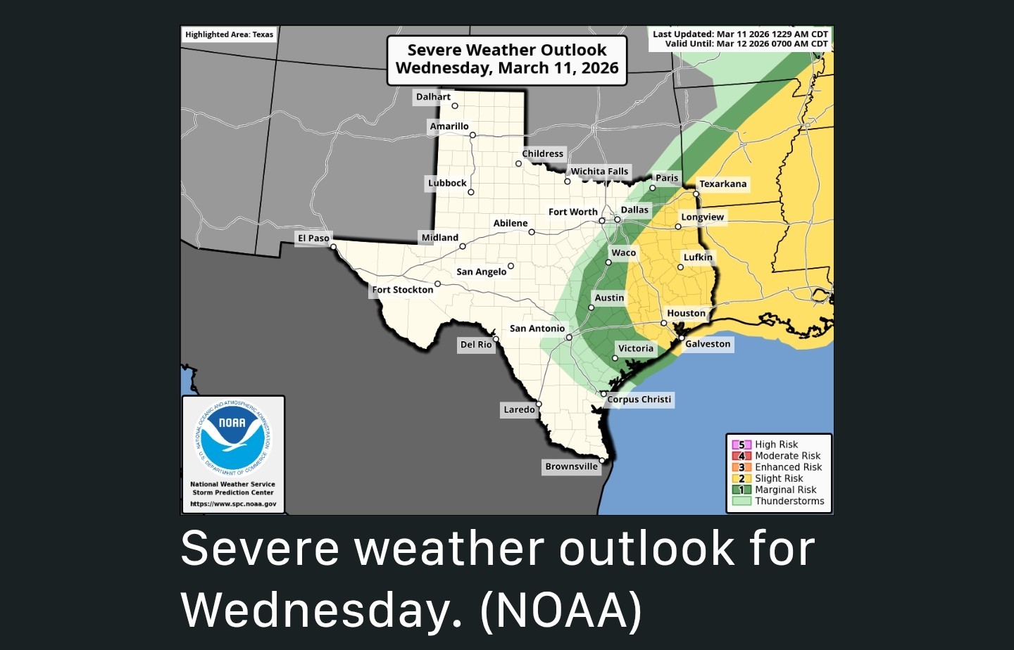 ➡️ Notably, there is also the threat of severe weather with some of these storms.
➡️ Although conditions will be most favorable along and north of Interstate 10, we cannot rule out damaging winds, hail, and possibly even a tornado throughout the Houston area today.
➡️ Please be weather aware this afternoon if you are out and about, and check the radar before hitting the road.
➡️ Not everyone will see inclement weather, but where severe thunderstorms do develop conditions could deteriorate quickly.
➡️ The majority of storms should have exited the area by or before sunset. WEDNESDAY ⚡️ *Aside from the potential for storms, the other notable feature about today's weather is the temperatures.
*Lows this morning have only fallen into the mid-70s for much of the region, which is very warm.
*Highs today, with mostly cloudy skies, will reach around 80 degrees with plenty of humidity.
*As noted above, storm activity will increase in coverage this afternoon. Tonight's Houston rodeo forecast 🤠 *There is the potential for storms in the Houston metro area, including near NRG Stadium, this afternoon.
*By around 6pm, I do expect them to be clearing out. That's not the end of things, however, as we will see gusty winds from the north later this evening.
*By around 9 or 10 pm winds should increase further in intensity, perhaps up to 35 mph. You probably will feel this after the show as colder and much drier air moves in.
*These winds will blow all night, bringing temperatures down into the low 50s by Thursday morning.


golfshot, AggieBandMom and CatalinaKitKat reacted *It will be an afternoon to be weather aware across the region.
*Tonight very breezy conditions arrive as a cold front blows in to cool us down for the remainder of the week.
*Houston already is seeing some sporadic activity during the pre-dawn hours, and a cluster of storms is presently affecting the College Station area.
➡️ There is the potential for heavy rainfall, however the storms will be moving at a decent clip.
➡️ So for most locations I expect accumulations of 1 inch of rain, or less (with some locations only seeing a smattering of rain).
➡️ A few places, of course, may very well see higher bullseyes of rainfall.
➡️ Although conditions will be most favorable along and north of Interstate 10, we cannot rule out damaging winds, hail, and possibly even a tornado throughout the Houston area today.
➡️ Please be weather aware this afternoon if you are out and about, and check the radar before hitting the road.
➡️ Not everyone will see inclement weather, but where severe thunderstorms do develop conditions could deteriorate quickly.
➡️ The majority of storms should have exited the area by or before sunset.
*Lows this morning have only fallen into the mid-70s for much of the region, which is very warm.
*Highs today, with mostly cloudy skies, will reach around 80 degrees with plenty of humidity.
*As noted above, storm activity will increase in coverage this afternoon.
*By around 6pm, I do expect them to be clearing out. That's not the end of things, however, as we will see gusty winds from the north later this evening.
*By around 9 or 10 pm winds should increase further in intensity, perhaps up to 35 mph. You probably will feel this after the show as colder and much drier air moves in.
*These winds will blow all night, bringing temperatures down into the low 50s by Thursday morning.
Replies:

|
Space City seems pretty confident in storm activity between noon & 6pm. Hail, damaging winds, heavy rainfall, frequent lightning & a couple tornadoes are all possible. Please stay weather aware. I'll update with watches and warnings as needed.
golfshot and AggieBandMom reacted
|
|
 StormChaser :
 Thank you for the update and sharing all of this info. I hope everyone stays dry and safe out there, and I'll be looking forward to the cooler temps and some sunshine again when this all clears out.
Space City forecast - Wednesday What to expect from potential stormy weather today, and when to expect it. Eric Berger · Wednesday, March 11, 2026 7:05 AM In brief: *Houston can expect to see fairly widespread showers and thunderstorms this afternoon, some of them becoming severe.
*It will be an afternoon to be weather aware across the region.
*Tonight very breezy conditions arrive as a cold front blows in to cool us down for the remainder of the week. Wednesday's storms - *If you largely missed out on rain this past weekend an approaching cold front will offer another chance today as showers and thunderstorms fire up ahead of the front.
*Houston already is seeing some sporadic activity during the pre-dawn hours, and a cluster of storms is presently affecting the College Station area. ➡️ Metro-area activity should increase in coverage later this morning as the system moves in from the west, and Houston should see fairly widespread showers and thunderstorms from around noon to 6 pm.
➡️ There is the potential for heavy rainfall, however the storms will be moving at a decent clip.
➡️ So for most locations I expect accumulations of 1 inch of rain, or less (with some locations only seeing a smattering of rain).
➡️ A few places, of course, may very well see higher bullseyes of rainfall. ➡️ Notably, there is also the threat of severe weather with some of these storms.
➡️ Although conditions will be most favorable along and north of Interstate 10, we cannot rule out damaging winds, hail, and possibly even a tornado throughout the Houston area today.
➡️ Please be weather aware this afternoon if you are out and about, and check the radar before hitting the road.
➡️ Not everyone will see inclement weather, but where severe thunderstorms do develop conditions could deteriorate quickly.
➡️ The majority of storms should have exited the area by or before sunset. WEDNESDAY ⚡️ *Aside from the potential for storms, the other notable feature about today's weather is the temperatures.
*Lows this morning have only fallen into the mid-70s for much of the region, which is very warm.
*Highs today, with mostly cloudy skies, will reach around 80 degrees with plenty of humidity.
*As noted above, storm activity will increase in coverage this afternoon. Tonight's Houston rodeo forecast ? *There is the potential for storms in the Houston metro area, including near NRG Stadium, this afternoon.
*By around 6pm, I do expect them to be clearing out. That's not the end of things, however, as we will see gusty winds from the north later this evening.
*By around 9 or 10 pm winds should increase further in intensity, perhaps up to 35 mph. You probably will feel this after the show as colder and much drier air moves in.
*These winds will blow all night, bringing temperatures down into the low 50s by Thursday morning.
*It will be an afternoon to be weather aware across the region.
*Tonight very breezy conditions arrive as a cold front blows in to cool us down for the remainder of the week.
*Houston already is seeing some sporadic activity during the pre-dawn hours, and a cluster of storms is presently affecting the College Station area.
➡️ There is the potential for heavy rainfall, however the storms will be moving at a decent clip.
➡️ So for most locations I expect accumulations of 1 inch of rain, or less (with some locations only seeing a smattering of rain).
➡️ A few places, of course, may very well see higher bullseyes of rainfall.
➡️ Although conditions will be most favorable along and north of Interstate 10, we cannot rule out damaging winds, hail, and possibly even a tornado throughout the Houston area today.
➡️ Please be weather aware this afternoon if you are out and about, and check the radar before hitting the road.
➡️ Not everyone will see inclement weather, but where severe thunderstorms do develop conditions could deteriorate quickly.
➡️ The majority of storms should have exited the area by or before sunset.
*Lows this morning have only fallen into the mid-70s for much of the region, which is very warm.
*Highs today, with mostly cloudy skies, will reach around 80 degrees with plenty of humidity.
*As noted above, storm activity will increase in coverage this afternoon.
*By around 6pm, I do expect them to be clearing out. That's not the end of things, however, as we will see gusty winds from the north later this evening.
*By around 9 or 10 pm winds should increase further in intensity, perhaps up to 35 mph. You probably will feel this after the show as colder and much drier air moves in.
*These winds will blow all night, bringing temperatures down into the low 50s by Thursday morning.
 golfshot tipped StormChaser 100 credits for a post in this forum discussion.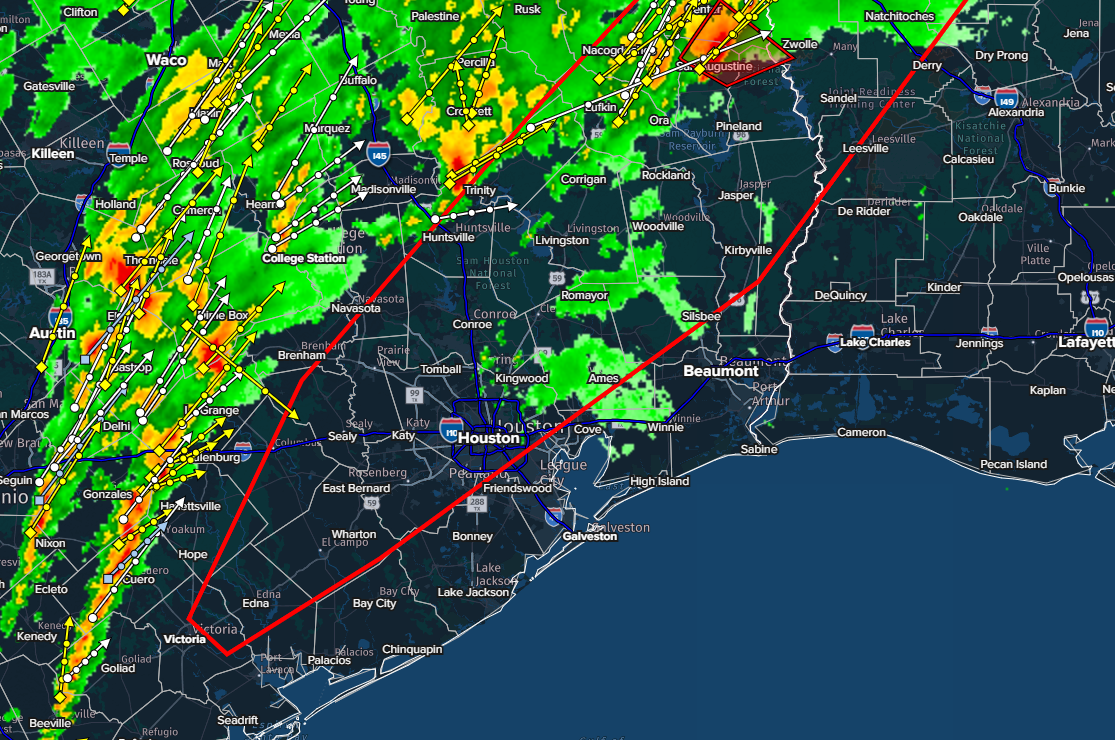
« Back to Chat
Views: 247
# Replies: 4