


Next arctic front
Next arctic front


Joined:
X days ago
# Posts:
X,XXX
Contributor Points:
X


Next arctic front Our next arctic front arrives Friday. Thankfully, we won't have any moisture to deal with this time 🚫🧊 but low temperatures will drop back down into the 20s for the weekend. Next week, we have increased rain chances, which we desperately need. 💦 ........... From Space City Weather: Houston to warm up for a few days before another sharp cooldown this weekend. Eric Berger · Tuesday, January 27, 2026 6:59 AM In brief: *After our coldest weather in nearly a year this morning, the region will thaw out and warm up today with plenty of sunshine.
*We will then have a few milder days before another strong front arrives Thursday night.
*By Sunday morning, we could see temperatures nearly as cold as this morning, although we have NO wintry precipitation concerns with this round. 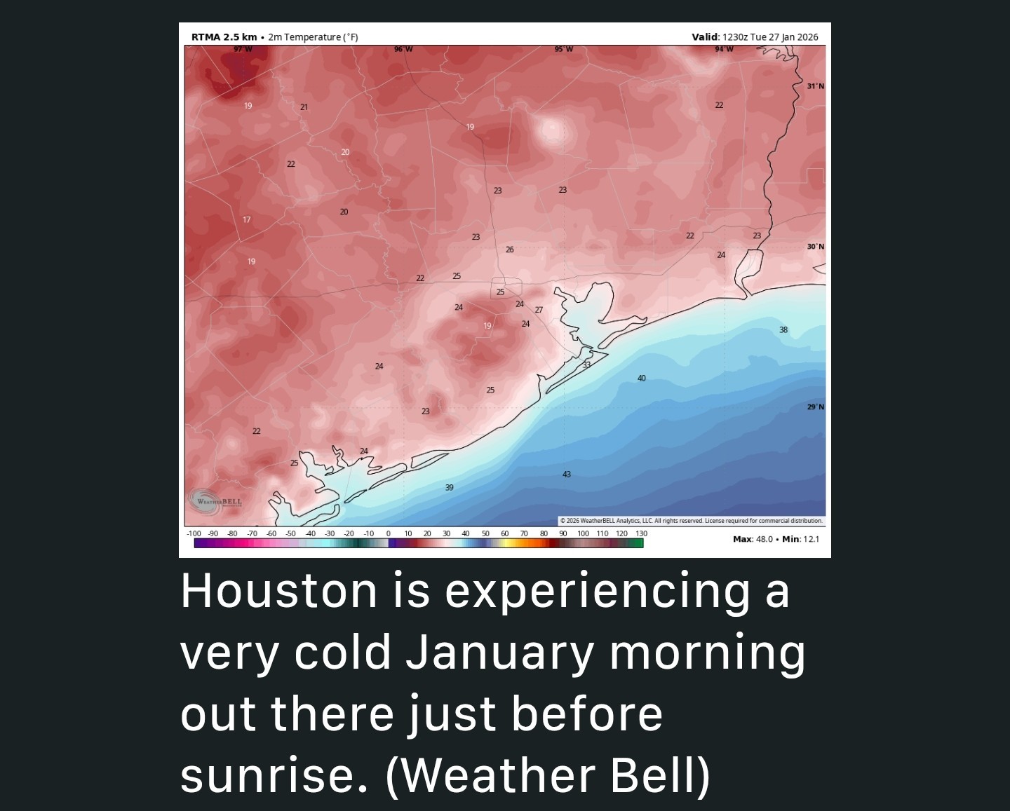 Cold status - *We are at the tail end of impacts from this past weekend's Arctic front, but paradoxically we are also seeing the coldest temperatures of the event. *Temps this Tuesday AM are ranging from 18 degrees in Conroe to the low to mid 20s across much of the Houston region.
*We've waited this long for the coldest air because skies finally cleared last night, and winds died down to nearly zero - This created ideal conditions for cooling temperatures.
*However, we also will see a fairly quick rebound in conditions today, with sunny skies leading to highs of around 50 degrees. 🌞 TUESDAY (TODAY) - *We are going to see calm winds all day, to go along with our sunny skies.
*Accordingly, conditions will feel quite a bit warmer this afternoon.
*Lows tonight will drop to around freezing in the metro area, probably just at or above 32 degrees along and south of Interstate 10, and a degree or two below inland of the freeway.
*Regardless, after mid morning today, the threat of a hard freeze will have passed....for a few days. Wednesday and Thursday - These will be warmer days. *Wednesday should be mostly sunny, with highs in the upper 50s and light winds.
*Wednesday night will be cold, in the 30s, but likely above freezing.
*Thursday will see highs all the way in the low to mid 60s but with building cloud cover.
*By Thursday evening, or early Friday, another strong front will surge into the area.
*You'll notice this with gusty northerly winds.
*Fortunately, this looks like a dry frontal passage, so we don't have many concerns about a wintry mix.
*Even if there are a few passing showers, temperatures will be warm enough to preclude a freezing mix.
*Lows on Thursday night will drop to around 40 degrees. 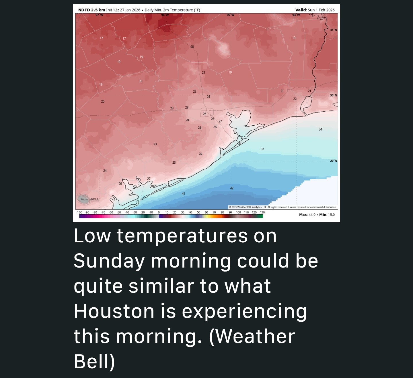 Friday, Saturday, and Sunday - *The weekend looks mostly sunny and cold.
*Highs on Friday will probably reach about 50 degrees but Saturday will be colder, perhaps only in the low 40s as cold air continues to advect into the area.
*Sunday may be slightly warmer. So what about nighttime temperatures? *Friday and Saturday night look to be the coldest.
*There's the potential for a hard freeze on Saturday night when we once again see ideal cooling conditions.
*Right now, I would predict lows between 25 and 30 degrees in urban Houston, with slightly cooler conditions for outlying areas. But we will see. Next week - *Monday should also be clear and chilly, but after this, a warmer and wetter pattern will take hold.
*I expect highs in the 60s next week, with a healthy chance of rain showers from later on Tuesday through Thursday.
*Details are to be determined, but additional rain to help with the region's drought would not be unwelcome.


ZMAN, Aggie89 and Kittle + 10 more reacted *We will then have a few milder days before another strong front arrives Thursday night.
*By Sunday morning, we could see temperatures nearly as cold as this morning, although we have NO wintry precipitation concerns with this round.
*We've waited this long for the coldest air because skies finally cleared last night, and winds died down to nearly zero - This created ideal conditions for cooling temperatures.
*However, we also will see a fairly quick rebound in conditions today, with sunny skies leading to highs of around 50 degrees. 🌞
*Accordingly, conditions will feel quite a bit warmer this afternoon.
*Lows tonight will drop to around freezing in the metro area, probably just at or above 32 degrees along and south of Interstate 10, and a degree or two below inland of the freeway.
*Regardless, after mid morning today, the threat of a hard freeze will have passed....for a few days.
*Wednesday night will be cold, in the 30s, but likely above freezing.
*Thursday will see highs all the way in the low to mid 60s but with building cloud cover.
*By Thursday evening, or early Friday, another strong front will surge into the area.
*You'll notice this with gusty northerly winds.
*Fortunately, this looks like a dry frontal passage, so we don't have many concerns about a wintry mix.
*Even if there are a few passing showers, temperatures will be warm enough to preclude a freezing mix.
*Lows on Thursday night will drop to around 40 degrees.
*Highs on Friday will probably reach about 50 degrees but Saturday will be colder, perhaps only in the low 40s as cold air continues to advect into the area.
*Sunday may be slightly warmer.
*There's the potential for a hard freeze on Saturday night when we once again see ideal cooling conditions.
*Right now, I would predict lows between 25 and 30 degrees in urban Houston, with slightly cooler conditions for outlying areas.
*I expect highs in the 60s next week, with a healthy chance of rain showers from later on Tuesday through Thursday.
*Details are to be determined, but additional rain to help with the region's drought would not be unwelcome.
Replies:

|

Next arctic front Our next arctic front arrives Friday. Thankfully, we won't have any moisture to deal with this time 🚫🧊 but low temperatures will drop back down into the 20s for the weekend. Next week, we have increased rain chances, which we desperately need. 💦 ........... From Space City Weather: Houston to warm up for a few days before another sharp cooldown this weekend. Eric Berger · Tuesday, January 27, 2026 6:59 AM In brief: *After our coldest weather in nearly a year this morning, the region will thaw out and warm up today with plenty of sunshine. *We will then have a few milder days before another strong front arrives Thursday night. *By Sunday morning, we could see temperatures nearly as cold as this morning, although we have NO wintry precipitation concerns with this round. Cold status - *We are at the tail end of impacts from this past weekend's Arctic front, but paradoxically we are also seeing the coldest temperatures of the event. *Temps this Tuesday AM are ranging from 18 degrees in Conroe to the low to mid 20s across much of the Houston region. *We've waited this long for the coldest air because skies finally cleared last night, and winds died down to nearly zero - This created ideal conditions for cooling temperatures. *However, we also will see a fairly quick rebound in conditions today, with sunny skies leading to highs of around 50 degrees. 🌞 TUESDAY (TODAY) - *We are going to see calm winds all day, to go along with our sunny skies. *Accordingly, conditions will feel quite a bit warmer this afternoon. *Lows tonight will drop to around freezing in the metro area, probably just at or above 32 degrees along and south of Interstate 10, and a degree or two below inland of the freeway. *Regardless, after mid morning today, the threat of a hard freeze will have passed....for a few days. Wednesday and Thursday - These will be warmer days. *Wednesday should be mostly sunny, with highs in the upper 50s and light winds. *Wednesday night will be cold, in the 30s, but likely above freezing. *Thursday will see highs all the way in the low to mid 60s but with building cloud cover. *By Thursday evening, or early Friday, another strong front will surge into the area. *You'll notice this with gusty northerly winds. *Fortunately, this looks like a dry frontal passage, so we don't have many concerns about a wintry mix. *Even if there are a few passing showers, temperatures will be warm enough to preclude a freezing mix. *Lows on Thursday night will drop to around 40 degrees. Friday, Saturday, and Sunday - *The weekend looks mostly sunny and cold. *Highs on Friday will probably reach about 50 degrees but Saturday will be colder, perhaps only in the low 40s as cold air continues to advect into the area. *Sunday may be slightly warmer. So what about nighttime temperatures? *Friday and Saturday night look to be the coldest. *There's the potential for a hard freeze on Saturday night when we once again see ideal cooling conditions. *Right now, I would predict lows between 25 and 30 degrees in urban Houston, with slightly cooler conditions for outlying areas. But we will see. Next week - *Monday should also be clear and chilly, but after this, a warmer and wetter pattern will take hold. *I expect highs in the 60s next week, with a healthy chance of rain showers from later on Tuesday through Thursday. *Details are to be determined, but additional rain to help with the region's drought would not be unwelcome.
StormChaser : Hold on woman....let's get through this s**t first!!
|
|
StormChaser : Thanks! I saw the other day that snow was on the phone weather app for Saturday. I was really hoping for snow this year. lol. We're doing the car show, our yearly outing with DS/DIL. They pay for show and we pay for parking. With snow forecast, it was going to be vice versa since DS has better weather truck. lol. Now I guess I'm driving again.
Oooo hoping the cold puts so.e pep in my step for the early morning 5k on Saturday. No ice or snow please 😀
Kittle, Donnawisdom and golfshot + 4 more reacted
|
|
StormChaser : At least this one won't have any precipitation with it. I don't want to have to postpone my belated birthday plans again!
|
|
StormChaser : At least this one won't have any precipitation with it. I don't want to have to postpone my belated birthday plans again!
Weathergirl5 : And......you shouldn't have to friend!!
|
|
StormChaser : Thanks for all the info. I would actually like to opt out of this free 30 day trial for the Alaskan experience. I just don't think it's working out for me. It will be nice to see warmer temps resume next week/month. Lol
|
|
StormChaser : Thanks for all the info. I would actually like to opt out of this free 30 day trial for the Alaskan experience. I just don't think it's working out for me. It will be nice to see warmer temps resume next week/month. Lol
|
|
StormChaser @CatalinaKitKat : I like cooler weather but not this cold. I would like to see Alaska once but not live there.
|
|
peppermintstick : Yes I agree. Alaska looks beautiful and I would love to visit, but I know I wouldn't be able to make a home there.
|
|
StormChaser : I need some much warmer weather. Can you order that weather for me?
|
|
StormChaser : TV forecast are all over the place. What do you think: hard freeze or light freeze?
Kittle : This weekend? As of now, Space City is forecasting 25-30 degrees as our coldest temps. « Back to Chat
Views: 767
# Replies: 16