


Storms possible Friday night
Storms possible Friday night


Joined:
X days ago
# Posts:
X,XXX
Contributor Points:
X


Storms possible Friday night The cold front that arrives this Friday has the potential to give us some strong storms late Friday night (into Sat AM) I'm not 100% sold yet on the forecast yet (and nether is Space City) but I'll update on Friday. ➡️ Right now, all the models I follow show the greatest severe risk well off to our east, in the Dixie Alley area. 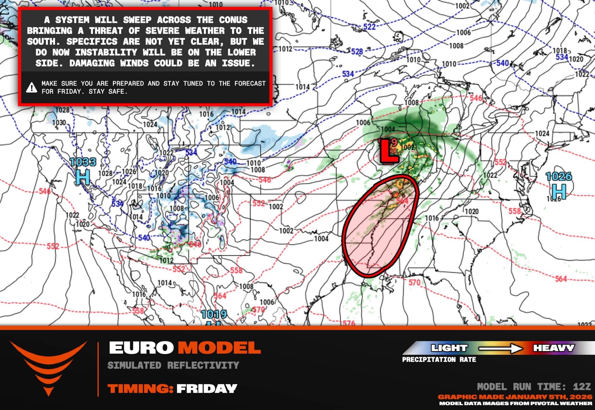 *Record temps continue.
*Storm chances (if we get them) would be late Friday night into early Saturday morning.
*Saturday is our transition day from record high temps to a typical January like setup in Houston.
*Winds will be gusty on Saturday (25+ mph) so keep that in mind as far as electricity goes. 💡
*Sunday (race 🏁 day) will start out in the mid 40s with cloudy conditions and highs in the upper 50s. (No rain is expected)
*Next week: Sunny skies with lows in the 40s & highs in the 60s each day. ............... From Space City Weather: Rain chances perk up a bit with Friday night's front Eric Berger · Wednesday, January 7, 2026 7:24 AM In brief: *In today's post, we discuss the possibility of thunderstorms on Friday/Friday night as a front pushes into the area.
*Following this front, winter should stick around Houston for awhile. WEDNESDAY - *We are once again seeing fog this morning, as dewpoints and temperatures have both fallen into the mid-60s.
*Soupy conditions will be with us into Friday before a front pushes through.
*After the fog clears we should have mostly sunny skies later today with highs around 80 degrees.
*Winds will be light, generally from the southwest.
*Lows tonight will again only drop into the 60s, with mostly cloudy skies. THURSDAY - *This will be a cloudy and humid day with highs ranging from the upper 70s to around 80 degrees for most locations.
*There will be a couple things of note. First of all winds will surge from the south in response to a nearby front, gusting up to 25 or perhaps even 30 mph. These winds will be highest on Thursday afternoon.
*We also will have a slight chance, perhaps 20 or 30 percent, of light rain during the afternoon and early evening hours.
*Thursday night will be warm and muggy again. 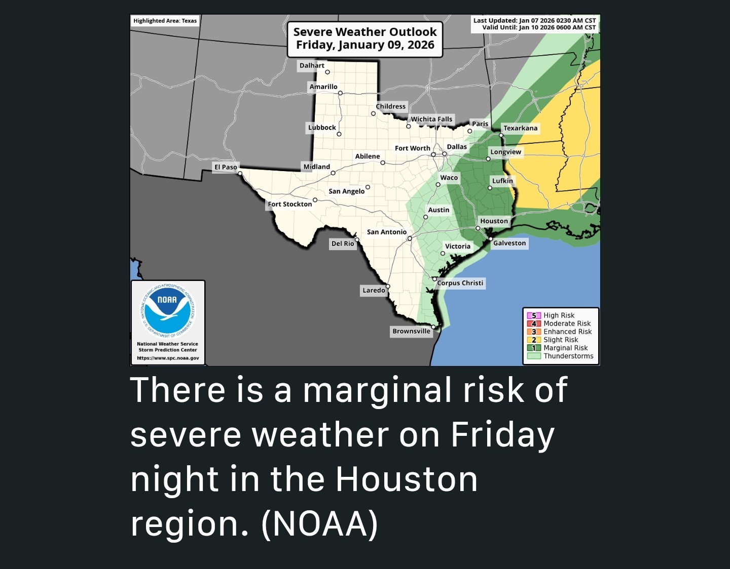 FRIDAY and FRIDAY NIGHT - *We can't say precisely what will happen Friday night but generally I expect a warm and humid day, similar to Thursday, with mostly cloudy skies.
➡️ There is a chance for severe weather Friday.
➡️ This is most likely to occur between late Friday evening and sunrise on Saturday as the front itself moves into the Houston region.
➡️ We could see some briefly heavier rainfall, frequent lightning & gusty winds.
➡️ Most of our modeling is all over the place on rainfall amounts but some locations could pick up 0.5 - 1" of rainfall whereas other locations see a hundredths of an inch. 🤷♀️ We all need some rain, so good luck everyone. 🤞🤞 SATURDAY - *This will be mostly cloudy and cooler day, with a few showers possibly lingering during the morning hours.
*The day will likely start out in the 60s for most locations before falling into the 50s by early morning and then staying there throughout the day.
*Skies will be mostly cloudy with modestly gusty northerly winds, perhaps up to 25 mph+ before ebbing during the late afternoon or early evening. SUNDAY - Sunday morning will be cold. 🏁🏁 Start line temperatures at the Houston Marathon should be in the mid 40s, with dry air and mostly cloudy skies.
*Winds will be from the north at 5 to 10 mph with slightly higher gusts.
*Rain chances are basically zero.
*Highs will likely climb into the upper 50s for most locations on Sunday afternoon.
*Sunday night will be chilly, with lows falling to around 40 degrees for most of Houston with cooler conditions for inland areas.
*A freeze is very unlikely however for Monday AM. NEXT WEEK - *Houston will feel like winter next week with highs generally in the 60s and lows mostly in the low to mid 40s for much of the week.
*Skies should be partly sunny most days with low rain chances. This pattern should prevail through the middle of January.


SummerSneeze, malpalface and Orangeapple + 13 more reacted *Storm chances (if we get them) would be late Friday night into early Saturday morning.
*Saturday is our transition day from record high temps to a typical January like setup in Houston.
*Winds will be gusty on Saturday (25+ mph) so keep that in mind as far as electricity goes. 💡
*Sunday (race 🏁 day) will start out in the mid 40s with cloudy conditions and highs in the upper 50s. (No rain is expected)
*Next week: Sunny skies with lows in the 40s & highs in the 60s each day.
*Following this front, winter should stick around Houston for awhile.
*Soupy conditions will be with us into Friday before a front pushes through.
*After the fog clears we should have mostly sunny skies later today with highs around 80 degrees.
*Winds will be light, generally from the southwest.
*Lows tonight will again only drop into the 60s, with mostly cloudy skies.
*There will be a couple things of note. First of all winds will surge from the south in response to a nearby front, gusting up to 25 or perhaps even 30 mph. These winds will be highest on Thursday afternoon.
*We also will have a slight chance, perhaps 20 or 30 percent, of light rain during the afternoon and early evening hours.
*Thursday night will be warm and muggy again.
➡️ There is a chance for severe weather Friday.
➡️ This is most likely to occur between late Friday evening and sunrise on Saturday as the front itself moves into the Houston region.
➡️ We could see some briefly heavier rainfall, frequent lightning & gusty winds.
➡️ Most of our modeling is all over the place on rainfall amounts but some locations could pick up 0.5 - 1" of rainfall whereas other locations see a hundredths of an inch. 🤷♀️
*The day will likely start out in the 60s for most locations before falling into the 50s by early morning and then staying there throughout the day.
*Skies will be mostly cloudy with modestly gusty northerly winds, perhaps up to 25 mph+ before ebbing during the late afternoon or early evening.
*Winds will be from the north at 5 to 10 mph with slightly higher gusts.
*Rain chances are basically zero.
*Highs will likely climb into the upper 50s for most locations on Sunday afternoon.
*Sunday night will be chilly, with lows falling to around 40 degrees for most of Houston with cooler conditions for inland areas.
*A freeze is very unlikely however for Monday AM.
*Skies should be partly sunny most days with low rain chances.
Replies:


|


Storms possible Friday night The cold front that arrives this Friday has the potential to give us some strong storms late Friday night (into Sat AM) I'm not 100% sold yet on the forecast yet (and nether is Space City) but I'll update on Friday. ➡️ Right now, all the models I follow show the greatest severe risk well off to our east, in the Dixie Alley area. *Record temps continue. *Storm chances (if we get them) would be late Friday night into early Saturday morning. *Saturday is our transition day from record high temps to a typical January like setup in Houston. *Winds will be gusty on Saturday (25+ mph) so keep that in mind as far as electricity goes. 💡 *Sunday (race 🏁 day) will start out in the mid 40s with cloudy conditions and highs in the upper 50s. (No rain is expected) *Next week: Sunny skies with lows in the 40s & highs in the 60s each day. ............... From Space City Weather: Rain chances perk up a bit with Friday night's front Eric Berger · Wednesday, January 7, 2026 7:24 AM In brief: *In today's post, we discuss the possibility of thunderstorms on Friday/Friday night as a front pushes into the area. *Following this front, winter should stick around Houston for awhile. WEDNESDAY - *We are once again seeing fog this morning, as dewpoints and temperatures have both fallen into the mid-60s. *Soupy conditions will be with us into Friday before a front pushes through. *After the fog clears we should have mostly sunny skies later today with highs around 80 degrees. *Winds will be light, generally from the southwest. *Lows tonight will again only drop into the 60s, with mostly cloudy skies. THURSDAY - *This will be a cloudy and humid day with highs ranging from the upper 70s to around 80 degrees for most locations. *There will be a couple things of note. First of all winds will surge from the south in response to a nearby front, gusting up to 25 or perhaps even 30 mph. These winds will be highest on Thursday afternoon. *We also will have a slight chance, perhaps 20 or 30 percent, of light rain during the afternoon and early evening hours. *Thursday night will be warm and muggy again. FRIDAY and FRIDAY NIGHT - *We can't say precisely what will happen Friday night but generally I expect a warm and humid day, similar to Thursday, with mostly cloudy skies. ➡️ There is a chance for severe weather Friday. ➡️ This is most likely to occur between late Friday evening and sunrise on Saturday as the front itself moves into the Houston region. ➡️ We could see some briefly heavier rainfall, frequent lightning & gusty winds. ➡️ Most of our modeling is all over the place on rainfall amounts but some locations could pick up 0.5 - 1" of rainfall whereas other locations see a hundredths of an inch. 🤷♀️ We all need some rain, so good luck everyone. 🤞🤞 SATURDAY - *This will be mostly cloudy and cooler day, with a few showers possibly lingering during the morning hours. *The day will likely start out in the 60s for most locations before falling into the 50s by early morning and then staying there throughout the day. *Skies will be mostly cloudy with modestly gusty northerly winds, perhaps up to 25 mph+ before ebbing during the late afternoon or early evening. SUNDAY - Sunday morning will be cold. 🏁🏁 Start line temperatures at the Houston Marathon should be in the mid 40s, with dry air and mostly cloudy skies. *Winds will be from the north at 5 to 10 mph with slightly higher gusts. *Rain chances are basically zero. *Highs will likely climb into the upper 50s for most locations on Sunday afternoon. *Sunday night will be chilly, with lows falling to around 40 degrees for most of Houston with cooler conditions for inland areas. *A freeze is very unlikely however for Monday AM. NEXT WEEK - *Houston will feel like winter next week with highs geenerally in the 60s and lows mostly in the low to mid 40s for much of the week. *Skies should be partly sunny most days with low rain chances. This pattern should prevail through the middle of January.
StormChaser : Thanks for the forecast! I hope we do get a little rain.
|
|
StormChaser : Thank you for the updates on the forecast, they are always helpful. We could definitely use some rain, but I don't care for the continued roller coaster weather. If it would just make up its mind and stay either warm or cold, I would be so glad. Lol
|
|
If it would just make up its mind and stay either warm or cold, I would be so glad. Lol
Storms possible Friday night The cold front that arrives this Friday has the potential to give us some strong storms late Friday night (into Sat AM) I'm not 100% sold yet on the forecast yet (and nether is Space City) but I'll update on Friday. ➡️ Right now, all the models I follow show the greatest severe risk well off to our east, in the Dixie Alley area. *Record temps continue. *Storm chances (if we get them) would be late Friday night into early Saturday morning. *Saturday is our transition day from record high temps to a typical January like setup in Houston. *Winds will be gusty on Saturday (25+ mph) so keep that in mind as far as electricity goes. 💡 *Sunday (race 🏁 day) will start out in the mid 40s with cloudy conditions and highs in the upper 50s. (No rain is expected) *Next week: Sunny skies with lows in the 40s & highs in the 60s each day. ............... From Space City Weather: Rain chances perk up a bit with Friday night's front Eric Berger · Wednesday, January 7, 2026 7:24 AM In brief: *In today's post, we discuss the possibility of thunderstorms on Friday/Friday night as a front pushes into the area. *Following this front, winter should stick around Houston for awhile. WEDNESDAY - *We are once again seeing fog this morning, as dewpoints and temperatures have both fallen into the mid-60s. *Soupy conditions will be with us into Friday before a front pushes through. *After the fog clears we should have mostly sunny skies later today with highs around 80 degrees. *Winds will be light, generally from the southwest. *Lows tonight will again only drop into the 60s, with mostly cloudy skies. THURSDAY - *This will be a cloudy and humid day with highs ranging from the upper 70s to around 80 degrees for most locations. *There will be a couple things of note. First of all winds will surge from the south in response to a nearby front, gusting up to 25 or perhaps even 30 mph. These winds will be highest on Thursday afternoon. *We also will have a slight chance, perhaps 20 or 30 percent, of light rain during the afternoon and early evening hours. *Thursday night will be warm and muggy again. FRIDAY and FRIDAY NIGHT - *We can't say precisely what will happen Friday night but generally I expect a warm and humid day, similar to Thursday, with mostly cloudy skies. ➡️ There is a chance for severe weather Friday. ➡️ This is most likely to occur between late Friday evening and sunrise on Saturday as the front itself moves into the Houston region. ➡️ We could see some briefly heavier rainfall, frequent lightning & gusty winds. ➡️ Most of our modeling is all over the place on rainfall amounts but some locations could pick up 0.5 - 1" of rainfall whereas other locations see a hundredths of an inch. 🤷♀️ We all need some rain, so good luck everyone. 🤞🤞 SATURDAY - *This will be mostly cloudy and cooler day, with a few showers possibly lingering during the morning hours. *The day will likely start out in the 60s for most locations before falling into the 50s by early morning and then staying there throughout the day. *Skies will be mostly cloudy with modestly gusty northerly winds, perhaps up to 25 mph+ before ebbing during the late afternoon or early evening. SUNDAY - Sunday morning will be cold. 🏁🏁 Start line temperatures at the Houston Marathon should be in the mid 40s, with dry air and mostly cloudy skies. *Winds will be from the north at 5 to 10 mph with slightly higher gusts. *Rain chances are basically zero. *Highs will likely climb into the upper 50s for most locations on Sunday afternoon. *Sunday night will be chilly, with lows falling to around 40 degrees for most of Houston with cooler conditions for inland areas. *A freeze is very unlikely however for Monday AM. NEXT WEEK - *Houston will feel like winter next week with highs generally in the 60s and lows mostly in the low to mid 40s for much of the week. *Skies should be partly sunny most days with low rain chances. This pattern should prevail through the middle of January.
StormChaser : Please tell your storm to hold off until 10;00 Friday night. I want to get home from my trip and sleep in my own bed
|
|
StormChaser : Please tell your storm to hold off until 10;00 Friday night. I want to get home from my trip and sleep in my own bed
bigla : Haha I'll do my best. 😎
|
|
CatalinaKitKat : I feel the same. I hate the cold but the back and forth sucks. It's really horrible on my arthritis/osteoarthritis. 😒
StormChaser : Me too. I hate the "achy's"!!
|
|
StormChaser : They must have changed the forecast because yesterday they were saying the front would come through around lunchtime on Friday.
bigla : I want that for you too! And no turbulence on your flight!
teatime : Thank you!I like to have some semblance of the seasons so I welcome colder weather. I love sleeping when it's cold and I can pull up a quilt!
teatime : Me too! Last night I woke up sweating!
StormChaser : Thanks for the info. Thankfully we have not had a hard freeze this season and none in the forecast. Temps in the 50s, 60s, and 70s are perfect. This is a bit chilly but not bad.
|
|
StormChaser : Thanks for keeping us weather aware. I have some friends who live in the Dixie alley area that is circled on the map. They lived in Forest Cove at one time.
|
|
StormChaser : They must have changed the forecast because yesterday they were saying the front would come through around lunchtime on Friday.
Weathergirl5 : Yeah the front is now expected to move though late Friday night. « Back to Chat
Views: 853
# Replies: 20