


This week's forecast
This week's forecast


Joined:
X days ago
# Posts:
X,XXX
Contributor Points:
X


This week's forecast 👉 MONDAY: Sunny with highs in the mid 50s.
👉 TUESDAY: Mostly cloudy with highs in the mid 60s.
👉 WEDNESDAY; Warm conditions with light showers possible.
👉 THURSDAY; Partly sunny with highs near 80.
👉 THURSDAY NIGHT/FRIDAY MORNING: Cool front; no significant rainfall expected.
👉 FRIDAY: Cooler morning in the 50s (with the passage of the front) & highs in the 60s.
👉 WEEKEND: Warm and partly cloudy with scattered light showers.
👉 CHRISTMAS DAY: Warm & humid with temperatures in the upper 70s. 🎄
👉 NEW YEAR: Possible pattern change at the first of the year but still to early to forecast. ........................... From Space City Weather: Houston records its first freeze since February as region receives glancing blow from an Arctic blast. Eric Berger · Monday, December 15, 2025 7:15 AM In brief: *In today's post we discuss the city's first freeze in 10 months & how our region narrowly missed out on an Arctic blast.
*Our attention then turns to the potential for some light showers on Wednesday, and another brief incursion of cooler air Friday before a warm run-up to Christmas Day. 🔥 City officially records a brief freeze 🥶 *It took most of the night, but according to unofficial data this morning, the thermometer at Bush Intercontinental Airport reached 32 degrees at 6:10 am CT Monday.
*This is the city's first freeze since February 20. If we look at average freeze dates, since the official monitoring station was moved to Bush airport in 1969, the average date of the first freeze is December 4th. So we are a little late this year.....but not too late. 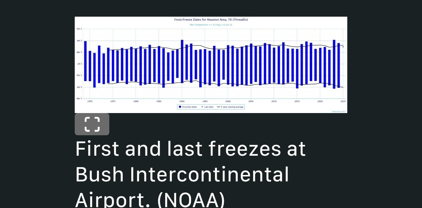 *Not all of Houston fell below freezing this morning. Much of the city's urban core along and south of I-10, as expected, appears to have remained just above freezing this morning.
*Galveston Island, as of sunrise, is a balmy 36 degrees.
*This is the peak of the cold for now, and probably will end up being our coldest day this December. 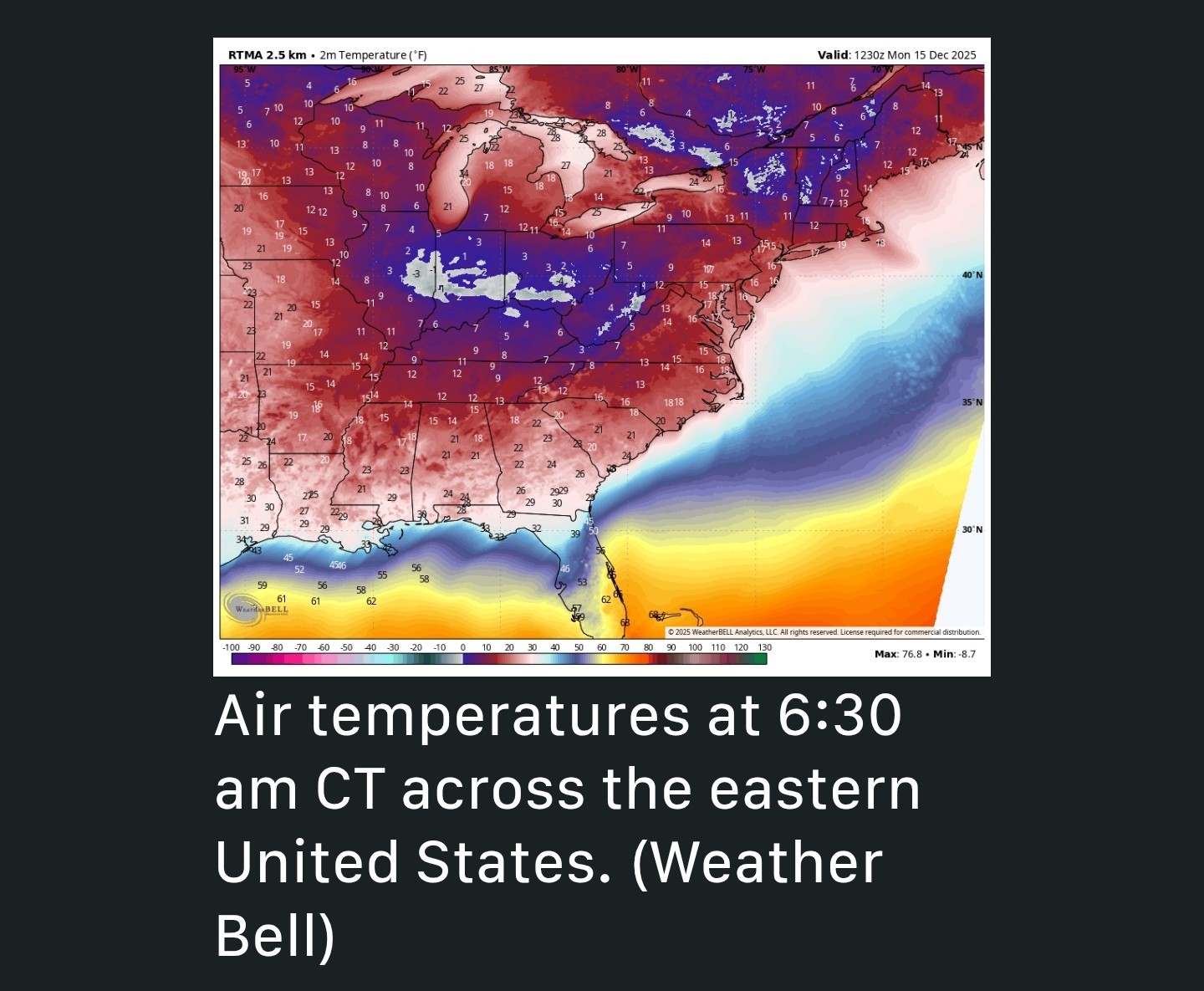 *This front was part of fairly strong Arctic outbreak, but in the end this colder air was driven down into the United States and shoved east and southeast, rather than continuing all the way down into Texas.
*Accordingly, we are seeing low 20's in southern Mississippi, Georgia, and the Carolinas this morning rather than Texas. That could easily have been us. 😬 👉 MONDAY - *Although air temperatures are very chilly this morning, at least winds have fallen off. They will remain more or less light today and tonight, although they will subtly shift to come from the east.
*We will see mostly sunny skies today, with high temperatures in the mid-50's.
*Lows tonight should be 3 to 5 degrees warmer than Sunday night, so we do not anticipate another freeze in the region. 👉 TUESDAY - *After a chilly start, this will be a mostly cloudy day, with highs in the mid-60's.
*Southeasterly winds will herald the arrival of a more robust onshore flow.
*Lows on Tuesday night will only drop into the 50's. 👉 WEDNESDAY and THURSDAY - *These will be a pair of warmer, and more humid days.
*Wednesday should have a few more clouds, and potentially some light showers (expect accumulations of less than one-quarter inch, for most), and this could help limit highs in the mid-70's.
*Thursday will have a little more sunshine, I think, and this may allow temperatures to push upwards of 80 degrees.
*At some point on Thursday night, a cool front will push through, so we probably will wake up to chillier conditions on Friday morning; It should be a dry passage. 👉 FRIDAY - *This will be a short-lived front, but it will make things feel seasonal on Friday.
*I'd expect morning lows in the vicinity of 50 degrees, followed by a sunny day in the 60s.
*Lows on Friday night should, once again, drop to around 50 degrees.
*This will likely be our final visitation of winter-like weather until after the Christmas holiday. 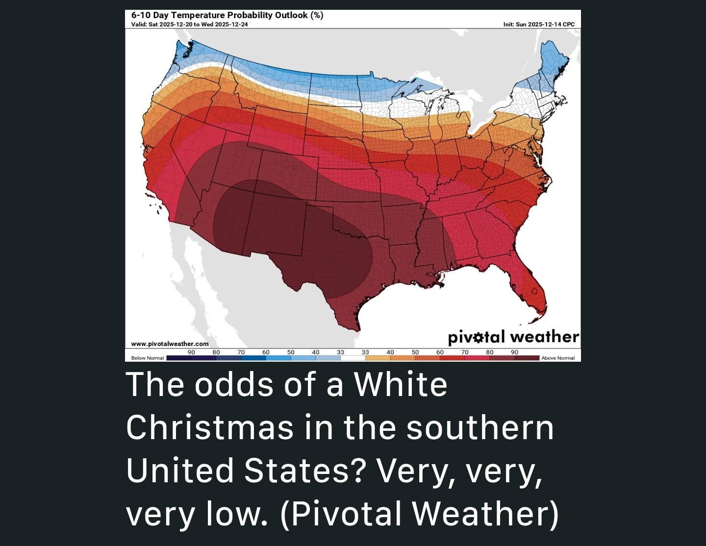 👉 SATURDAY, SUNDAY, and BEYOND - *After this, the most likely scenario is about a week of warm and fairly humid weather.
*Highs in the 70's (possibly pushing 80 some days) and lows in the 60's.
*Skies will be partly cloudy with the occasional odd chance at some light rain showers.
*It is not completely out of the question that we see some sort of front during the run-up to Christmas 🎄 but at this point I would not put chances above 10 percent.
*There is some evidence of a pattern change prior to the start of the new year🥂 but that is far enough into the future such that I have low confidence in the forecast. So yeah - by far the most likely outcome for Christmas Day 🎅 is mostly cloudy with highs in the upper 70's 🔥 with the potential for a very foggy start. 🌫 spacecityweather.com /houston-records-its -first-freeze-since- february-as-reg Happy Monday, KDC 💚💚💚
golfshot, Orangeapple and teatime reacted 👉 TUESDAY: Mostly cloudy with highs in the mid 60s.
👉 WEDNESDAY; Warm conditions with light showers possible.
👉 THURSDAY; Partly sunny with highs near 80.
👉 THURSDAY NIGHT/FRIDAY MORNING: Cool front; no significant rainfall expected.
👉 FRIDAY: Cooler morning in the 50s (with the passage of the front) & highs in the 60s.
👉 WEEKEND: Warm and partly cloudy with scattered light showers.
👉 CHRISTMAS DAY: Warm & humid with temperatures in the upper 70s. 🎄
👉 NEW YEAR: Possible pattern change at the first of the year but still to early to forecast.
*Our attention then turns to the potential for some light showers on Wednesday, and another brief incursion of cooler air Friday before a warm run-up to Christmas Day. 🔥
*This is the city's first freeze since February 20. If we look at average freeze dates, since the official monitoring station was moved to Bush airport in 1969, the average date of the first freeze is December 4th.
*Galveston Island, as of sunrise, is a balmy 36 degrees.
*This is the peak of the cold for now, and probably will end up being our coldest day this December.
*Accordingly, we are seeing low 20's in southern Mississippi, Georgia, and the Carolinas this morning rather than Texas. That could easily have been us. 😬
*We will see mostly sunny skies today, with high temperatures in the mid-50's.
*Lows tonight should be 3 to 5 degrees warmer than Sunday night, so we do not anticipate another freeze in the region.
*Southeasterly winds will herald the arrival of a more robust onshore flow.
*Lows on Tuesday night will only drop into the 50's.
*Wednesday should have a few more clouds, and potentially some light showers (expect accumulations of less than one-quarter inch, for most), and this could help limit highs in the mid-70's.
*Thursday will have a little more sunshine, I think, and this may allow temperatures to push upwards of 80 degrees.
*At some point on Thursday night, a cool front will push through, so we probably will wake up to chillier conditions on Friday morning; It should be a dry passage.
*I'd expect morning lows in the vicinity of 50 degrees, followed by a sunny day in the 60s.
*Lows on Friday night should, once again, drop to around 50 degrees.
*This will likely be our final visitation of winter-like weather until after the Christmas holiday.
*Highs in the 70's (possibly pushing 80 some days) and lows in the 60's.
*Skies will be partly cloudy with the occasional odd chance at some light rain showers.
*It is not completely out of the question that we see some sort of front during the run-up to Christmas 🎄 but at this point I would not put chances above 10 percent.
*There is some evidence of a pattern change prior to the start of the new year🥂 but that is far enough into the future such that I have low confidence in the forecast.