


Forecast after storms
Forecast after storms


Joined:
X days ago
# Posts:
X,XXX
Contributor Points:
X


Forecast after storms Our forecast for the remainder of the week - ................ From Space City Weather: After a sunny Turkey day comes a soggy weekend - TUESDAY - *After Monday's storms, including a couple of tornadoes, quieter conditions have prevailed across the region.
*Following the passage of a weak front, drier air will slowly seep into the region from the northwest today, bringing gradually falling dewpoints. However there just is not much oomph with this initial front, so most of Houston is likely to see high temperatures in the vicinity of 80 degrees today.
*In contrast to our usual daytime pattern, highs will likely be a little warmer closer to the coast, whereas areas further inland remain in the upper 70s, more influenced by the front.
*You'll notice the lower humidity by this afternoon, and this evening will feel mighty pleasant.
*Skies will be clear.
*Lows tonight will drop into the 50s for most. WEDNESDAY - *A secondary push of colder and drier air, this time with more impetus behind it, arrives on Wednesday.
*This will lead to a day with mostly sunny skies and a high temperature in the neighborhood of 70 degrees.
*Winds will be gusty in the middle of the day, up to 20 or 25 mph as the northerly air blows in.
*Our humidity will drop even further, with lows on Wednesday night falling into the 40s for most locations away from the coast. 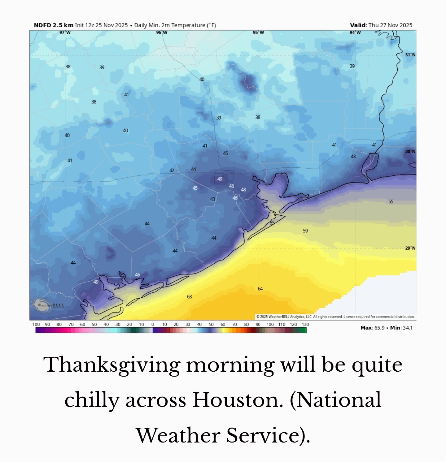 THURSDAY - *After a chilly start, Thanksgiving will be a beautiful, sunny day with highs generally in the upper 60s and light winds.
*The National Weather Service, this morning, is actually forecasting a high of 68 degrees at both Bush Intercontinental and Hobby airports.
*I'm not going to brag-as a forecaster it pays to be humble, because you're always going to miss some shots-but remember when I made that long-term Thanksgiving forecast 12 days ago? You guessed it, I predicted a high of 68 degrees. I was wrong about the rain chances, they're not 30 percent, they're closer to zero. As for the partly cloudy skies predicted then, I would go with mostly sunny instead.
*Lows on Thursday night will be similar to Wednesday night. 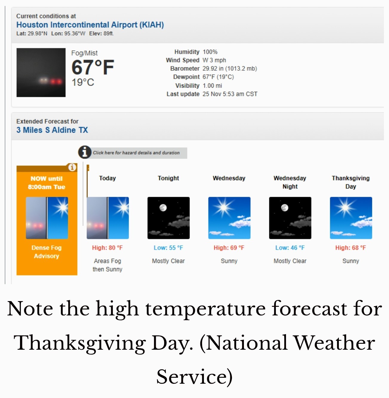 FRIDAY - *The onshore flow will kick in Thursday night or Friday morning, and this will set us on a warming curve.
*Friday will be partly to mostly cloudy, with highs around 70 degrees.
*Lows on Friday night will only drop into the 60s.
*Some slight rain chances return Friday night. SATURDAY AND SUNDAY - *An approaching frontal system from the west is going to bring wetter conditions this weekend.
*Generally, I think we can expect highs in the mid-70s on Saturday, with fairly widespread, light to moderate showers.
*It won't be wall-to-wall rain, but beginning Saturday morning we'll see healthy rain chances that persist through the weekend.
*At some point, a front is likely to move into the area, and this likely will occur on Saturday night or Sunday morning, some time.
*Sunday, therefore, will probably be cooler, in the 60s, with ongoing 60 to 70 percent rain chances.
*At this time, the weather pattern appears unlikely to support severe thunderstorms, but we shall see. NEXT WEEK - *I expect rain chances to linger after this front, probably through Monday and into Tuesday, even as we see gradually falling temperatures.
*We should see a few colder days next week, with highs perhaps only in the 50s, and lows in the upper 30s or 40s.
*I don't think a freeze is in the cards, but Houston is definitely going to feel a lot more like winter.
*We'll keep a close eye on the forecast to see how it develops, and alert you if a freeze is likely. spacecityweather.com /why-has-it-been-so- hot-this-month-also- after-a-sunny-t


golfshot, Kittle and Texasdaughter + 3 more reacted *Following the passage of a weak front, drier air will slowly seep into the region from the northwest today, bringing gradually falling dewpoints. However there just is not much oomph with this initial front, so most of Houston is likely to see high temperatures in the vicinity of 80 degrees today.
*In contrast to our usual daytime pattern, highs will likely be a little warmer closer to the coast, whereas areas further inland remain in the upper 70s, more influenced by the front.
*You'll notice the lower humidity by this afternoon, and this evening will feel mighty pleasant.
*Skies will be clear.
*Lows tonight will drop into the 50s for most.
*This will lead to a day with mostly sunny skies and a high temperature in the neighborhood of 70 degrees.
*Winds will be gusty in the middle of the day, up to 20 or 25 mph as the northerly air blows in.
*Our humidity will drop even further, with lows on Wednesday night falling into the 40s for most locations away from the coast.
*The National Weather Service, this morning, is actually forecasting a high of 68 degrees at both Bush Intercontinental and Hobby airports.
*I'm not going to brag-as a forecaster it pays to be humble, because you're always going to miss some shots-but remember when I made that long-term Thanksgiving forecast 12 days ago? You guessed it, I predicted a high of 68 degrees. I was wrong about the rain chances, they're not 30 percent, they're closer to zero. As for the partly cloudy skies predicted then, I would go with mostly sunny instead.
*Lows on Thursday night will be similar to Wednesday night.
*Friday will be partly to mostly cloudy, with highs around 70 degrees.
*Lows on Friday night will only drop into the 60s.
*Some slight rain chances return Friday night.
*Generally, I think we can expect highs in the mid-70s on Saturday, with fairly widespread, light to moderate showers.
*It won't be wall-to-wall rain, but beginning Saturday morning we'll see healthy rain chances that persist through the weekend.
*At some point, a front is likely to move into the area, and this likely will occur on Saturday night or Sunday morning, some time.
*Sunday, therefore, will probably be cooler, in the 60s, with ongoing 60 to 70 percent rain chances.
*At this time, the weather pattern appears unlikely to support severe thunderstorms, but we shall see.
*We should see a few colder days next week, with highs perhaps only in the 50s, and lows in the upper 30s or 40s.
*I don't think a freeze is in the cards, but Houston is definitely going to feel a lot more like winter.
*We'll keep a close eye on the forecast to see how it develops, and alert you if a freeze is likely.
Replies:
StormChaser : Sounds good, except for the freeze part! I have been thoroughly enjoying my blooming, green gardens!
Oddly, I have no plans for this weekend. Dec is crazy busy for me. So im going to enjoy the quiet.
Kittle and StormChaser reacted
Looking forward to the chilly outbreak next week! If we're going to have a warm/cold back & forth pattern this winter, we better be prepared for severe weather more than once.
Kittle, StormChaser and Txbutterfly reacted
Oddly, I have no plans for this weekend. Dec is crazy busy for me. So im going to enjoy the quiet.
Txbutterfly :
StormChaser : Thanks for the update. We are looking forward to a nice chilly Thanksgiving.
« Back to Chat
Views: 340
# Replies: 6