


This week's forecast
This week's forecast


Joined:
X days ago
# Posts:
X,XXX
Contributor Points:
X


This week's forecast - Higher than normal temperature continue thru mid week.
- A front arrives on Thursday which will bring us some much needed rainfall (thru Friday) and more seasonal like temperatures.
- Next weekend will be cooler with decent rain chances. ................................ From Space City Weather: Houston will push record highs this week before our first serious rains since October. Eric Berger · Monday, November 17, 2025 7:12 AM In brief: *In today's post we discuss record heat in November, with a couple of days this week likely breaking high temperature marks.
*Houston is also going to finally see some meaningful rainfall this week, likely beginning on Thursday, ahead of a front. HEAT AND DROUGHT - Let's start with record setting daytime warmth for Houston. 🔥 Monday thru Thursday of this week are going to bring high temperatures in the mid- (and for some locations) upper-80s. Here are the city's current record highs for these days, along with forecast highs in parentheses: 🌡 Nov. 17: 86 degrees (85)
🌡 Nov. 18: 84 degrees (87)
🌡 Nov. 19: 85 degrees (86)
🌡 Nov. 20: 84 degrees (85) *The record warmth is coming as the Houston region continues to advance toward a severe drought.
*According to the latest data from NOAA, through mid-November the region has received only about 10 to 50 percent of normal rainfall during the last two months.
*Much of the region has received almost no rainfall during the month of November. It's very dry outside. 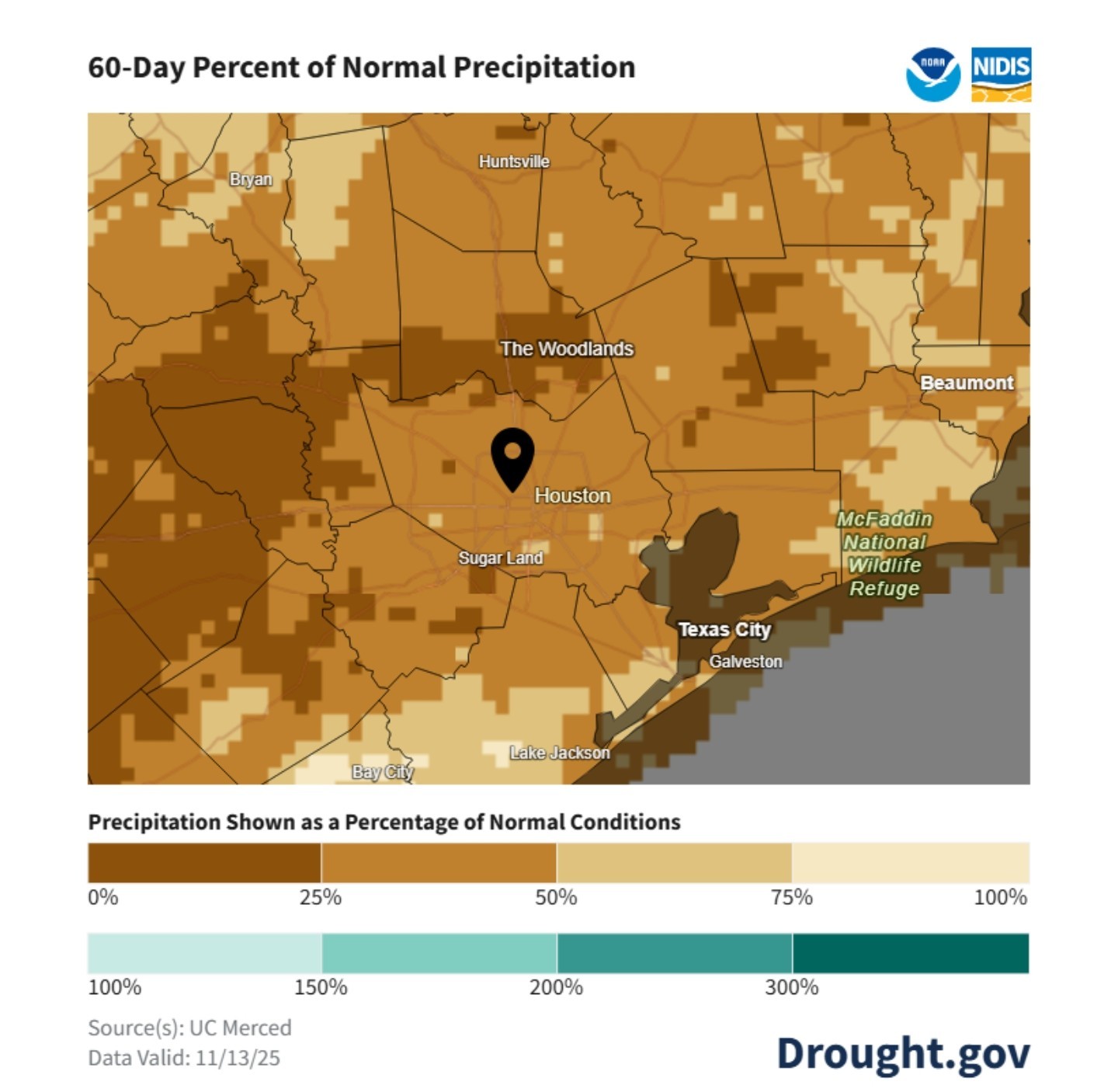 *During the last 60 days most of the Houston region has received 10 to 50 percent of normal precipitation.
*With all of that said, cooler temperatures and more rainfall are finally in the forecast.
*Rains will arrive by Wednesday or Thursday of this week, and we should begin to cool down some by this weekend.
*Longer term, by around Thanksgiving or shortly thereafter, we could see significantly colder weather. MONDAY AND TUESDAY - These days will be uncharacteristically sticky for mid-November. *The first two days of this week will more or less see a continuation of the warm and humid weather the region experienced this weekend.
*Daytime temperatures will be in the mid-80s for much of the city, with inland locations pushing into the upper 80s.
*Skies will be partly sunny. With dewpoints in the vicinity of 70 degrees it will be very sticky outside.
*Additionally, as overnight lows only fall to around 70 degrees, we probably will see some patchy fog develop.
*Winds will be light in the morning, but increasing to 10 to 15 mph during the afternoons. 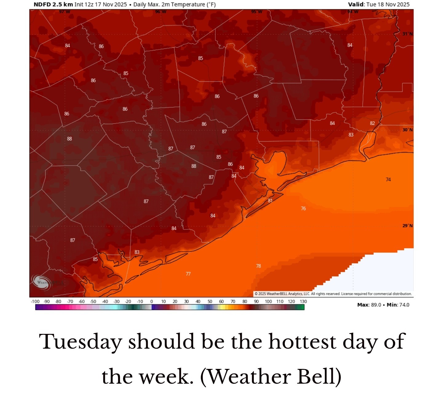 WEDNESDAY - *We'll see more clouds on Wednesday, and this should cap high temperatures in the mid-80s.
*We'll also see a slight chance of rain, but I would only put the likelihood in the ballpark of 10 to 20 percent.
*Nighttime temperatures remain warm and muggy. THURSDAY AND FRIDAY - *Rain chances will increase to 50 percent, or higher, on Thursday as a series of disturbances begin to pass overhead.
*Highs Thursday will depend on the extent of rainfall, but I expect most of the area to reach the low- to mid-80s.
*This somewhat rainy pattern will continue into Friday.
*At some point (and I confess the timing is not yet clear) a front is going to push through the area on Friday and bring with it a line of showers and thunderstorms.
*Overall conditions with the front don't appear to favor anything too severe, but we'll be keeping an eye on things.
*Highs should be in the vicinity of 80 degrees on Friday, depending on the timing of the front. 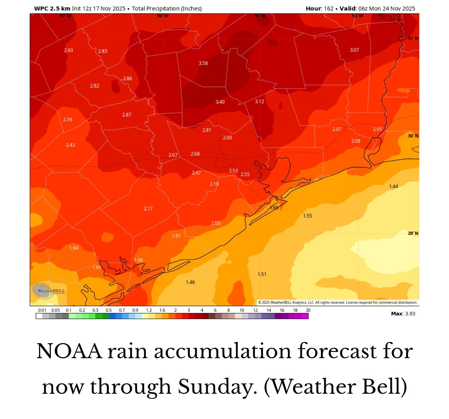 SATURDAY AND SUNDAY - *Our weather this weekend will depend on the strength of the front, and there remains some question on just how much cooler and drier air will reach Houston. )I think there will be a decent amount, but we shall see.)
*For now, let's go with highs in the 70s and lows on Saturday and Sunday night in the 50s, with lower humidity.
*I also think both days will continue to see a decent chance of rain showers, but again this will depend on where and when the front stalls. So the bottom line is that our forecast for this weekend is uncertain: could be mildly warm and rainier, or a little cooler with less rainfall. Stay tuned. NEXT WEEK - *Our somewhat cooler and less humid weather should persist through the middle of next week.
*By around next Thursday- yes, Thanksgiving Day -there are hints in some of our models of a stronger front arriving.
*It's far too early to say whether this colder air will arrive by Thanksgiving, or a day or two later.
*However, if you've been pining for some colder nights. It does look like we could be about 10 days away from this.


cbear, CatalinaKitKat and peppermintstick reacted - A front arrives on Thursday which will bring us some much needed rainfall (thru Friday) and more seasonal like temperatures.
- Next weekend will be cooler with decent rain chances.
*Houston is also going to finally see some meaningful rainfall this week, likely beginning on Thursday, ahead of a front.
🌡 Nov. 18: 84 degrees (87)
🌡 Nov. 19: 85 degrees (86)
🌡 Nov. 20: 84 degrees (85)
*According to the latest data from NOAA, through mid-November the region has received only about 10 to 50 percent of normal rainfall during the last two months.
*Much of the region has received almost no rainfall during the month of November. It's very dry outside.
*With all of that said, cooler temperatures and more rainfall are finally in the forecast.
*Rains will arrive by Wednesday or Thursday of this week, and we should begin to cool down some by this weekend.
*Longer term, by around Thanksgiving or shortly thereafter, we could see significantly colder weather.
*Daytime temperatures will be in the mid-80s for much of the city, with inland locations pushing into the upper 80s.
*Skies will be partly sunny. With dewpoints in the vicinity of 70 degrees it will be very sticky outside.
*Additionally, as overnight lows only fall to around 70 degrees, we probably will see some patchy fog develop.
*Winds will be light in the morning, but increasing to 10 to 15 mph during the afternoons.
*We'll also see a slight chance of rain, but I would only put the likelihood in the ballpark of 10 to 20 percent.
*Nighttime temperatures remain warm and muggy.
*Highs Thursday will depend on the extent of rainfall, but I expect most of the area to reach the low- to mid-80s.
*This somewhat rainy pattern will continue into Friday.
*At some point (and I confess the timing is not yet clear) a front is going to push through the area on Friday and bring with it a line of showers and thunderstorms.
*Overall conditions with the front don't appear to favor anything too severe, but we'll be keeping an eye on things.
*Highs should be in the vicinity of 80 degrees on Friday, depending on the timing of the front.
*For now, let's go with highs in the 70s and lows on Saturday and Sunday night in the 50s, with lower humidity.
*I also think both days will continue to see a decent chance of rain showers, but again this will depend on where and when the front stalls.
*By around next Thursday- yes, Thanksgiving Day -there are hints in some of our models of a stronger front arriving.
*It's far too early to say whether this colder air will arrive by Thanksgiving, or a day or two later.
*However, if you've been pining for some colder nights. It does look like we could be about 10 days away from this.
Replies:
StormChaser : Thanks for the forecast. Looking forward to cooler weather again and we definitely need rain.
This week's forecast - Higher than normal temperature continue thru mid week. - A front arrives on Thursday which will bring us some much needed rainfall (thru Friday) and more seasonal like temperatures. - Next weekend will be cooler with decent rain chances. ................................ From Space City Weather: Houston will push record highs this week before our first serious rains since October. Eric Berger · Monday, November 17, 2025 7:12 AM In brief: *In today's post we discuss record heat in November, with a couple of days this week likely breaking high temperature marks. *Houston is also going to finally see some meaningful rainfall this week, likely beginning on Thursday, ahead of a front. HEAT AND DROUGHT - Let's start with record setting daytime warmth for Houston. 🔥 Monday thru Thursday of this week are going to bring high temperatures in the mid- (and for some locations) upper-80s. Here are the city's current record highs for these days, along with forecast highs in parentheses: 🌡 Nov. 17: 86 degrees (85) 🌡 Nov. 18: 84 degrees (87) 🌡 Nov. 19: 85 degrees (86) 🌡 Nov. 20: 84 degrees (85) *The record warmth is coming as the Houston region continues to advance toward a severe drought. *According to the latest data from NOAA, through mid-November the region has received only about 10 to 50 percent of normal rainfall during the last two months. *Much of the region has received almost no rainfall during the month of November. It's very dry outside. *During the last 60 days most of the Houston region has received 10 to 50 percent of normal precipitation. *With all of that said, cooler temperatures and more rainfall are finally in the forecast. *Rains will arrive by Wednesday or Thursday of this week, and we should begin to cool down some by this weekend. *Longer term, by around Thanksgiving or shortly thereafter, we could see significantly colder weather. MONDAY AND TUESDAY - These days will be uncharacteristically sticky for mid-November. *The first two days of this week will more or less see a continuation of the warm and humid weather the region experienced this weekend. *Daytime temperatures will be in the mid-80s for much of the city, with inland locations pushing into the upper 80s. *Skies will be partly sunny. With dewpoints in the vicinity of 70 degrees it will be very sticky outside. *Additionally, as overnight lows only fall to around 70 degrees, we probably will see some patchy fog develop. *Winds will be light in the morning, but increasing to 10 to 15 mph during the afternoons. WEDNESDAY - *We'll see more clouds on Wednesday, and this should cap high temperatures in the mid-80s. *We'll also see a slight chance of rain, but I would only put the likelihood in the ballpark of 10 to 20 percent. *Nighttime temperatures remain warm and muggy. THURSDAY AND FRIDAY - *Rain chances will increase to 50 percent, or higher, on Thursday as a series of disturbances begin to pass overhead. *Highs Thursday will depend on the extent of rainfall, but I expect most of the area to reach the low- to mid-80s. *This somewhat rainy pattern will continue into Friday. *At some point (and I confess the timing is not yet clear) a front is going to push through the area on Friday and bring with it a line of showers and thunderstorms. *Overall conditions with the front don't appear to favor anything too severe, but we'll be keeping an eye on things. *Highs should be in the vicinity of 80 degrees on Friday, depending on the timing of the front. SATURDAY AND SUNDAY - *Our weather this weekend will depend on the strength of the front, and there remains some question on just how much cooler and drier air will reach Houston. )I think there will be a decent amount, but we shall see.) *For now, let's go with highs in the 70s and lows on Saturday and Sunday night in the 50s, with lower humidity. *I also think both days will continue to see a decent chance of rain showers, but again this will depend on where and when the front stalls. So the bottom line is that our forecast for this weekend is uncertain: could be mildly warm and rainier, or a little cooler with less rainfall. Stay tuned. NEXT WEEK - *Our somewhat cooler and less humid weather should persist through the middle of next week. *By around next Thursday- yes, Thanksgiving Day -there are hints in some of our models of a stronger front arriving. *It's far too early to say whether this colder air will arrive by Thanksgiving, or a day or two later. *However, if you've been pining for some colder nights. It does look like we could be about 10 days away from this.
StormChaser : peppermintstick : I heard that both airports broke a record yesterday!!!
StormChaser : peppermintstick : I heard that both airports broke a record yesterday!!!
cbear : Correct. « Back to Chat
Views: 288
# Replies: 4