


Warming trend begins before cold front
Warming trend begins before cold front


Joined:
X days ago
# Posts:
X,XXX
Contributor Points:
X


Warming trend begins before cold front Looks like we'll see 30s to our north on Monday AM 🥶 and rain chances remain near zero for the foreseeable future. Warming trend on tap for Houston ahead of a sharp, short front this weekend Eric Berger · Wednesday, November 5, 2025 6:14 AM In brief:
*Houston's forecast remains more or less the same, with a warming days and nights heading into the weekend, followed by a sharp cooldown on Saturday night.
*This front will be relatively short-lived but will bring two cold nights into the region. Wednesday - *Lows are about 10 degrees warmer this morning, but this will still be our coolest morning until Monday, probably.
*Winds are calm, but will be southerly later this morning, indicating the ongoing return of the onshore flow.
*Highs will be in the vicinity of 80 degrees.
*Skies will be mostly clear today, and remain so for pretty much the rest of the week as high pressure dominates.
*Low temperatures tonight will drop into the lower 60s, with slightly cooler conditions for outlying areas. Thursday - *A similar day to Wednesday, although the southeasterly winds may be slightly more pronounced, and humidity levels a touch higher.
*Highs, again, will be around 80 degrees, or just a bit warmer.
*Lows on Thursday night will only drop into the upper 60s. 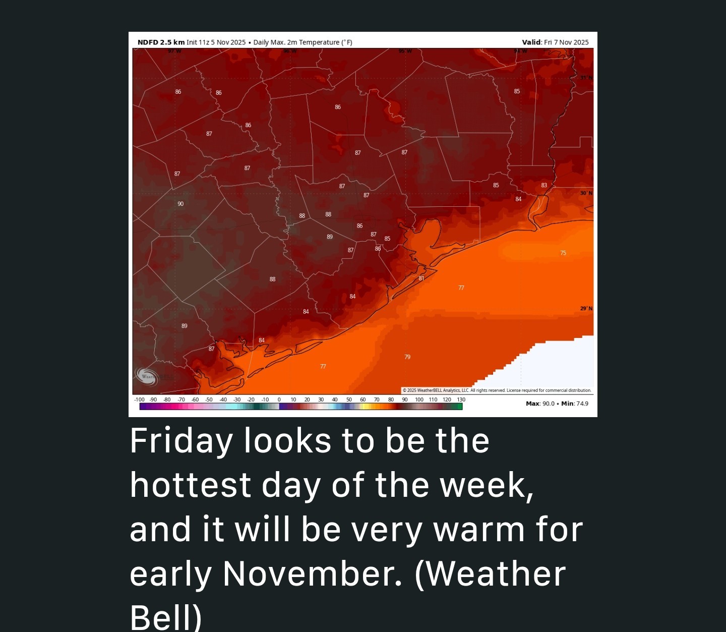 Friday and Saturday - *These will be warmer days, especially for early November.
*Expect highs in the mid to upper 80s across the region with mostly sunny skies.
*With dewpoints in the 60s, it will feel humid, but not super sultry like the summertime in Houston.
*Lows will drop into the 60s on both nights, although areas north of I-10 may see cooler temperatures later on Saturday night because I think the front will reach our northern areas on Saturday evening or night (and push off the coast by around sunrise)
*This looks like a dry passage although winds should pretty rapidly shift to come from the north. Sunday - *This will be a breezy, sunny day with highs likely topping out in the lower 70s.
*Temperatures on Sunday night will drop into the mid-40s in Houston with cooler conditions further inland. 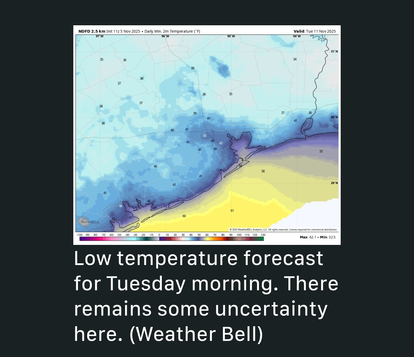 Monday - *We are going to see ideal cooling conditions on Monday and Monday night, with lighter winds.
*Expect highs to perhaps only reach the low to mid 60s.
🥶 As for Monday night, temperatures should drop into the 30s to the north of Houston, with a few areas near (i.e. Trinity and Polk counties) but not within the Houston metro area flirting with a light freeze.
🥶 In Houston itself, I think temperatures remain in the vicinity of 40 degrees, but this is likely to be the region's coldest night of the season. The rest of next week - *Tuesday is likely to bring highs of around 70 degrees before we return to temperatures of around 80 degrees for the rest of the work week.
*As for rain chances, they're very low, to zero, for the next 10 days.


CatalinaKitKat, cbear and HappyinTX + 3 more reacted *Houston's forecast remains more or less the same, with a warming days and nights heading into the weekend, followed by a sharp cooldown on Saturday night.
*This front will be relatively short-lived but will bring two cold nights into the region.
*Winds are calm, but will be southerly later this morning, indicating the ongoing return of the onshore flow.
*Highs will be in the vicinity of 80 degrees.
*Skies will be mostly clear today, and remain so for pretty much the rest of the week as high pressure dominates.
*Low temperatures tonight will drop into the lower 60s, with slightly cooler conditions for outlying areas.
*Highs, again, will be around 80 degrees, or just a bit warmer.
*Lows on Thursday night will only drop into the upper 60s.
*Expect highs in the mid to upper 80s across the region with mostly sunny skies.
*With dewpoints in the 60s, it will feel humid, but not super sultry like the summertime in Houston.
*Lows will drop into the 60s on both nights, although areas north of I-10 may see cooler temperatures later on Saturday night because I think the front will reach our northern areas on Saturday evening or night (and push off the coast by around sunrise)
*This looks like a dry passage although winds should pretty rapidly shift to come from the north.
*Temperatures on Sunday night will drop into the mid-40s in Houston with cooler conditions further inland.
*Expect highs to perhaps only reach the low to mid 60s.
🥶 As for Monday night, temperatures should drop into the 30s to the north of Houston, with a few areas near (i.e. Trinity and Polk counties) but not within the Houston metro area flirting with a light freeze.
🥶 In Houston itself, I think temperatures remain in the vicinity of 40 degrees, but this is likely to be the region's coldest night of the season.
*As for rain chances, they're very low, to zero, for the next 10 days.
Replies:
StormChaser : thanks for sharing. I hope it is seasonal for Thanksgiving and not hot.
I am so ready for the next cool front. It is not bad out this morning, but it is too humid and the air feels thick.
StormChaser and golfshot reacted
I am so ready for the next cool front. It is not bad out this morning, but it is too humid and the air feels thick.
Weathergirl5 : I LOVED it this morning! It was perfect. Still is! I'm not a huge cold fan so these temperatures are great!

Warming trend begins before cold front Looks like we'll see 30s to our north on Monday AM 🥶 and rain chances remain near zero for the foreseeable future. Warming trend on tap for Houston ahead of a sharp, short front this weekend Eric Berger · Wednesday, November 5, 2025 6:14 AM In brief: *Houston's forecast remains more or less the same, with a warming days and nights heading into the weekend, followed by a sharp cooldown on Saturday night. *This front will be relatively short-lived but will bring two cold nights into the region. Wednesday - *Lows are about 10 degrees warmer this morning, but this will still be our coolest morning until Monday, probably. *Winds are calm, but will be southerly later this morning, indicating the ongoing return of the onshore flow. *Highs will be in the vicinity of 80 degrees. *Skies will be mostly clear today, and remain so for pretty much the rest of the week as high pressure dominates. *Low temperatures tonight will drop into the lower 60s, with slightly cooler conditions for outlying areas. Thursday - *A similar day to Wednesday, although the southeasterly winds may be slightly more pronounced, and humidity levels a touch higher. *Highs, again, will be around 80 degrees, or just a bit warmer. *Lows on Thursday night will only drop into the upper 60s. Friday and Saturday - *These will be warmer days, especially for early November. *Expect highs in the mid to upper 80s across the region with mostly sunny skies. *With dewpoints in the 60s, it will feel humid, but not super sultry like the summertime in Houston. *Lows will drop into the 60s on both nights, although areas north of I-10 may see cooler temperatures later on Saturday night because I think the front will reach our northern areas on Saturday evening or night (and push off the coast by around sunrise) *This looks like a dry passage although winds should pretty rapidly shift to come from the north. Sunday - *This will be a breezy, sunny day with highs likely topping out in the lower 70s. *Temperatures on Sunday night will drop into the mid-40s in Houston with cooler conditions further inland. Monday - *We are going to see ideal cooling conditions on Monday and Monday night, with lighter winds. *Expect highs to perhaps only reach the low to mid 60s. 🥶 As for Monday night, temperatures should drop into the 30s to the north of Houston, with a few areas near (i.e. Trinity and Polk counties) but not within the Houston metro area flirting with a light freeze. 🥶 In Houston itself, I think temperatures remain in the vicinity of 40 degrees, but this is likely to be the region's coldest night of the season. The rest of next week - *Tuesday is likely to bring highs of around 70 degrees before we return to temperatures of around 80 degrees for the rest of the work week. *As for rain chances, they're very low, to zero, for the next 10 days.
StormChaser : Disappointed in no rain chances. I am concerned about fires as I know people are still burning. I will need to use the COH water dept to top off pool. I don't ever remember having to do that in November in 23 years! Rrrrrrrrr. « Back to Chat
Views: 279
# Replies: 5