


Weak front arrives this Thursday
Weak front arrives this Thursday


Joined:
X days ago
# Posts:
X,XXX
Contributor Points:
X


Weak front arrives this Thursday Less humid weather on the horizon as a weak front arrives Thursday. Eric Berger · Wednesday, October 8, 2025 7:27 AM In brief:
*Houston is not out there setting records, but temperatures are definitely running well above normal for early October.
*However, some modest relief is on the way with a weak front arriving on Thursday. *Unfortunately, it is unlikely to bring much rain, which we could use with another dry spell ahead. Early October heat - *The average high so far this month has been about 93 degrees, well above the normal of 85 to 87 degrees.
*The heat has not been record-setting, but it's definitely been warm for this time of year.
*Thanks to the arrival of a weak front on Thursday we are going to see daily highs and lows come down a few degrees.
*We still will be slightly above normal - but thanks to drier air - the mornings and evenings will definitely feel more pleasant after today. Wednesday - *Highs today will get into the low to mid 90s for much of the region & skies will be mostly sunny.
*On Tuesday afternoon, along the sea breeze, we saw the development of some isolated to scattered showers, and that pattern will remain in place today.
*Overall chances are fairly low, probably on the order of 20 percent. Paltry as that may be, however, they do represent our best rain chances for awhile.
*After today, and well into next week, overall daily rain chances look to be on the order of zero percent.
*We'll have another fairly sultry night, with lows in the lower 70s. Thursday - *This will be a sunny day with highs once again will likely reach the lower 90s.
*However, during the afternoon winds should start to increase from the northeast, and this will be the beginning of the influx of a drier air mass.
*Some time after midnight dewpoints will drop into the 50s, with air temperatures in the 60s for much of the region. Friday - *This will be a sunny day with a high temperature in the upper 80s and fine, dry air.
*Lows Friday night will drop into the 60s but how far will depend on how far you live from the coast. 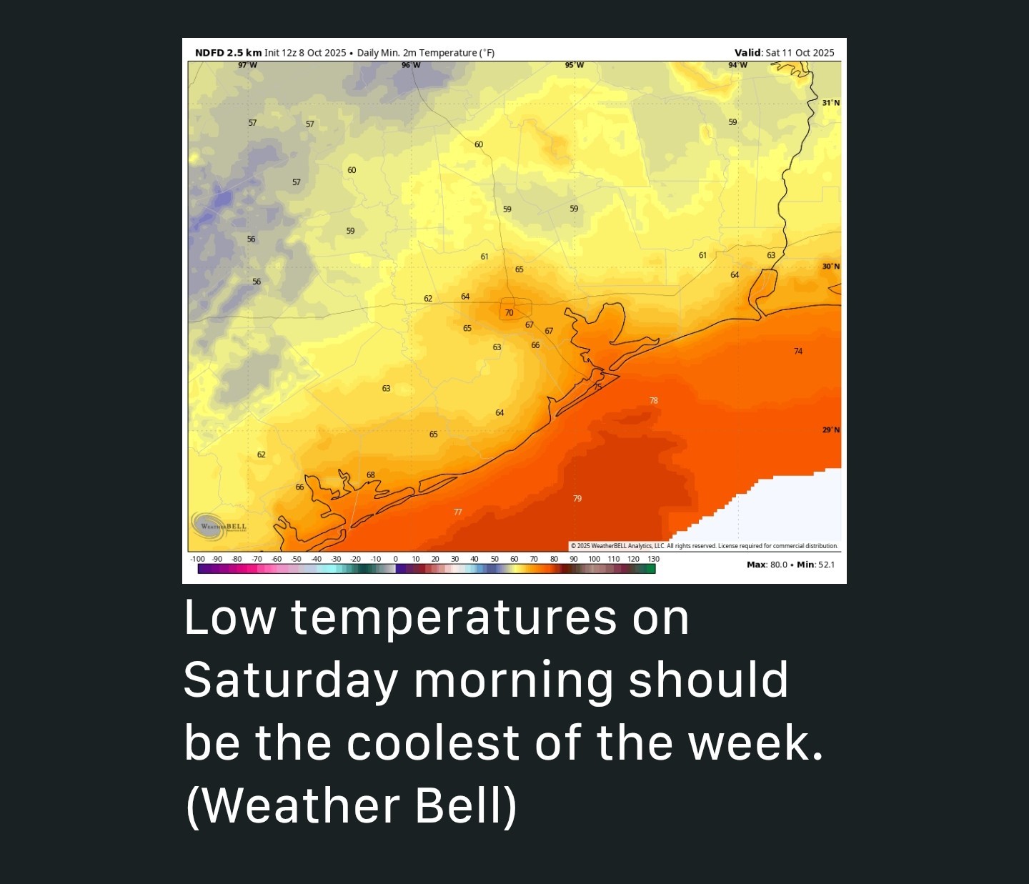 Saturday and Sunday - *Our sunny weather with modest humidity, continues.
*Highs will be in the vicinity of the upper 80s to 90 degrees.
*Lows will be in the upper 60s to 70 degrees.
*With sunny skies, rain chances remain near zero. Next week - *This pattern of late summer/early fall-like weather continues next week.
*Humidity won't be low but it won't be super high either.
*Clouds will be difficult to find.
*The forecast models are still hinting at the possibility of some kind of change toward the end of next week, or the weekend but there is no strong signal yet for what is to come.


CatalinaKitKat, ZMAN and Txbutterfly reacted *Houston is not out there setting records, but temperatures are definitely running well above normal for early October.
*However, some modest relief is on the way with a weak front arriving on Thursday. *Unfortunately, it is unlikely to bring much rain, which we could use with another dry spell ahead.
*The heat has not been record-setting, but it's definitely been warm for this time of year.
*Thanks to the arrival of a weak front on Thursday we are going to see daily highs and lows come down a few degrees.
*We still will be slightly above normal - but thanks to drier air - the mornings and evenings will definitely feel more pleasant after today.
*On Tuesday afternoon, along the sea breeze, we saw the development of some isolated to scattered showers, and that pattern will remain in place today.
*Overall chances are fairly low, probably on the order of 20 percent. Paltry as that may be, however, they do represent our best rain chances for awhile.
*After today, and well into next week, overall daily rain chances look to be on the order of zero percent.
*We'll have another fairly sultry night, with lows in the lower 70s.
*However, during the afternoon winds should start to increase from the northeast, and this will be the beginning of the influx of a drier air mass.
*Some time after midnight dewpoints will drop into the 50s, with air temperatures in the 60s for much of the region.
*Lows Friday night will drop into the 60s but how far will depend on how far you live from the coast.
*Highs will be in the vicinity of the upper 80s to 90 degrees.
*Lows will be in the upper 60s to 70 degrees.
*With sunny skies, rain chances remain near zero.
*Humidity won't be low but it won't be super high either.
*Clouds will be difficult to find.
*The forecast models are still hinting at the possibility of some kind of change toward the end of next week, or the weekend but there is no strong signal yet for what is to come.
Replies:
StormChaser : I'll take it! It would be nice to get some rain, but it will be great to have the lower humidity and cooler temps this weekend! Thank you for the update, as always.
« Back to Chat
Views: 282
# Replies: 4