


This week's forecast
This week's forecast


Joined:
X days ago
# Posts:
X,XXX
Contributor Points:
X


This week's forecast Late summer weather to hold on this week: mid-90s possible for a few days in spots. Eric Berger · Monday, September 29, 2025 7:04 AM In brief:
*In today's update we discuss the upcoming heat for this week, which may relent slightly by the weekend.
*We also remain in a bear market for cool fronts with nothing in the cards until at least the middle of next week. 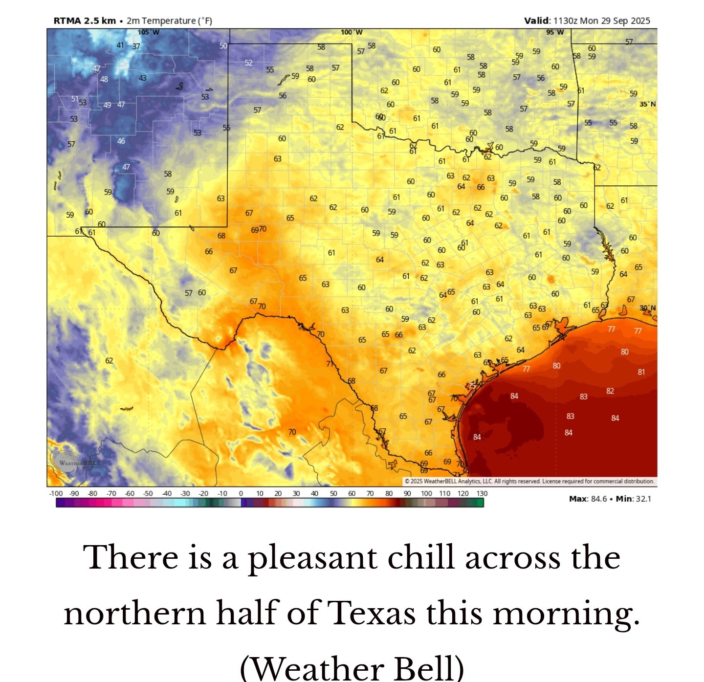 HEAT WITH OCTOBER ON THE HORIZON - *We've had a pretty typical September, in which we still have some hot days, but also get some slightly cooler nights from time to time.
*This week, the calendar turns to October, but the heat is continuing.
*Inland areas may reach the mid-90s for a couple of days (Wednesday and Thursday). How normal is this for this time of year? Well, it's not normal, but we also probably will not set any record highs. *The highest temperature recorded in Houston on October 1 is 99 degrees (1900) and on October 2 it is 97 degrees (1938).
*So yes, our highs are likely to run several degrees above normal this week, but we should fall short of record heat.
*And this week's soaring temperatures serve as a reminder that although fall is clearly on the horizon, we're still dealing with the remnants of summer. MONDAY - *High temperatures today should remain in the lower 90s for most of the area with a nice amount of dry air & sunny skies.
*Nighttime temperatures should be several degrees warmer, perhaps dropping only into the lower 70s, as some clouds build overhead due to a passing disturbance. 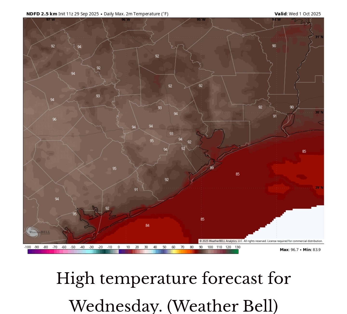 TUESDAY, WEDNESDAY, and THURSDAY - *A few clouds may linger into Tuesday morning, but for the most part these days will be sunny and hot.
*Central and southern parts of Houston may remain in the lower 90s, but some inland spots will probably hit the mid-90s with sunny skies and a fairly dry atmosphere allowing for efficient heating.
*Nighttime lows will be in the lower 70s. This probably isn't the way most of us wanted to begin October, but here we are. FRIDAY, SATURDAY, and SUNDAY - *A slightly more humid flow should moderate daily high temperatures a bit, to around 90 degrees this weekend.
*I still expect mostly sunny skies but we could also see some isolated to scattered sea breeze showers each afternoon.
*Overall, chances each day are probably about 20 percent.
*If you're participating in the 2025 Komen Houston Race for the Cure, I expect conditions to be fine on Saturday morning, with any showers (however unlikely) holding off until the afternoon. NEXT WEEK - *I expect this pattern to mostly hold for next week with highs in the vicinity of 90 degrees.
*There is some whiff of a front in the models during the second half of next week but nothing so concrete as to have any confidence at this point. We shall see. 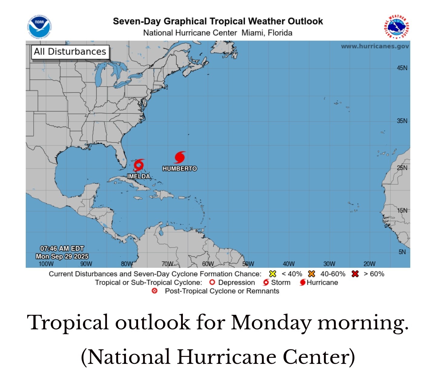 ATLANTIC TROPICS - *We have a busy scene in the Atlantic tropics with Hurricane Humberto briefly ascending to Category 5 hurricane status on Sunday. Fortunately, there is no direct threat to land.
*Tropical Storm Imelda also formed this weekend over the Bahamas, but due to interactions with Humberto, it is likely to be pulled away from the southeastern United States, out to sea.
*It is possible that a tropical disturbance develops in the southern Gulf at some point during the next week or so, but this seems unlikely to track north toward Texas and be a significant player in our weather.


Gammyof2, CatalinaKitKat and cbear + 1 more reacted *In today's update we discuss the upcoming heat for this week, which may relent slightly by the weekend.
*We also remain in a bear market for cool fronts with nothing in the cards until at least the middle of next week.
*This week, the calendar turns to October, but the heat is continuing.
*Inland areas may reach the mid-90s for a couple of days (Wednesday and Thursday).
*So yes, our highs are likely to run several degrees above normal this week, but we should fall short of record heat.
*And this week's soaring temperatures serve as a reminder that although fall is clearly on the horizon, we're still dealing with the remnants of summer.
*Nighttime temperatures should be several degrees warmer, perhaps dropping only into the lower 70s, as some clouds build overhead due to a passing disturbance.
*Central and southern parts of Houston may remain in the lower 90s, but some inland spots will probably hit the mid-90s with sunny skies and a fairly dry atmosphere allowing for efficient heating.
*Nighttime lows will be in the lower 70s.
*I still expect mostly sunny skies but we could also see some isolated to scattered sea breeze showers each afternoon.
*Overall, chances each day are probably about 20 percent.
*If you're participating in the 2025 Komen Houston Race for the Cure, I expect conditions to be fine on Saturday morning, with any showers (however unlikely) holding off until the afternoon.
*There is some whiff of a front in the models during the second half of next week but nothing so concrete as to have any confidence at this point. We shall see.
*Tropical Storm Imelda also formed this weekend over the Bahamas, but due to interactions with Humberto, it is likely to be pulled away from the southeastern United States, out to sea.
*It is possible that a tropical disturbance develops in the southern Gulf at some point during the next week or so, but this seems unlikely to track north toward Texas and be a significant player in our weather.
Replies:

This week's forecast Late summer weather to hold on this week: mid-90s possible for a few days in spots. Eric Berger · Monday, September 29, 2025 7:04 AM In brief: *In today's update we discuss the upcoming heat for this week, which may relent slightly by the weekend. *We also remain in a bear market for cool fronts with nothing in the cards until at least the middle of next week. HEAT WITH OCTOBER ON THE HORIZON - *We've had a pretty typical September, in which we still have some hot days, but also get some slightly cooler nights from time to time. *This week, the calendar turns to October, but the heat is continuing. *Inland areas may reach the mid-90s for a couple of days (Wednesday and Thursday). How normal is this for this time of year? Well, it's not normal, but we also probably will not set any record highs. *The highest temperature recorded in Houston on October 1 is 99 degrees (1900) and on October 2 it is 97 degrees (1938). *So yes, our highs are likely to run several degrees above normal this week, but we should fall short of record heat. *And this week's soaring temperatures serve as a reminder that although fall is clearly on the horizon, we're still dealing with the remnants of summer. MONDAY - *High temperatures today should remain in the lower 90s for most of the area with a nice amount of dry air & sunny skies. *Nighttime temperatures should be several degrees warmer, perhaps dropping only into the lower 70s, as some clouds build overhead due to a passing disturbance. TUESDAY, WEDNESDAY, and THURSDAY - *A few clouds may linger into Tuesday morning, but for the most part these days will be sunny and hot. *Central and southern parts of Houston may remain in the lower 90s, but some inland spots will probably hit the mid-90s with sunny skies and a fairly dry atmosphere allowing for efficient heating. *Nighttime lows will be in the lower 70s. This probably isn't the way most of us wanted to begin October, but here we are. FRIDAY, SATURDAY, and SUNDAY - *A slightly more humid flow should moderate daily high temperatures a bit, to around 90 degrees this weekend. *I still expect mostly sunny skies but we could also see some isolated to scattered sea breeze showers each afternoon. *Overall, chances each day are probably about 20 percent. *If you're participating in the 2025 Komen Houston Race for the Cure, I expect conditions to be fine on Saturday morning, with any showers (however unlikely) holding off until the afternoon. NEXT WEEK - *I expect this pattern to mostly hold for next week with highs in the vicinity of 90 degrees. *There is some whiff of a front in the models during the second half of next week but nothing so concrete as to have any confidence at this point. We shall see. ATLANTIC TROPICS - *We have a busy scene in the Atlantic tropics with Hurricane Humberto briefly ascending to Category 5 hurricane status on Sunday. Fortunately, there is no direct threat to land. *Tropical Storm Imelda also formed this weekend over the Bahamas, but due to interactions with Humberto, it is likely to be pulled away from the southeastern United States, out to sea. *It is possible that a tropical disturbance develops in the southern Gulf at some point during the next week or so, but this seems unlikely to track north toward Texas and be a significant player in our weather.
StormChaser : I am just embracing these cool mornings. I detested waking up and it is 80 already !
We need for this heat to get booted out already. We've had more than our share of heat this year, ugh!
StormChaser and golfshot reacted « Back to Chat
Views: 247
# Replies: 3