


Storms today before front arrives
Storms today before front arrives


Joined:
X days ago
# Posts:
X,XXX
Contributor Points:
X


Storms today before front arrives *A dry morning is expected before storm activity picks up after lunch.
*The 'first round' looks to produce scattered showers north of us.
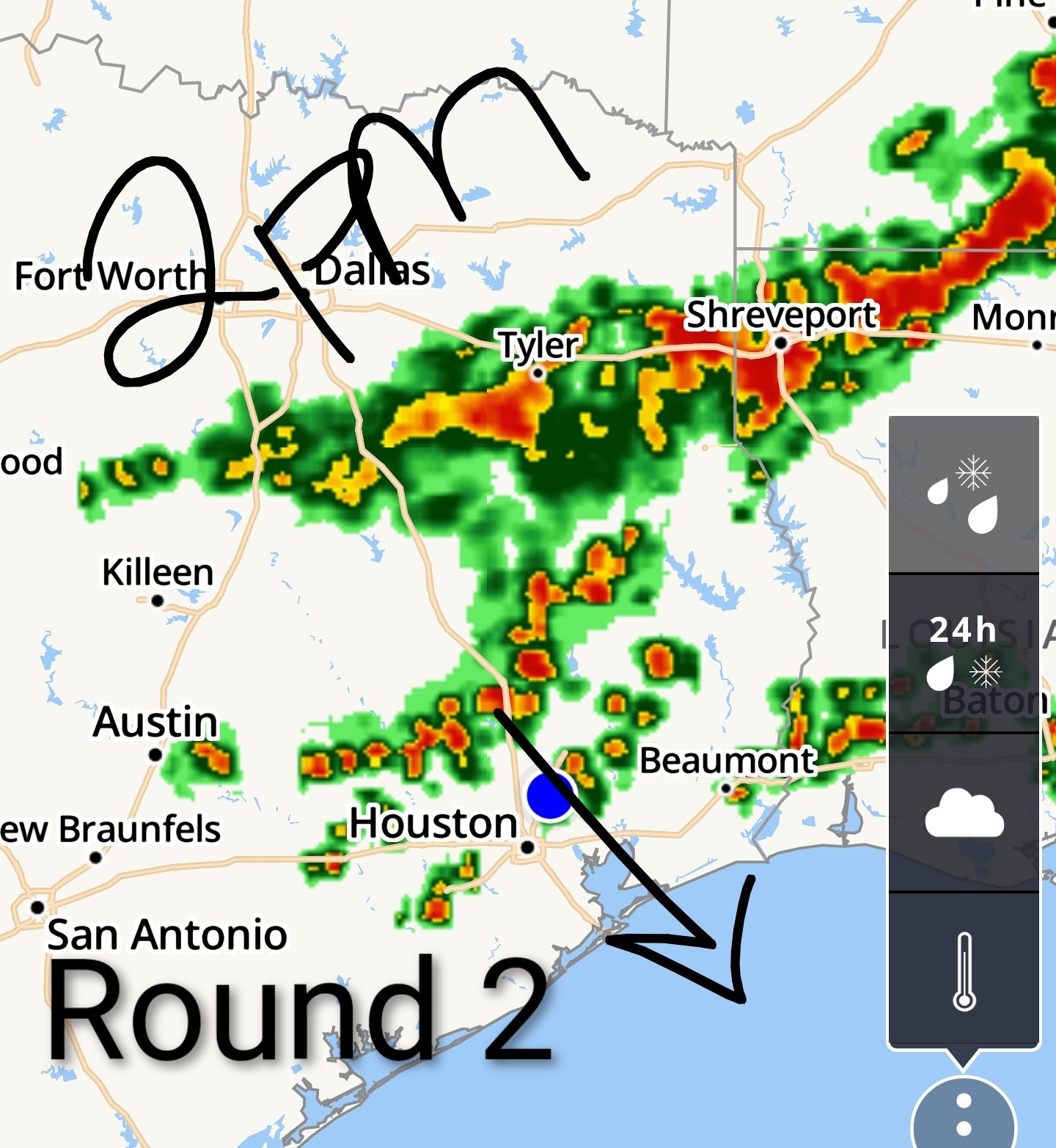
*The 'second round' should produce scattered thunderstorms across the area this afternoon.
*The 'third round' will be a line of storms with the actual front, which is expected late this afternoon/into the early evening.
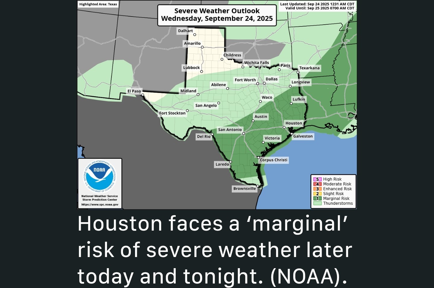
*The greatest risks are heavy rain, frequent lightning and gusty winds.
*Scattered showers linger tomorrow morning near the coast as high temps only make it into the mid-80s.
*The weekend looks beautiful with low temps around 70 and highs around 90 with much lower humidity! 🌞 ............................... From Space City Weather - Storms possible later today as front moves in, ending our extremely sultry nights for a spell. Eric Berger · Wednesday, September 24, 2025 7:00 AM In brief: *In today's post we recount the extraordinary humidity currently afflicting the region, and explain why it will soon end.
*Houston also faces the threat of storms and some heavy rainfall later this afternoon - and this evening - as a cool front moves into the area and eventually pushes off the coast. OH, THE HUMIDITY - *I don't know if you've noticed, but the humidity the last couple of nights has been extraordinary.
*This morning, just before sunrise, the low temperature at Bush Intercontinental Airport has reached a low of just 80 degrees. This is solidly 2 degrees above the previous 'record minimum' temperature at the site of 78 degrees, set back in 1945.
*The dewpoint is 79 degrees this morning, so the air is nearly saturated, and humidity is very high. It feels like deep summer out there. 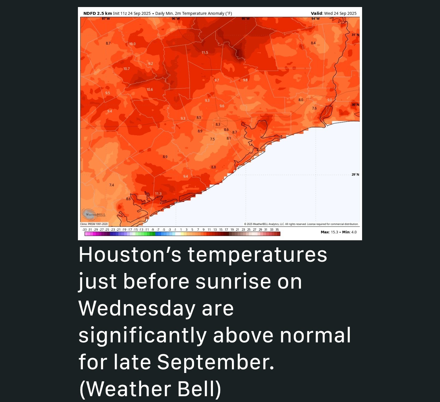 *As you cans see above, the region's minimum temperatures this morning are running 8 to 12 degrees above normal for the region. So yeah - it's pretty yuck out there. *For this reason, even though today's front is not super strong temperature wise, it will eventually bring enough drier air to make things significantly more comfortable, and our nights and evenings quite a bit more pleasant. WEDNESDAY (TODAY) - *Our radar is quiet this morning, but that is likely to change as we get later into today, and this evening, as a front slowly sags down into the region.
*Through this morning, to the extent storms develop, they probably will do so well north of the region, along and north of Highway 105 in Montgomery County.
*This afternoon we are likely to see scattered showers and thunderstorms develop in coastal counties, ahead of the front.
*By late this afternoon - or evening - a line of storms will likely coalesce to the northwest of Houston and move toward the coast, reaching offshore by around midnight or in the wee hours of Thursday morning.
*These storms will be capable of producing 2 to 4 inches of rainfall in spots, but I think most of the area will see less than this.
*Nonetheless, the threat of heavy rainfall, and possibly some damaging, straight-line winds, will be present from this evening and into Thursday morning. 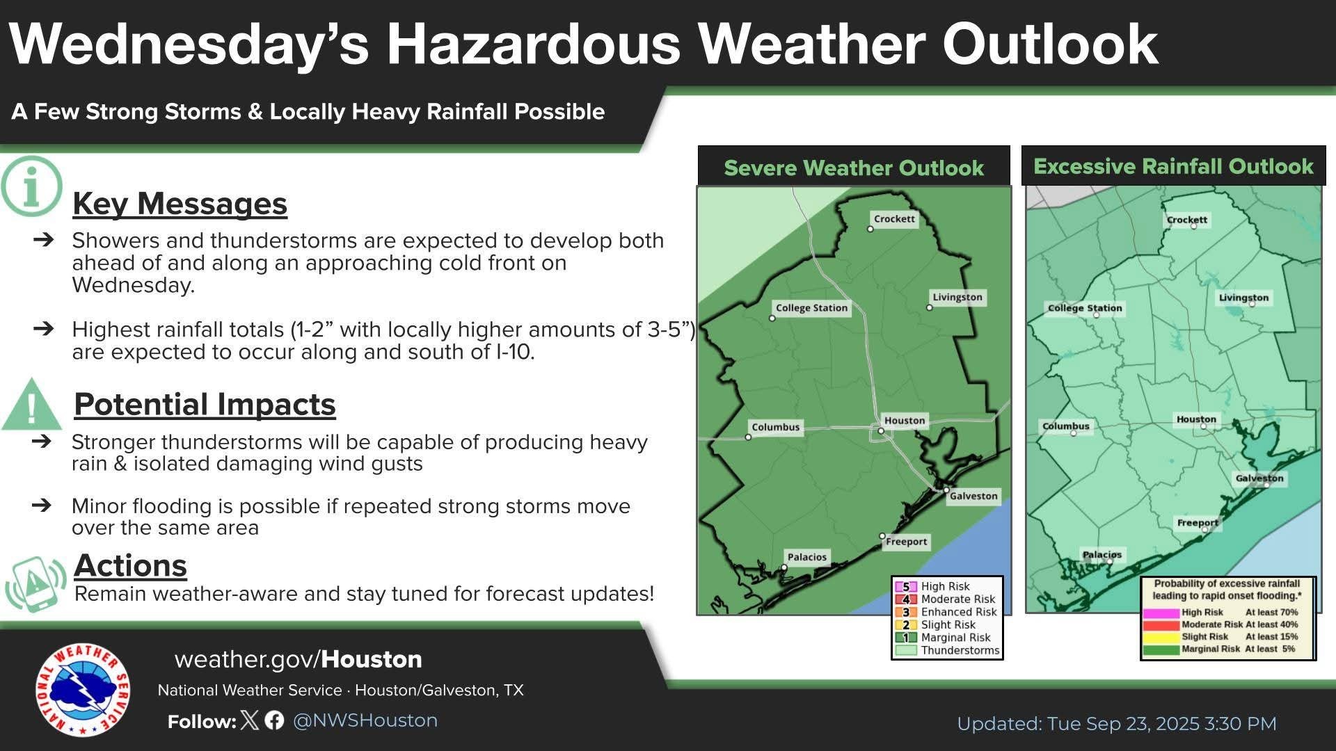 *High temperatures today will generally be in the lower 90s, with lows tonight dropping into the lower 70s.
  THURSDAY - *Some storms may linger on Thursday morning, and for the immediate coast there remains a possibility of showers into the afternoon.
*For most of the region, skies should be clearing as drier air slowly moves in.
*Expect highs in the mid-80s with northwest winds at 5 to 10 mph.
*Lows on Thursday night should drop into the 60s for most of the region away from the coast. FRIDAY, SATURDAY, AND SUNDAY - *This period should see sunny skies and modestly lower humidity.
*Daily highs will reach about 90 degrees, perhaps a degree or two lower or higher.
*Nights will be in the vicinity of 70 degrees, cooler for inland areas and slightly warmer for the coast.
*With dewpoints in the 60s, the air will be somewhat humid but not oppressively so. It should be a very fine weekend for outdoor activities. Enjoy! 🌞


rocklady2024, peppermintstick and forestfairy + 16 more reacted *The 'first round' looks to produce scattered showers north of us.
*The 'second round' should produce scattered thunderstorms across the area this afternoon.
*The 'third round' will be a line of storms with the actual front, which is expected late this afternoon/into the early evening.
*The greatest risks are heavy rain, frequent lightning and gusty winds.
*Scattered showers linger tomorrow morning near the coast as high temps only make it into the mid-80s.
*The weekend looks beautiful with low temps around 70 and highs around 90 with much lower humidity! 🌞
*Houston also faces the threat of storms and some heavy rainfall later this afternoon - and this evening - as a cool front moves into the area and eventually pushes off the coast.
*This morning, just before sunrise, the low temperature at Bush Intercontinental Airport has reached a low of just 80 degrees. This is solidly 2 degrees above the previous 'record minimum' temperature at the site of 78 degrees, set back in 1945.
*The dewpoint is 79 degrees this morning, so the air is nearly saturated, and humidity is very high.
*Through this morning, to the extent storms develop, they probably will do so well north of the region, along and north of Highway 105 in Montgomery County.
*This afternoon we are likely to see scattered showers and thunderstorms develop in coastal counties, ahead of the front.
*By late this afternoon - or evening - a line of storms will likely coalesce to the northwest of Houston and move toward the coast, reaching offshore by around midnight or in the wee hours of Thursday morning.
*These storms will be capable of producing 2 to 4 inches of rainfall in spots, but I think most of the area will see less than this.
*Nonetheless, the threat of heavy rainfall, and possibly some damaging, straight-line winds, will be present from this evening and into Thursday morning.
*For most of the region, skies should be clearing as drier air slowly moves in.
*Expect highs in the mid-80s with northwest winds at 5 to 10 mph.
*Lows on Thursday night should drop into the 60s for most of the region away from the coast.
*Daily highs will reach about 90 degrees, perhaps a degree or two lower or higher.
*Nights will be in the vicinity of 70 degrees, cooler for inland areas and slightly warmer for the coast.
*With dewpoints in the 60s, the air will be somewhat humid but not oppressively so.
Replies:
StormChaser: Thank you! Great weather news. C YA High Humidity.
Storms today before front arrives *A dry morning is expected before storm activity picks up after lunch. *The 'first round' looks to produce scattered showers north of us. *The 'second round' should produce scattered thunderstorms across the area this afternoon. *The 'third round' will be a line of storms with the actual front, which is expected late this afternoon/into the early evening. *The greatest risks are heavy rain, frequent lightning and gusty winds. *Scattered showers linger tomorrow morning near the coast as high temps only make it into the mid-80s. *The weekend looks beautiful with low temps around 70 and highs around 90 with much lower humidity! 🌞 ............................... From Space City Weather - Storms possible later today as front moves in, ending our extremely sultry nights for a spell. Eric Berger · Wednesday, September 24, 2025 7:00 AM In brief: *In today's post we recount the extraordinary humidity currently afflicting the region, and explain why it will soon end. *Houston also faces the threat of storms and some heavy rainfall later this afternoon - and this evening - as a cool front moves into the area and eventually pushes off the coast. OH, THE HUMIDITY - *I don't know if you've noticed, but the humidity the last couple of nights has been extraordinary. *This morning, just before sunrise, the low temperature at Bush Intercontinental Airport has reached a low of just 80 degrees. This is solidly 2 degrees above the previous 'record minimum' temperature at the site of 78 degrees, set back in 1945. *The dewpoint is 79 degrees this morning, so the air is nearly saturated, and humidity is very high. It feels like deep summer out there. *As you cans see above, the region's minimum temperatures this morning are running 8 to 12 degrees above normal for the region. So yeah - it's pretty yuck out there. *For this reason, even though today's front is not super strong temperature wise, it will eventually bring enough drier air to make things significantly more comfortable, and our nights and evenings quite a bit more pleasant. WEDNESDAY (TODAY) - *Our radar is quiet this morning, but that is likely to change as we get later into today, and this evening, as a front slowly sags down into the region. *Through this morning, to the extent storms develop, they probably will do so well north of the region, along and north of Highway 105 in Montgomery County. *This afternoon we are likely to see scattered showers and thunderstorms develop in coastal counties, ahead of the front. *By late this afternoon - or evening - a line of storms will likely coalesce to the northwest of Houston and move toward the coast, reaching offshore by around midnight or in the wee hours of Thursday morning. *These storms will be capable of producing 2 to 4 inches of rainfall in spots, but I think most of the area will see less than this. *Nonetheless, the threat of heavy rainfall, and possibly some damaging, straight-line winds, will be present from this evening and into Thursday morning. *High temperatures today will generally be in the lower 90s, with lows tonight dropping into the lower 70s. THURSDAY - *Some storms may linger on Thursday morning, and for the immediate coast there remains a possibility of showers into the afternoon. *For most of the region, skies should be clearing as drier air slowly moves in. *Expect highs in the mid-80s with northwest winds at 5 to 10 mph. *Lows on Thursday night should drop into the 60s for most of the region away from the coast. FRIDAY, SATURDAY, AND SUNDAY - *This period should see sunny skies and modestly lower humidity. *Daily highs will reach about 90 degrees, perhaps a degree or two lower or higher. *Nights will be in the vicinity of 70 degrees, cooler for inland areas and slightly warmer for the coast. *With dewpoints in the 60s, the air will be somewhat humid but not oppressively so. It should be a very fine weekend for outdoor activities. Enjoy! 🌞
StormChaser : Thanks for relaying the report as always.
StormChaser : Thank you for the report, as always. I'm looking forward to the cooler morning temps and lower humidity, it will actually feel like Fall in the next couple of days!
StormChaser : Thank you for the info. We welcome rain and cooler temps. Storms are not welcome.
ZMAN : How could you change the iconic profile pic😭
StormChaser : Thanks for the update. The cooler weather sounds great.
StormChaser : Thanks for keeping us weather aware. Tuesday afternoon I was on Kingwood Drive when the winds were whipping through and rain was pouring. I was inching along KWD Dr. There was a backup inbound at Kingwood Lakes. By the time I got to WLHP signal, saw a stalled car in left turn lane. Wrecker had just arrived.

So ... what time will the power go out?
 Gigix4 : Charging my phone NOW! LOL~! Mine was out yesterday for about 60 seconds and it wasn't even raining yet. SMH.
It was just time for something new, I
ZMAN : It throws me off every time I see it! 😆  chiza posting when I see that Pic. 🤷♀️
So ... what time will the power go out?
Gigix4 : Ha unfortunately it probably will somewhere in the bubble. With gusty winds, and all the "fall" leaves on the trees, my power kept flickering all day yesterday.
➡️ Round 1: 10:10AM - Current radar 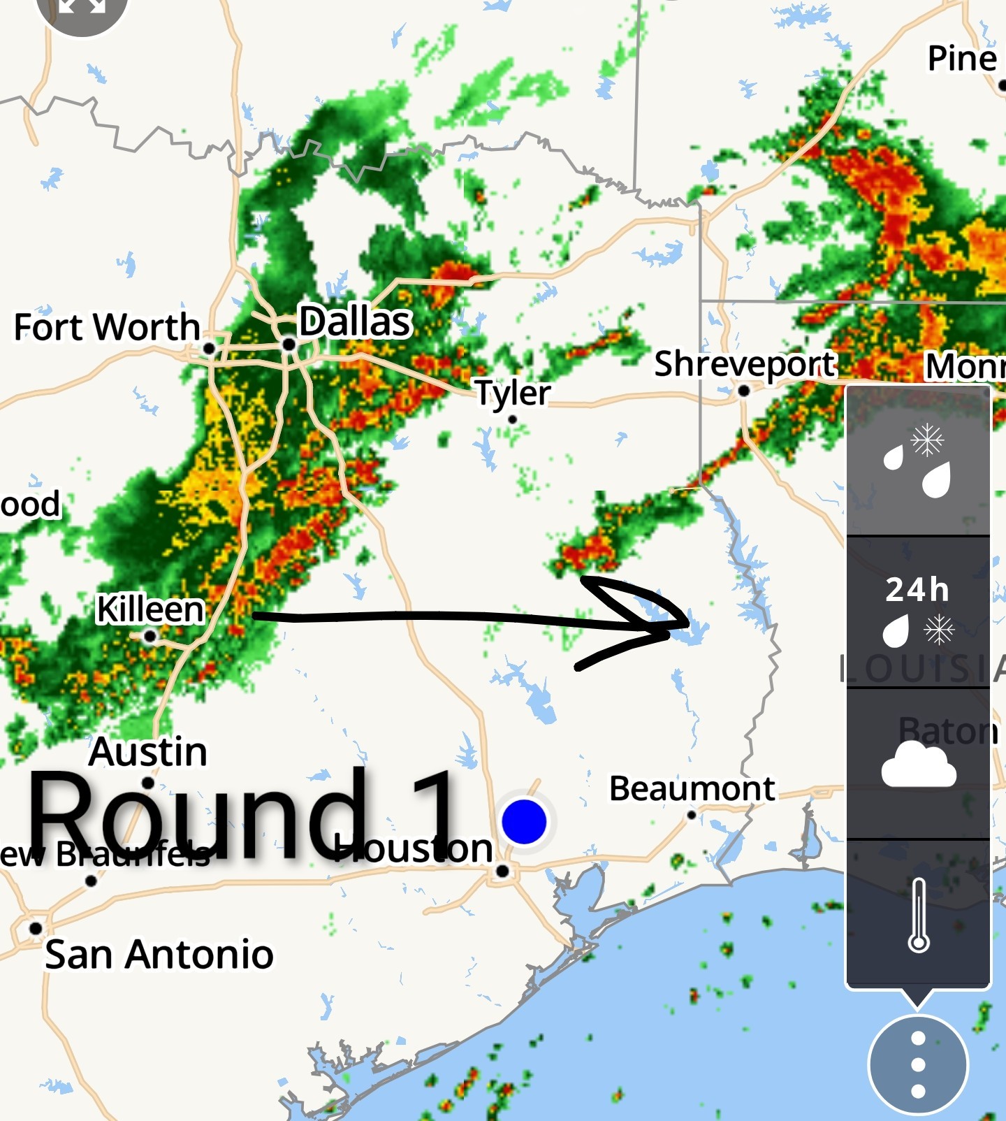 ➡️ Round 2: ~ 10AM-2PM future radar
  ➡️ Round 3: Line of storms with the front.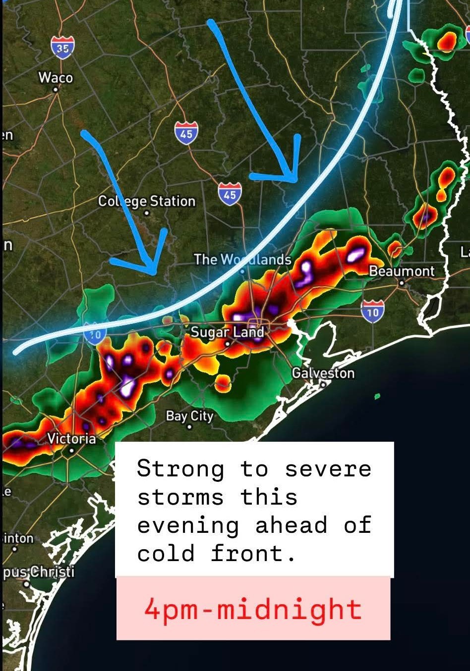
SteveT, peppermintstick and ZMAN + 1 more reacted « Back to Chat
Views: 810
# Replies: 24