


This week's forecast
This week's forecast


Joined:
X days ago
# Posts:
X,XXX
Contributor Points:
X


This week's forecast ➡️ Rain chances will be highest along the coast today (Monday) & Tuesday.
➡️ A cool front arrives Wednesday which increases our rain chances (into Thursday AM) and drops our daily low & high temps.
➡️ Weekend looks pleasant compared to the last few months with temps in the 60s/80s. ............. From Space City Weather: Finally, a hint of fall in the forecast for Houston. And maybe some rain, too. Eric Berger · Monday, September 22, 2025 6:56 AM In brief:
Today's post discusses an upcoming pattern change what will bring some rain midweek, and then some modestly cooler weather through the weekend. It won't feel like fall, precisely, but it won't be August-like either. Fall, finally? - It is fitting that the Autumnal equinox comes on Tuesday, when precisely at 1:19 pm CT the Sun will move directly over the equator. Why? Because some semblance of almost fall-like weather is on the way for the Houston region. The last 10 days, or so, have felt very much like late summer in the region with a string of daily high temperatures at Houston's official monitoring station hovering between 92 and 95 degrees. 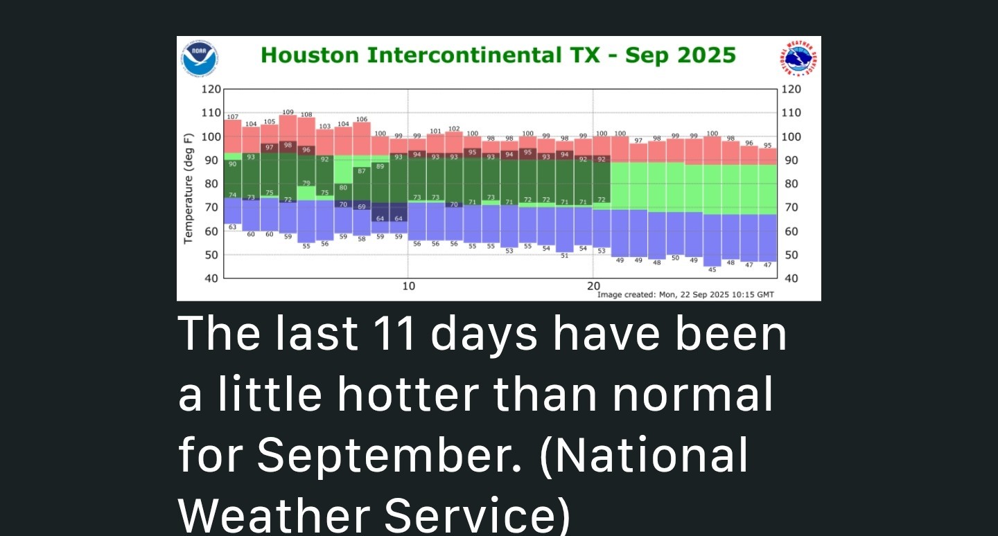 We have a couple of more warm-ish days before a weak front arrives mid-week. This won't bring that much cooler air-although it will bring some-but it will knock some of the humidity out of the lower atmosphere. As a result temperatures will feel a little more comfortable. We are likely to see more 90-degree days in the weeks ahead, but I don't think we are going to see any more prolonged stretches of highs in the low- to mid-90s. ................................ This week's forecast - MONDAY and TUESDAY - *These days should be similar, which is to say high temperatures generally in the vicinity of 90 degrees to the lower 90s, with plenty of humidity.
*Skies will be mostly sunny.
*Areas along and south of Interstate 10 have perhaps a 40 percent chance of seeing a passing shower or thunderstorm.
*Areas further inland probably have a somewhat less, but non-zero) chance.
*Winds will be modest, from the SSE with lows in the upper 70s. All in all, it will be pretty sticky outside. WEDNESDAY - *A cool front will approach the area on Wednesday. This combined with surging moisture levels in the atmosphere should produce widespread showers and thunderstorms.
*Most of the area probably will pick up 0.5 to 1.5 inches through the period of Thursday morning, but the majority of this rain probably will come on Wednesday and Wednesday evening.
*This will be another warm and humid day before some slightly drier air begins moving in over night. 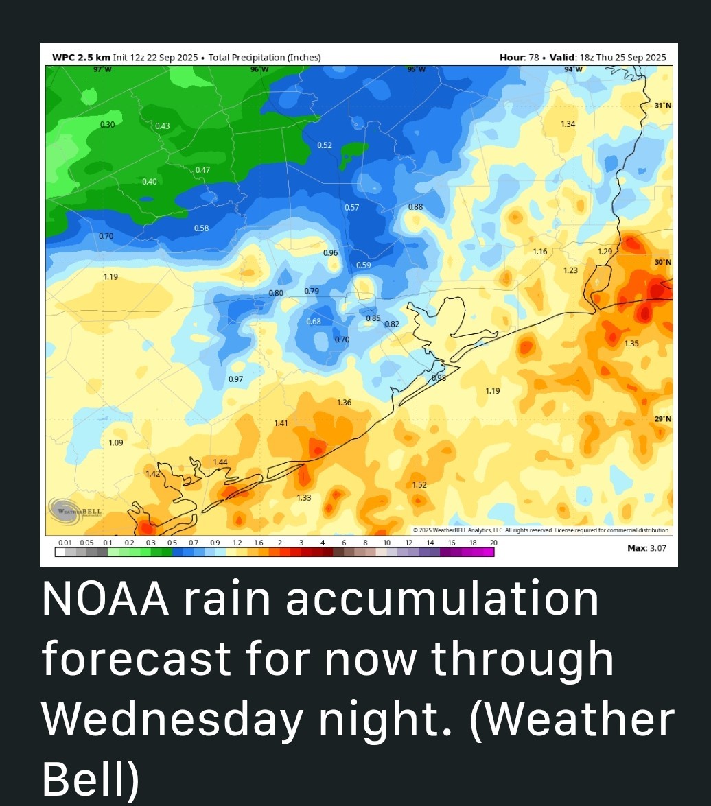 THURSDAY - *I think we'll see some lingering showers on Thursday morning as it will take some time for the front to amble off the coast.
*By the afternoon, we should see clearing skies and high in the upper 80s.
*Lows on Thursday night should drop into the 60s for all but areas near and along the coast. FRIDAY, SATURDAY, and SUNDAY - *We still have some questions about the details for this weekend because it's just not clear how much oomph the front will have.
*Skies this weekend should be mostly sunny with highs in the upper 80s to near 90 degrees with modest humidity.
*Nights will be a bit cooler, probably in the upper 60s.
*Some very slight rain chances likely return to the forecast on Sunday or Sunday evening.
*All in all, it looks like a warm, but fine weekend. NEXT WEEK - *Most of next week looks sunny with highs around 90 degrees and nights in the lower 70s.
*It's not exactly going to be summerlike in Houston, with slightly lower humidity levels, but it won't exactly feel like fall either.
*For me, it always feels like we're sitting in the cold front waiting room at this time of year.

CatalinaKitKat, cbear and peppermintstick reacted ➡️ A cool front arrives Wednesday which increases our rain chances (into Thursday AM) and drops our daily low & high temps.
➡️ Weekend looks pleasant compared to the last few months with temps in the 60s/80s.
Today's post discusses an upcoming pattern change what will bring some rain midweek, and then some modestly cooler weather through the weekend. It won't feel like fall, precisely, but it won't be August-like either.
*Skies will be mostly sunny.
*Areas along and south of Interstate 10 have perhaps a 40 percent chance of seeing a passing shower or thunderstorm.
*Areas further inland probably have a somewhat less, but non-zero) chance.
*Winds will be modest, from the SSE with lows in the upper 70s.
*Most of the area probably will pick up 0.5 to 1.5 inches through the period of Thursday morning, but the majority of this rain probably will come on Wednesday and Wednesday evening.
*This will be another warm and humid day before some slightly drier air begins moving in over night.
*By the afternoon, we should see clearing skies and high in the upper 80s.
*Lows on Thursday night should drop into the 60s for all but areas near and along the coast.
*Skies this weekend should be mostly sunny with highs in the upper 80s to near 90 degrees with modest humidity.
*Nights will be a bit cooler, probably in the upper 60s.
*Some very slight rain chances likely return to the forecast on Sunday or Sunday evening.
*All in all, it looks like a warm, but fine weekend.
*It's not exactly going to be summerlike in Houston, with slightly lower humidity levels, but it won't exactly feel like fall either.
*For me, it always feels like we're sitting in the cold front waiting room at this time of year.
Replies:

This week's forecast ➡️ Rain chances will be highest along the coast today (Monday) & Tuesday. ➡️ A cool front arrives Wednesday which increases our rain chances (into Thursday AM) and drops our daily low & high temps. ➡️ Weekend looks pleasant compared to the last few months with temps in the 60s/80s. ............. From Space City Weather: Finally, a hint of fall in the forecast for Houston. And maybe some rain, too. Eric Berger · Monday, September 22, 2025 6:56 AM In brief: Today's post discusses an upcoming pattern change what will bring some rain midweek, and then some modestly cooler weather through the weekend. It won't feel like fall, precisely, but it won't be August-like either. Fall, finally? - It is fitting that the Autumnal equinox comes on Tuesday, when precisely at 1:19 pm CT the Sun will move directly over the equator. Why? Because some semblance of almost fall-like weather is on the way for the Houston region. The last 10 days, or so, have felt very much like late summer in the region with a string of daily high temperatures at Houston's official monitoring station hovering between 92 and 95 degrees. We have a couple of more warm-ish days before a weak front arrives mid-week. This won't bring that much cooler air-although it will bring some-but it will knock some of the humidity out of the lower atmosphere. As a result temperatures will feel a little more comfortable. We are likely to see more 90-degree days in the weeks ahead, but I don't think we are going to see any more prolonged stretches of highs in the low- to mid-90s. ................................ This week's forecast - MONDAY and TUESDAY - *These days should be similar, which is to say high temperatures generally in the vicinity of 90 degrees to the lower 90s, with plenty of humidity. *Skies will be mostly sunny. *Areas along and south of Interstate 10 have perhaps a 40 percent chance of seeing a passing shower or thunderstorm. *Areas further inland probably have a somewhat less, but non-zero) chance. *Winds will be modest, from the SSE with lows in the upper 70s. All in all, it will be pretty sticky outside. WEDNESDAY - *A cool front will approach the area on Wednesday. This combined with surging moisture levels in the atmosphere should produce widespread showers and thunderstorms. *Most of the area probably will pick up 0.5 to 1.5 inches through the period of Thursday morning, but the majority of this rain probably will come on Wednesday and Wednesday evening. *This will be another warm and humid day before some slightly drier air begins moving in over night. THURSDAY - *I think we'll see some lingering showers on Thursday morning as it will take some time for the front to amble off the coast. *By the afternoon, we should see clearing skies and high in the upper 80s. *Lows on Thursday night should drop into the 60s for all but areas near and along the coast. FRIDAY, SATURDAY, and SUNDAY - *We still have some questions about the details for this weekend because it's just not clear how much oomph the front will have. *Skies this weekend should be mostly sunny with highs in the upper 80s to near 90 degrees with modest humidity. *Nights will be a bit cooler, probably in the upper 60s. *Some very slight rain chances likely return to the forecast on Sunday or Sunday evening. *All in all, it looks like a warm, but fine weekend. NEXT WEEK - *Most of next week looks sunny with highs around 90 degrees and nights in the lower 70s. *It's not exactly going to be summerlike in Houston, with slightly lower humidity levels, but it won't exactly feel like fall either. *For me, it always feels like we're sitting in the cold front waiting room at this time of year.
StormChaser : I am going to wait till the end of the week to cut grass when the mornings are a bit cooler. « Back to Chat
Views: 216
# Replies: 1