


This week's forecast
This week's forecast


Joined:
X days ago
# Posts:
X,XXX
Contributor Points:
X


This week's forecast From Space City Weather: TUESDAY - *Following widespread rainfall over the holiday weekend, showers this morning are mostly offshore after a weak front has moved into the area.
*I think we'll still see a slight chance of rain later this morning (30 percent, maybe) for areas along and south of Interstate 10, but the trend is clear as we are going to see an influx of moderately drier air over the next couple of days.
*Skies today should be mostly sunny with high temperatures in the vicinity of 90 degrees.
*Low temperatures tonight will drop into the mid 70s in the city, with slightly cooler temperatures possible for inland areas. 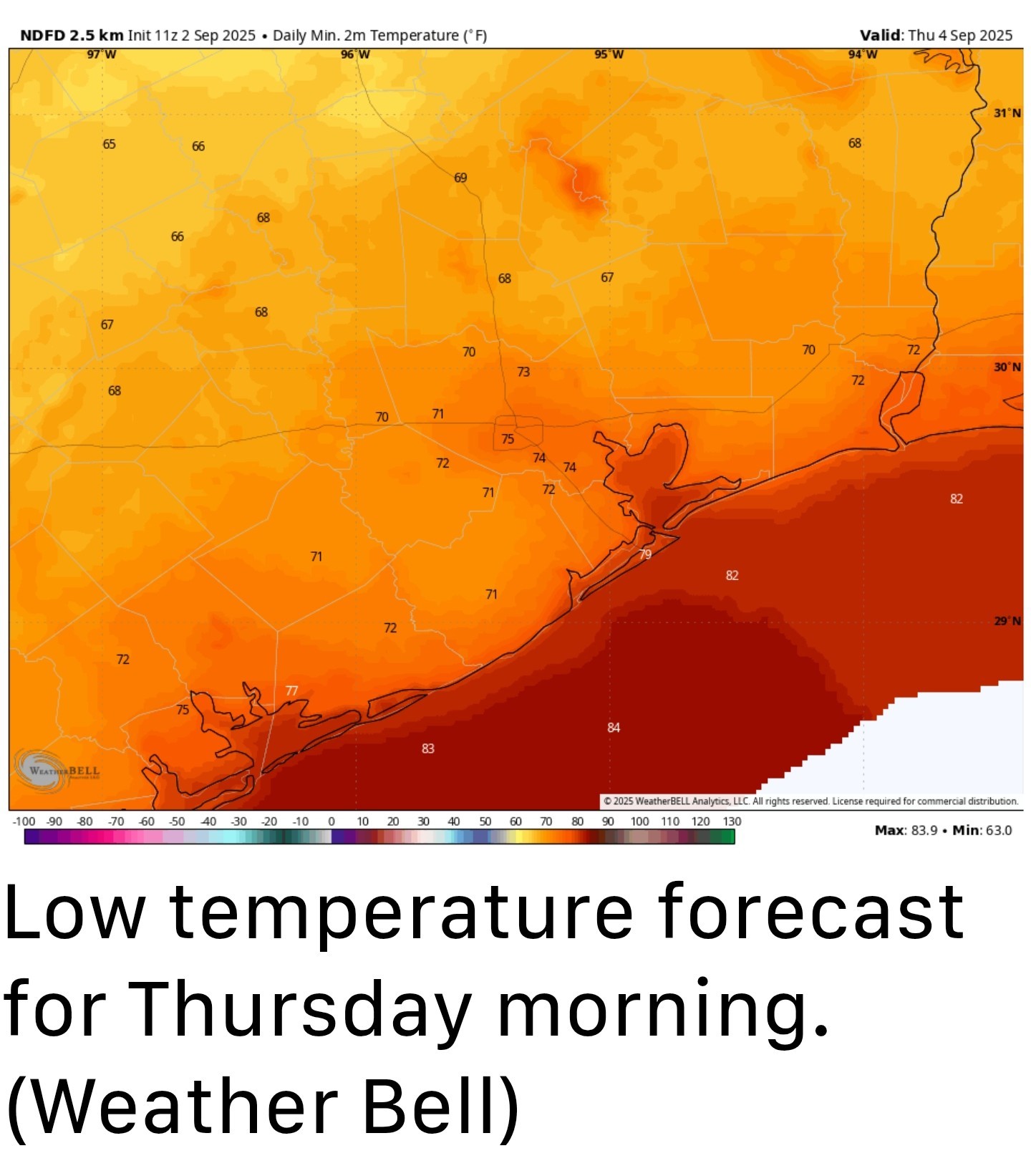 WEDNESDAY, THURSDAY, AND FRIDAY - *These will be the driest days, which in early September means there still will be some humidity.
*It should feel a little bit drier outside with highs likely reaching the lower 90s in Houston and mid-90s for some inland areas.
*Skies will be sunny, with virtually no chance of rain.
*I think Wednesday night into Thursday morning will see the "coolest" weather, with some inland locations potentially hitting the upper 60s.
*Obviously, this is not cold but the nights and mornings should feel a little bit more mild. SATURDAY, SUNDAY, AND BEYOND - *Some time on Friday, probably, the pattern will change as the onshore flow returns.
*This will raise humidity levels, should give us a warmer night on Friday, and start to increase rain chances this weekend.
*At the same time, another front will approach our area from the north. It is not entirely clear whether this front will push down into Houston and off the coast, or stall but the bottom line is that we probably will go from highs in the low 90s on Saturday to the upper 80s on Sunday and Monday.
*Decent rain chances (maybe 30 percent) on Saturday and better chances on Sunday into early next week.
*I don't think we'll see a repeat of the heavy rains we experienced over Labor Day weekend but I cannot be sure of that.
*Most of next week should see highs in the vicinity of 90 degrees. ............. A review of summer 2025 - August has come to an end. For most of us, in terms of weather at least, that is cause for celebration. Not because the kids are back in school, and teachers back at work. Not because summer vacation is over. But rather, because August is the hottest and most severe month for weather in Houston, and cooler conditions are on the horizon. September 1 also marks the start of meteorological fall, so it allows us to step back and ask, how hot was this summer? My immediate reaction is that this summer felt fairly mild. There were no prolonged periods of high pressure and blazingly hot days. However, when we dig a little deeper, we find a different answer. Matt already wrote about this in one of our monthly Q&A's, but this summer has been sneakily hot. When we look at the "average" temperature for June, July, and August of this year, we get a value of 86.0 degrees. This is simply the daily high, and daily low, divided by two for the last three months. It turns out this summer was the sixth hottest June, July, and August in nearly 150 years of Houston temperature records. 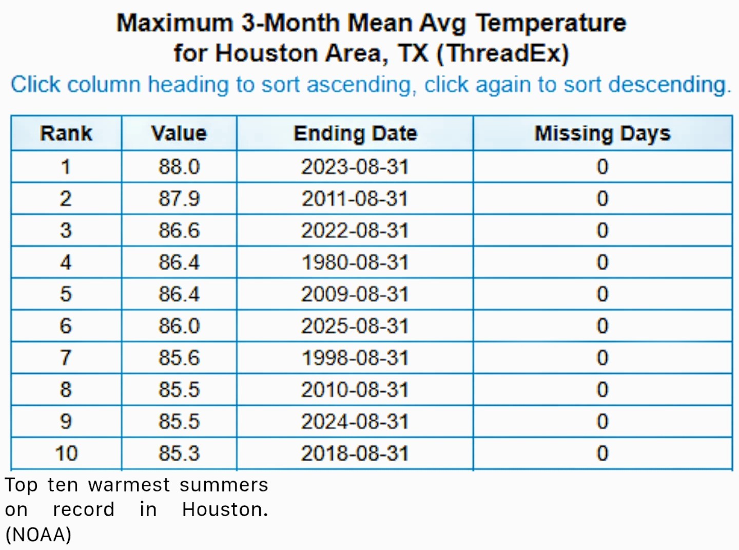 You might say, well, it did not feel that hot. And you're right, the days were not blistering hot. In terms of daily highs, our average of 94.9 degrees only ranked 12th on record in Houston. My sense is that summer days felt cooler because a) we had more clouds and periodic rainfall to help cool days off, and b) recent summers such as 2022 and 2023 were so incredibly hot that they have reset our expectations of normal. Where this summer was exceptionally hot, however, was at night, when the daily minimum temperature averaged 77.0 degrees. This is tied for second, all time, behind only 2023 (77.4 degrees). So what's going on here? Well, it's complicated. Certainly the urban heat island effect (widespread sprawl and concrete, which absorbs more heat) is playing a role. But Galveston and College Station also recorded summers that ranked in the top 10, in terms of overall heat. So there is more happening in the background here. The main driver of our warmer nights is the Gulf, which greatly influences our nighttime temperatures. This is due in no small part to warmer oceanic temperatures around the planet. Our world is heating up, and in Houston we are experiencing that even during a "mild" summer.


larpa, CatalinaKitKat and teatime + 5 more reacted *I think we'll still see a slight chance of rain later this morning (30 percent, maybe) for areas along and south of Interstate 10, but the trend is clear as we are going to see an influx of moderately drier air over the next couple of days.
*Skies today should be mostly sunny with high temperatures in the vicinity of 90 degrees.
*Low temperatures tonight will drop into the mid 70s in the city, with slightly cooler temperatures possible for inland areas.
*It should feel a little bit drier outside with highs likely reaching the lower 90s in Houston and mid-90s for some inland areas.
*Skies will be sunny, with virtually no chance of rain.
*I think Wednesday night into Thursday morning will see the "coolest" weather, with some inland locations potentially hitting the upper 60s.
*Obviously, this is not cold but the nights and mornings should feel a little bit more mild.
*This will raise humidity levels, should give us a warmer night on Friday, and start to increase rain chances this weekend.
*At the same time, another front will approach our area from the north. It is not entirely clear whether this front will push down into Houston and off the coast, or stall but the bottom line is that we probably will go from highs in the low 90s on Saturday to the upper 80s on Sunday and Monday.
*Decent rain chances (maybe 30 percent) on Saturday and better chances on Sunday into early next week.
*I don't think we'll see a repeat of the heavy rains we experienced over Labor Day weekend but I cannot be sure of that.
*Most of next week should see highs in the vicinity of 90 degrees.
Replies:
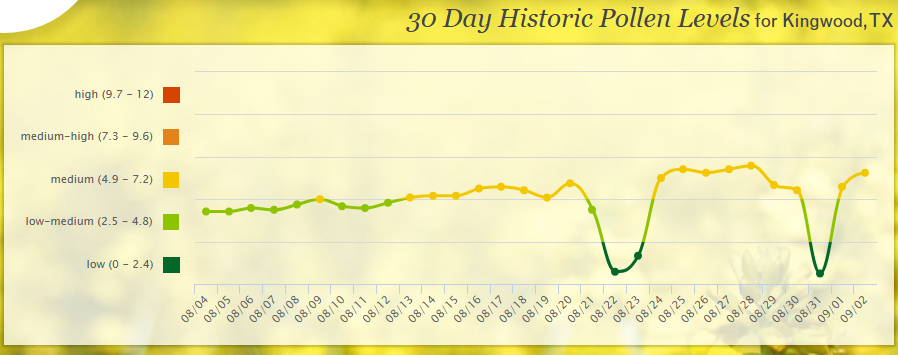
StormChaser: do you have access to reliable information about pollen counts in our area? I'd be interested in seeing what is in our air today. I'm sneezing like crazy today. Thanks
StormChaser: do you have access to reliable information about pollen counts in our area? I'd be interested in seeing what is in our air today. I'm sneezing like crazy today. Thanks
 Gammyof2 :
StormChaser: do you have access to reliable information about pollen counts in our area? I'd be interested in seeing what is in our air today. I'm sneezing like crazy today. Thanks
Gammyof2 : Here ya go! It looks like Mold spores are off the charts today. Slow4x4 also posted the chart.
Gammyof2 : Here ya go! It looks like Mold spores are off the charts today. And Slow4x4 also posted the chart. Houston Pollen and Mold Count - Tuesday, September 2, 2025 | Houston Health Department share.google/QcdQpkM fasDVUftfs
StormChaser : Oh boy. Everyone loves some mold and spores. 🤧 🤮
This week's forecast From Space City Weather: TUESDAY - *Following widespread rainfall over the holiday weekend, showers this morning are mostly offshore after a weak front has moved into the area.
*I think we'll still see a slight chance of rain later this morning (30 percent, maybe) for areas along and south of Interstate 10, but the trend is clear as we are going to see an influx of moderately drier air over the next couple of days.
*Skies today should be mostly sunny with high temperatures in the vicinity of 90 degrees.
*Low temperatures tonight will drop into the mid 70s in the city, with slightly cooler temperatures possible for inland areas. WEDNESDAY, THURSDAY, AND FRIDAY - *These will be the driest days, which in early September means there still will be some humidity.
*It should feel a little bit drier outside with highs likely reaching the lower 90s in Houston and mid-90s for some inland areas.
*Skies will be sunny, with virtually no chance of rain.
*I think Wednesday night into Thursday morning will see the "coolest" weather, with some inland locations potentially hitting the upper 60s.
*Obviously, this is not cold but the nights and mornings should feel a little bit more mild. SATURDAY, SUNDAY, AND BEYOND - *Some time on Friday, probably, the pattern will change as the onshore flow returns.
*This will raise humidity levels, should give us a warmer night on Friday, and start to increase rain chances this weekend.
*At the same time, another front will approach our area from the north. It is not entirely clear whether this front will push down into Houston and off the coast, or stall but the bottom line is that we probably will go from highs in the low 90s on Saturday to the upper 80s on Sunday and Monday.
*Decent rain chances (maybe 30 percent) on Saturday and better chances on Sunday into early next week.
*I don't think we'll see a repeat of the heavy rains we experienced over Labor Day weekend but I cannot be sure of that.
*Most of next week should see highs in the vicinity of 90 degrees. ............. A review of summer 2025 - August has come to an end. For most of us, in terms of weather at least, that is cause for celebration. Not because the kids are back in school, and teachers back at work. Not because summer vacation is over. But rather, because August is the hottest and most severe month for weather in Houston, and cooler conditions are on the horizon. September 1 also marks the start of meteorological fall, so it allows us to step back and ask, how hot was this summer? My immediate reaction is that this summer felt fairly mild. There were no prolonged periods of high pressure and blazingly hot days. However, when we dig a little deeper, we find a different answer. Matt already wrote about this in one of our monthly Q&A's, but this summer has been sneakily hot. When we look at the "average" temperature for June, July, and August of this year, we get a value of 86.0 degrees. This is simply the daily high, and daily low, divided by two for the last three months. It turns out this summer was the sixth hottest June, July, and August in nearly 150 years of Houston temperature records. You might say, well, it did not feel that hot. And you're right, the days were not blistering hot. In terms of daily highs, our average of 94.9 degrees only ranked 12th on record in Houston. My sense is that summer days felt cooler because a) we had more clouds and periodic rainfall to help cool days off, and b) recent summers such as 2022 and 2023 were so incredibly hot that they have reset our expectations of normal. Where this summer was exceptionally hot, however, was at night, when the daily minimum temperature averaged 77.0 degrees. This is tied for second, all time, behind only 2023 (77.4 degrees). So what's going on here? Well, it's complicated. Certainly the urban heat island effect (widespread sprawl and concrete, which absorbs more heat) is playing a role. But Galveston and College Station also recorded summers that ranked in the top 10, in terms of overall heat. So there is more happening in the background here. The main driver of our warmer nights is the Gulf, which greatly influences our nighttime temperatures. This is due in no small part to warmer oceanic temperatures around the planet. Our world is heating up, and in Houston we are experiencing that even during a "mild" summer.
*I think we'll still see a slight chance of rain later this morning (30 percent, maybe) for areas along and south of Interstate 10, but the trend is clear as we are going to see an influx of moderately drier air over the next couple of days.
*Skies today should be mostly sunny with high temperatures in the vicinity of 90 degrees.
*Low temperatures tonight will drop into the mid 70s in the city, with slightly cooler temperatures possible for inland areas.
*It should feel a little bit drier outside with highs likely reaching the lower 90s in Houston and mid-90s for some inland areas.
*Skies will be sunny, with virtually no chance of rain.
*I think Wednesday night into Thursday morning will see the "coolest" weather, with some inland locations potentially hitting the upper 60s.
*Obviously, this is not cold but the nights and mornings should feel a little bit more mild.
*This will raise humidity levels, should give us a warmer night on Friday, and start to increase rain chances this weekend.
*At the same time, another front will approach our area from the north. It is not entirely clear whether this front will push down into Houston and off the coast, or stall but the bottom line is that we probably will go from highs in the low 90s on Saturday to the upper 80s on Sunday and Monday.
*Decent rain chances (maybe 30 percent) on Saturday and better chances on Sunday into early next week.
*I don't think we'll see a repeat of the heavy rains we experienced over Labor Day weekend but I cannot be sure of that.
*Most of next week should see highs in the vicinity of 90 degrees.
 larpa tipped StormChaser 100 credits for a post in this forum discussion.
 « Back to Chat
Views: 525
# Replies: 5