


This week's forecast plus tropics update
This week's forecast plus tropics update


Joined:
X days ago
# Posts:
X,XXX
Contributor Points:
X


This week's forecast plus tropics update Taking stock of the Atlantic hurricane season as we enter crunch time. Eric Berger · Monday, August 18, 2025 7:11 AM In brief:
*In today's post we discuss our increasing rain chances for this week, with a wet period most likely from Thursday through Saturday.
*We also dig deep into an outlook for the rest of the Atlantic hurricane season as we have now entered "go" time for the season and Texas. "GO" TIME FOR THE TROPICS - *Over the weekend we saw Erin rapidly intensify, going from the Atlantic season's first hurricane to become a Category 5 storm within 24 hours.
*Fortunately, Erin remains unlikely to affect any landmasses as it follows a corridor between the North American coast and Bermuda.
*The rapid strengthening of Erin indicates that we've entered a new phase of the Atlantic season: prime time.
*For Texas, the next six weeks are by far the period we are most concerned about in terms of when, historically, the largest and most powerful storms have hit the state. 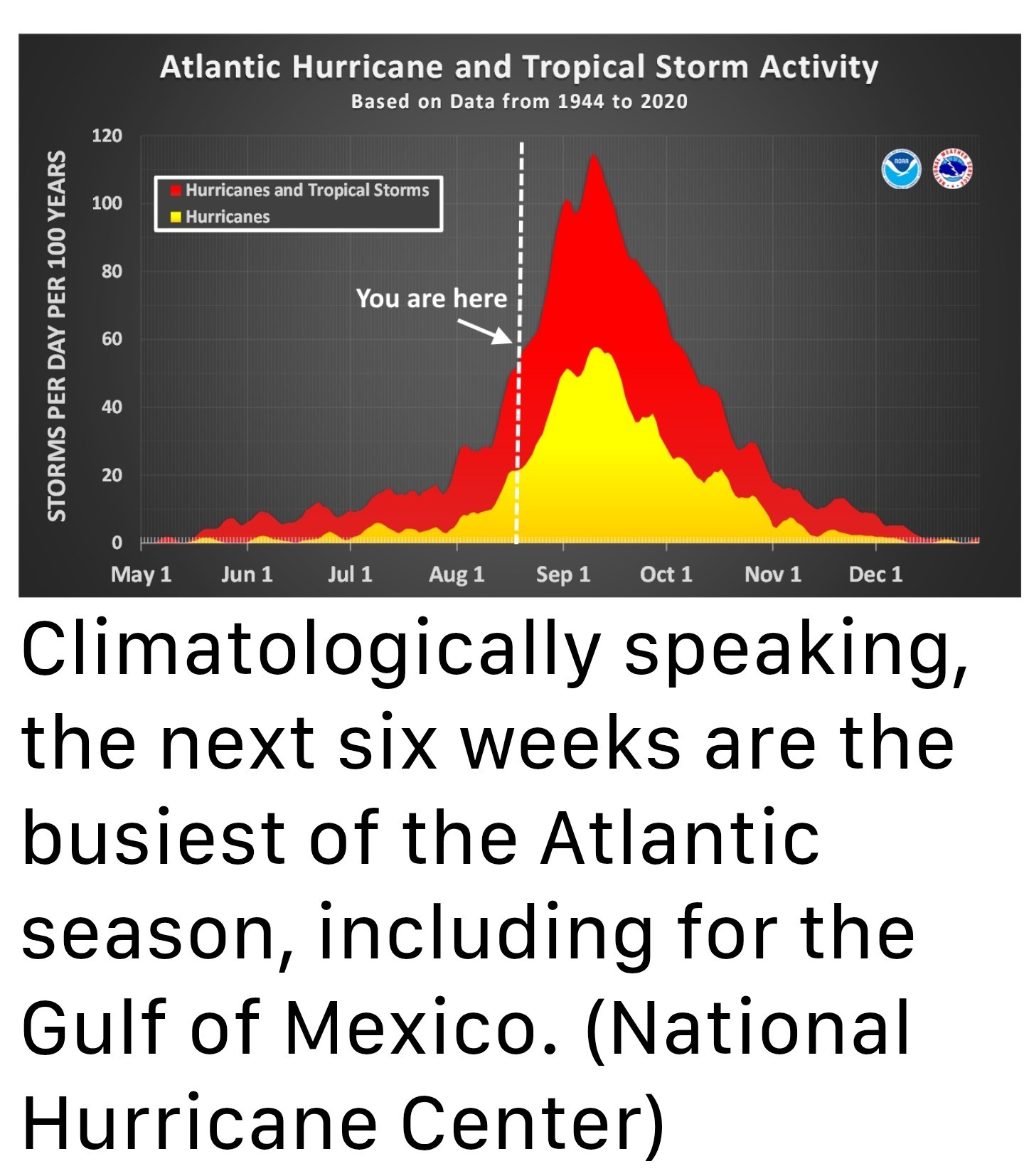 *Beyond Erin another tropical system is likely to form in the open Atlantic over the next couple of days. This storm should initialize further south than Erin did, giving it a better chance of approaching the Caribbean Sea, rather than skirting to its north.
*Although we cannot say anything definitive at this time, the majority of our model guidance has this system turning to the NORTH before reaching the Gulf 🤞perhaps following the same corridor as Erin, perhaps not. We will continue to watch it, of course. 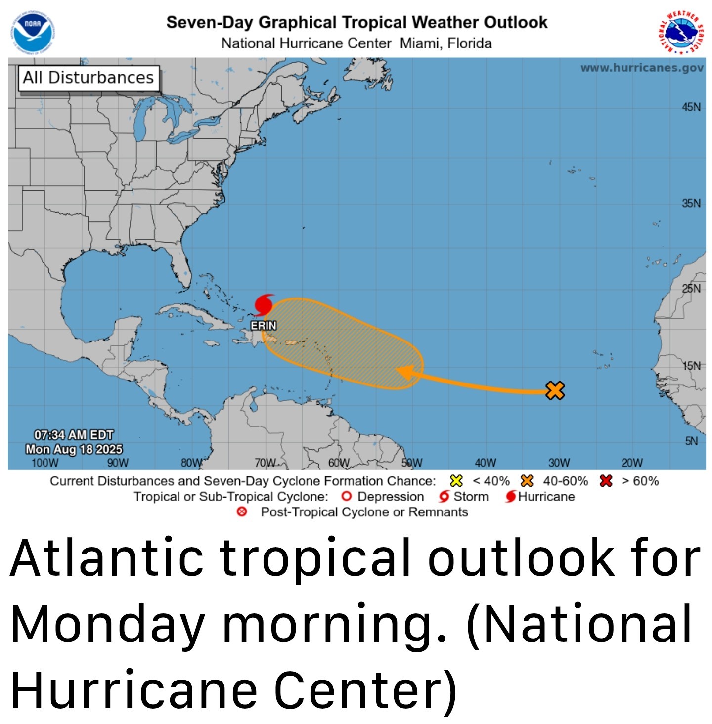 *The European forecast center (ECMWF) performs a weekly outlook forecast that looks ahead about a month. After a busy period through the end of August, it actually is forecasting a bit of a lull in Atlantic tropical activity (approximately 60 percent of normal levels) during the first week of September (see below) and 80 percent of normal levels during the second week.
*I would not take these weekly forecasts to the bank, but they beat the alternative of an extremely busy forecast. 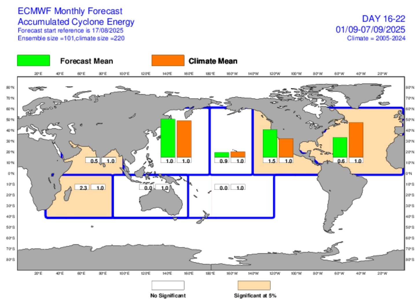 ➡️The bottom line is that, in Texas, we need to pay close attention to the tropics for the next six weeks. ➡️Although there are no immediate threats in the coming days, and the outlook for the remainder of August is fairly good, the tropics can always surprise us. As ever, Houston, be wary but not worried about the Atlantic tropics. ........................................... Now, let's jump into the weekly forecast. MONDAY - *Houston's high temperature peaked at 101 degrees on Sunday and the region saw virtually no rain showers. This offered a nice reminder of what August can do down here, but it also was probably the warmest day we are going to see this week.
*Monday should be quite hot again with widespread temperatures in the upper 90s due to sunny skies and high pressure in the vicinity.
*With that said, there is enough instability around to support the development of at least some scattered showers and thunderstorms later this afternoon, probably in the time range of 3 to 4 pm.
*Some of these storms, although isolated, could be fairly potent so if you have after school activities please be mindful of the potential for thunderstorms.
*Lows tonight will only drop to about 80 degrees. TUESDAY and WEDNESDAY - *High pressure will slowly retreat this week, and that will allow for improving rain chances and gradually lowering temperatures.
*Tuesday and Wednesday should both be solidly in the mid-90s for most locations however, with partly to mostly sunny skies.
*Each day will see about a 50 percent chance of showers (mostly during the afternoon) with a few isolated thunderstorms. 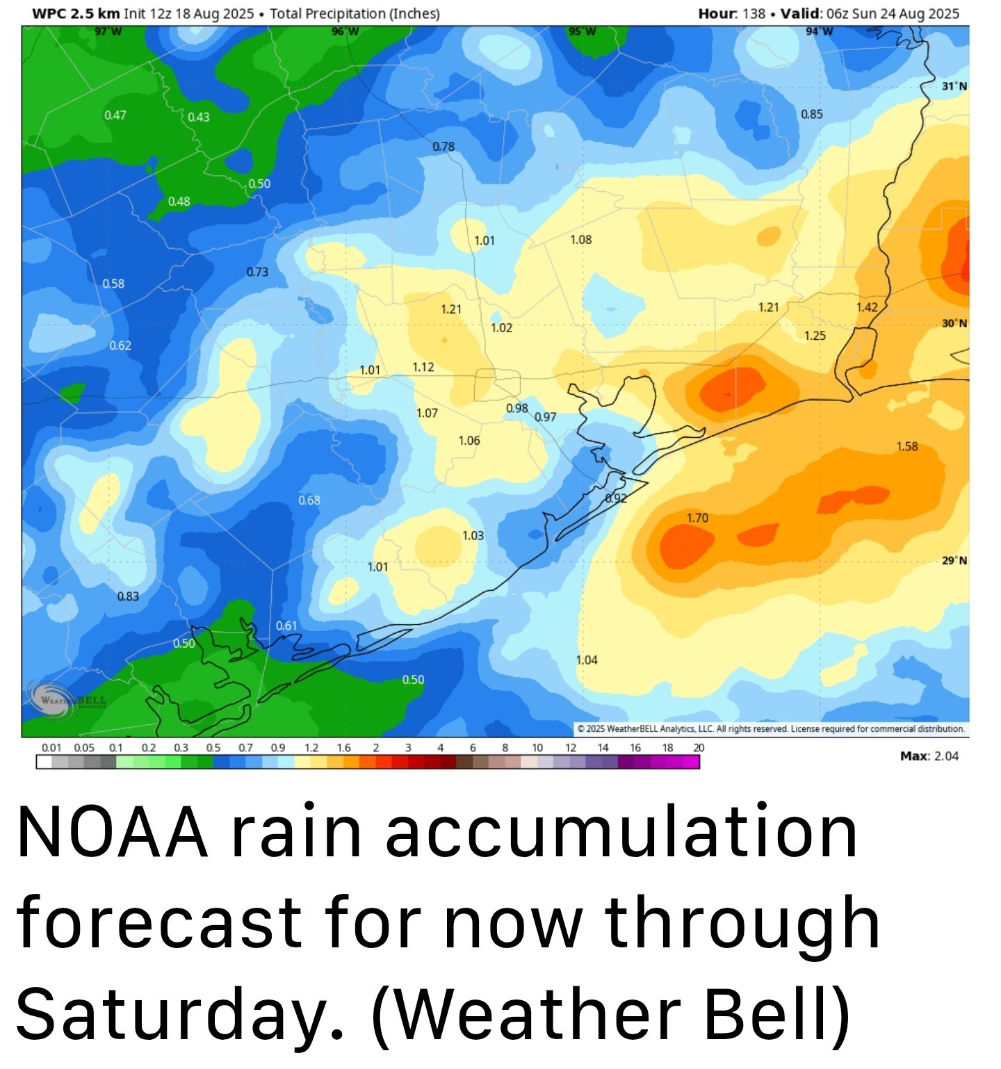 THURSDAY, FRIDAY, and SATURDAY - *This three-day period should see the best likelihood of rain, with chances generally from 50 to 70 percent daily.
*This should help drive high temperatures down to around 90 degrees, or just above, for much of the region.
*In terms of accumulation, I would expect much of the region to average about 1 inch of rain through Saturday, or so, but totals will be widely variable. We certainly could see some spotty flooding, but I'm not anticipating major, or widespread concerns.
*If you're planning outdoor activities, especially during the afternoon and evening hours, you'll need to watch the forecast closely. SUNDAY and BEYOND - *Rain chances will hang around in the forecast for Sunday and into next week, but they probably will begin to slacken some.
*With luck our high temperatures will remain in the low to mid 90s which is a pretty good way to end the month of August in H-town.

sebastian2, golfshot and Joe + 4 more reacted *In today's post we discuss our increasing rain chances for this week, with a wet period most likely from Thursday through Saturday.
*We also dig deep into an outlook for the rest of the Atlantic hurricane season as we have now entered "go" time for the season and Texas.
*Fortunately, Erin remains unlikely to affect any landmasses as it follows a corridor between the North American coast and Bermuda.
*The rapid strengthening of Erin indicates that we've entered a new phase of the Atlantic season: prime time.
*For Texas, the next six weeks are by far the period we are most concerned about in terms of when, historically, the largest and most powerful storms have hit the state.
*Although we cannot say anything definitive at this time, the majority of our model guidance has this system turning to the NORTH before reaching the Gulf 🤞perhaps following the same corridor as Erin, perhaps not.
*I would not take these weekly forecasts to the bank, but they beat the alternative of an extremely busy forecast.
*Monday should be quite hot again with widespread temperatures in the upper 90s due to sunny skies and high pressure in the vicinity.
*With that said, there is enough instability around to support the development of at least some scattered showers and thunderstorms later this afternoon, probably in the time range of 3 to 4 pm.
*Some of these storms, although isolated, could be fairly potent so if you have after school activities please be mindful of the potential for thunderstorms.
*Lows tonight will only drop to about 80 degrees.
*Tuesday and Wednesday should both be solidly in the mid-90s for most locations however, with partly to mostly sunny skies.
*Each day will see about a 50 percent chance of showers (mostly during the afternoon) with a few isolated thunderstorms.
*This should help drive high temperatures down to around 90 degrees, or just above, for much of the region.
*In terms of accumulation, I would expect much of the region to average about 1 inch of rain through Saturday, or so, but totals will be widely variable. We certainly could see some spotty flooding, but I'm not anticipating major, or widespread concerns.
*If you're planning outdoor activities, especially during the afternoon and evening hours, you'll need to watch the forecast closely.
*With luck our high temperatures will remain in the low to mid 90s which is a pretty good way to end the month of August in H-town.
Replies:
Good luck Y'all. I don't miss it and I feel for you
Labslady : I'm hoping these newer model runs that pull it north continue on that trend. « Back to Chat
Views: 413
# Replies: 2