


Friday Forecast + tropics update
Friday Forecast + tropics update


Joined:
X days ago
# Posts:
X,XXX
Contributor Points:
X


Friday Forecast + tropics update ✳️ Increased rain chances today & tomorrow.
✳️ Invest 98l will make "landfall" (for lack of a better term) in deep south Texas this evening as a tropical depression, at most.
✳️ Localized heavy rainfall possible today & tomorrow but this does not look to be a major flood threat to Houston because of the speed of the storm.
✳️ Not everyone in SE Texas will see rain. From Space City Weather - Gulf tropical disturbance to bring Houston an uptick in rain chances, followed by more typical August weather. Matt Lanza · Friday, August 15, 2025 7:12 AM In brief:
*Invest 98L, the Gulf tropical disturbance, will bring an enhanced chance of showers or storms to Houston today and Saturday, but nothing much more than that.
*After that exits, we maintain typical August weather with heat, humidity, and daily shower and storm chances. Today/Invest 98L - First off, let's get the elephant in the room taken care of: *Invest 98L, the tropical disturbance approaching the South Texas coast is becoming less likely to develop now, particularly because it's quickly running out of runway to work with.
*Odds remain 50% per the NHC, though if it does develop, it would be a tropical depression for about 3 to 6 hours or less before reaching land in South Texas. *That being said, it looks somewhat interesting on satellite this morning, conversationally at least. 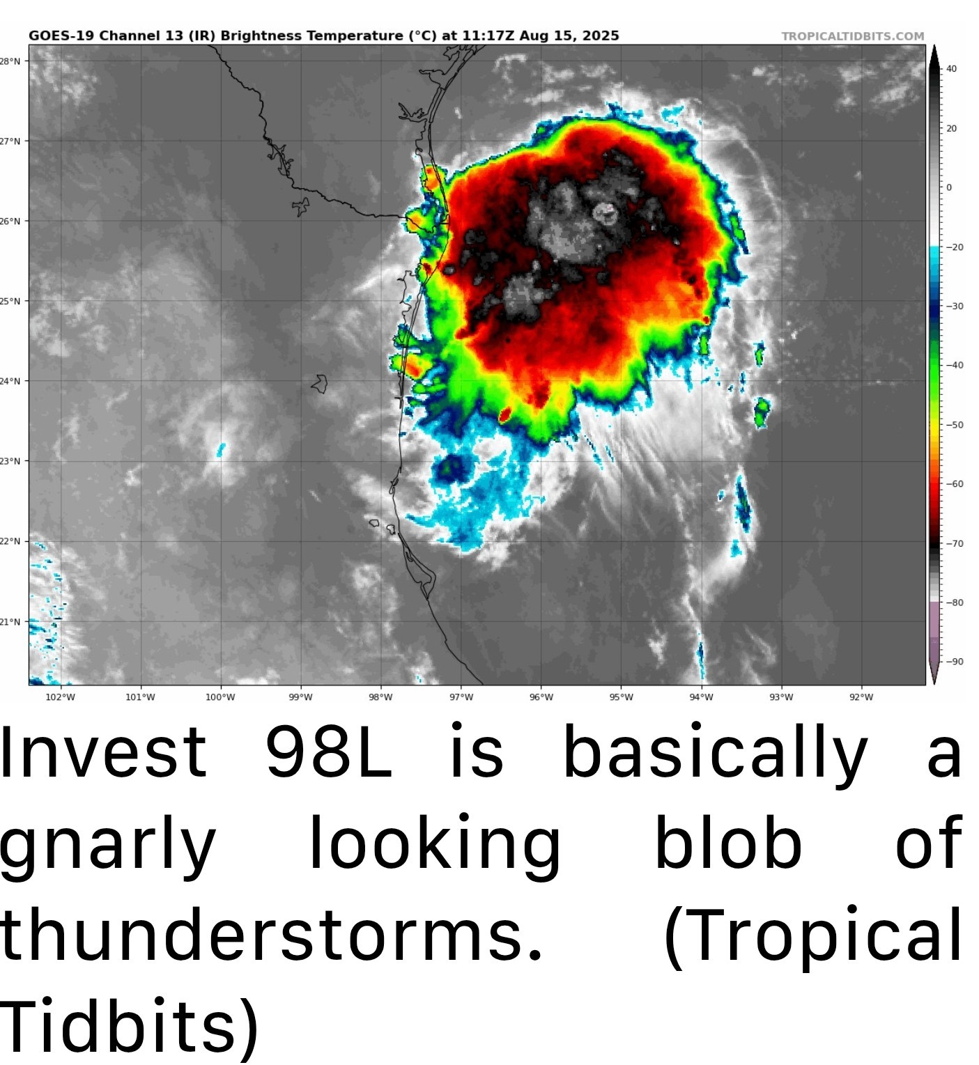 *This may look a little scary, but in reality, there is no low-level circulation so while there are some heavy thunderstorms and heavy rain underneath this blob of clouds, the system is not organizing much.
*So you can disregard any meaningful tropical development (wind, coastal flooding) elements of this for the most part. What we will watch for at least is rain. 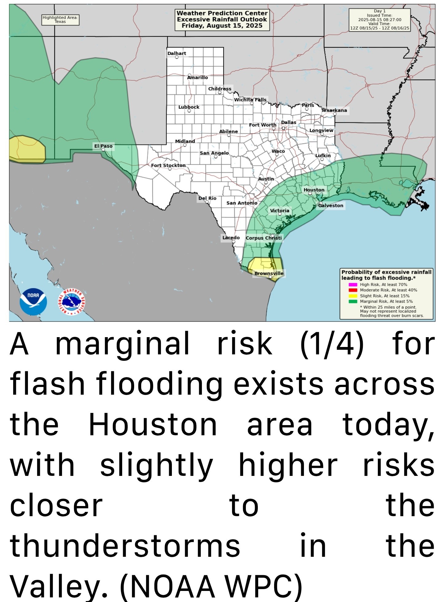 *We don't expect a ton of storms here today, but as this blob of storms lifts toward the coast, watch for development coinciding with daytime heating from Matagorda Bay up through Galveston, quickly moving inland.
*The one thing that will probably limit flooding is that storm motion today looks pretty quick. Unless we end up seeing several storms in a row over the same area, expect a few places to see perhaps an inch or two in less than an hour, some quick, minor street flooding, and then hopefully calmer weather. *It's possible that we also see a localized stronger storm with gusty winds as well. *Overall, the impacts of the tropical disturbance should be for a slightly more active August afternoon today. Even on slightly active days, some neighborhoods may not see any rain at all, so that's possible too.
*It's extremely humid outside this morning as some of that added moisture works into the area. We had some of our warmest overnight lows of summer in some parts of the region yesterday, and we'll be close to matching or exceeding them today (Jamaica Beach has not fallen below 86 degrees as of this writing for example). Saturday - *With the tropical disturbance dissolving inland, we'll be left with added moisture and onshore flow Saturday.
*For now, I'd say this is pretty typical August weather, but I wouldn't be entirely shocked to see a few repetitive thunderstorms that cause some minor street flooding tomorrow.
*Otherwise, just look for high humidity and warm to hot temperatures in the 90s. Sunday & Monday - *We should see relatively calm weather here, with just a continued slight chance of afternoon thunderstorms.
*Coverage should be a little less than it will be today and Saturday however.
*Highs in the mid-90s.


LittleTexas, peppermintstick and Rocketgirl13 + 5 more reacted ✳️ Invest 98l will make "landfall" (for lack of a better term) in deep south Texas this evening as a tropical depression, at most.
✳️ Localized heavy rainfall possible today & tomorrow but this does not look to be a major flood threat to Houston because of the speed of the storm.
✳️ Not everyone in SE Texas will see rain.
*Invest 98L, the Gulf tropical disturbance, will bring an enhanced chance of showers or storms to Houston today and Saturday, but nothing much more than that.
*After that exits, we maintain typical August weather with heat, humidity, and daily shower and storm chances.
*Odds remain 50% per the NHC, though if it does develop, it would be a tropical depression for about 3 to 6 hours or less before reaching land in South Texas.
*So you can disregard any meaningful tropical development (wind, coastal flooding) elements of this for the most part.
*The one thing that will probably limit flooding is that storm motion today looks pretty quick. Unless we end up seeing several storms in a row over the same area, expect a few places to see perhaps an inch or two in less than an hour, some quick, minor street flooding, and then hopefully calmer weather.
*It's extremely humid outside this morning as some of that added moisture works into the area. We had some of our warmest overnight lows of summer in some parts of the region yesterday, and we'll be close to matching or exceeding them today (Jamaica Beach has not fallen below 86 degrees as of this writing for example).
*For now, I'd say this is pretty typical August weather, but I wouldn't be entirely shocked to see a few repetitive thunderstorms that cause some minor street flooding tomorrow.
*Otherwise, just look for high humidity and warm to hot temperatures in the 90s.
*Coverage should be a little less than it will be today and Saturday however.
*Highs in the mid-90s.
Replies:
Im.going deep sea fishing tomorrow! This could make for a bumpy ride
Beaches, Quixote and teatime + 3 more reacted
I've never heard the term "Invest" used before!
What does that mean?
What does that mean?
I've never heard the term "Invest" used before! What does that mean?
luannski : short for investigation. Just an area they are looking at for possible development of a tropical depression or storm.
StormChaser : luannski : asasolid2r : TODAY!
cbear : look on the bright side, more clouds, won't hit 100 today or tomorrow, maybe.
StormChaser : Thanks for the update. I'm still hoping we'll get a decent shower from it.
cbear : look on the bright side, more clouds, won't hit 100 today or tomorrow, maybe.
asasolid2r : Right! It was 99 at Bush yesterday. I am soooo ready for a change. I detest "Uggust".
I've never heard the term "Invest" used before! What does that mean?
luannski :
luannski : Invest means its an area of interest designated by the NHS, so hurricane hunters and hurricane models will begin analyzing it. The 98 L refers to the body of water its in. The first one of the year starts at 91 and goes to 99, then it resets.
StormChaser : I just went to NHC and it was already been downgraded to 20%. « Back to Chat
Views: 511
# Replies: 10