


This week's forecast
This week's forecast


Joined:
X days ago
# Posts:
X,XXX
Contributor Points:
X


This week's forecast This week's forecast From Space City Weather. Congratulations, everyone. We've reached the hottest two weeks of the year. Eric Berger · Monday, July 28, 2025 7:05 AM In brief:
Today's post discusses the historical depths of summer, which occur over the next two weeks. However, while we will see considerable heat the next couple of days, increasing rain chances should help to take the edge off summer heat through the weekend. Depths of summer: Look, it can be really hot in Houston any time from April through October. And historically we have seen 100-degree weather as early as June 2, and as late as September 27. But the very warmest period of the year, based on climate statistics, comes from July 29 through August 12. This is when the region's high temperature averages 96 degrees. By August 13, the average high drops to 95 degrees, and by the end of the month we're down to 93 degrees. So we're here, at the peak of summer in Houston. And do you know what that means? If you squint, you can see fall in the distance. 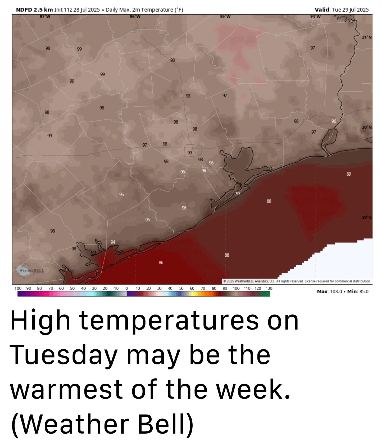 Monday - *After several rounds of showers over the weekend (which included some flooding just east of downtown Houston) our weather will now quiet down for a few days as high pressure builds over the area.
*We will see that in the form of sunny skies today with high temperatures in the upper 90s for inland areas and lower 90s for coastal areas.
*With that said, I would not entirely rule out of a few scattered to isolated showers later this afternoon or evening along the sea breeze.
*Winds will be light with lows tonight sultry and in the mid-70s. Tuesday - *This will probably be the hottest day of the week with sunny skies and high temperatures in the upper 90s for most of the region.
*However, dewpoints look to be slightly lower, so while the humidity will be high, it may not be oppressive.
*Rain chances are near zero. Expect another warm night in the mid-70s. Wednesday - *At this point I think high pressure will still largely influence our weather on Wednesday, so we can probably expect mostly sunny skies and highs mostly in the upper 90s.
*At the same time, we are going to see growing amounts of tropical moisture pooling to our east out over the Gulf, and this will bring higher rain chances during the second half of the week. So maybe we should splash in a low-end chance of a few showers. Thursday and Friday - *Skies will still probably be partly to mostly sunny to end the work week with high temperatures generally in the mid-90s.
*However, as low pressure (the risk of this becoming a tropical depression or tropical system is near zero, so we're not particularly concerned about that) drifts toward Texas across the Gulf, it will bring increased moisture levels into the coast and this will likely yield rain chances of about 30 to 50 percent for both days. 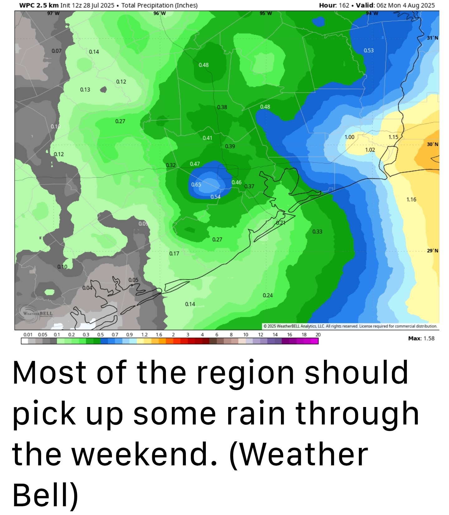 Saturday and Sunday - *We should remain in this pattern of elevated rain chances through the weekend, with a 50 percent likelihood of showers each day.
*At this point I don't expect the weekend to be a total washout, and there still should be periods of sunshine on both days.
*Temperatures should be a couple of degrees cooler (some areas may top out in the lower 90s).
*Overall, accumulations look fairly modest. Most of the area may see something on the order of 0.5 inch of rain but there probably will be higher bullseyes.
*All in all, for the peak of summer, it won't be terrible as Houston moves into August. Next week - I think we will see a continued chance of showers on Monday and perhaps Tuesday before things high pressure asserts a little more control next week. However, at this point I think we're likely to remain the 90s rather than pushing up into the 100s. Tropics - Things look very quiet out there for the next week or so, and quite possibly beyond. This is a great position to be in as we edge toward the month of August. Longtime residents will know that the next two months are, traditionally, "go time" for Texas and the tropics. So we will be watching things very closely.


RolloTomaso, golfshot and buffaloglenn + 6 more reacted Today's post discusses the historical depths of summer, which occur over the next two weeks. However, while we will see considerable heat the next couple of days, increasing rain chances should help to take the edge off summer heat through the weekend.
*We will see that in the form of sunny skies today with high temperatures in the upper 90s for inland areas and lower 90s for coastal areas.
*With that said, I would not entirely rule out of a few scattered to isolated showers later this afternoon or evening along the sea breeze.
*Winds will be light with lows tonight sultry and in the mid-70s.
*However, dewpoints look to be slightly lower, so while the humidity will be high, it may not be oppressive.
*Rain chances are near zero. Expect another warm night in the mid-70s.
*At the same time, we are going to see growing amounts of tropical moisture pooling to our east out over the Gulf, and this will bring higher rain chances during the second half of the week. So maybe we should splash in a low-end chance of a few showers.
*However, as low pressure (the risk of this becoming a tropical depression or tropical system is near zero, so we're not particularly concerned about that) drifts toward Texas across the Gulf, it will bring increased moisture levels into the coast and this will likely yield rain chances of about 30 to 50 percent for both days.
*At this point I don't expect the weekend to be a total washout, and there still should be periods of sunshine on both days.
*Temperatures should be a couple of degrees cooler (some areas may top out in the lower 90s).
*Overall, accumulations look fairly modest. Most of the area may see something on the order of 0.5 inch of rain but there probably will be higher bullseyes.
*All in all, for the peak of summer, it won't be terrible as Houston moves into August.
Replies:
This week's forecast This week's forecast From Space City Weather. Congratulations, everyone. We've reached the hottest two weeks of the year. Eric Berger · Monday, July 28, 2025 7:05 AM In brief: Today's post discusses the historical depths of summer, which occur over the next two weeks. However, while we will see considerable heat the next couple of days, increasing rain chances should help to take the edge off summer heat through the weekend. Depths of summer: Look, it can be really hot in Houston any time from April through October. And historically we have seen 100-degree weather as early as June 2, and as late as September 27. But the very warmest period of the year, based on climate statistics, comes from July 29 through August 12. This is when the region's high temperature averages 96 degrees. By August 13, the average high drops to 95 degrees, and by the end of the month we're down to 93 degrees. So we're here, at the peak of summer in Houston. And do you know what that means? If you squint, you can see fall in the distance. Monday - *After several rounds of showers over the weekend (which included some flooding just east of downtown Houston) our weather will now quiet down for a few days as high pressure builds over the area. *We will see that in the form of sunny skies today with high temperatures in the upper 90s for inland areas and lower 90s for coastal areas. *With that said, I would not entirely rule out of a few scattered to isolated showers later this afternoon or evening along the sea breeze. *Winds will be light with lows tonight sultry and in the mid-70s. Tuesday - *This will probably be the hottest day of the week with sunny skies and high temperatures in the upper 90s for most of the region. *However, dewpoints look to be slightly lower, so while the humidity will be high, it may not be oppressive. *Rain chances are near zero. Expect another warm night in the mid-70s. Wednesday - *At this point I think high pressure will still largely influence our weather on Wednesday, so we can probably expect mostly sunny skies and highs mostly in the upper 90s. *At the same time, we are going to see growing amounts of tropical moisture pooling to our east out over the Gulf, and this will bring higher rain chances during the second half of the week. So maybe we should splash in a low-end chance of a few showers. Thursday and Friday - *Skies will still probably be partly to mostly sunny to end the work week with high temperatures generally in the mid-90s. *However, as low pressure (the risk of this becoming a tropical depression or tropical system is near zero, so we're not particularly concerned about that) drifts toward Texas across the Gulf, it will bring increased moisture levels into the coast and this will likely yield rain chances of about 30 to 50 percent for both days. Saturday and Sunday - *We should remain in this pattern of elevated rain chances through the weekend, with a 50 percent likelihood of showers each day. *At this point I don't expect the weekend to be a total washout, and there still should be periods of sunshine on both days. *Temperatures should be a couple of degrees cooler (some areas may top out in the lower 90s). *Overall, accumulations look fairly modest. Most of the area may see something on the order of 0.5 inch of rain but there probably will be higher bullseyes. *All in all, for the peak of summer, it won't be terrible as Houston moves into August. Next week - I think we will see a continued chance of showers on Monday and perhaps Tuesday before things high pressure asserts a little more control next week. However, at this point I think we're likely to remain the 90s rather than pushing up into the 100s. Tropics - Things look very quiet out there for the next week or so, and quite possibly beyond. This is a great position to be in as we edge toward the month of August. Longtime residents will know that the next two months are, traditionally, "go time" for Texas and the tropics. So we will be watching things very closely.
StormChaser : Thanks. I need to pay close attention to the forecast to target the "least miserable" time to mow before the weekend rains!
StormChaser : I need to pay close attention to the forecast to target the "least miserable" time to mow
cbear : December lol.
 StormChaser :
 Thanks for the forecast. Not looking forward to the hotter part.
Thankful the tropics are quiet.




« Back to Chat
Views: 530
# Replies: 6