


This week's forecast
This week's forecast


Joined:
X days ago
# Posts:
X,XXX
Contributor Points:
X


This week's forecast This week's forecast: 🔥🔥🔥 From Space City Weather - A mostly quiet week, with building heat as we approach the peak of summer in Houston. Matt Lanza · Monday, July 21, 2025 6:55 AM In brief:
*As we approach our typical peak of summer heat, we'll be seeing an uptick in temperatures through the week.
*We should see potentially upper 90s to near 100 in spots by late week before some shower chances re-enter the forecast. Even hotter weather is possible next week. *Houston's summer heat typically peaks between July 29th and August 12th, when our average high temperatures sits at 96° and our average low temperature is 76 degrees.
*The actual peak date is probably around August 5th - so we are nearing the top of the mountain - and this week may prove to include our hottest weather of summer. 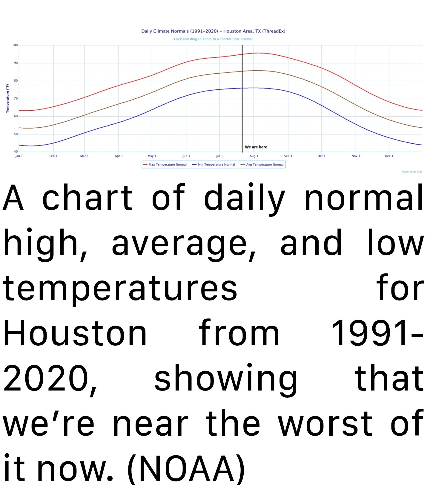 TODAY THROUGH WEDNESDAY - *We will start the week with heat and humidity that slowly builds.
*Highs will push into the mid and perhaps upper 90s by midweek.
*Thunderstorm chances, while not quite zero each day are fairly low.
*Morning lows are likely to be in the upper 70s. THURSDAY AND FRIDAY - *I have a feeling that Thursday may be the hottest day of the week.
*If not, then it will likely be Friday. 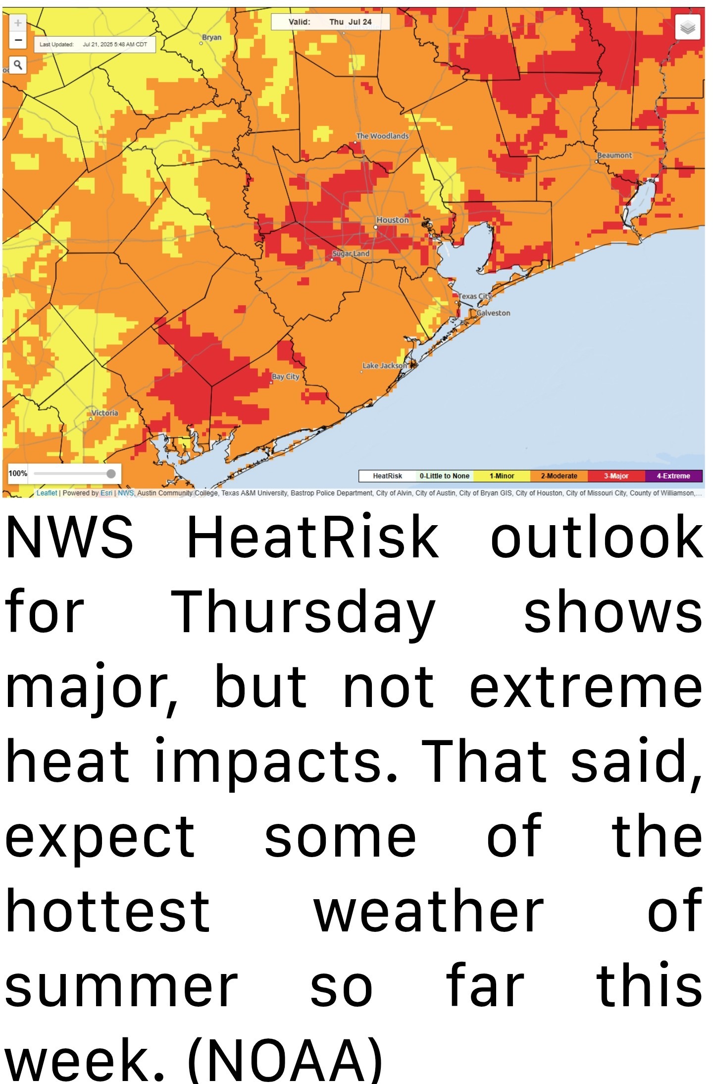 *The National Weather Service's experimental HeatRisk product puts our area in high risk on both days, with a strong edge to Thursday right now.
*Either way, expect some of the hottest weather of summer so far this week. 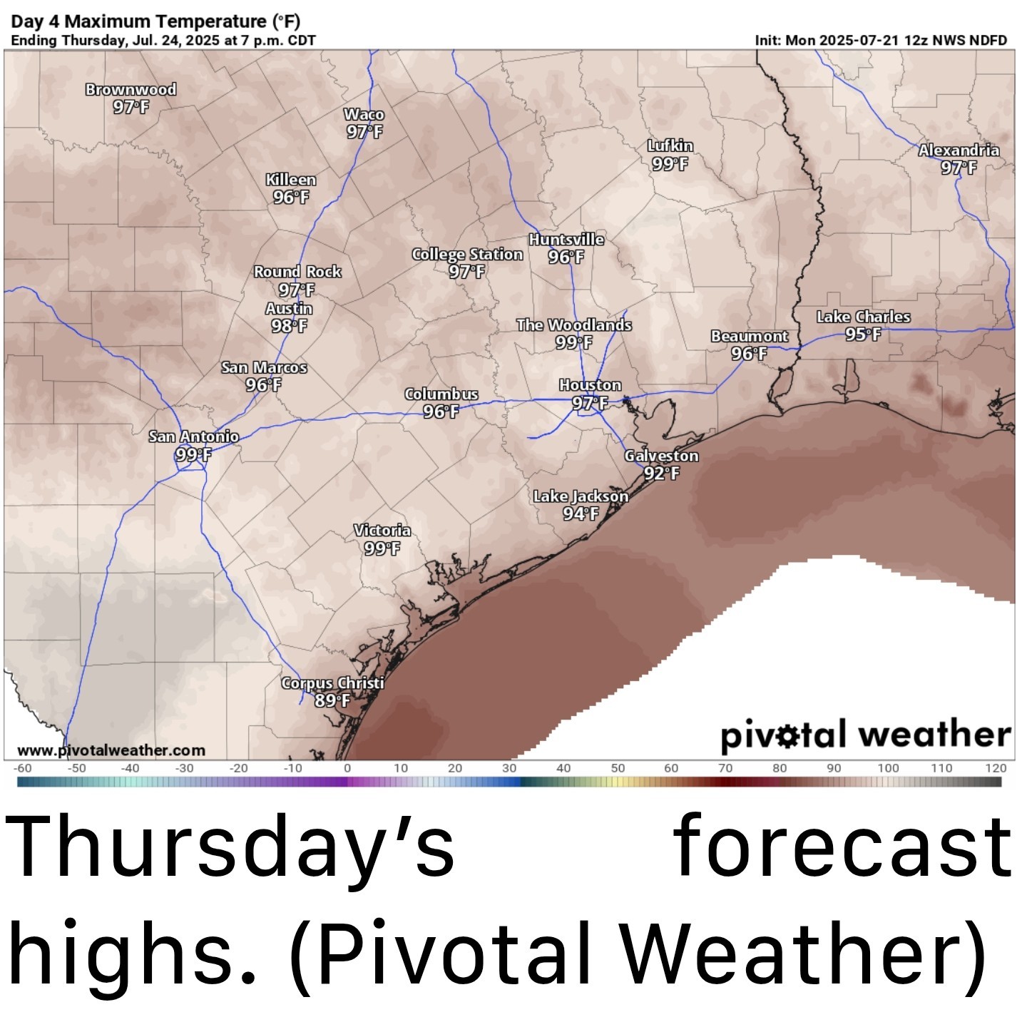 *By the time we get to Friday, we may see showers or thunderstorms re-enter the forecast, depending on the track of a tropical wave in the Gulf.
*No development is expected, but a similar track to last week's Invest 93L is possible, which could keep most of the rain to our east again - or a somewhat more southerly track could bring higher rain chances to our area by Friday.
*Something we'll watch through the week but the main takeaway here is that, again, no development is expected. WEEKEND AND BEYOND - *Once that wave passes, we should sort of resume a typical summer pattern of heat, humidity, and slight daily storm chances in the area.
*It does appear that a very strong ridge of high pressure in the upper atmosphere is going to establish over the Southern Plains next week.
*We may be on the periphery of it enough to get continued shower chances each afternoon, but if this flexes much further, we may see even hotter weather next week, perhaps the hottest of summer. Stay tuned -

*As we approach our typical peak of summer heat, we'll be seeing an uptick in temperatures through the week.
*We should see potentially upper 90s to near 100 in spots by late week before some shower chances re-enter the forecast.
*The actual peak date is probably around August 5th - so we are nearing the top of the mountain - and this week may prove to include our hottest weather of summer.
*Highs will push into the mid and perhaps upper 90s by midweek.
*Thunderstorm chances, while not quite zero each day are fairly low.
*Morning lows are likely to be in the upper 70s.
*If not, then it will likely be Friday.
*Either way, expect some of the hottest weather of summer so far this week.
*No development is expected, but a similar track to last week's Invest 93L is possible, which could keep most of the rain to our east again - or a somewhat more southerly track could bring higher rain chances to our area by Friday.
*Something we'll watch through the week but the main takeaway here is that, again, no development is expected.
*It does appear that a very strong ridge of high pressure in the upper atmosphere is going to establish over the Southern Plains next week.
*We may be on the periphery of it enough to get continued shower chances each afternoon, but if this flexes much further, we may see even hotter weather next week, perhaps the hottest of summer.