


This week's forecast
This week's forecast


Joined:
X days ago
# Posts:
X,XXX
Contributor Points:
X


This week's forecast From Space City Weather -- MONDAY -- *As we saw on Sunday, Houston's atmosphere is a little more open to rainfall with high pressure having departed the region.
*That pattern will continue today, with rain chances of perhaps about 30 percent.
*To go along with this, we will see partly to mostly sunny skies and high temperatures in the low- to mid-90s.
*Afternoon winds will peak at about 10 mph from the southeast, with higher gusts.
*Lows tonight will drop into the upper 70s. TUESDAY and WEDNESDAY -- *The middle of the week should have the best rain chances, with probably at least half the area receiving rainfall each day.
*These will be the kinds of storms where some parts of Houston quickly pick up 1 or possibly 2 inches of rainfall, and many other areas see on the order of a tenth of an inch, or two.
*In other words, they will be hit or miss, and it's not really possible to forecast right now where the heaviest rains will be.
*Highs both days will likely be in the lower 90s, with partly sunny skies. 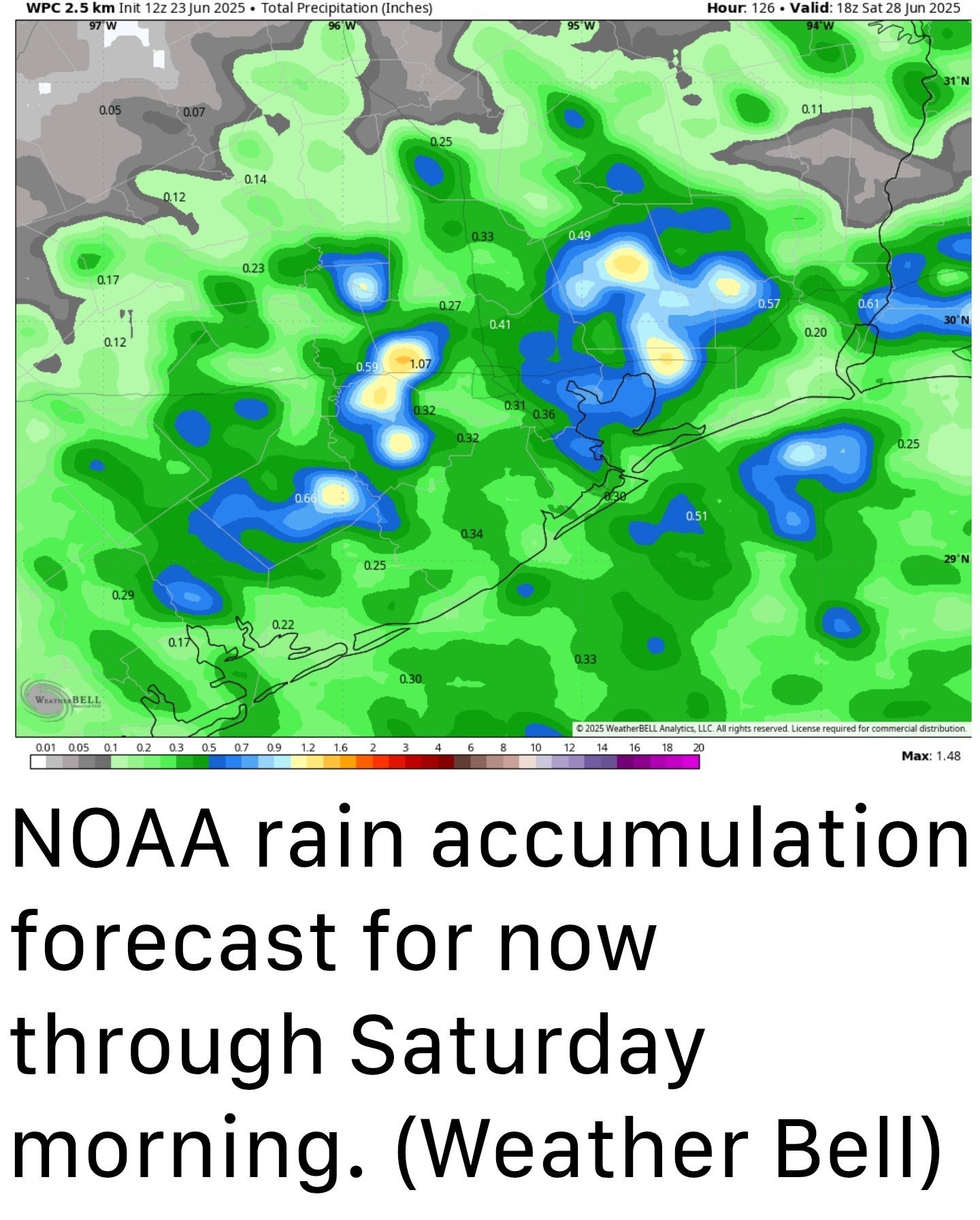 THURSDAY and FRIDAY -- *Rain chances will drop back to about 30 percent, daily, to end the work week as our atmosphere becomes a little bit more stable.
*As a result expect mostly sunny skies and warmer temperatures, with highs in the low- to mid-90s.
*Nights remain warm and humid, of course. SATURDAY, SUNDAY, and BEYOND -- *Saturday's weather probably will be a continuation of what we experience on Thursday and Friday, but by Sunday rain chances may be on the upswing again.
*At this point my expectations for Sunday into next week are ongoing daily rain chances in the vicinity of 30 to 50 percent each day, with highs in the lower-to-mid 90s.
*In other words, this pattern of fairly typical late June weather may well continue into early July.

*That pattern will continue today, with rain chances of perhaps about 30 percent.
*To go along with this, we will see partly to mostly sunny skies and high temperatures in the low- to mid-90s.
*Afternoon winds will peak at about 10 mph from the southeast, with higher gusts.
*Lows tonight will drop into the upper 70s.
*These will be the kinds of storms where some parts of Houston quickly pick up 1 or possibly 2 inches of rainfall, and many other areas see on the order of a tenth of an inch, or two.
*In other words, they will be hit or miss, and it's not really possible to forecast right now where the heaviest rains will be.
*Highs both days will likely be in the lower 90s, with partly sunny skies.
*As a result expect mostly sunny skies and warmer temperatures, with highs in the low- to mid-90s.
*Nights remain warm and humid, of course.
*At this point my expectations for Sunday into next week are ongoing daily rain chances in the vicinity of 30 to 50 percent each day, with highs in the lower-to-mid 90s.
*In other words, this pattern of fairly typical late June weather may well continue into early July.
Replies:
This week's forecast From Space City Weather -- MONDAY -- *As we saw on Sunday, Houston's atmosphere is a little more open to rainfall with high pressure having departed the region. *That pattern will continue today, with rain chances of perhaps about 30 percent. *To go along with this, we will see partly to mostly sunny skies and high temperatures in the low- to mid-90s. *Afternoon winds will peak at about 10 mph from the southeast, with higher gusts. *Lows tonight will drop into the upper 70s. TUESDAY and WEDNESDAY -- *The middle of the week should have the best rain chances, with probably at least half the area receiving rainfall each day. *These will be the kinds of storms where some parts of Houston quickly pick up 1 or possibly 2 inches of rainfall, and many other areas see on the order of a tenth of an inch, or two. *In other words, they will be hit or miss, and it's not really possible to forecast right now where the heaviest rains will be. *Highs both days will likely be in the lower 90s, with partly sunny skies. THURSDAY and FRIDAY -- *Rain chances will drop back to about 30 percent, daily, to end the work week as our atmosphere becomes a little bit more stable. *As a result expect mostly sunny skies and warmer temperatures, with highs in the low- to mid-90s. *Nights remain warm and humid, of course. SATURDAY, SUNDAY, and BEYOND -- *Saturday's weather probably will be a continuation of what we experience on Thursday and Friday, but by Sunday rain chances may be on the upswing again. *At this point my expectations for Sunday into next week are ongoing daily rain chances in the vicinity of 30 to 50 percent each day, with highs in the lower-to-mid 90s. *In other words, this pattern of fairly typical late June weather may well continue into early July.
StormChaser : Thanks. I really hope we have a more "normal" Summer with normal amounts of precip. Beryl is still too fresh in peoples minds. « Back to Chat
Views: 1,596
# Replies: 1