


Weekend forecast + hurricane season update
Weekend forecast + hurricane season update


Joined:
X days ago
# Posts:
X,XXX
Contributor Points:
X


Weekend forecast + hurricane season update Forecast for today, this weekend & next week + an update on hurricane season so far - From Space City Weather - Wetter weather returns to Houston next week, and we take a peek at the quiet hurricane season start so far. Matt Lanza · Friday, June 20, 2025 7:33 AM In brief:
*Mostly minimal shower and storm coverage this weekend in Houston will increase by a good bit next week.
*Additionally, we take a look at why this hurricane season has started quieter than most recent ones. TODAY -- *We had a slightly higher coverage of showers yesterday than we did Wednesday, and today should be fairly similar.
*Most of us will stay dry but some areas could see up to an inch of rain or so in a cooling downpour.
*We hit 95 yesterday officially, and we should make a run for that again today. WEEKEND -- *The coverage of showers may actually decrease some this weekend.
*Both Saturday and Sunday carry something like a 15 to 20 percent chance of a shower.
*That doesn't mean it won't rain, but it does mean the odds aren't high!
*Sunday probably carries a slight edge over Saturday in terms of higher shower coverage.
*Temperatures will be steady with low to mid 90s for highs and mid to upper 70s for lows away from the coast, with low 80s at the coast. NEXT WEEK -- *While this week was pretty quiet after Monday, next week should be a bit busier each day.
*We'll probably carry 30 to 40 percent or even higher rain chances each afternoon, with pop up thunderstorms. 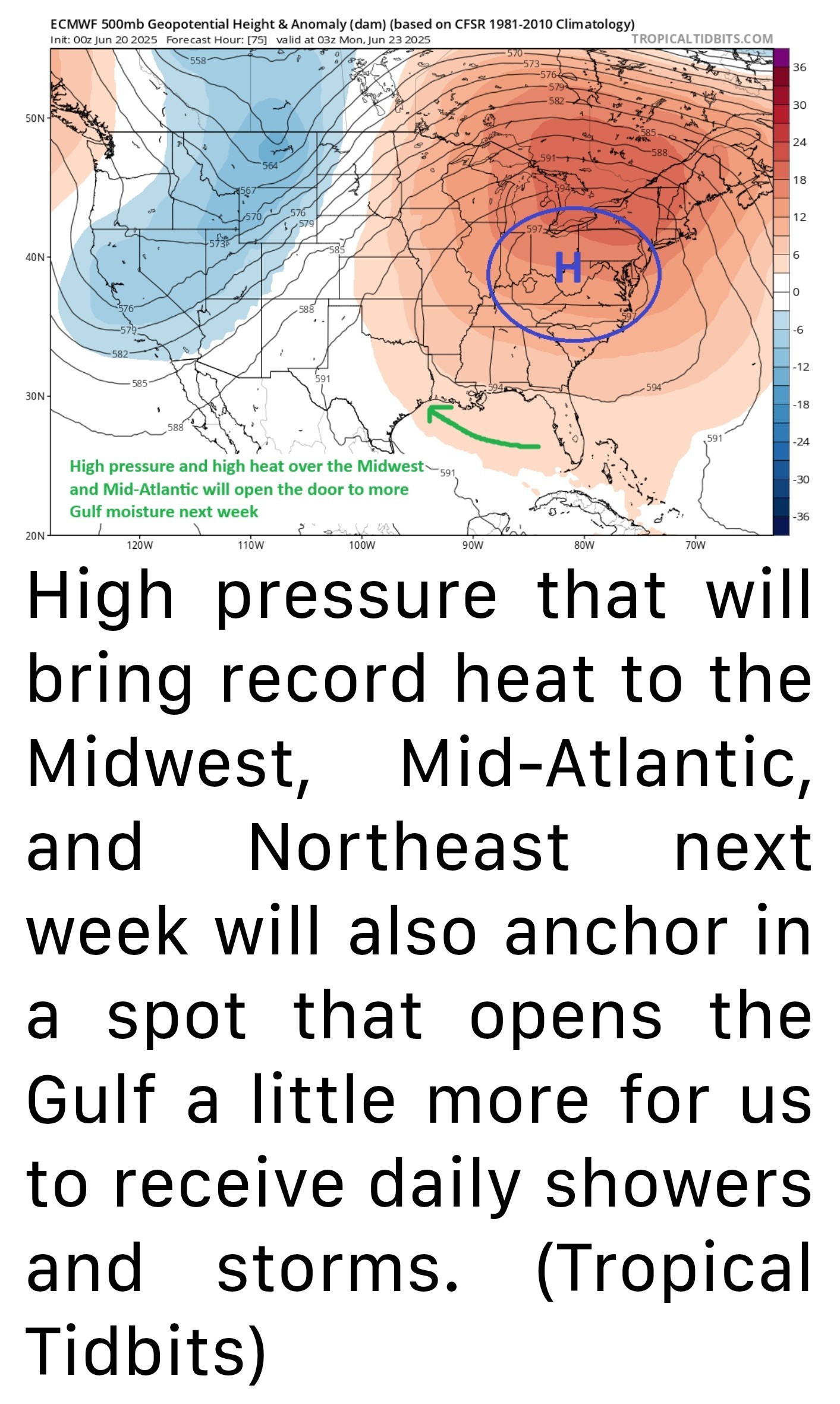 *The culprit will actually be the high pressure system responsible for record heat that I'm sure you'll hear about in the news across the Eastern U.S.
*As that anchors over the Appalachians, it will actually open the door to added Gulf moisture in Texas.
*Precipitable water (or how much moisture is available in the atmosphere) increases about 25 percent or more next week compared to today.
That should help boost thunderstorm coverage each day.
*The increased coverage of storms probably means we see more low-90s for highs and 70s for lows areawide next week. HURRICANE SEASON SO FAR -- 🌀🌀🌀 First, today is June 20th, and to this point I don't think we've said a word at Space City Weather about hurricanes or tropical storms. It's a refreshing change of pace after recent seasons. In fact, the last year that we did not have a storm in the Atlantic before July 1st was back in 2014. It's been a while. 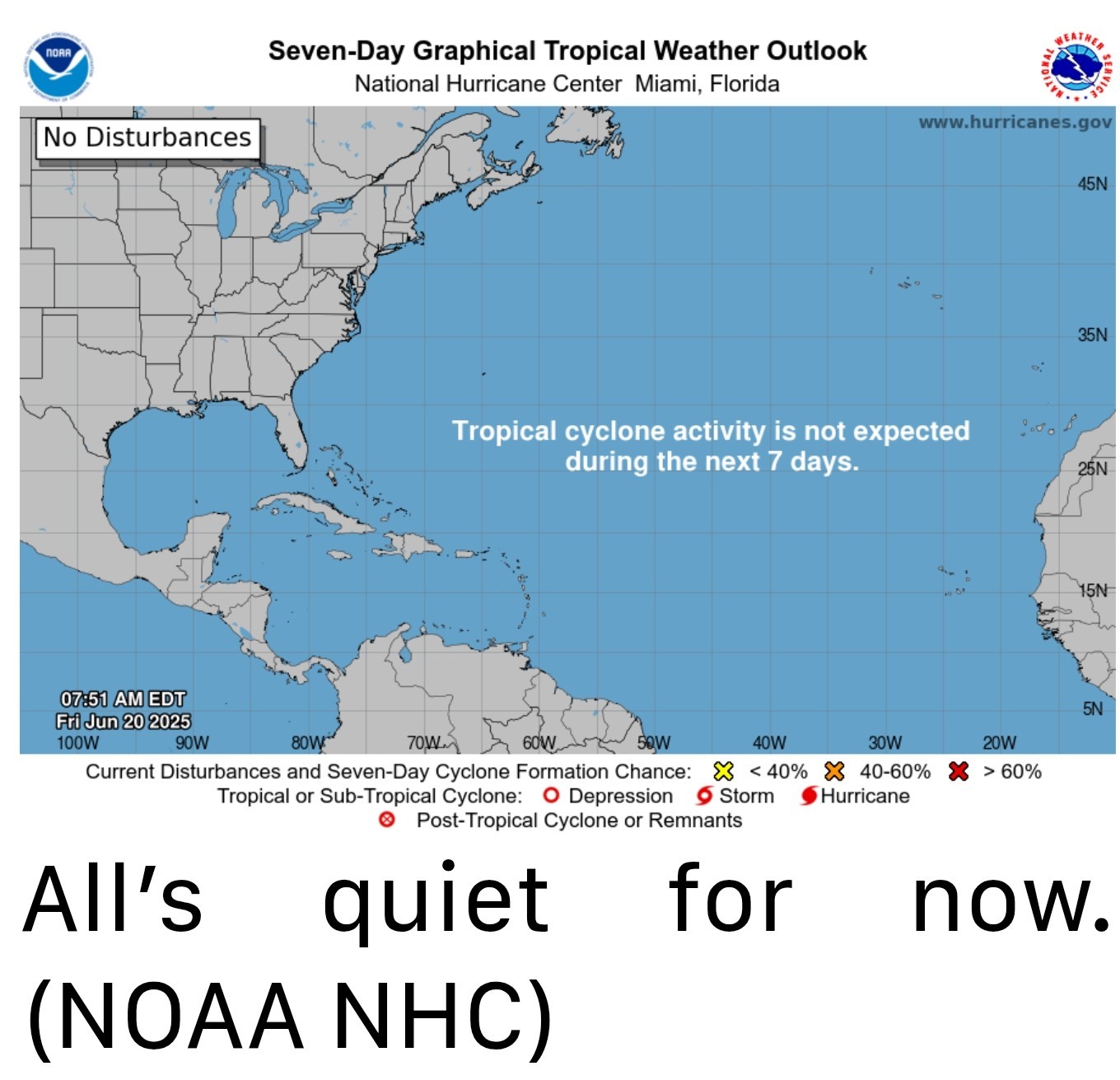 Meanwhile, the Pacific has been churning out storms apace this season, with five so far. Of course, only one of them (Erick, which just made landfall yesterday) was a big storm. Still, the conditions to this point this hurricane season have strongly favored the Pacific. You can thank dust and wind shear in the Atlantic for one, but those things aren't abnormal, even in recent Junes. So there has to be more at play here.
 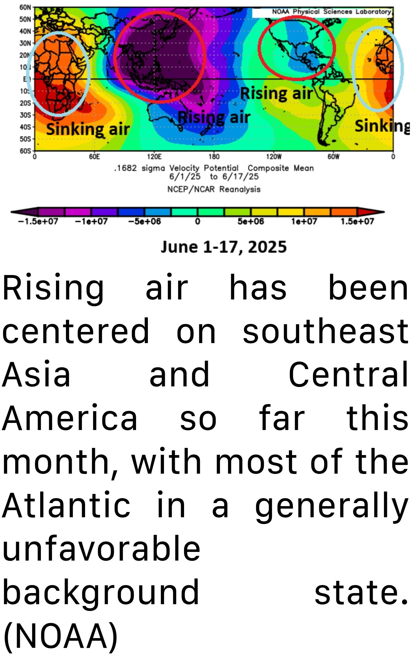 We often talk about the "background state" of the atmosphere. You have individual tropical waves and systems and such through the year, but the background state is important. Are the overarching global weather conditions favorable for development or unfavorable? So far this June, we've had the majority of rising air, or a "favorable" background state for tropical development sitting over Central America. Rising air is what helps thunderstorms to develop. Since tropical weather generally moves east to west across the planet, this has meant that most seedlings for development are being planted in the eastern Pacific Ocean. Sinking air sits over Africa and extends all the way across to the Caribbean islands. Sinking air tends to suppress cloud development and dry the air out a bit. By the time any waves can really get going, they more than likely end up over land or kicked into the Pacific. Over the next couple weeks, this pattern is unlikely to change a whole heck of a lot, but we may start to see slightly more favorable conditions emerge over Africa or the far eastern Atlantic by early July. That said, there are no guarantees that actually means anything. Realistically, the next 7 to 10 days look calm and the 10-to-14-day period has no signs of meaningful change yet. We do still expect an average to above average hurricane season; June's activity has no real correlation to the rest of the season, so you can't decipher any relationships. But when you get a hassle-free month in hurricane season, you take it without complaints. Bottom line: You still have time to prepare for hurricane season. 🌀


*Mostly minimal shower and storm coverage this weekend in Houston will increase by a good bit next week.
*Additionally, we take a look at why this hurricane season has started quieter than most recent ones.
*Most of us will stay dry but some areas could see up to an inch of rain or so in a cooling downpour.
*We hit 95 yesterday officially, and we should make a run for that again today.
*Both Saturday and Sunday carry something like a 15 to 20 percent chance of a shower.
*That doesn't mean it won't rain, but it does mean the odds aren't high!
*Sunday probably carries a slight edge over Saturday in terms of higher shower coverage.
*Temperatures will be steady with low to mid 90s for highs and mid to upper 70s for lows away from the coast, with low 80s at the coast.
*We'll probably carry 30 to 40 percent or even higher rain chances each afternoon, with pop up thunderstorms.
*As that anchors over the Appalachians, it will actually open the door to added Gulf moisture in Texas.
*Precipitable water (or how much moisture is available in the atmosphere) increases about 25 percent or more next week compared to today.
That should help boost thunderstorm coverage each day.
*The increased coverage of storms probably means we see more low-90s for highs and 70s for lows areawide next week.
*********
Replies:

Weekend forecast + hurricane season update Forecast for today, this weekend & next week + an update on hurricane season so far - From Space City Weather - Wetter weather returns to Houston next week, and we take a peek at the quiet hurricane season start so far. Matt Lanza · Friday, June 20, 2025 7:33 AM In brief: *Mostly minimal shower and storm coverage this weekend in Houston will increase by a good bit next week. *Additionally, we take a look at why this hurricane season has started quieter than most recent ones. TODAY -- *We had a slightly higher coverage of showers yesterday than we did Wednesday, and today should be fairly similar. *Most of us will stay dry but some areas could see up to an inch of rain or so in a cooling downpour. *We hit 95 yesterday officially, and we should make a run for that again today. WEEKEND -- *The coverage of showers may actually decrease some this weekend. *Both Saturday and Sunday carry something like a 15 to 20 percent chance of a shower. *That doesn't mean it won't rain, but it does mean the odds aren't high! *Sunday probably carries a slight edge over Saturday in terms of higher shower coverage. *Temperatures will be steady with low to mid 90s for highs and mid to upper 70s for lows away from the coast, with low 80s at the coast. NEXT WEEK -- *While this week was pretty quiet after Monday, next week should be a bit busier each day. *We'll probably carry 30 to 40 percent or even higher rain chances each afternoon, with pop up thunderstorms. *The culprit will actually be the high pressure system responsible for record heat that I'm sure you'll hear about in the news across the Eastern U.S. *As that anchors over the Appalachians, it will actually open the door to added Gulf moisture in Texas. *Precipitable water (or how much moisture is available in the atmosphere) increases about 25 percent or more next week compared to today. That should help boost thunderstorm coverage each day. *The increased coverage of storms probably means we see more low-90s for highs and 70s for lows areawide next week. ************* HURRICANE SEASON SO FAR -- 🌀🌀🌀 First, today is June 20th, and to this point I don't think we've said a word at Space City Weather about hurricanes or tropical storms. It's a refreshing change of pace after recent seasons. In fact, the last year that we did not have a storm in the Atlantic before July 1st was back in 2014. It's been a while. Meanwhile, the Pacific has been churning out storms apace this season, with five so far. Of course, only one of them (Erick, which just made landfall yesterday) was a big storm. Still, the conditions to this point this hurricane season have strongly favored the Pacific. You can thank dust and wind shear in the Atlantic for one, but those things aren't abnormal, even in recent Junes. So there has to be more at play here. We often talk about the "background state" of the atmosphere. You have individual tropical waves and systems and such through the year, but the background state is important. Are the overarching global weather conditions favorable for development or unfavorable? So far this June, we've had the majority of rising air, or a "favorable" background state for tropical development sitting over Central America. Rising air is what helps thunderstorms to develop. Since tropical weather generally moves east to west across the planet, this has meant that most seedlings for development are being planted in the eastern Pacific Ocean. Sinking air sits over Africa and extends all the way across to the Caribbean islands. Sinking air tends to suppress cloud development and dry the air out a bit. By the time any waves can really get going, they more than likely end up over land or kicked into the Pacific. Over the next couple weeks, this pattern is unlikely to change a whole heck of a lot, but we may start to see slightly more favorable conditions emerge over Africa or the far eastern Atlantic by early July. That said, there are no guarantees that actually means anything. Realistically, the next 7 to 10 days look calm and the 10-to-14-day period has no signs of meaningful change yet. We do still expect an average to above average hurricane season; June's activity has no real correlation to the rest of the season, so you can't decipher any relationships. But when you get a hassle-free month in hurricane season, you take it without complaints. Bottom line: You still have time to prepare for hurricane season. 🌀
StormChaser : I need to get busy and pick up a few more things. Thanks. « Back to Chat
Views: 380
# Replies: 3