


This week's forecast
This week's forecast


Joined:
X days ago
# Posts:
X,XXX
Contributor Points:
X


This week's forecast From Space City Weather On and off rain chances remain this week, helping to keep a lid on temperatures Eric Berger · Monday, June 16, 2025 7:10 AM In brief:
*After last week's widespread showers and thunderstorms we expect more rain this week.
*With the potential for flooding diminished, we are dropping our Stage 1 flood alert.
*Daily rain chances should also help keep highs in the vicinity of 90 degrees. A week of rain, more to come -- *The region received a much needed dose of rainfall over the last week, with totals varying from 2 inches (generally in Katy and points west) up to nearly 10 inches (near Baytown).
*Most areas fell somewhere in between with a total of 4 to 6 inches.
*The rains were spread out enough that they did not cause too significant of flooding issues, which is not always easy to pull off in June, when rain can come down in bunches. 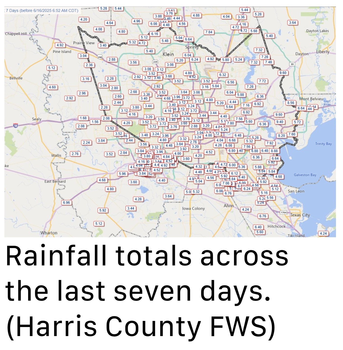 *For the coming week we are going to see a ridge of high pressure attempt to build in from the south, but the Houston region should remain on its periphery.
*Generally, then, we can expect to see daily rain chances but probably not conditions as well organized as last week.
*So keep an umbrella handy, yes, but we are not too concerned about flash flooding. MONDAY -- *Most locations, especially south and east of Highway 59/Interstate 69 will see some rain today. And we cannot rule out some stronger thunderstorms this afternoon which may drop up to about 1 inch.
*Skies will otherwise be partly sunny, with high temperatures in the upper 80s to lower 90s, and fairly light winds from the south.
*Low temperatures tonight will only drop into the upper 70s for most locations. TUESDAY and WEDNESDAY -- *Rain chances are lower during the middle of the week, due to the aforementioned high pressure, perhaps around 30 percent daily.
*I expect both of these days will see high temperatures around 90 degrees, or a tick or two higher, to go along with partly to mostly sunny skies.
*There is a 100 percent chance of mosquitoes after the last week or so of rains. I'm afraid they're going to be bad, y'all. THURSDAY, FRIDAY, SATURDAY, and SUNDAY -- *The end of the week is likely to see a pattern of partly sunny days and high temperatures in the low 90s.
*Highs will depend on whether it rains during the peak heating of the afternoon hours - and I do think it will rain.
*Each day will see around a 50 percent chance of showers and thunderstorms, with "storm-o-clock" coming during the afternoon across the Houston region.
*If you have outdoor plans this weekend, I'm not anticipating a total washout, but you'll want to have a thunderstorm contingency. NEXT WEEK -- At this point it looks like this slightly unsettled pattern will continue into at least the middle of next week, with daily shower chances helping to keep temperatures at a moderate level (for Houston) in late June.


*After last week's widespread showers and thunderstorms we expect more rain this week.
*With the potential for flooding diminished, we are dropping our Stage 1 flood alert.
*Daily rain chances should also help keep highs in the vicinity of 90 degrees.
*Most areas fell somewhere in between with a total of 4 to 6 inches.
*The rains were spread out enough that they did not cause too significant of flooding issues, which is not always easy to pull off in June, when rain can come down in bunches.
*Generally, then, we can expect to see daily rain chances but probably not conditions as well organized as last week.
*So keep an umbrella handy, yes, but we are not too concerned about flash flooding.
*Skies will otherwise be partly sunny, with high temperatures in the upper 80s to lower 90s, and fairly light winds from the south.
*Low temperatures tonight will only drop into the upper 70s for most locations.
*I expect both of these days will see high temperatures around 90 degrees, or a tick or two higher, to go along with partly to mostly sunny skies.
*There is a 100 percent chance of mosquitoes after the last week or so of rains.
*Highs will depend on whether it rains during the peak heating of the afternoon hours - and I do think it will rain.
*Each day will see around a 50 percent chance of showers and thunderstorms, with "storm-o-clock" coming during the afternoon across the Houston region.
*If you have outdoor plans this weekend, I'm not anticipating a total washout, but you'll want to have a thunderstorm contingency.
Replies:
This week's forecast From Space City Weather On and off rain chances remain this week, helping to keep a lid on temperatures Eric Berger · Monday, June 16, 2025 7:10 AM In brief: *After last week's widespread showers and thunderstorms we expect more rain this week. *With the potential for flooding diminished, we are dropping our Stage 1 flood alert. *Daily rain chances should also help keep highs in the vicinity of 90 degrees. A week of rain, more to come -- *The region received a much needed dose of rainfall over the last week, with totals varying from 2 inches (generally in Katy and points west) up to nearly 10 inches (near Baytown). *Most areas fell somewhere in between with a total of 4 to 6 inches. *The rains were spread out enough that they did not cause too significant of flooding issues, which is not always easy to pull off in June, when rain can come down in bunches. *For the coming week we are going to see a ridge of high pressure attempt to build in from the south, but the Houston region should remain on its periphery. *Generally, then, we can expect to see daily rain chances but probably not conditions as well organized as last week. *So keep an umbrella handy, yes, but we are not too concerned about flash flooding. MONDAY -- *Most locations, especially south and east of Highway 59/Interstate 69 will see some rain today. And we cannot rule out some stronger thunderstorms this afternoon which may drop up to about 1 inch. *Skies will otherwise be partly sunny, with high temperatures in the upper 80s to lower 90s, and fairly light winds from the south. *Low temperatures tonight will only drop into the upper 70s for most locations. TUESDAY and WEDNESDAY -- *Rain chances are lower during the middle of the week, due to the aforementioned high pressure, perhaps around 30 percent daily. *I expect both of these days will see high temperatures around 90 degrees, or a tick or two higher, to go along with partly to mostly sunny skies. *There is a 100 percent chance of mosquitoes after the last week or so of rains. I'm afraid they're going to be bad, y'all. THURSDAY, FRIDAY, SATURDAY, and SUNDAY -- *The end of the week is likely to see a pattern of partly sunny days and high temperatures in the low 90s. *Highs will depend on whether it rains during the peak heating of the afternoon hours - and I do think it will rain. *Each day will see around a 50 percent chance of showers and thunderstorms, with "storm-o-clock" coming during the afternoon across the Houston region. *If you have outdoor plans this weekend, I'm not anticipating a total washout, but you'll want to have a thunderstorm contingency. NEXT WEEK -- At this point it looks like this slightly unsettled pattern will continue into at least the middle of next week, with daily shower chances helping to keep temperatures at a moderate level (for Houston) in late June.
StormChaser : I'm curious to see how much this rain has helped with the drought situation throughout central Texas. Last updated map I found was from June 10th and Central Texas was still at level D3 and D4.
StormChaser : I'm curious to see how much this rain has helped with the drought situation throughout central Texas. Last updated map I found was from June 10th and Central Texas was still at level D3 and D4.
olemiss1968 : I have a friend with a house on Lake Canyon and he said there is definitely a difference but they need much more.
olemiss1968 : I have a friend with a house on Lake Canyon and he said there is definitely a difference but they need much more.
StormChaser : That's good to hear.
« Back to Chat
Views: 514
# Replies: 5