


This week's forecast
This week's forecast


Joined:
X days ago
# Posts:
X,XXX
Contributor Points:
X


This week's forecast From Space City Weather: Expect another hot, and mostly sunny week in Houston with a few odds and ends. Eric Berger · Monday, May 19, 2025 6:47 AM In brief: *Houston will see temperatures spike on Tuesday ahead of a weak front that may (very) briefly provide some drier air.
*The rest of the week looks warm and humid, with a chance of rain returning by the weekend. ABOVE AVERAGE TEMPERATURES: *As we have been discussing, Houston has been experiencing a warm spell in the middle of May.
*During the last five days, the average temperature (the daily high and low, divided by two) has been 9 or 10 degrees above normal.
*Our weather has largely been driven by a high pressure system that brought sinking air & mostly sunny skies, but this high pressure system has now shifted away.
*For reasons discussed below, we are still going to be quite warm this week, with one especially hot day (Tuesday) in the forecast. MONDAY: *Highs today should peak in the low 90s, and skies that are at least partly cloudy should help keep a lid on temperatures.
*In addition to high humidity, we will see fairly strong southerly winds, gusting up to 30 mph this afternoon.
*Lows tonight will be muggy, perhaps only briefly dropping below 80 degrees in the city of Houston.
*Coastal locations, of course, will see moderately cooler days and warmer nights. 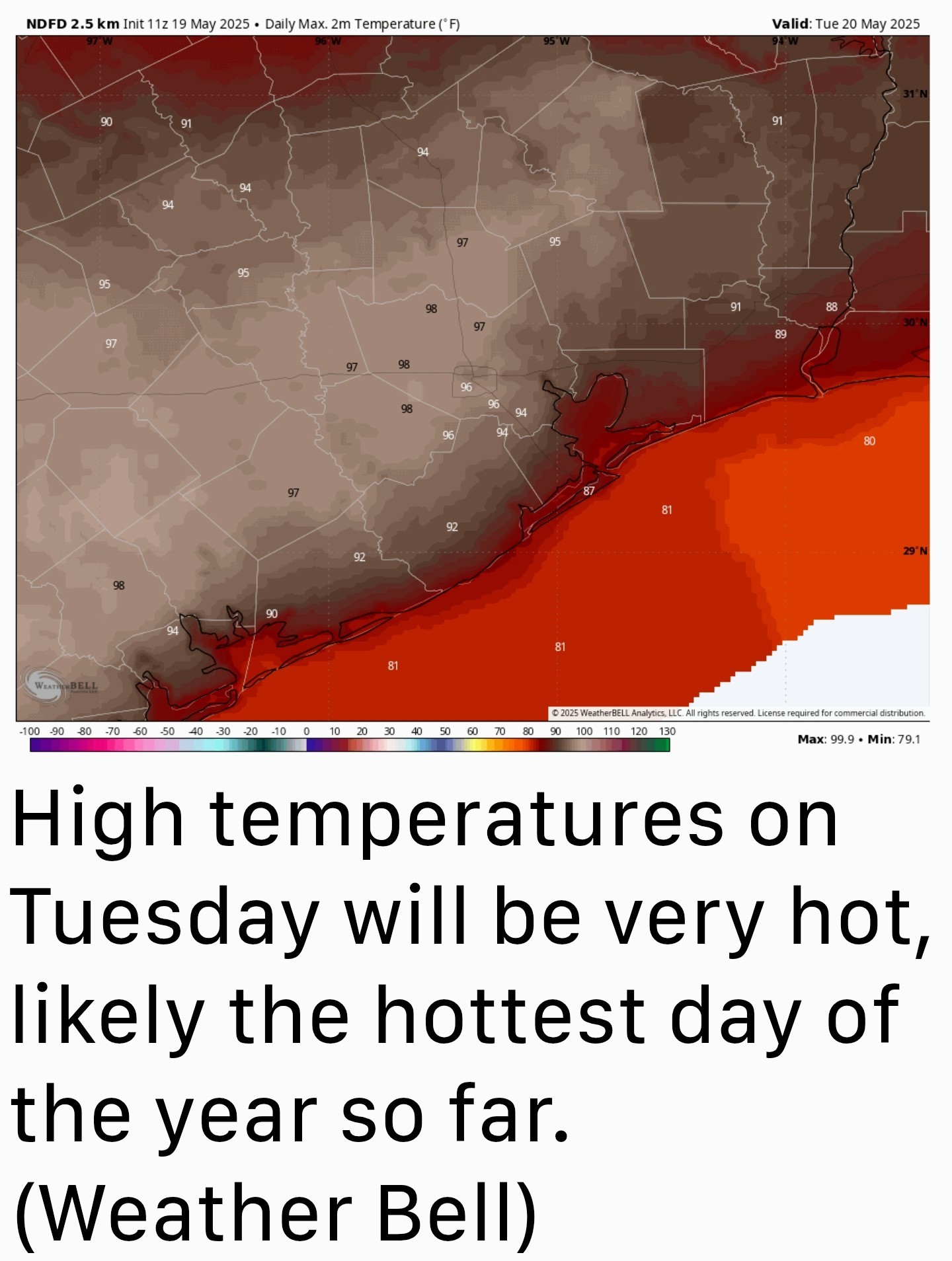 TUESDAY: *A cool front will approach the area on Tuesday, and this will result in compressional heating as winds turn to come from the southwest. (Effectively, the front is compressing and heating air ahead of it as it advances).
*How hot we get on Tuesday will depend on cloud cover during the afternoon, but much of the region has a solid chance to get into the upper 90s.
*One other thing to watch for is the possibility of isolated showers and thunderstorms with the front. I think a capping inversion will be too much for the front to overcome, but it's something we cannot rule out.
*Drier air from this front should eventually move into the area over night, possibly reaching all the way down to the coast.
*Most of the area could see lows in the lower 70s by Wednesday morning. 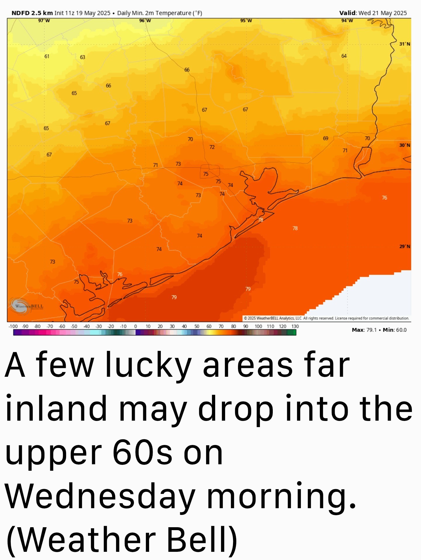 WEDNESDAY: *The front, to the extent it impacts our area, will be briefly lived.
*Said front should have some impact on Wednesday's weather, bringing mostly sunny skies, highs in the lower 90s, and somewhat lower humidity.
*Unfortunately, it will be washed away quickly, with humidity climbing by Wednesday night.
*Expect low temperatures in the mid-70s. THURSDAY AND FRIDAY: *These look to be a pair of mostly sunny, humid days with high temperatures in the low 90s for most, with overnight lows in the mid-70s.
*We should see southerly winds but gusts probably won't get above 15 or 20 mph. SATURDAY AND SUNDAY: *The weekend should see ongoing, mostly sunny weather with high temperatures in the low 90s.
*However, with only modest high pressure in place, I think there is perhaps a 10 percent chance of some showers on Saturday afternoon and 30 percent on Sunday. NEXT WEEK: *The overall pattern for next week looks slightly cooler (highs around 90 degrees, maybe) and wetter.
*We sure could use some rain & the atmospheric setup should support it.
*Still, I'm not going to (confidently) forecast rain 7 to 10 days from now after an extended dry spell. We at least have some hope for rainfall next week.


*The rest of the week looks warm and humid, with a chance of rain returning by the weekend.
*During the last five days, the average temperature (the daily high and low, divided by two) has been 9 or 10 degrees above normal.
*Our weather has largely been driven by a high pressure system that brought sinking air & mostly sunny skies, but this high pressure system has now shifted away.
*For reasons discussed below, we are still going to be quite warm this week, with one especially hot day (Tuesday) in the forecast.
*In addition to high humidity, we will see fairly strong southerly winds, gusting up to 30 mph this afternoon.
*Lows tonight will be muggy, perhaps only briefly dropping below 80 degrees in the city of Houston.
*Coastal locations, of course, will see moderately cooler days and warmer nights.
*How hot we get on Tuesday will depend on cloud cover during the afternoon, but much of the region has a solid chance to get into the upper 90s.
*One other thing to watch for is the possibility of isolated showers and thunderstorms with the front. I think a capping inversion will be too much for the front to overcome, but it's something we cannot rule out.
*Drier air from this front should eventually move into the area over night, possibly reaching all the way down to the coast.
*Most of the area could see lows in the lower 70s by Wednesday morning.
*Said front should have some impact on Wednesday's weather, bringing mostly sunny skies, highs in the lower 90s, and somewhat lower humidity.
*Unfortunately, it will be washed away quickly, with humidity climbing by Wednesday night.
*Expect low temperatures in the mid-70s.
*We should see southerly winds but gusts probably won't get above 15 or 20 mph.
*However, with only modest high pressure in place, I think there is perhaps a 10 percent chance of some showers on Saturday afternoon and 30 percent on Sunday.
*We sure could use some rain & the atmospheric setup should support it.
*Still, I'm not going to (confidently) forecast rain 7 to 10 days from now after an extended dry spell.
Replies:
StormChaser : The summer sizzle is definitely on. The July Fry came early this year. I'm hoping we can get some rain the following week.
 StormChaser: we need some rain the. Lie berries at mooreheads are growing with lack of water ! I need blueberries
we need some rain
rocklady2024 : « Back to Chat
Views: 1,925
# Replies: 4