


Monday weather update - 3pm
Monday weather update - 3pm


Joined:
X days ago
# Posts:
X,XXX
Contributor Points:
X


Monday AM weather update ❗3PM MONDAY UPDATE IN COMMENTS BELOW ❗ From Jeff Lindner
1-20-25 AM ⚠️ Winter Storm Warning for the entire region from 600pm today to 600pm Tuesday.
⚠️ Potentially historic snowstorm for SE TX late today into Tuesday followed by dangerous cold into Wednesday morning.
🚗 Travel will be impossible across the area from late Monday into Wednesday.
❄️ Cold air mass in place this morning under clear skies and light northeast winds.
🌡️ Temperatures have fallen into the low 20's at Huntsville and 28 at Tomball with mid 20's to low 30's over the rest of the area.
⏰ Much advertised winter weather event remains on track starting this evening but even this close to the event there is some uncertainty where the greatest snow accumulations will occur.
-An upper air disturbance over the western US will dig southward and then eastward across Texas tonight and Tuesday.
-Coastal surface trough/low is starting to form along the lower TX coast noted by increasing NE winds along the mid coast this morning.
-A rapidly advancing cloud deck moving northward into the Matagorda Bay region and this overcast/moisture will continue to rapidly expand northward today.
-Low level air mass is extremely dry over the area with current dewpoints in the low 10's to near 20 along the coast.
-A lot of work is to be done to saturate the low levels before precipitation can reach the ground both from bringing moisture into the area and then lifting that moisture.
⏰ Timing: -Expect scattered showers to begin to develop by late afternoon near Matagorda Bay and expand inland into the evening hours.
-Initial precipitation may be all rain before precipitation falling through the air column lowers the temperature profiles to change over to sleet/snow.
-Widespread snow begins to develop later this evening into Tuesday morning when the maximum lift comes to bear across the area.
-High resolution models continue to show strongly banded precipitation on Tuesday morning and it is likely bands of heavy snow will develop over portions of the region.
-Just like with heavy rainfall where the heavier bands become established is questionable, overnight guidance has suggested areas along and south of I-10 may see the higher end type banding.
❄️📏 Accumulations: -Widespread snow amounts of 2-4 inches continue to look likely with lower amounts the further north (1-2 inches) and higher amounts southward (3-5 inches).
-Much of these totals will be determined by the BANDING features and it is possible some areas of the metro area receive 1-2 inches of snow while other areas receive 4-5 inches or higher.
-SREF plumes show the large differences in several of the high resolution guidance members showing totals at Tomball, Hobby, and IAH with possible ranges from near .50 of an inch to nearly 6.0 inches. 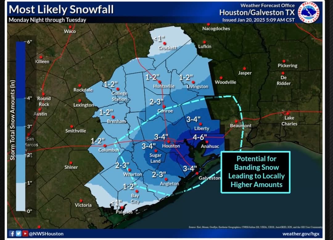 📏 The period from around 400am Tuesday to noon Tuesday will likely feature the most sustained snowfall rates and banding features over the area and when heavy snow is most likely.
🌬️ Gusty winds of 25-30mph along with significantly reduced visibilities in heavy snow will occur late tonight into Tuesday.
🌡️ Cold Temperatures: -After warming into the upper 30's to low 40's today temperatures will fall below freezing this evening and likely remain below freezing until some point Wednesday afternoon.
-It is possible if the snow ends early enough on Tuesday afternoon that some locations could briefly rise above freezing.
-With clearing skies and likely snow on the ground Tuesday night into Wednesday morning will feature very cold conditions over top of the snow pack.
-Areas with significant accumulations of snow will see temperatures fall well into the 10's while areas with lower amounts of snow may "only" fall into the low 20's.
-We will need to take a closer look at Wednesday AM after the snow ends to see if any adjustments need to be made.
-Another night of well below freezing temperatures looks to occur Thursday AM also. 🚗 Area roadways will be slow to recover into late week with likely re-freezing each night into the next morning.
🚗 Travel during these periods will likely be exceptionally dangerous.
🌡️ TUESDAY AM Forecasted Low Temperatures:
*North of HWY 105: 24-26
*North of I-10: 25-28 (US)
*Houston metro (inside Beltway): 27-29
*Coastal Counties: 27-30
*Beaches/Galveston: 30-32 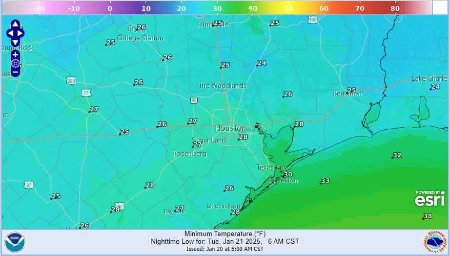 🌡️ WEDNESDAY AM Forecasted Low Temperatures:
*North of HWY 105: 14-17
*North of I-10: 15-18 (US)
*Houston metro (inside Beltway): 17-19
*Coastal Counties: 16-19
*Beaches/Galveston: 27-29 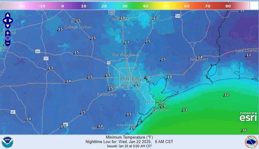 🌡️ THURSDAY AM Forecasted Low Temperatures:
*North of HWY 105: 21-23
*North of I-10: 22-24 (US)
*Houston metro (inside Beltway): 24-26
*Coastal Counties: 24-27
*Beaches/Galveston: 29-34 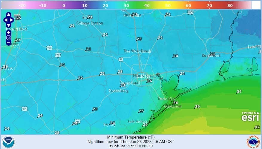 Next update later this afternoon.


1-20-25 AM
⚠️ Potentially historic snowstorm for SE TX late today into Tuesday followed by dangerous cold into Wednesday morning.
🚗 Travel will be impossible across the area from late Monday into Wednesday.
❄️ Cold air mass in place this morning under clear skies and light northeast winds.
🌡️ Temperatures have fallen into the low 20's at Huntsville and 28 at Tomball with mid 20's to low 30's over the rest of the area.
⏰ Much advertised winter weather event remains on track starting this evening but even this close to the event there is some uncertainty where the greatest snow accumulations will occur.
-An upper air disturbance over the western US will dig southward and then eastward across Texas tonight and Tuesday.
-Coastal surface trough/low is starting to form along the lower TX coast noted by increasing NE winds along the mid coast this morning.
-A rapidly advancing cloud deck moving northward into the Matagorda Bay region and this overcast/moisture will continue to rapidly expand northward today.
-Low level air mass is extremely dry over the area with current dewpoints in the low 10's to near 20 along the coast.
-A lot of work is to be done to saturate the low levels before precipitation can reach the ground both from bringing moisture into the area and then lifting that moisture.
⏰ Timing:
-Initial precipitation may be all rain before precipitation falling through the air column lowers the temperature profiles to change over to sleet/snow.
-Widespread snow begins to develop later this evening into Tuesday morning when the maximum lift comes to bear across the area.
-High resolution models continue to show strongly banded precipitation on Tuesday morning and it is likely bands of heavy snow will develop over portions of the region.
-Just like with heavy rainfall where the heavier bands become established is questionable, overnight guidance has suggested areas along and south of I-10 may see the higher end type banding.
❄️📏 Accumulations:
-Much of these totals will be determined by the BANDING features and it is possible some areas of the metro area receive 1-2 inches of snow while other areas receive 4-5 inches or higher.
-SREF plumes show the large differences in several of the high resolution guidance members showing totals at Tomball, Hobby, and IAH with possible ranges from near .50 of an inch to nearly 6.0 inches.
🌬️ Gusty winds of 25-30mph along with significantly reduced visibilities in heavy snow will occur late tonight into Tuesday.
🌡️ Cold Temperatures:
-It is possible if the snow ends early enough on Tuesday afternoon that some locations could briefly rise above freezing.
-With clearing skies and likely snow on the ground Tuesday night into Wednesday morning will feature very cold conditions over top of the snow pack.
-Areas with significant accumulations of snow will see temperatures fall well into the 10's while areas with lower amounts of snow may "only" fall into the low 20's.
-We will need to take a closer look at Wednesday AM after the snow ends to see if any adjustments need to be made.
-Another night of well below freezing temperatures looks to occur Thursday AM also.
🚗 Travel during these periods will likely be exceptionally dangerous.
🌡️ TUESDAY AM Forecasted Low Temperatures:
*North of HWY 105: 24-26
*North of I-10: 25-28 (US)
*Houston metro (inside Beltway): 27-29
*Coastal Counties: 27-30
*Beaches/Galveston: 30-32
*North of HWY 105: 14-17
*North of I-10: 15-18 (US)
*Houston metro (inside Beltway): 17-19
*Coastal Counties: 16-19
*Beaches/Galveston: 27-29
*North of HWY 105: 21-23
*North of I-10: 22-24 (US)
*Houston metro (inside Beltway): 24-26
*Coastal Counties: 24-27
*Beaches/Galveston: 29-34
Discussion Summary:
"Winter Storm Warning: Historic Snowstorm and Dangerous Cold Expected in Southeast Texas"
"Winter Storm Warning: Historic Snowstorm and Dangerous Cold Expected in Southeast Texas"
Discussion Insights:
Ask a question about this discussion and an AI bot will try to give an answer.
Ask a question about this discussion and an AI bot will try to give an answer.
Replies:
StormChaser : it is staying consistent, which is different for Houston weather. Hope you stay warm! Thanks for sharing.

Monday AM weather update From Jeff Lindner
1-20-25 AM ⚠️ Winter Storm Warning for the entire region from 600pm today to 600pm Tuesday.
⚠️ Potentially historic snowstorm for SE TX late today into Tuesday followed by dangerous cold into Wednesday morning.
? Travel will be impossible across the area from late Monday into Wednesday.
❄️ Cold air mass in place this morning under clear skies and light northeast winds.
?️ Temperatures have fallen into the low 20's at Huntsville and 28 at Tomball with mid 20's to low 30's over the rest of the area.
⏰ Much advertised winter weather event remains on track starting this evening but even this close to the event there is some uncertainty where the greatest snow accumulations will occur.
-An upper air disturbance over the western US will dig southward and then eastward across Texas tonight and Tuesday.
-Coastal surface trough/low is starting to form along the lower TX coast noted by increasing NE winds along the mid coast this morning.
-A rapidly advancing cloud deck moving northward into the Matagorda Bay region and this overcast/moisture will continue to rapidly expand northward today.
-Low level air mass is extremely dry over the area with current dewpoints in the low 10's to near 20 along the coast.
-A lot of work is to be done to saturate the low levels before precipitation can reach the ground both from bringing moisture into the area and then lifting that moisture.
⏰ Timing: -Expect scattered showers to begin to develop by late afternoon near Matagorda Bay and expand inland into the evening hours.
-Initial precipitation may be all rain before precipitation falling through the air column lowers the temperature profiles to change over to sleet/snow.
-Widespread snow begins to develop later this evening into Tuesday morning when the maximum lift comes to bear across the area.
-High resolution models continue to show strongly banded precipitation on Tuesday morning and it is likely bands of heavy snow will develop over portions of the region.
-Just like with heavy rainfall where the heavier bands become established is questionable, overnight guidance has suggested areas along and south of I-10 may see the higher end type banding.
❄️? Accumulations: -Widespread snow amounts of 2-4 inches continue to look likely with lower amounts the further north (1-2 inches) and higher amounts southward (3-5 inches).
-Much of these totals will be determined by the BANDING features and it is possible some areas of the metro area receive 1-2 inches of snow while other areas receive 4-5 inches or higher.
-SREF plumes show the large differences in several of the high resolution guidance members showing totals at Tomball, Hobby, and IAH with possible ranges from near .50 of an inch to nearly 6.0 inches. ? The period from around 400am Tuesday to noon Tuesday will likely feature the most sustained snowfall rates and banding features over the area and when heavy snow is most likely.
?️ Gusty winds of 25-30mph along with significantly reduced visibilities in heavy snow will occur late tonight into Tuesday.
?️ Cold Temperatures: -After warming into the upper 30's to low 40's today temperatures will fall below freezing this evening and likely remain below freezing until some point Wednesday afternoon.
-It is possible if the snow ends early enough on Tuesday afternoon that some locations could briefly rise above freezing.
-With clearing skies and likely snow on the ground Tuesday night into Wednesday morning will feature very cold conditions over top of the snow pack.
-Areas with significant accumulations of snow will see temperatures fall well into the 10's while areas with lower amounts of snow may "only" fall into the low 20's.
-We will need to take a closer look at Wednesday AM after the snow ends to see if any adjustments need to be made.
-Another night of well below freezing temperatures looks to occur Thursday AM also. ? Area roadways will be slow to recover into late week with likely re-freezing each night into the next morning.
? Travel during these periods will likely be exceptionally dangerous.
?️ TUESDAY AM Forecasted Low Temperatures:
*North of HWY 105: 24-26
*North of I-10: 25-28 (US)
*Houston metro (inside Beltway): 27-29
*Coastal Counties: 27-30
*Beaches/Galveston: 30-32 ?️ WEDNESDAY AM Forecasted Low Temperatures:
*North of HWY 105: 14-17
*North of I-10: 15-18 (US)
*Houston metro (inside Beltway): 17-19
*Coastal Counties: 16-19
*Beaches/Galveston: 27-29 ?️ THURSDAY AM Forecasted Low Temperatures:
*North of HWY 105: 21-23
*North of I-10: 22-24 (US)
*Houston metro (inside Beltway): 24-26
*Coastal Counties: 24-27
*Beaches/Galveston: 29-34 Next update later this afternoon.
1-20-25 AM
⚠️ Potentially historic snowstorm for SE TX late today into Tuesday followed by dangerous cold into Wednesday morning.
? Travel will be impossible across the area from late Monday into Wednesday.
❄️ Cold air mass in place this morning under clear skies and light northeast winds.
?️ Temperatures have fallen into the low 20's at Huntsville and 28 at Tomball with mid 20's to low 30's over the rest of the area.
⏰ Much advertised winter weather event remains on track starting this evening but even this close to the event there is some uncertainty where the greatest snow accumulations will occur.
-An upper air disturbance over the western US will dig southward and then eastward across Texas tonight and Tuesday.
-Coastal surface trough/low is starting to form along the lower TX coast noted by increasing NE winds along the mid coast this morning.
-A rapidly advancing cloud deck moving northward into the Matagorda Bay region and this overcast/moisture will continue to rapidly expand northward today.
-Low level air mass is extremely dry over the area with current dewpoints in the low 10's to near 20 along the coast.
-A lot of work is to be done to saturate the low levels before precipitation can reach the ground both from bringing moisture into the area and then lifting that moisture.
⏰ Timing:
-Initial precipitation may be all rain before precipitation falling through the air column lowers the temperature profiles to change over to sleet/snow.
-Widespread snow begins to develop later this evening into Tuesday morning when the maximum lift comes to bear across the area.
-High resolution models continue to show strongly banded precipitation on Tuesday morning and it is likely bands of heavy snow will develop over portions of the region.
-Just like with heavy rainfall where the heavier bands become established is questionable, overnight guidance has suggested areas along and south of I-10 may see the higher end type banding.
❄️? Accumulations:
-Much of these totals will be determined by the BANDING features and it is possible some areas of the metro area receive 1-2 inches of snow while other areas receive 4-5 inches or higher.
-SREF plumes show the large differences in several of the high resolution guidance members showing totals at Tomball, Hobby, and IAH with possible ranges from near .50 of an inch to nearly 6.0 inches.
?️ Gusty winds of 25-30mph along with significantly reduced visibilities in heavy snow will occur late tonight into Tuesday.
?️ Cold Temperatures:
-It is possible if the snow ends early enough on Tuesday afternoon that some locations could briefly rise above freezing.
-With clearing skies and likely snow on the ground Tuesday night into Wednesday morning will feature very cold conditions over top of the snow pack.
-Areas with significant accumulations of snow will see temperatures fall well into the 10's while areas with lower amounts of snow may "only" fall into the low 20's.
-We will need to take a closer look at Wednesday AM after the snow ends to see if any adjustments need to be made.
-Another night of well below freezing temperatures looks to occur Thursday AM also.
? Travel during these periods will likely be exceptionally dangerous.
?️ TUESDAY AM Forecasted Low Temperatures:
*North of HWY 105: 24-26
*North of I-10: 25-28 (US)
*Houston metro (inside Beltway): 27-29
*Coastal Counties: 27-30
*Beaches/Galveston: 30-32
*North of HWY 105: 14-17
*North of I-10: 15-18 (US)
*Houston metro (inside Beltway): 17-19
*Coastal Counties: 16-19
*Beaches/Galveston: 27-29
*North of HWY 105: 21-23
*North of I-10: 22-24 (US)
*Houston metro (inside Beltway): 24-26
*Coastal Counties: 24-27
*Beaches/Galveston: 29-34
larpa tipped StormChaser 500 credits for a post in this forum discussion.

|
StormChaser : it is staying consistent, which is different for Houston weather. Hope you stay warm! Thanks for sharing.
Gammyof2 : I'm not leaving my house until Thursday when my kiddo goes back to school! I'm not joking lol. You'll find me buried under layers of blankets, in bed, waiting for summer! 🥶
Monday AM weather update From Jeff Lindner
1-20-25 AM ⚠️ Winter Storm Warning for the entire region from 600pm today to 600pm Tuesday.
⚠️ Potentially historic snowstorm for SE TX late today into Tuesday followed by dangerous cold into Wednesday morning.
? Travel will be impossible across the area from late Monday into Wednesday.
❄️ Cold air mass in place this morning under clear skies and light northeast winds.
?️ Temperatures have fallen into the low 20's at Huntsville and 28 at Tomball with mid 20's to low 30's over the rest of the area.
⏰ Much advertised winter weather event remains on track starting this evening but even this close to the event there is some uncertainty where the greatest snow accumulations will occur.
-An upper air disturbance over the western US will dig southward and then eastward across Texas tonight and Tuesday.
-Coastal surface trough/low is starting to form along the lower TX coast noted by increasing NE winds along the mid coast this morning.
-A rapidly advancing cloud deck moving northward into the Matagorda Bay region and this overcast/moisture will continue to rapidly expand northward today.
-Low level air mass is extremely dry over the area with current dewpoints in the low 10's to near 20 along the coast.
-A lot of work is to be done to saturate the low levels before precipitation can reach the ground both from bringing moisture into the area and then lifting that moisture.
⏰ Timing: -Expect scattered showers to begin to develop by late afternoon near Matagorda Bay and expand inland into the evening hours.
-Initial precipitation may be all rain before precipitation falling through the air column lowers the temperature profiles to change over to sleet/snow.
-Widespread snow begins to develop later this evening into Tuesday morning when the maximum lift comes to bear across the area.
-High resolution models continue to show strongly banded precipitation on Tuesday morning and it is likely bands of heavy snow will develop over portions of the region.
-Just like with heavy rainfall where the heavier bands become established is questionable, overnight guidance has suggested areas along and south of I-10 may see the higher end type banding.
❄️? Accumulations: -Widespread snow amounts of 2-4 inches continue to look likely with lower amounts the further north (1-2 inches) and higher amounts southward (3-5 inches).
-Much of these totals will be determined by the BANDING features and it is possible some areas of the metro area receive 1-2 inches of snow while other areas receive 4-5 inches or higher.
-SREF plumes show the large differences in several of the high resolution guidance members showing totals at Tomball, Hobby, and IAH with possible ranges from near .50 of an inch to nearly 6.0 inches. ? The period from around 400am Tuesday to noon Tuesday will likely feature the most sustained snowfall rates and banding features over the area and when heavy snow is most likely.
?️ Gusty winds of 25-30mph along with significantly reduced visibilities in heavy snow will occur late tonight into Tuesday.
?️ Cold Temperatures: -After warming into the upper 30's to low 40's today temperatures will fall below freezing this evening and likely remain below freezing until some point Wednesday afternoon.
-It is possible if the snow ends early enough on Tuesday afternoon that some locations could briefly rise above freezing.
-With clearing skies and likely snow on the ground Tuesday night into Wednesday morning will feature very cold conditions over top of the snow pack.
-Areas with significant accumulations of snow will see temperatures fall well into the 10's while areas with lower amounts of snow may "only" fall into the low 20's.
-We will need to take a closer look at Wednesday AM after the snow ends to see if any adjustments need to be made.
-Another night of well below freezing temperatures looks to occur Thursday AM also. ? Area roadways will be slow to recover into late week with likely re-freezing each night into the next morning.
? Travel during these periods will likely be exceptionally dangerous.
?️ TUESDAY AM Forecasted Low Temperatures:
*North of HWY 105: 24-26
*North of I-10: 25-28 (US)
*Houston metro (inside Beltway): 27-29
*Coastal Counties: 27-30
*Beaches/Galveston: 30-32 ?️ WEDNESDAY AM Forecasted Low Temperatures:
*North of HWY 105: 14-17
*North of I-10: 15-18 (US)
*Houston metro (inside Beltway): 17-19
*Coastal Counties: 16-19
*Beaches/Galveston: 27-29 ?️ THURSDAY AM Forecasted Low Temperatures:
*North of HWY 105: 21-23
*North of I-10: 22-24 (US)
*Houston metro (inside Beltway): 24-26
*Coastal Counties: 24-27
*Beaches/Galveston: 29-34 Next update later this afternoon.
1-20-25 AM
⚠️ Potentially historic snowstorm for SE TX late today into Tuesday followed by dangerous cold into Wednesday morning.
? Travel will be impossible across the area from late Monday into Wednesday.
❄️ Cold air mass in place this morning under clear skies and light northeast winds.
?️ Temperatures have fallen into the low 20's at Huntsville and 28 at Tomball with mid 20's to low 30's over the rest of the area.
⏰ Much advertised winter weather event remains on track starting this evening but even this close to the event there is some uncertainty where the greatest snow accumulations will occur.
-An upper air disturbance over the western US will dig southward and then eastward across Texas tonight and Tuesday.
-Coastal surface trough/low is starting to form along the lower TX coast noted by increasing NE winds along the mid coast this morning.
-A rapidly advancing cloud deck moving northward into the Matagorda Bay region and this overcast/moisture will continue to rapidly expand northward today.
-Low level air mass is extremely dry over the area with current dewpoints in the low 10's to near 20 along the coast.
-A lot of work is to be done to saturate the low levels before precipitation can reach the ground both from bringing moisture into the area and then lifting that moisture.
⏰ Timing:
-Initial precipitation may be all rain before precipitation falling through the air column lowers the temperature profiles to change over to sleet/snow.
-Widespread snow begins to develop later this evening into Tuesday morning when the maximum lift comes to bear across the area.
-High resolution models continue to show strongly banded precipitation on Tuesday morning and it is likely bands of heavy snow will develop over portions of the region.
-Just like with heavy rainfall where the heavier bands become established is questionable, overnight guidance has suggested areas along and south of I-10 may see the higher end type banding.
❄️? Accumulations:
-Much of these totals will be determined by the BANDING features and it is possible some areas of the metro area receive 1-2 inches of snow while other areas receive 4-5 inches or higher.
-SREF plumes show the large differences in several of the high resolution guidance members showing totals at Tomball, Hobby, and IAH with possible ranges from near .50 of an inch to nearly 6.0 inches.
?️ Gusty winds of 25-30mph along with significantly reduced visibilities in heavy snow will occur late tonight into Tuesday.
?️ Cold Temperatures:
-It is possible if the snow ends early enough on Tuesday afternoon that some locations could briefly rise above freezing.
-With clearing skies and likely snow on the ground Tuesday night into Wednesday morning will feature very cold conditions over top of the snow pack.
-Areas with significant accumulations of snow will see temperatures fall well into the 10's while areas with lower amounts of snow may "only" fall into the low 20's.
-We will need to take a closer look at Wednesday AM after the snow ends to see if any adjustments need to be made.
-Another night of well below freezing temperatures looks to occur Thursday AM also.
? Travel during these periods will likely be exceptionally dangerous.
?️ TUESDAY AM Forecasted Low Temperatures:
*North of HWY 105: 24-26
*North of I-10: 25-28 (US)
*Houston metro (inside Beltway): 27-29
*Coastal Counties: 27-30
*Beaches/Galveston: 30-32
*North of HWY 105: 14-17
*North of I-10: 15-18 (US)
*Houston metro (inside Beltway): 17-19
*Coastal Counties: 16-19
*Beaches/Galveston: 27-29
*North of HWY 105: 21-23
*North of I-10: 22-24 (US)
*Houston metro (inside Beltway): 24-26
*Coastal Counties: 24-27
*Beaches/Galveston: 29-34
 Annie tipped StormChaser 500 credits for a post in this forum discussion.
|
|
Monday AM weather update From Jeff Lindner 1-20-25 AM ⚠️ Winter Storm Warning for the entire region from 600pm today to 600pm Tuesday. ⚠️ Potentially historic snowstorm for SE TX late today into Tuesday followed by dangerous cold into Wednesday morning. 🚗 Travel will be impossible across the area from late Monday into Wednesday. ❄️ Cold air mass in place this morning under clear skies and light northeast winds. 🌡️ Temperatures have fallen into the low 20's at Huntsville and 28 at Tomball with mid 20's to low 30's over the rest of the area. ⏰ Much advertised winter weather event remains on track starting this evening but even this close to the event there is some uncertainty where the greatest snow accumulations will occur. -An upper air disturbance over the western US will dig southward and then eastward across Texas tonight and Tuesday. -Coastal surface trough/low is starting to form along the lower TX coast noted by increasing NE winds along the mid coast this morning. -A rapidly advancing cloud deck moving northward into the Matagorda Bay region and this overcast/moisture will continue to rapidly expand northward today. -Low level air mass is extremely dry over the area with current dewpoints in the low 10's to near 20 along the coast. -A lot of work is to be done to saturate the low levels before precipitation can reach the ground both from bringing moisture into the area and then lifting that moisture. ⏰ Timing: -Expect scattered showers to begin to develop by late afternoon near Matagorda Bay and expand inland into the evening hours. -Initial precipitation may be all rain before precipitation falling through the air column lowers the temperature profiles to change over to sleet/snow. -Widespread snow begins to develop later this evening into Tuesday morning when the maximum lift comes to bear across the area. -High resolution models continue to show strongly banded precipitation on Tuesday morning and it is likely bands of heavy snow will develop over portions of the region. -Just like with heavy rainfall where the heavier bands become established is questionable, overnight guidance has suggested areas along and south of I-10 may see the higher end type banding. ❄️📏 Accumulations: -Widespread snow amounts of 2-4 inches continue to look likely with lower amounts the further north (1-2 inches) and higher amounts southward (3-5 inches). -Much of these totals will be determined by the BANDING features and it is possible some areas of the metro area receive 1-2 inches of snow while other areas receive 4-5 inches or higher. -SREF plumes show the large differences in several of the high resolution guidance members showing totals at Tomball, Hobby, and IAH with possible ranges from near .50 of an inch to nearly 6.0 inches. 📏 The period from around 400am Tuesday to noon Tuesday will likely feature the most sustained snowfall rates and banding features over the area and when heavy snow is most likely. 🌬️ Gusty winds of 25-30mph along with significantly reduced visibilities in heavy snow will occur late tonight into Tuesday. 🌡️ Cold Temperatures: -After warming into the upper 30's to low 40's today temperatures will fall below freezing this evening and likely remain below freezing until some point Wednesday afternoon. -It is possible if the snow ends early enough on Tuesday afternoon that some locations could briefly rise above freezing. -With clearing skies and likely snow on the ground Tuesday night into Wednesday morning will feature very cold conditions over top of the snow pack. -Areas with significant accumulations of snow will see temperatures fall well into the 10's while areas with lower amounts of snow may "only" fall into the low 20's. -We will need to take a closer look at Wednesday AM after the snow ends to see if any adjustments need to be made. -Another night of well below freezing temperatures looks to occur Thursday AM also. 🚗 Area roadways will be slow to recover into late week with likely re-freezing each night into the next morning. 🚗 Travel during these periods will likely be exceptionally dangerous. 🌡️ TUESDAY AM Forecasted Low Temperatures: *North of HWY 105: 24-26 *North of I-10: 25-28 (US) *Houston metro (inside Beltway): 27-29 *Coastal Counties: 27-30 *Beaches/Galveston: 30-32 🌡️ WEDNESDAY AM Forecasted Low Temperatures: *North of HWY 105: 14-17 *North of I-10: 15-18 (US) *Houston metro (inside Beltway): 17-19 *Coastal Counties: 16-19 *Beaches/Galveston: 27-29 🌡️ THURSDAY AM Forecasted Low Temperatures: *North of HWY 105: 21-23 *North of I-10: 22-24 (US) *Houston metro (inside Beltway): 24-26 *Coastal Counties: 24-27 *Beaches/Galveston: 29-34 Next update later this afternoon.
 StormChaser : Noooooo!
|
|
Light precipitation will expand northward through the day….very dry surface layer will take time to saturate with current dewpoints in the 10's Clouds have come in a bit faster than expected and this will likely limit much warming today…doubt we reach the 40's. Increasing NE winds will keep very cold wind chills in place in the 10's and low 20's. 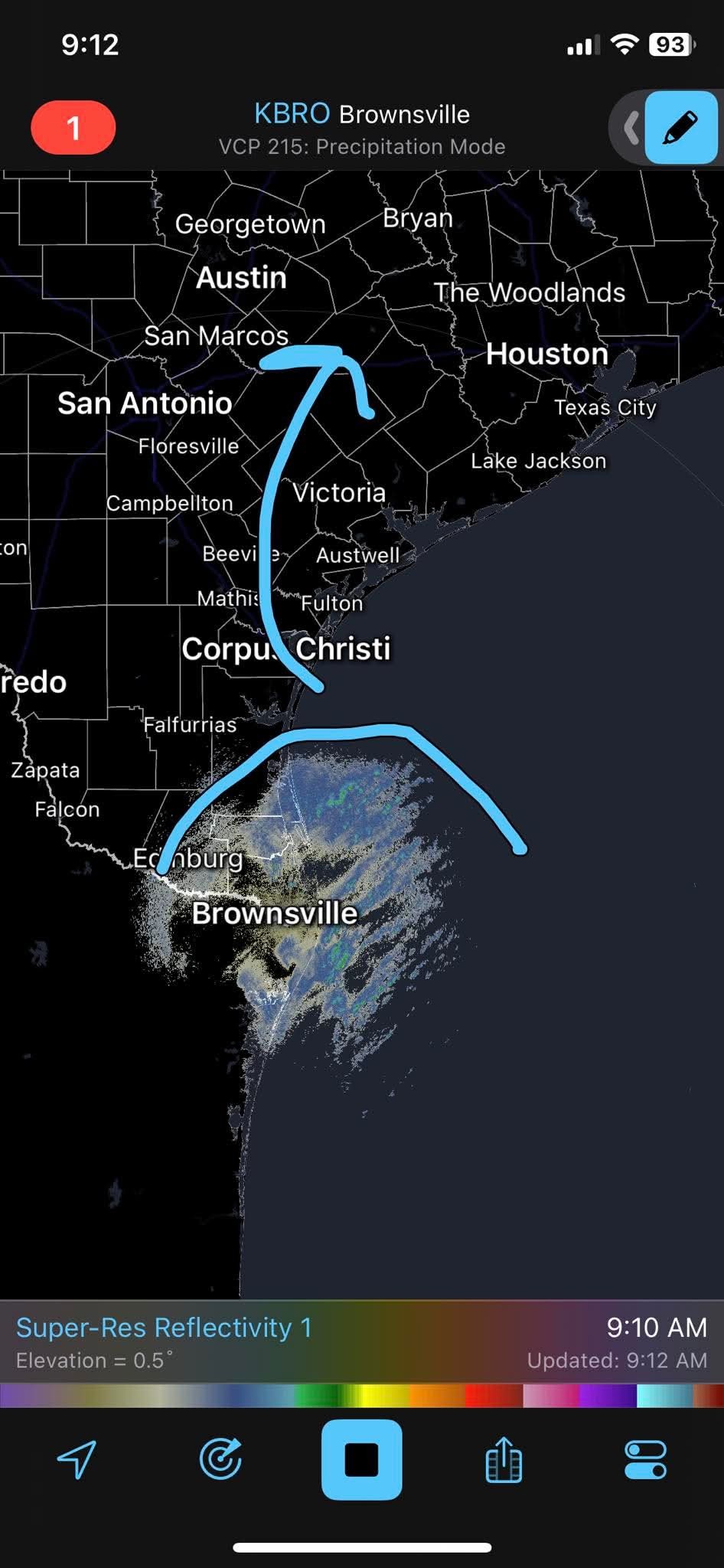
|
|
Gammyof2 : I'm not leaving my house until Thursday when my kiddo goes back to school! I'm not joking lol. You'll find me buried under layers of blankets, in bed, waiting for summer! 🥶
StormChaser :
|
|
1-20-25 300pm UPDATE This is nuts. I'm waiting for APRIL FOOLS. 😂 Winter storm likey tonight into tomorrow midday. ❄️ Accumulations of snow likely over the area. ❄️ Graphics below should the probability of greater than 4 inches and greater than 6 inches of snow over the area. ❄️ Last graphic is showing the current forecast snowfall.
❄️ We could see some locally higher totals south of I-10 where the most sustained banding will be found. ❄️ Precipitation begin after 9:00pm this evening and with end around midday Tuesday with the heaviest snow between 3:00am and 10:00am Tuesday (tomorrow) morning. 🚗✈️ Travel will be nearly impossible on Tuesday. 🚗 TXDOT has 22 plows in place to work interstates and US corridors. 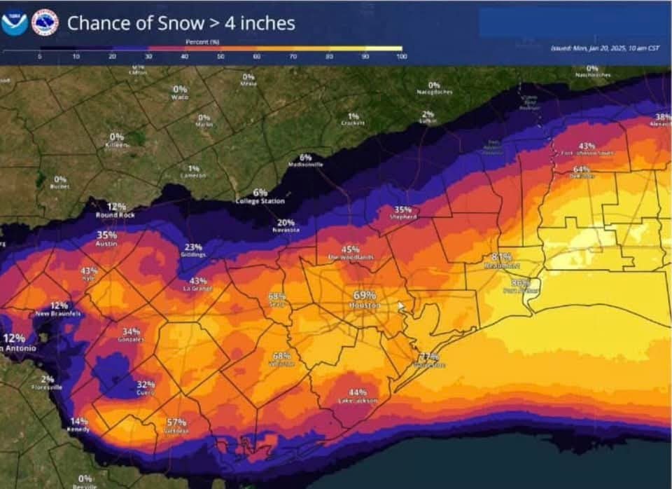
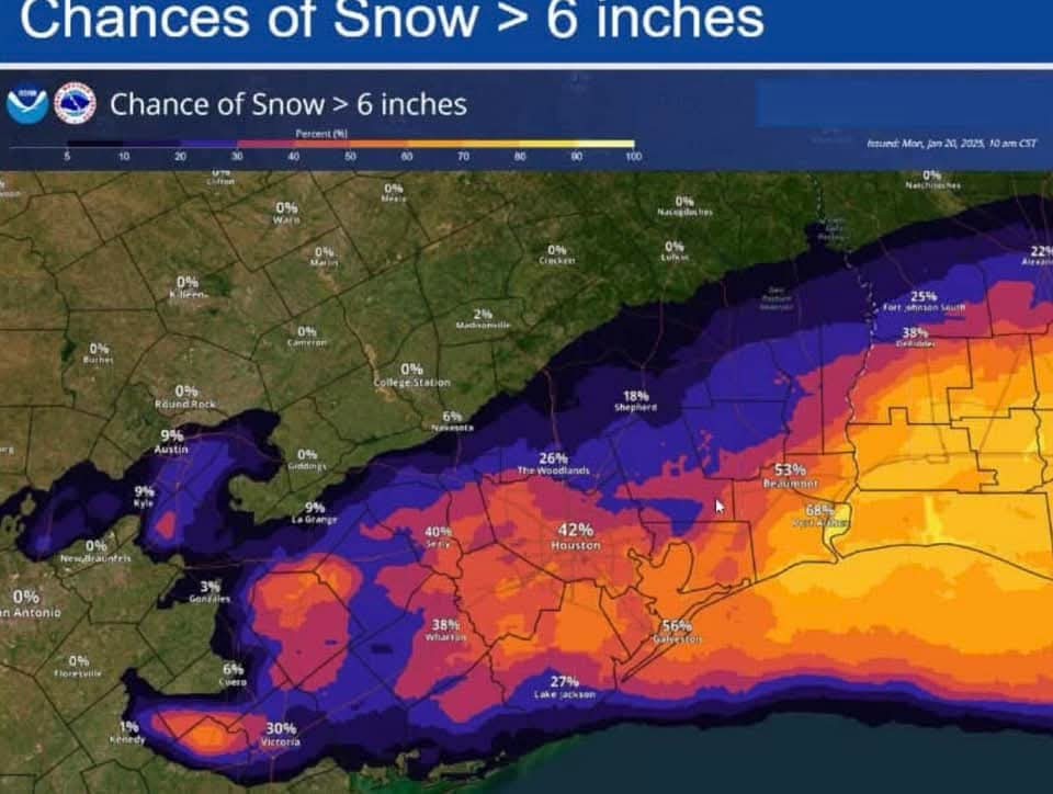
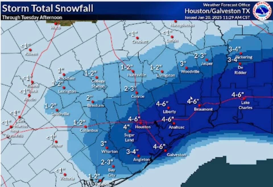
❄️ We could see some locally higher totals south of I-10 where the most sustained banding will be found.
Gammyof2 : I'm not leaving my house until Thursday when my kiddo goes back to school! I'm not joking lol. You'll find me buried under layers of blankets, in bed, waiting for summer! 🥶
StormChaser : Weenie 🤣 « Back to Chat
Views: 1,149
# Replies: 12