


Heavy rainfall in the 7 day forecast
Heavy rainfall in the 7 day forecast

This discussion has been locked.

Joined:
X days ago
# Posts:
X,XXX
Contributor Points:
X


Heavy rainfall in the 7 day forecast Houston Is Set For A Very Rainy Stretch Of Weather Heading Through Next Week. Sigh. Y'all, I really hopefully this doesn't cause any electricity issues - especially since I've only had it back for 24 hours yet & others are still out. -Isolated showers today and tomorrow.
-Heavy Rainfall chances increase on Sunday.
-As of right now, timing is still not nailed down but MON/TUES and again on WED/THURS are our best chances to pick up an additional 3-6" of rain on top of the rainfall totals through the weekend.
-Issues will include numerous daily rain chances, locally heavy rain & a few strong storms.
-Temps will stay in the 80s for the most part due to the storms & cloud cover. ........ From Space City Weather: In brief:Â *A smattering of showers and thunderstorms will be with us today and tomorrow.
*More scattered storms are in play for Sunday
*Widespread rain and thunderstorms will be the forecast for much of next week with - locally heavy rain, some flooding, gusty winds at times, but also cooler temperatures. TODAY: We have two clusters of storms this morning in the area. *The first is to the west of Sugar Land, dropping across Wharton County.
*A second area of storms extends from Kingwood east toward Beaumont.
*Those should continue to drop southward and gradually weaken.
*Look for a few more showers and storms to form this afternoon. Moving south: 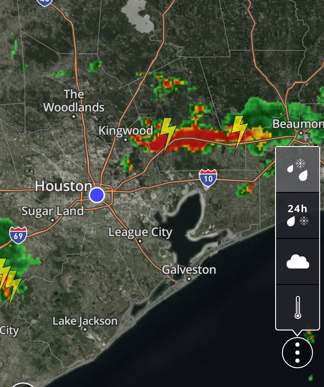 *After failing to hit 90 yesterday (thanks to cloud cover and rain-cooled air behind yesterday morning's system) highs will top off in the low-90s today. THE WEEKEND: -SATURDAY - Saturday actually looks like a fairly decent day overall. *Yes, there will be a chance of showers or a thunderstorm, but as a whole, rain chances will be at a relative low compared to what's ahead Sunday and beyond.
*Look for a smattering of afternoon showers and highs in the low-90s. -SUNDAY - SUNDAY looks a little busier. *We'll have a little more moisture and enough support for more in the way of scattered thunderstorms.
*Lows will be in the 70s, with highs around 90 or a little hotter depending on rainfall. MONDAY THROUGH THURSDAY: *If you have plans next week that involve anything outdoors, make sure you also have an alternative lined up.
*It looks like a chaotic, busy week in the atmosphere over Texas.
*We will have numerous vigorous disturbances pushing across Texas with a large trough in the upper atmosphere.
*This means numerous daily rain chances, locally heavy rain, a few strong storms, and cooler temperatures than normal. 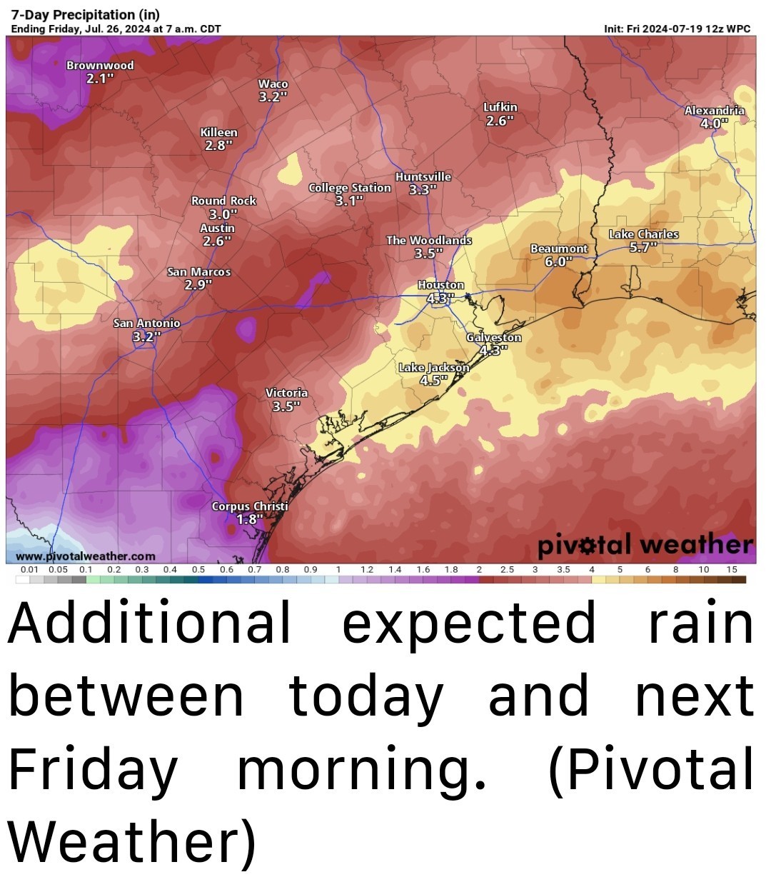 *It remains very difficult to predict exactly when the heaviest rain will be.
*Right now I'd hone in on later MONDAY or TUESDAY and again later WEDNESDAY or THURSDAY for the best odds but that may shift around a bit.
*What we do know is that the amount of moisture available in the atmosphere will be 100 to 150 percent of normal, which typically translates to at least a couple rounds of heavy rainfall.
*The Weather Prediction Center currently has forecasts for excessive rain out through Tuesday and has the region at least in a marginal risk (level 1 of 4) each day.
*I would say to expect an ADDITIONAL 3 to 6 inches on AVERAGE across the region.
*Some places may see a bit less than that, but it's conceivable that a couple places will see MORE with enough storm activity through next Thursday.
*We will likely have to dust off the flood scale again Sunday or Monday and keep it up through Thursday or Friday.
*This would be primarily for street flooding concerns. Check back with us for more perhaps on Sunday. *While thunderstorms are likely, severe weather is possible, but not likely.
*Any severe storms should be isolated and brief.
*There will be gusty winds at times with any storms, and severe or not, that may be both unsettling to you and the power system.
*Periodic temporary power outages can't be ruled out through next week - I get the anxiety, trust me. 😢 *As noted, cooler weather will arrive next week thanks to the clouds and rain. 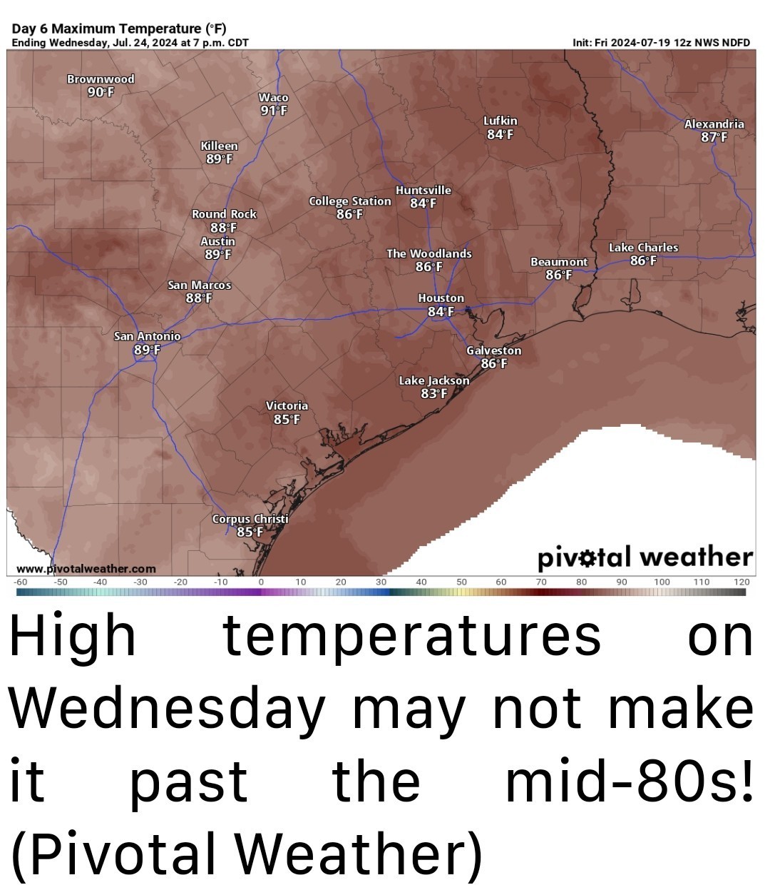 *For example, on Wednesday, like some people's taste in music 🤣 we will struggle to get past the mid-80s.
*These suppressed daytime highs will continue into late week before we slowly rebound next weekend.
*Nighttime lows will not necessarily play along, as they should remain in the 70s. ....... A quick housekeeping note: The latest version of the Space City Weather app is available for Android and iOS now. Dwight will have a post out later this morning explaining the changes that went into this version and how you can report any bugs (not just the mosquitoes landing on your phone inside your house). As a side note, since beginning this journey with Eric almost 10 years ago now, it's pretty cool to see how far this has come. No app is perfect, but I am proud of ours, and I hope you find it to be useful.


-Heavy Rainfall chances increase on Sunday.
-As of right now, timing is still not nailed down but MON/TUES and again on WED/THURS are our best chances to pick up an additional 3-6" of rain on top of the rainfall totals through the weekend.
-Issues will include numerous daily rain chances, locally heavy rain & a few strong storms.
-Temps will stay in the 80s for the most part due to the storms & cloud cover.
*More scattered storms are in play for Sunday
*Widespread rain and thunderstorms will be the forecast for much of next week with - locally heavy rain, some flooding, gusty winds at times, but also cooler temperatures.
*A second area of storms extends from Kingwood east toward Beaumont.
*Those should continue to drop southward and gradually weaken.
*Look for a few more showers and storms to form this afternoon.
*Look for a smattering of afternoon showers and highs in the low-90s.
*Lows will be in the 70s, with highs around 90 or a little hotter depending on rainfall.
*It looks like a chaotic, busy week in the atmosphere over Texas.
*We will have numerous vigorous disturbances pushing across Texas with a large trough in the upper atmosphere.
*This means numerous daily rain chances, locally heavy rain, a few strong storms, and cooler temperatures than normal.
*Right now I'd hone in on later MONDAY or TUESDAY and again later WEDNESDAY or THURSDAY for the best odds but that may shift around a bit.
*What we do know is that the amount of moisture available in the atmosphere will be 100 to 150 percent of normal, which typically translates to at least a couple rounds of heavy rainfall.
*The Weather Prediction Center currently has forecasts for excessive rain out through Tuesday and has the region at least in a marginal risk (level 1 of 4) each day.
*I would say to expect an ADDITIONAL 3 to 6 inches on AVERAGE across the region.
*Some places may see a bit less than that, but it's conceivable that a couple places will see MORE with enough storm activity through next Thursday.
*We will likely have to dust off the flood scale again Sunday or Monday and keep it up through Thursday or Friday.
*This would be primarily for street flooding concerns.
*Any severe storms should be isolated and brief.
*There will be gusty winds at times with any storms, and severe or not, that may be both unsettling to you and the power system.
*Periodic temporary power outages can't be ruled out through next week - I get the anxiety, trust me. 😢
*These suppressed daytime highs will continue into late week before we slowly rebound next weekend.
*Nighttime lows will not necessarily play along, as they should remain in the 70s.
Discussion Summary:
Houston Forecast: Heavy Rain and Storms Expected Next Week, Potential for Flooding and Power Outages
Houston Forecast: Heavy Rain and Storms Expected Next Week, Potential for Flooding and Power Outages
Discussion Insights:
Ask a question about this discussion and an AI bot will try to give an answer.
Ask a question about this discussion and an AI bot will try to give an answer.
Replies:
StormChaser : thank you for your update, I appreciate it. The cooler temperatures have been a pleasant surprise. I, like you, pray for those still without power and those with roof damage. Enjoy your day!

|
StormChaser : thank you for your update, I appreciate it. The cooler temperatures have been a pleasant surprise. I, like you, pray for those still without power and those with roof damage. Enjoy your day!
Gammyof2 : Yeah the winds are a concern. It wouldn't normally make think twice, but with all these massive limbs hanging everywhere, it's nerve racking.....to say the least.


Heavy rainfall in the 7 day forecast Houston Is Set For A Very Rainy Stretch Of Weather Heading Through Next Week. Sigh. Y'all, I really hopefully this doesn't cause any electricity issues - especially since I've only had it back for 24 hours yet & others are still out. -Isolated showers today and tomorrow. -Heavy Rainfall chances increase on Sunday. -As of right now, timing is still not nailed down but MON/TUES and again on WED/THURS are our best chances to pick up an additional 3-6" of rain on top of the rainfall totals through the weekend. -Issues will include numerous daily rain chances, locally heavy rain & a few strong storms. -Temps will stay in the 80s for the most part due to the storms & cloud cover. ........ From Space City Weather: In brief: *A smattering of showers and thunderstorms will be with us today and tomorrow. *More scattered storms are in play for Sunday *Widespread rain and thunderstorms will be the forecast for much of next week with - locally heavy rain, some flooding, gusty winds at times, but also cooler temperatures. TODAY: We have two clusters of storms this morning in the area. *The first is to the west of Sugar Land, dropping across Wharton County. *A second area of storms extends from Kingwood east toward Beaumont. *Those should continue to drop southward and gradually weaken. *Look for a few more showers and storms to form this afternoon. Moving south: *After failing to hit 90 yesterday (thanks to cloud cover and rain-cooled air behind yesterday morning's system) highs will top off in the low-90s today. THE WEEKEND: -SATURDAY - Saturday actually looks like a fairly decent day overall. *Yes, there will be a chance of showers or a thunderstorm, but as a whole, rain chances will be at a relative low compared to what's ahead Sunday and beyond. *Look for a smattering of afternoon showers and highs in the low-90s. -SUNDAY - SUNDAY looks a little busier. *We'll have a little more moisture and enough support for more in the way of scattered thunderstorms. *Lows will be in the 70s, with highs around 90 or a little hotter depending on rainfall. MONDAY THROUGH THURSDAY: *If you have plans next week that involve anything outdoors, make sure you also have an alternative lined up. *It looks like a chaotic, busy week in the atmosphere over Texas. *We will have numerous vigorous disturbances pushing across Texas with a large trough in the upper atmosphere. *This means numerous daily rain chances, locally heavy rain, a few strong storms, and cooler temperatures than normal. *It remains very difficult to predict exactly when the heaviest rain will be. *Right now I'd hone in on later MONDAY or TUESDAY and again later WEDNESDAY or THURSDAY for the best odds but that may shift around a bit. *What we do know is that the amount of moisture available in the atmosphere will be 100 to 150 percent of normal, which typically translates to at least a couple rounds of heavy rainfall. *The Weather Prediction Center currently has forecasts for excessive rain out through Tuesday and has the region at least in a marginal risk (level 1 of 4) each day. *I would say to expect an ADDITIONAL 3 to 6 inches on AVERAGE across the region. *Some places may see a bit less than that, but it's conceivable that a couple places will see MORE with enough storm activity through next Thursday. *We will likely have to dust off the flood scale again Sunday or Monday and keep it up through Thursday or Friday. *This would be primarily for street flooding concerns. Check back with us for more perhaps on Sunday. *While thunderstorms are likely, severe weather is possible, but not likely. *Any severe storms should be isolated and brief. *There will be gusty winds at times with any storms, and severe or not, that may be both unsettling to you and the power system. *Periodic temporary power outages can't be ruled out through next week - I get the anxiety, trust me. 😢 *As noted, cooler weather will arrive next week thanks to the clouds and rain. *For example, on Wednesday, like some people's taste in music 🤣 we will struggle to get past the mid-80s. *These suppressed daytime highs will continue into late week before we slowly rebound next weekend. *Nighttime lows will not necessarily play along, as they should remain in the 70s. ....... A quick housekeeping note: The latest version of the Space City Weather app is available for Android and iOS now. Dwight will have a post out later this morning explaining the changes that went into this version and how you can report any bugs (not just the mosquitoes landing on your phone inside your house). As a side note, since beginning this journey with Eric almost 10 years ago now, it's pretty cool to see how far this has come. No app is perfect, but I am proud of ours, and I hope you find it to be useful.
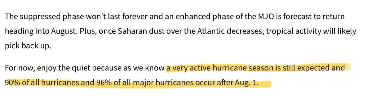 StormChaser : Excerpt from NOAA article. I mention to remind, encourage folks to prepare for what's to come. Not that Beryl hasn't been the perfect reminder, and truly this lull couldn't come at a more needed time - the reawakening cometh.
Last year at this time we were all praying for rain. That heat dome that sat on us was so brutal.
|
|
Heavy rainfall in the 7 day forecast Houston Is Set For A Very Rainy Stretch Of Weather Heading Through Next Week. Sigh. Y'all, I really hopefully this doesn't cause any electricity issues - especially since I've only had it back for 24 hours yet & others are still out. -Isolated showers today and tomorrow. -Heavy Rainfall chances increase on Sunday. -As of right now, timing is still not nailed down but MON/TUES and again on WED/THURS are our best chances to pick up an additional 3-6" of rain on top of the rainfall totals through the weekend. -Issues will include numerous daily rain chances, locally heavy rain & a few strong storms. -Temps will stay in the 80s for the most part due to the storms & cloud cover. ........ From Space City Weather: In brief: *A smattering of showers and thunderstorms will be with us today and tomorrow. *More scattered storms are in play for Sunday *Widespread rain and thunderstorms will be the forecast for much of next week with - locally heavy rain, some flooding, gusty winds at times, but also cooler temperatures. TODAY: We have two clusters of storms this morning in the area. *The first is to the west of Sugar Land, dropping across Wharton County. *A second area of storms extends from Kingwood east toward Beaumont. *Those should continue to drop southward and gradually weaken. *Look for a few more showers and storms to form this afternoon. Moving south: *After failing to hit 90 yesterday (thanks to cloud cover and rain-cooled air behind yesterday morning's system) highs will top off in the low-90s today. THE WEEKEND: -SATURDAY - Saturday actually looks like a fairly decent day overall. *Yes, there will be a chance of showers or a thunderstorm, but as a whole, rain chances will be at a relative low compared to what's ahead Sunday and beyond. *Look for a smattering of afternoon showers and highs in the low-90s. -SUNDAY - SUNDAY looks a little busier. *We'll have a little more moisture and enough support for more in the way of scattered thunderstorms. *Lows will be in the 70s, with highs around 90 or a little hotter depending on rainfall. MONDAY THROUGH THURSDAY: *If you have plans next week that involve anything outdoors, make sure you also have an alternative lined up. *It looks like a chaotic, busy week in the atmosphere over Texas. *We will have numerous vigorous disturbances pushing across Texas with a large trough in the upper atmosphere. *This means numerous daily rain chances, locally heavy rain, a few strong storms, and cooler temperatures than normal. *It remains very difficult to predict exactly when the heaviest rain will be. *Right now I'd hone in on later MONDAY or TUESDAY and again later WEDNESDAY or THURSDAY for the best odds but that may shift around a bit. *What we do know is that the amount of moisture available in the atmosphere will be 100 to 150 percent of normal, which typically translates to at least a couple rounds of heavy rainfall. *The Weather Prediction Center currently has forecasts for excessive rain out through Tuesday and has the region at least in a marginal risk (level 1 of 4) each day. *I would say to expect an ADDITIONAL 3 to 6 inches on AVERAGE across the region. *Some places may see a bit less than that, but it's conceivable that a couple places will see MORE with enough storm activity through next Thursday. *We will likely have to dust off the flood scale again Sunday or Monday and keep it up through Thursday or Friday. *This would be primarily for street flooding concerns. Check back with us for more perhaps on Sunday. *While thunderstorms are likely, severe weather is possible, but not likely. *Any severe storms should be isolated and brief. *There will be gusty winds at times with any storms, and severe or not, that may be both unsettling to you and the power system. *Periodic temporary power outages can't be ruled out through next week - I get the anxiety, trust me. 😢 *As noted, cooler weather will arrive next week thanks to the clouds and rain. *For example, on Wednesday, like some people's taste in music 🤣 we will struggle to get past the mid-80s. *These suppressed daytime highs will continue into late week before we slowly rebound next weekend. *Nighttime lows will not necessarily play along, as they should remain in the 70s. ....... A quick housekeeping note: The latest version of the Space City Weather app is available for Android and iOS now. Dwight will have a post out later this morning explaining the changes that went into this version and how you can report any bugs (not just the mosquitoes landing on your phone inside your house). As a side note, since beginning this journey with Eric almost 10 years ago now, it's pretty cool to see how far this has come. No app is perfect, but I am proud of ours, and I hope you find it to be useful.
StormChaser : In my particular situation, I would welcome some rain next week. You see, I had to drain my pool and I am finishing up the clean up these next few days before I start refilling so...the free water from the sky I welcome however, my sympathies to those without power, roof damage etc. I guess rain is a love/hate thing. This discussion has been locked.
« Back to ChatViews: 713
# Replies: 7